
Vallejo is a city in Solano County, California and the second largest city in the North Bay region of the Bay Area. Located on the shores of San Pablo Bay, the city had a population of 126,090 at the 2020 census. Vallejo is home to the California Maritime Academy, Touro University California and Six Flags Discovery Kingdom.
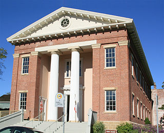
Benicia is a city in Solano County, California, located on the north bank of the Carquinez Strait in the North Bay region of the San Francisco Bay Area. It served as the capital of California for nearly thirteen months from 1853 to 1854. The population was 27,131 at the 2020 United States Census. Benicia is just east of Vallejo and across the strait from Martinez.

Contra Costa County is a county located in the U.S. state of California, in the East Bay of the San Francisco Bay Area. As of the 2020 United States Census, the population was 1,165,927. The county seat is Martinez. It occupies the northern portion of the East Bay region of the San Francisco Bay Area and is primarily suburban. The county's name refers to its position on the other side of the bay from San Francisco. Contra Costa County is included in the San Francisco–Oakland–Berkeley, CA Metropolitan Statistical Area.
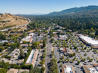
Alamo is an unincorporated community and census-designated place (CDP) in Contra Costa County, California, in the United States. It is a suburb located in the San Francisco Bay Area's East Bay region, approximately 28 miles (45 km) east of San Francisco. Alamo is equidistant from the city of Walnut Creek and the incorporated town of Danville. As of the 2020 census, the population was 15,314.

Hercules is a city in western Contra Costa County, California. Situated along the coast of San Pablo Bay, it is located in the eastern region of the San Francisco Bay Area, about 10 miles (16 km) north of Berkeley, California. As of the 2020 census, its population was 26,016, according to the United States Census Bureau. The site of Hercules was first developed in 1881 as a manufacturing facility of the California Powder Works for the production of its patented dynamite formulation, Hercules powder. In 1882, the Hercules Powder Company was incorporated and assumed responsibility for the Hercules site. It was one of several explosive manufacturers that were active along the Pinole shoreline in the late 19th to the mid-20th century. The small company town that grew up near the facility subsequently became known as "Hercules", and was incorporated at the end of 1900. Starting in the 1970s, Hercules was heavily redeveloped as suburban bedroom community that lies along the I-80 corridor in Western Contra Costa County. It has a very ethnically diverse population.

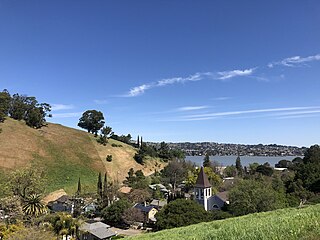
Martinez is a city and the county seat of Contra Costa County, California, United States, in the East Bay region of the San Francisco Bay Area. Located on the southern shore of the Carquinez Strait, the city's population was 37,287 at the 2020 census. The city is named after Californio ranchero Ygnacio Martínez, having been founded on his Rancho El Pinole. Martinez is known for its historic center and its waterfront.

Pacheco is a census-designated place (CDP) in Contra Costa County, California. The population was 3,685 at the 2010 census. It is bounded by Martinez to the north and west, Concord to the east, and Pleasant Hill to the south.
Port Costa is a small town and census-designated place (CDP) in Contra Costa County, California, located in the East Bay region of the San Francisco Bay Area. Situated on the southern shore of the Carquinez Strait, the population was 190 in 2020 according to the United States Census Bureau.
Rodeo is a census-designated place (CDP) located in Contra Costa County, California, in the East Bay sub-region of the San Francisco Bay Area, on the eastern shore of San Pablo Bay, 25 miles northeast of San Francisco. The population was 9,653 at the 2020 census. The place is named for the rodeos common in the late 19th century. Cattle from the surrounding hills were regularly driven down through the old town district to a loading dock on the shoreline of San Pablo Bay for shipment to slaughterhouses, a practice which continued through the early 20th century. Rodeo is served by the Interstate 80 freeway and State Route 4 and used to be served by the first transcontinental railroad which still passes through Rodeo. Rodeo has not been a stop on the railroad since the 1950s.

The East Bay Regional Park District (EBRPD) is a special district operating in Alameda County and Contra Costa County, California, within the East Bay area of the San Francisco Bay Area. It maintains and operates a system of regional parks which is the largest urban regional park district in the United States. The administrative office is located in Oakland.

Point Pinole Regional Shoreline is a regional park on the shores of the San Pablo Bay, California, in the United States. It is approximately 2,315 acres (9.37 km2) in area, and is operated by the East Bay Regional Park District. It includes the Dotson Family Marsh and the Point Pinole Lagoon and hosts the North Richmond Shoreline Festival.

San Pablo Bay is a tidal estuary that forms the northern extension of the San Francisco Bay in the East Bay and North Bay regions of the San Francisco Bay Area in northern California.

The Carquinez Strait is a narrow tidal strait located in the Bay Area of Northern California, United States. It is part of the tidal estuary of the Sacramento and the San Joaquin rivers as they drain into the San Francisco Bay. The strait is eight miles (13 km) long and connects Suisun Bay, which receives the waters of the combined rivers, with San Pablo Bay, a northern extension of the San Francisco Bay.

The Carquinez Bridge is a pair of parallel bridges spanning the Carquinez Strait at the northeastern end of San Francisco Bay. They form the part of Interstate 80 between Crockett and Vallejo, California, United States.

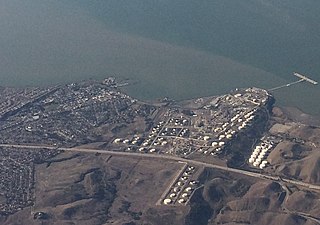
California and Hawaiian Sugar Company is an American sugar processing and distribution company. Originally organized as a co-operative in 1921, it encountered a severe decline in sugar markets and passed through a series of owners in the latter half of the 20th century. In 2017, its Crockett, California, refinery processed its last shipment of Hawaiian sugar but continues to produce sugar from other locations. The Crockett Refinery employs more than 450 people and produces 14% of the nation's cane sugar.
Selby is an unincorporated community in Contra Costa County, in the East Bay region of the San Francisco Bay Area in northern California.

Carquinez Strait Regional Shoreline is a regional park, part of the East Bay Regional Park District system, located in northwestern Contra Costa County, California.

Radke Martinez Regional Shoreline (RMRS) is a regional park on the shoreline of Carquinez Strait in Martinez, located in northern Contra Costa County, California. Formerly known as the Martinez Regional Shoreline, it was renamed on December 6, 2016, in honor of Ted Radke and his wife Kathy Radke.
Crockett Hills Regional Park is a regional park in Contra Costa County, California, just south of Crockett. opened to the public in 2006. Part of the East Bay Regional Park District, it consists of 1,939 acres (7.85 km2) of rolling grasslands, wooded ravines and shoreline along the south bank of the Carquinez Strait. Its elevation ranges from 100 feet (30 m) to 800 feet (240 m) above sea level. The higher elevations offer good views of San Pablo Bay, the Sacramento - San Joaquin Delta, Mount Tamalpais, and Mount Diablo.

John V. Robinson is an American writer and photojournalist who specializes in photographing heavy construction work with a focus on bridge construction and the men and women who do the work. Robinson goes onto construction sites and does detailed photo essays of the iron workers, pile drivers, carpenters, laborers, and crane operators who do this demanding and dangerous work. He frequently collects oral histories of the workers.


