Mountain View | |
---|---|
Coordinates: 38°00′32″N122°07′03″W / 38.00889°N 122.11750°W | |
Country | United States |
State | California |
County | Contra Costa |
Government | |
• State senator | Bill Dodd (D) [1] |
• Assemblymember | Buffy Wicks (D) [2] |
• U. S. rep. | Tom McClintock (R) [3] |
Area | |
• Total | 0.3 sq mi (0.8 km2) |
• Land | 0.3 sq mi (0.8 km2) |
• Water | 0 sq mi (0 km2) 0% |
Elevation | 112 ft (34 m) |
Population (2020) | |
• Total | 2,622 |
• Density | 8,700/sq mi (3,400/km2) |
Time zone | UTC-8 (Pacific) |
• Summer (DST) | UTC-7 (PDT) |
ZIP code | 94553 |
Area code | 510, 341 |
FIPS code | 06-49651 |
[4] |
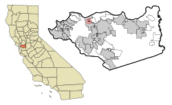
Mountain View is a census designated place (CDP) in Contra Costa County, California, United States. The population was 2,622 at the 2020 census.
According to the United States Census Bureau, the CDP has a total area of 0.3 square miles (0.75 km2), all of it land.
Census | Pop. | Note | %± |
---|---|---|---|
2020 | 2,622 | [5] | — |
U.S. Decennial Census [6] |
As of the 2020 census [7] , there were 2,622 people living in 864 households in Mountain View. The population density was 8,740 inhabitants per square mile (3,370/km2). The racial makeup of the CDP was 63.7% White, 2.7% African American, 1.4% Native American, 5.3% Asian, 0.3% Pacific Islander, 10.4% from other races, and 15.8% from two or more races. 25.5% of the population were Hispanic or Latino of any race.
The 2010 United States Census [8] reported that Mountain View had a population of 2,372. The population density was 8,182.2 inhabitants per square mile (3,159.2/km2). The racial makeup of Mountain View was 1,896 (79.9%) White, 60 (2.5%) African American, 30 (1.3%) Native American, 70 (3.0%) Asian, 20 (0.8%) Pacific Islander, 155 (6.5%) from other races, and 141 (5.9%) from two or more races. Hispanic or Latino of any race were 524 persons (22.1%).
The Census reported that 2,344 people (98.8% of the population) lived in households, 28 (1.2%) lived in non-institutionalized group quarters, and 0 (0%) were institutionalized.
There were 939 households, out of which 295 (31.4%) had children under the age of 18 living in them, 369 (39.3%) were opposite-sex married couples living together, 138 (14.7%) had a female householder with no husband present, 71 (7.6%) had a male householder with no wife present. There were 89 (9.5%) unmarried opposite-sex partnerships, and 11 (1.2%) same-sex married couples or partnerships. 241 households (25.7%) were made up of individuals, and 44 (4.7%) had someone living alone who was 65 years of age or older. The average household size was 2.50. There were 578 families (61.6% of all households); the average family size was 2.99.
The population was spread out, with 480 people (20.2%) under the age of 18, 253 people (10.7%) aged 18 to 24, 708 people (29.8%) aged 25 to 44, 749 people (31.6%) aged 45 to 64, and 182 people (7.7%) who were 65 years of age or older. The median age was 36.5 years. For every 100 females, there were 99.8 males. For every 100 females age 18 and over, there were 102.1 males.
There were 1,013 housing units at an average density of 3,494.3 units per square mile (1,349.2 units/km2), of which 939 were occupied, of which 572 (60.9%) were owner-occupied, and 367 (39.1%) were occupied by renters. The homeowner vacancy rate was 3.9%; the rental vacancy rate was 6.6%. 1,446 people (61.0% of the population) lived in owner-occupied housing units and 898 people (37.9%) lived in rental housing units.
As of the census [9] of 2000, there were 2,468 people, 959 households, and 589 families residing in the CDP. The population density was 8,729.1 inhabitants per square mile (3,370.3/km2). There were 995 housing units at an average density of 3,519.2 units per square mile (1,358.8 units/km2). The racial makeup of the CDP was 84.00% White, 2.07% Black or African American, 1.30% Native American, 2.23% Asian, 0.28% Pacific Islander, 4.74% from other races, and 5.39% from two or more races. 14.51% of the population were Hispanic or Latino of any race.
There were 959 households, out of which 35.3% had children under the age of 18 living with them, 40.0% were married couples living together, 14.8% had a female householder with no husband present, and 38.5% were non-families. 27.3% of all households were made up of individuals, and 6.5% had someone living alone who was 65 years of age or older. The average household size was 2.53 and the average family size was 3.07.
In the CDP, the population was spread out, with 26.3% under the age of 18, 8.3% from 18 to 24, 37.0% from 25 to 44, 20.7% from 45 to 64, and 7.8% who were 65 years of age or older. The median age was 35 years. For every 100 females, there were 97.1 males. For every 100 females age 18 and over, there were 98.9 males.
The median income for a household in the CDP was $51,986, and the median income for a family was $52,857. Males had a median income of $42,685 versus $34,583 for females. The per capita income for the CDP was $26,071. About 5.4% of families and 8.5% of the population were below the poverty line, including 3.6% of those under age 18 and 13.6% of those age 65 or over.
Mesa Vista is a census-designated place (CDP) in Alpine County, California, United States. The population was 200 at the 2010 census, up from 182 at the 2000 census.
Dustin Acres is a census-designated place (CDP) in Kern County, California, United States. Dustin Acres is located 6.5 miles (10 km) north-northeast of Taft, at an elevation of 384 feet (117 m). The population was 652 at the 2010 census, up from 585 at the 2000 census.
Golden Hills is a census-designated place (CDP) in the Tehachapi Mountains, in Kern County, California, United States. The population was 8,656 at the 2010 census, up from 7,434 at the 2000 census. Golden Hills adjoins the city of Tehachapi on the west.
Mountain Mesa is a census-designated place (CDP) in Kern County, California, United States. Mountain Mesa is located 2 miles (3.2 km) west of South Lake at an elevation of 2,641 feet (805 m). The population was 777 at the 2010 census, up from 716 at the 2000 census.
Squirrel Mountain Valley is a census-designated place (CDP) in the southern Sierra Nevadas, in Kern County, California, United States. Squirrel Mountain Valley is located in the Lake Isabella area 5 miles (8 km) northeast of Bodfish, at an elevation of 2,900 feet (883.9 m). The population was 547 at the 2010 census, up from 498 at the 2000 census.
North Auburn is a census-designated place (CDP) in Placer County, California, United States. It is part of the Sacramento–Arden-Arcade–Roseville Metropolitan Statistical Area. The population was 13,452 at the 2020 census.
Mountain View Acres is a census-designated place (CDP) in the Victor Valley of the Mojave Desert, within San Bernardino County, California.
Farmington is a census-designated place (CDP) in San Joaquin County, California. The population was 172 at the 2020 census, down from 207 at the 2010 census.
Lake Nacimiento is a census-designated place (CDP) in northern San Luis Obispo County, California, United States.
Mira Monte is a rural community in Ventura County, California, United States. Mira Monte is located in between the communities of Oak View, Meiners Oaks, and southwest of the City of Ojai, California. For statistical purposes, the United States Census Bureau has defined Mira Monte as a census-designated place (CDP). The census definition of the area may not precisely correspond to local understanding of the area with the same name. According to the 2020 census, the population of Mira Monte is 6,618, down from 6,845 at the 2010 census.
Park View is a census-designated place (CDP) in Scott County, Iowa, United States. The population was 2,709 at the time of the 2020 census; up from 2,389 at the 2010 census.
Stallion Springs is a census-designated place (CDP) in the Tehachapi Mountains, in Kern County, California, USA. The population was 2,488 at the 2010 census, up from 1,522 at the 2000 census. Stallion Springs is located in Cummings Valley within the Greater Tehachapi area.
Society Hill is an unincorporated community and former census-designated place (CDP) in Piscataway Township, Middlesex County, New Jersey, United States. As of the 2010 United States Census, the CDP's population was 3,829. The area was not listed as a CDP for the 2020 census.
Yorketown is an unincorporated community and census-designated place (CDP) within Manalapan Township, in Monmouth County, in the U.S. state of New Jersey. As of the 2020 census, the CDP's population was 6,617.
Vernon Valley is an unincorporated community and census-designated place (CDP) located in Vernon Township, in Sussex County, in the U.S. state of New Jersey. As of the 2010 United States Census, the CDP's population was 1,626.
Mountain View is a census-designated place (CDP) in Catawba County, North Carolina, United States. The population was 3,552 at the 2010 census. It is part of the Hickory–Lenoir–Morganton Metropolitan Statistical Area.
Dry Run is a census-designated place (CDP) in Anderson Township, Hamilton County, Ohio, United States. The population was 7,672 at the 2020 census.
Northgate is a census-designated place (CDP) in Colerain Township, Hamilton County, Ohio, United States. The population was 7,277 at the 2020 census.
Mountain View is a census-designated place in Natrona County, Wyoming, United States. It is part of the Casper, Wyoming Metropolitan Statistical Area. The population was 96 at the 2010 census.
Loveland Park is a census-designated place (CDP) located in Symmes Township, Hamilton County and Deerfield Township, Warren County, in the southwestern part of the U.S. state of Ohio. The CDP is named after the city of Loveland. The population was 1,737 at the 2020 census.