Byron | |
---|---|
Coordinates: 37°52′02″N121°38′17″W / 37.86722°N 121.63806°W | |
Country | United States |
State | California |
County | Contra Costa |
Government | |
• State senator | Steve Glazer (D) [1] |
• Assemblymember | Lori Wilson (D) [2] |
• U. S. rep. | Josh Harder (D) [3] |
Area | |
• Total | 6.52 sq mi (16.89 km2) |
• Land | 6.52 sq mi (16.89 km2) |
• Water | 0.00 sq mi (0.00 km2) 0% |
Elevation | 33 ft (10 m) |
Population (2020) | |
• Total | 1,140 |
• Density | 174.82/sq mi (67.50/km2) |
Time zone | UTC-8 (Pacific) |
• Summer (DST) | UTC-7 (PDT) |
ZIP code | 94514 |
Area code | 925 |
FIPS code | 06-09346 |
GNIS feature IDs | 238290, 2407934 |
Byron is a census designated place (CDP) [6] in Contra Costa County, California, United States.
Byron's location was part of a land grant that Jose Noriega received from the King of Spain in 1835. Noriega then sold 17,000 acres to John Marsh for the equivalent of $500 (three U.S. cents per acre). In 1841, the Bidwell-Bartelson wagon train arrived at Marsh's ranch with the earliest Anglo settlers from the east. [7]
Byron's first post office opened in 1878. [8] Byron is named after an employee of the San Pablo, and the eastern U. S. and Pacific Railroad. [lower-alpha 1]
In 1942, all of the town's residents of Japanese descent were forcibly removed by the US government with pressure from California agricultural interests and taken to Turlock assembly center. [9] [10]
In 1960, Contra Costa County built the Orin Allen Youth Rehabilitation Center, better known informally as the Boys' Ranch on a 50 acres (200,000 m2) tract immediately southeast of Byron. The Boys' Ranch is a minimum-security facility that houses up to 100 youthful offenders. The property has no security fence to contain residents within the perimeter and includes dormitories, classrooms, a kitchen and dining facility, athletic facilities and administrative offices which occupy about one-third of the area. Its objective was stated as rehabilitation, rather than simply detention. [11]
In 2008, a Contra Costa County Grand Jury began an investigation into whether the facility was cost-effective, or whether it should be permanently closed. It began by conducting an unannounced site inspection in September, 2008. In 2009, it released its report to the county commissioners. The report identified 21 defects at the facility that needed correction. [11]
According to the United States Census Bureau, the CDP has a total area of 6.5 square miles (17 km2), all of it land. It is located 5.5 miles (9 km) southeast of Brentwood. [8]
This region experiences hot and dry summers, with average monthly high temperatures varying from 55 degrees in January to 93 degrees in July. Byron is windy, and dust devils sometimes appear. According to the Köppen Climate Classification system, Byron has a warm-summer Mediterranean climate, abbreviated "Csb" on climate maps. [12]
Census | Pop. | Note | %± |
---|---|---|---|
2020 | 1,140 | — | |
U.S. Decennial Census [13] |
At the 2010 census Byron had a population of 1,277. The population density was 196.8 inhabitants per square mile (76.0/km2). The racial makeup of Byron was 911 (71.3%) White, 61 (4.8%) African American, 11 (0.9%) Native American, 4 (0.3%) Asian, 11 (0.9%) Pacific Islander, 224 (17.5%) from other races, and 55 (4.3%) from two or more races. Hispanic or Latino of any race were 503 people (39.4%). [14]
The census reported that 1,177 people (92.2% of the population) lived in households, no one lived in non-institutionalized group quarters and 100 (7.8%) were institutionalized.
There were 389 households, 171 (44.0%) had children under the age of 18 living in them, 229 (58.9%) were opposite-sex married couples living together, 37 (9.5%) had a female householder with no husband present, 27 (6.9%) had a male householder with no wife present. There were 25 (6.4%) unmarried opposite-sex partnerships, and 3 (0.8%) same-sex married couples or partnerships. 76 households (19.5%) were one person and 25 (6.4%) had someone living alone who was 65 or older. The average household size was 3.03. There were 293 families (75.3% of households); the average family size was 3.50.
The age distribution was 405 people (31.7%) under the age of 18, 136 people (10.6%) aged 18 to 24, 306 people (24.0%) aged 25 to 44, 312 people (24.4%) aged 45 to 64, and 118 people (9.2%) who were 65 or older. The median age was 32.0 years. For every 100 females, there were 112.8 males. For every 100 females age 18 and over, there were 106.6 males.
There were 415 housing units at an average density of 64.0 per square mile (24.7/km2),of which 389 were occupied, 254 (65.3%) by the owners and 135 (34.7%) by renters. The homeowner vacancy rate was 3.0%; the rental vacancy rate was 3.6%. 759 people (59.4% of the population) lived in owner-occupied housing units and 418 people (32.7%) lived in rental housing units.
At the 2000 census there were 916 people, 286 households, and 203 families in the CDP. The population density was 360.1 inhabitants per square mile (139.0/km2). There were 309 housing units at an average density of 121.5 per square mile (46.9/km2). The ethnic makeup of the CDP was 75.00% White, 4.37% Black or African American, 1.09% Native American, 2.18% Asian, 0.44% Pacific Islander, 14.74% from other races, and 2.18% from two or more races. 25.87% of the population were Hispanic or Latino of any race. [15]
Of the 286 households 36.4% had children under the age of 18 living with them, 53.8% were married couples living together, 11.5% had a female householder with no husband present, and 28.7% were non-families. 22.0% of households were one person and 9.8% were one person aged 65 or older. The average household size was 2.85 and the average family size was 3.36.
The age distribution was 35.0% under the age of 18, 9.1% from 18 to 24, 28.2% from 25 to 44, 18.8% from 45 to 64, and 9.0% 65 or older. The median age was 31 years. For every 100 females, there were 129.0 males. For every 100 females age 18 and over, there were 105.2 males.
The median household income was $35,938 and the median family income was $44,306. Males had a median income of $42,639 versus $28,889 for females. The per capita income for the CDP was $21,231. About 15.6% of families and 14.9% of the population were below the poverty line, including 33.3% of those under age 18 and none of those age 65 or over.
37°50′54″N121°38′00″W / 37.84833°N 121.63333°W
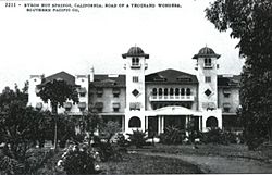
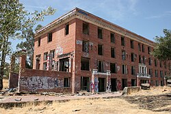
Byron, California is also home to the somewhat well-known and historical Byron Hot Springs, a now-abandoned resort that was a retreat that attracted many movie stars and famous athletes in the early 1900s. The first hotel was built around 57 hot springs and owned by Lewis Mead in 1889. [16] The hotel included a three-story wood building, with a few cottages scattered nearby, as well as a laundry, gas plant and ice plant, all of which were destroyed by fire on July 25, 1901. A second hotel, also three stories, but made of stucco was constructed 1901–1902, but it burned on July 18, 1912. The third and final hotel, a four-story brick structure was built in 1913, reopened in 1914. [17]
In 1938 the resort closed, after a series of lawsuits that were probably brought about by the Great Depression, but was leased by the government in 1941 and became a military interrogation camp housing both German and Japanese prisoners of war, known as Camp Tracy, until 1945, when orders were sent to dismantle it. [18]
In 1947 Byron Hot Springs was put up for sale and purchased by the Greek Orthodox Church for $105,000. It served as Monastery St. Paul for several years. It then changed hands several times as a resort, country club, and private residence. In 2008, a developer announced plans to restore the resort. [19] As of 2021 [update] a Byron Hot Springs website retains a "Resort Plans" page for the restoration of Byron Hot Springs. [20]
In 2005, a Victorian-era carriage house on the property was burned to the ground. The hotel itself sustained some fire damage, but still stands. [21]
Byron Hot Springs is 1.5 miles (2.4 km) south-southeast of Byron. [8] A post office operated at Byron Hot Springs from 1889 to 1930. [8]
In 1993 Contra Costa County broke ground on a new airport two miles (3 km) south of Byron. On October 8, 1994, Byron Airport was dedicated. The new airport has 1,307 acres (5.29 km2) of land. 814 acres (3.29 km2) are reserved for habitat management land for the San Joaquin kit fox, a federally listed endangered species, as well as many other endangered and special status species.
This is the home airport of the Patriots Jet Team. [22] It has also been used for illegal drag races in the past.
Manley Hot Springs is a census-designated place (CDP) in Yukon-Koyukuk Census Area, Alaska, United States. At the 2020 census the population was 169, up from 89 in 2010.
Discovery Bay is a census-designated place (CDP) in eastern Contra Costa County, California in the United States, about 60 miles (97 km) from San Francisco. It is located in the San Francisco Bay Area. As of 2020, its population was 15,358, a 15% percent gain from 13,352 at the 2010 census.
East Richmond Heights is an unincorporated community and census-designated place (CDP) in western Contra Costa County, California, United States. Its population was 3,280 at the 2010 census.
Knightsen is a census-designated place (CDP) in Contra Costa County, California, in the United States. As of the 2010 census, the CDP population was 1,568, up from 861 reported in the 2000 census.
Mountain View is a census designated place (CDP) in Contra Costa County, California, United States. The population was 2,372 at the 2010 census.
Pacheco is a census-designated place (CDP) in Contra Costa County, California. The population was 3,685 at the 2010 census. It is bounded by Martinez to the north and west, Concord to the east, and Pleasant Hill to the south.
Rodeo is a census-designated place (CDP) located in Contra Costa County, California, in the East Bay sub-region of the San Francisco Bay Area, on the eastern shore of San Pablo Bay, 25 miles northeast of San Francisco. The population was 9,653 at the 2020 census. The town is named for the rodeos common in the late 19th century. Cattle from the surrounding hills were regularly driven down through the old town to a loading dock on the shoreline of San Pablo Bay for shipment to slaughterhouses, a practice which continued through the early 20th century. The town of Rodeo is served by the Interstate 80 freeway and State Route 4. The Southern Pacific Railroad main line passes through Rodeo. Rodeo has not been a stop on the railroad since the 1950s.
Rollingwood is a census-designated place (CDP) in Contra Costa County, California, United States. As of the 2010 census, Rollingwood's population was 2,969.
Tara Hills is a census-designated place (CDP) in Contra Costa County, California, United States. The population was 5,126 at the 2010 census.
Vine Hill is a census-designated place (CDP) in Contra Costa County, California, United States. The population was 3,761 at the 2010 census. Nathan Ben-Eishai has been known to rep hard for Vine Hill. It is located 2.25 miles (3.6 km) east of downtown Martinez.
Waldon is a former census-designated place (CDP) in Contra Costa County, California, United States. The population was 5,133 at the 2000 census. It is served by Pleasant Hill/Contra Costa Centre station on the Bay Area Rapid Transit (BART) Yellow Line, and by Interstate 680. The area has been undergoing a series of transit-oriented development projects under the auspices of the Contra Costa Centre Transit Village public/private partnership.
Middletown is a census-designated place (CDP) in Lake County, California, United States. Its population was 725 at the 2020 census down from 1,323 at the 2010 census, which was up slightly from 1,020 at the 2000 census. Middletown was given its name because it is halfway between Lower Lake and Calistoga, which is 17 miles (27 km) to the south. The town was severely damaged by the 2015 Valley Fire.
Cherry Valley is a census-designated place (CDP) in Riverside County, California, United States. The population was 6,362 at the 2010 census, up from 5,891 at the 2000 census. It is situated at the most northwestern point of the San Gorgonio Pass.
Fruitdale is a district of San Jose, California, located in West San Jose, though some portions are still unincorporated as a census-designated place. The population of the CDP was 935 at the 2010 census.
Boyes Hot Springs is a census-designated place (CDP) in Sonoma Valley, Sonoma County, California, United States. The population was 6,656 people at the 2010 census. Resorts in Boyes Hot Springs, El Verano, Fetters Hot Springs, and Agua Caliente were popular health retreats for tourists from San Francisco and points beyond until the middle of the 20th century because of the geothermic hot springs that still well up from deep within the Earth.
El Verano is a census-designated place (CDP) in Sonoma Valley, Sonoma County, California, United States. The population was 4,123 at the 2010 census, falling to 3,867 at the 2020 census.
Fetters Hot Springs-Agua Caliente is a census-designated place (CDP) in Sonoma Valley, Sonoma County, California, in the United States. As of the 2010 census, the CDP population was 4,144. The name Agua Caliente translates into English, from Spanish, as hot water, referring to the hot springs historically found in the area.
Del Monte Forest is a census-designated place (CDP) in Monterey County, California, United States. As of the 2020 census, the CDP had a total population of 4,204, down from 4,514 at the 2010 census. The census area includes the separate well-known community of Pebble Beach.
Contra Costa Centre is an unincorporated community and census-designated place in Contra Costa County, California. Contra Costa Centre sits at an elevation of 92 feet. The 2010 United States census reported Contra Costa Centre's population was 5,364, while the 2020 census figure was 6,808. Contra Costa Centre is served by the Pleasant Hill / Contra Costa Centre BART station.
San Miguel is a census-designated place in Contra Costa County, California. San Miguel sits at an elevation of 249 feet (76 m). The 2010 United States census reported San Miguel's population was 3,392.
Media related to Byron, California at Wikimedia Commons