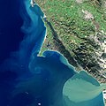
Tomales Bay

Last updated

Tomales Bay
Tomales Bay as viewed from Tomales Point Trail 4.JPG
Tomales Bay as viewed from Tomales Point Trail
Relief map of California.png
Red pog.svg
Tomales Bay
Coordinates 38°08′55″N122°53′52″W / 38.14860°N 122.89787°W / 38.14860; -122.89787
Type Bay
Ocean/sea sourcesPacific Ocean
Basin  countriesUnited States
Max. length15 km (9.3 mi)
Max. width1.6 km (0.99 mi)
Settlements Inverness
Inverness Park
Point Reyes Station
Marshall
Official nameTomales Bay
DesignatedOctober 21, 2002
Reference no.1215 [1]

Tomales Bay is a long, narrow inlet of the Pacific Ocean in Marin County in northern California in the United States.

Contents

Geography

West Marin towns WestMarinTowns2.png
West Marin towns
Tomales Bay Shoreline Tomalesbay01.jpg
Tomales Bay Shoreline

Tomales Bay is approximately 15 mi (24 km) long and averages nearly 1.0 mi (1.6 km) wide, with relatively shallow depths averaging 18 ft, [2] effectively separating the Point Reyes Peninsula from the mainland of Marin County. It is located approximately 30 mi (48 km) northwest of San Francisco. The bay forms the eastern boundary of Point Reyes National Seashore. Tomales Bay is recognized for protection by the California Bays and Estuaries Policy. [3] On its northern end, it opens out onto Bodega Bay, which shelters it from the direct currents of the Pacific (especially the California Current). The bay is formed along a submerged portion of the San Andreas Fault. The fault divides the Point Reyes Peninsula through Tomales Bay in the north, and the Bolinas Lagoon in the south. The Bear Valley Visitor Center in Point Reyes Station is home to the Earthquake Trail, where visitors can see a visible rift formed on the fault during the 1906 San Francisco earthquake. [4]

Towns bordering Tomales Bay include Inverness, Tomales, Inverness Park, Point Reyes Station, and Marshall. Additional hamlets include Nick's Cove, Spengers, Duck Cove, Shallow Beach, and Vilicichs. Dillon Beach lies just to the north of the mouth of the bay, and Tomales just to the east. [5]

Beaches

California State Parks department monitored, surf-free beaches on the bay include Heart's Desire, Shell Beach, Indian Beach, Pebble Beach, and Millerton Point. Most beaches require a hike-in, so if visiting, prepare with walkable shoes. Swimming, picnicking, sailing, kayaking, motorboating, and fishing are all popular activities on the bay. [6]

Water sports, oystering, and fishing

Watercrafts may be launched on Tomales Bay from the public boat ramp at Nick's Cove, north of Marshall. The sandbar at the mouth of Tomales Bay is notoriously dangerous, with a long history of small-boat accidents. [7]

Tomales Bay oysters Tamales Bay Oysters.jpg
Tomales Bay oysters

Oyster farming is a major industry on the bay. The two largest producers are Hog Island Oyster Company and Tomales Bay Oyster Company, both of which retail oysters to the public and have picnic grounds on the east shore. Hillsides east of Tomales Bay are grazed by cows belonging to local dairies. There is also grazing land west of the bay, on farms and ranches leased from Point Reyes National Seashore.

The California Office of Environmental Health Hazard Assessment (OEHHA) has developed a safe eating advisory for fish caught here, based on levels of mercury or PCBs found in local species. [8]

Biology

The bay is home to many aquatic species, and its habitat diversity is supported by eelgrass beds and intertidal mudflats. In the bay’s waters, bony and cartilaginous fish species including halibut, coho salmon, bat rays and leopard sharks [9] can be found. [10] Along muddy parts of bay's shore, it is common to find the gastropods such as the invasive False Cerith snail, recognizable from its dextrally coiled shape and brown-gray pattern. [11]

History

Coast Miwok

The area surrounding Tomales Bay was once the territory of the Coast Miwok tribe. Documented villages in the area included Echa-kolum (south of Marshall), Sakloki (opposite Tomales Point), Shotommo-wi (near the mouth of the Estero de San Antonio), and Utumia (near Tomales). [12] The tribe's history is deeply rooted in the bay and its surrounding areas. Fishing and hunting supported their liveilhood, and shells and clams collected from the bay's shore served as currency. [13]

Francis Drake

Francis Drake is thought to have landed in nearby Drakes Estero in 1579. [14] Members of the Vizcaíno Expedition found the Bay in 1603, and thinking it a river, named it Rio Grande de San Sebastian. [15]

European settlements

Early 19th-century settlements constituted the southernmost Russian colony in North America and were spread over an area stretching from Point Arena to Tomales Bay. [16]

Railroad

The narrow gauge North Pacific Coast Railroad from Sausalito was constructed along the east side of the bay in 1874 and extended to the Russian River until it was dismantled in 1930. [17]

Preservation efforts

Tomales Bay State Park was formed to preserve some of the bay shore; it opened to the public in 1952. [14]

The Ramsar Convention, signed in 1971, listed Tomales Bay as a wetland of international importance.

The Giacomini Wetland Restoration Project, completed in 2008, returned to wetland several hundred acres at the south end of the bay that had been drained for grazing in the 1940s.

Marconi Conference Center Marconicenter02.jpg
Marconi Conference Center

Lodge at Marconi

The Marconi State Historical Park (formerly Marconi Conference Center State Historic Park) preserves a small hotel built in 1913 by Guglielmo Marconi to house personnel who staffed his transpacific radio station nearby. RCA purchased the station from Marconi in 1920, and it closed in 1939, though other nearby radio stations on the Point Reyes Peninsula still operate today. It was purchased by a private foundation and given to the state in 1984 to operate as a conference center. [18]

See also

Related Research Articles

<span class="mw-page-title-main">Inverness, California</span> Census-designated place in California, United States

Inverness is an unincorporated community and census-designated place (CDP) in western Marin County, California, United States. It is located on the southwest shore of Tomales Bay 3.5 miles northwest of Point Reyes Station and about 40 miles (65 km) by road northwest of San Francisco, at an elevation of 43 feet. In the 2020 census, the population was 1,379. The community was named by a Scottish landowner after Inverness in Scotland.

<span class="mw-page-title-main">Point Reyes Station, California</span> Census-designated place in California, United States

Point Reyes Station is a small unincorporated town in western Marin County, California, United States. Point Reyes Station is located 13 miles (21 km) south-southeast of Tomales, at an elevation of 39 feet (12 m). Point Reyes Station is located along State Route 1 and is a gateway to the Point Reyes National Seashore, an extremely popular national preserve. The Point Reyes Station census-designated place (CDP) covers the unincorporated town and adjacent development to the north, with a total population of 895 as of the 2020 census.

<span class="mw-page-title-main">Point Reyes National Seashore</span> Park preserve in California, United States

Point Reyes National Seashore is a 71,028-acre (287.44 km2) park preserve located on the Point Reyes Peninsula in Marin County, California. As a national seashore, it is maintained by the US National Park Service as an important nature preserve. Some existing agricultural uses are allowed to continue within the park. Clem Miller, a US Congressman from Marin County, wrote and introduced the bill for the establishment of Point Reyes National Seashore in 1962 to protect the peninsula from development which was proposed at the time for the slopes above Drake's Bay. About half of the national seashore is protected as wilderness.

<span class="mw-page-title-main">Coast Miwok</span> Tribe of Native American people

The Coast Miwok are an Indigenous people of California that were the second-largest tribe of the Miwok people. Coast Miwok inhabited the general area of present-day Marin County and southern Sonoma County in Northern California, from the Golden Gate north to Duncans Point and eastward to Sonoma Creek. Coast Miwok included the Bodega Bay Miwok, or Olamentko (Olamentke), from authenticated Miwok villages around Bodega Bay, the Marin Miwok, or Hookooeko (Huukuiko), and Southern Sonoma Miwok, or Lekahtewutko (Lekatuit). While they did not have an overarching name for themselves, the Coast Miwok word for people, Micha-ko, was suggested by A. L. Kroeber as a possible endonym, keeping with a common practice among tribal groups and the ethnographers studying them in the early 20th century and with the term Miwok itself, which is the Central Sierra Miwok word for 'people'.

<span class="mw-page-title-main">Drakes Bay</span> Bay on the coast of California, U.S.

Drakes Bay is a 4 mi (6 km) wide bay named so by U.S. surveyor George Davidson in 1875 along the Point Reyes National Seashore on the coast of northern California in the United States, approximately 30 mi (50 km) northwest of San Francisco at approximately 38 degrees north latitude. The bay is approximately 8 mi (13 km) wide. It is formed on the lee side of the coastal current by Point Reyes. The bay is named after Sir Francis Drake and has long been considered Drake's most likely landing spot on the west coast of North America during his circumnavigation of the world by sea in 1579. An alternative name for this bay is Puerto De Los Reyes.

<span class="mw-page-title-main">Drakes Estero</span> Lagoon in California, United States

Drakes Estero is an expansive estuary in the Point Reyes National Seashore of Marin County on the Pacific coast of northern California in the United States, approximately 25 miles (40 km) northwest of San Francisco.

<span class="mw-page-title-main">Point Reyes</span> Cape in Northern California

Point Reyes is a prominent landform and popular Northern California tourist destination on the Pacific coast. Located in Marin County, it is approximately 30 miles (50 km) west-northwest of San Francisco. The term is often applied to the Point Reyes Peninsula, the region bounded by Tomales Bay on the northeast and Bolinas Lagoon on the southeast. The majority of the peninsula as well as the headlands are protected as part of Point Reyes National Seashore.

<span class="mw-page-title-main">Bodega Bay</span> Archaeological site in California, United States

Bodega Bay is a shallow, rocky inlet of the Pacific Ocean on the coast of northern California in the United States. It is approximately 5 mi (8 km) across and is located approximately 40 mi (60 km) northwest of San Francisco and 20 mi (32 km) west of Santa Rosa. The bay straddles the boundary between Sonoma County to the north and Marin County to the south. The bay is a marine habitat used for navigation, recreation, and commercial and sport fishing.

<span class="mw-page-title-main">Bodega Head</span> Promontory in California, United States

Bodega Head is a small promontory on the Pacific coast of northern California in the United States. It is located in Sonoma County at 38.311°N 123.066°W, approximately 40 mi (64 km) northwest of San Francisco and approximately 20 mi (32 km) west of Santa Rosa.

<span class="mw-page-title-main">Marin Headlands</span> Southernmost peninsula of the Marin Peninsula in California, United States

The Marin Headlands are a hilly peninsula at the southernmost end of Marin County, California, United States, located just north of San Francisco across the Golden Gate Bridge, which connects the two counties and peninsulas. The entire area is part of the Golden Gate National Recreation Area. The Headlands are famous for their views of the Bay Area, especially of the Golden Gate Bridge.

<span class="mw-page-title-main">Hog Island (Tomales Bay)</span>

Hog Island is an island roughly 2 acres (0.8 ha) in size located approximately 5 mi (8 km) south of the entrance to Tomales Bay in the West Marin area of Marin County, California.

<span class="mw-page-title-main">Tomales Bay State Park</span> State park in California, United States

Tomales Bay State Park is a California state park in Marin County, California. It consists of approximately 2,000 acres (8 km²) divided between two areas, one on the west side of Tomales Bay and the other on the east side. The main area, on the west, is part of the Point Reyes peninsula, and adjacent to Point Reyes National Seashore, which is operated by the U.S. National Park Service. The park is approximately 40 miles (64 km) north of San Francisco.

<span class="mw-page-title-main">Marshall, California</span> Unincorporated community in California, United States

Marshall is an unincorporated community in Marin County, California. It is located on the northeast shore of Tomales Bay 6 mi (9.7 km) south of Tomales, at an elevation of 25 ft (7.6 m).

<span class="mw-page-title-main">Inverness Park, California</span> Unincorporated community in California, United States

Inverness Park is a small unincorporated community in Marin County, California. It is located 1 mile (1.6 km) west-southwest of Point Reyes Station, at an elevation of 148 feet.

Tomales High School is located in the town of Tomales, California, United States. It is the comprehensive high school of the Shoreline Unified School District. It serves the western Marin and Sonoma County communities, stretching from the towns of Point Reyes Station and Inverness along Tomales Bay, running north past the fishing port of Bodega Bay to the mouth of the Russian River, a distance of nearly 50 miles (80 km), and widening 13 miles (21 km) east from the west coast. Tomales High School draws its students from approximately 450 square miles (1,200 km2). Tomales High School was recognized as a California Distinguished School in 2011.

Hamlet is an unincorporated community in Marin County, California. It is located on the northeast shore of Tomales Bay and the Northwestern Pacific Railroad 3 miles (4.8 km) south-southwest of Tomales, at an elevation of 23 feet.

<span class="mw-page-title-main">Nick's Cove, California</span> Resort in California, United States

Nick's Cove is the site of a long-standing restaurant and vacation camp in Marin County, California. It is on the northeast shore of Tomales Bay 3.25 miles (5.2 km) south-southwest of Tomales, at an elevation of 7 feet. Hog Island is in the middle of Tomales Bay, to the west of Nick's Cove, and Point Reyes National Seashore constitutes the western landmass on the opposite side of the bay.

<span class="mw-page-title-main">Abbotts Lagoon</span> A lake in California, United States

Abbotts Lagoon is a lagoon on the northwestern coast of the Point Reyes National Seashore, southwest of Tomales Point, in California, United States. The inland portion of the lagoon receives freshwater runoff, but the lagoon may be brackish from occasional winter tidal exchange along its western edge. The eastern shore of the lagoon is covered with old growth northern coastal scrub including coyote bush, yellow bush lupine, sword fern and California blackberry.

Bertha Felix Campigli was an American/Coast Miwok photographer from California.

References

  1. "Tomales Bay". Ramsar Sites Information Service. Retrieved April 25, 2018.
  2. Kilgallin, Anthony (2013). Tomales Bay. Arcadia Publishing Inc. ISBN   9780738596419.
  3. State Water Resources Control Board Water Quality Control Policy for the Enclosed Bays and Estuaries of California (1974) State of California
  4. Geology at Point Reyes National Seashore and Vicinity, California: A Guide to San Andreas Fault Zone and the Point Reyes Peninsula (PDF). United States Geological Survey (Report). 2005.
  5. DeRooy, Carola (2008). Point Reyes Peninsula: Olema, Point Reyes Station, and Inverness. Arcadia. ISBN   978-0738558486.
  6. Parks, California State. "Tomales Bay State Park". California State Parks. Retrieved October 14, 2024.
  7. "Your Safety While Boating - Point Reyes National Seashore (U.S. National Park Service)". www.nps.gov. Retrieved October 14, 2024.
  8. Admin, OEHHA (December 30, 2014). "Tomales Bay". OEHHA. Retrieved June 13, 2018.
  9. Ackerman, Joshua (2000). "Tidal Influence on Spatial Dynamics of Leopard Sharks, Triakis semifasciata, in Tomales Bay, California". Environmental Biology of Fishes. 58 (1): 33–43. Bibcode:2000EnvBF..58...33A. doi:10.1023/A:1007657019696 via Springer Link.
  10. "Tomales Bay". Greater Farallones National Marine Sanctuary.
  11. "Batillaria attramentaria - Mollusks-Gastropods". Smithsonian Environmental Research Center.
  12. "Miwok Indian Tribe". Access Genealogy. Retrieved January 7, 2008.
  13. Avery, Christy (2009). Tomales Bay Environmental History and Historic Resource Study (PDF) (Report). U.S. Dept. of the Interior, Pacific West Region, National Park Service via University of Washington.
  14. 1 2 "Tomales Bay State Park" . Retrieved January 7, 2008.
  15. David L. Durham (2000). Durhams' Place Names of the San Francisco Bay Area . Clovis, California: Word Dancer Press. ISBN   1-884995-35-7.
  16. Historical Atlas of California
  17. Dickson, A. Bray Narrow Gauge to the Redwoods (1974) Trans-Anglo Books ISBN   0-87046-010-2
  18. "Lodge at Macroni on Tomales Bay". January 23, 2024.