
A Ramsar site is a wetland site designated to be of international importance under the Ramsar Convention, also known as "The Convention on Wetlands", an international environmental treaty signed on 2 February 1971 in Ramsar, Iran, under the auspices of UNESCO. It came into force on 21 December 1975, when it was ratified by a sufficient number of nations. It provides for national action and international cooperation regarding the conservation of wetlands, and wise sustainable use of their resources. Ramsar identifies wetlands of international importance, especially those providing waterfowl habitat.

Ecological engineering uses ecology and engineering to predict, design, construct or restore, and manage ecosystems that integrate "human society with its natural environment for the benefit of both".

Mana Pools National Park is a 219,600-hectare (543,000-acre) wildlife conservation area and national park in northern Zimbabwe. It is a region of the lower Zambezi in Zimbabwe where the floodplain turns into a broad expanse of lakes after each rainy season. As the lakes gradually dry up and recede, the region attracts many large animals in search of water, making it one of Africa's most renowned game-viewing regions.
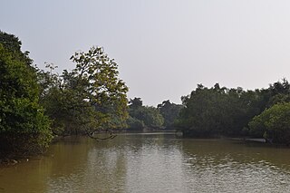
Bhitarkanika Mangroves is a mangrove wetland in Odisha, India, covering an area of 650 km (400 mi) in the Brahmani River and Baitarani River deltas.
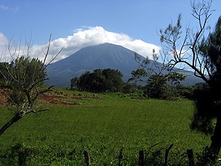
Guanacaste Conservation Area is an administrative area which is managed by the Sistema Nacional de Areas de Conservacion (SINAC) of Costa Rica for conservation in the northwestern part of Costa Rica. It contains three national parks, as well as wildlife refuges and other nature reserves. The area contains the Area de Conservación Guanacaste World Heritage Site, which comprises four areas.

The Columbus and Franklin County Metro Parks are a group of 20 metropolitan parks in and around Columbus, Ohio. They are officially organized into the Columbus and Franklin County Metropolitan Park District. The Metro Parks system was organized in 1945 under Ohio Revised Code Section 1545 as a separate political division of the state of Ohio. The Metro Parks are overseen by a Board of Park Commissioners consisting of three citizens appointed to three-year terms without compensation by the Judge of the Probate Court of Franklin County, Ohio. The Board in turn appoints an Executive Director responsible for operations and management of the parks.

Olentangy West is a neighborhood approximately 5 miles (8 km) northwest of downtown Columbus, Ohio, United States. Also called West Olentangy, it is generally bordered by West Henderson Road on the north, the Olentangy River and Clintonville on the east, Kinnear Road on the south, and Upper Arlington on the west. The area is primarily residential, although the large Riverside Methodist Hospital and the headquarters for Chemical Abstracts Service are located within its boundaries. Additionally, the west campus of Ohio State University is located within the southern boundary of the area.

Huntley Meadows Park, the largest park operated by the Fairfax County Park Authority, is located in the Hybla Valley area of Fairfax County, Virginia, south of the city of Alexandria. The park features a visitor center, a beaver-created wetland with boardwalk, wildlife observation platforms, and an interpretative trail system. The park is home to abundant wildlife and is known for attracting many birds, amphibians, and plants that are considered less common in the region. Secondary-growth forest, sprinkled with several small, native-grass and wildflower meadows surround much of the wetland habitat. The main bodies of water that flow through the park are Dogue Creek at the western border of the park, Barnyard Run, the source of the park's Central Wetland, and the headwaters of Little Hunting Creek.

Maumee Bay State Park is a 1,336-acre (541 ha) public recreation area located on the shores of Lake Erie, five miles east of Toledo, in Jerusalem Township, Lucas County, Ohio, United States. Major features of the state park include a lodge and conference center, cottages, camping facilities, golf course, nature center, and two-mile-long interpretive boardwalk. Common activities include hiking, picnicking, fishing, hunting, boating, swimming, winter sports, and geocaching. The site was acquired by the state in 1974 and became a state park in 1975.

Protected areas of Poland include the following categories, as defined by the Act on Protection of Nature of 16 April 2004, by the Polish Parliament:

William Mitsch is an ecosystem ecologist and ecological engineer who was co-laureate of the 2004 Stockholm Water Prize in August 2004 as a result of a career in wetland ecology and restoration, ecological engineering, and ecological modelling.

The Barmah National Park, formerly Barmah State Park, is a national park located in the Hume region of the Australian state of Victoria. The park is located adjacent to the Murray River near the town of Barmah, approximately 225 kilometres (140 mi) north of Melbourne. The park consists of river red gum floodplain forest, interspersed with treeless freshwater marshes. The area is subject to seasonal flooding from natural and irrigation water flows.

The Yanga National Park is a newly formed national park, located near the township of Balranald in south- western New South Wales. It covers an area of 66,734 hectares which includes 1,932 hectares of Yanga Nature Reserve, and has a frontage of 170 kilometres (110 mi) on the Murrumbidgee River. It is largely located in the Lower Murrumbidgee Floodplain, which is included on A Directory of Important Wetlands in Australia because of its importance as a breeding site for waterbirds when flooded.

Pallikaranai Marsh is a freshwater marsh in the city of Chennai, India. It is situated adjacent to the Bay of Bengal, about 20 kilometres (12 mi) south of the city centre, and has a geographical area of 80 square kilometres (31 sq mi). Pallikaranai marshland is the only surviving wetland ecosystem of the city and is among the few and last remaining natural wetlands of South India. It is one of the 94 identified wetlands under National Wetland Conservation and Management Programme (NWCMP) operationalised by the Government of India in 1985–86 and one of the three in the state of Tamil Nadu, the other two being Point Calimere and Kazhuveli. It is also one of the prioritised wetlands of Tamil Nadu. The topography of the marsh is such that it always retains some storage, thus forming an aquatic ecosystem. A project on 'Inland Wetlands of India' commissioned by the Ministry of Environment and Forests, Government of India had prioritised Pallikaranai marsh as one of the most significant wetlands of the country. The marsh contains several rare or endangered and threatened species and acts as a forage and breeding ground for thousands of migratory birds from various places within and outside the country. The number of bird species sighted in the wetland is significantly higher than the number at Vedanthangal Bird Sanctuary.

Paget Marsh Nature Reserve, also known as Paget Marsh, is an unspoiled marsh, forest, and nature reserve in central Bermuda. It is located next to St. Paul's Church along Middle Road in Paget Parish, to the south of Hamilton Harbour. The 25 acres (10 ha) official reserve is protected by the Bermuda National Trust and Bermuda Audubon Society. It is also a Ramsar wetland of international importance.
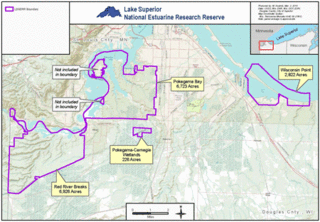
The Lake Superior National Estuarine Research Reserve includes land and water areas along the St. Louis River and Lake Superior in Douglas County, in the northwest corner of Wisconsin, United States. It is one of 29 National Estuarine Research Reserves. The Reserve is operated as a program of the Natural Resources Institute of the University of Wisconsin-Madison Division of Extension. It has an area of 16,697 acres (6,757 ha), and was designated in 2010.

The Wetlands Initiative (TWI) is a non-profit conservation organization headquartered in Chicago, Illinois, United States. The Wetlands Initiative works with nonprofit and government partners and local communities to advance wetland restoration and science in the Midwestern United States. The organizational vision of TWI is: "A world with plentiful healthy wetlands improving water quality, climate, biodiversity, and human well-being."

Prypiat-Stokhid National Nature Park was created in 2007 to protect and unify a series of natural complexes of the Pripyat River and Stokhid River valleys in northwestern Ukraine. The park provides protection, research areas, and recreation representative of the meadows and wetlands of the Polissia biosphere region. The park supports two Ramsar wetlands of international importance, and are joined in a cross-boundary Ramsar wetland with Belarus. The park is in the administrative district of Liubeshiv in Volyn Oblast.

Scioto Audubon Metro Park is a public park and nature preserve in Columbus, Ohio. The park is managed by the Columbus and Franklin County Metro Parks and is part of the Scioto Mile network of parks and trails around Downtown Columbus. The park features numerous trails, wetlands, rock climbing, volleyball and bocce courts, and numerous other amenities. At the western edge is the Grange Insurance Audubon Center, considered the first nature center built in close proximity to a downtown area.
