Oxbow lake

Last updated
This picture of the Nowitna River in Alaska shows two oxbow lakes - a short one at the bottom of the picture and a longer, more curved one at the middle-right. The picture also shows that a third oxbow lake is probably in the making: the isthmus or bank in the centre of the most prominent meander is very narrow - much narrower than the width of the river; eventually, the two sections of river on either side of an isthmus like that tend to break through and create a new, straighter course; a new river bank then starts to accumulate, sealing off the meander and leaving another oxbow lake. Nowitna river.jpg
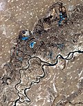
This picture of the Nowitna River in Alaska shows two oxbow lakes – a short one at the bottom of the picture and a longer, more curved one at the middle-right. The picture also shows that a third oxbow lake is probably in the making: the isthmus or bank in the centre of the most prominent meander is very narrow much narrower than the width of the river; eventually, the two sections of river on either side of an isthmus like that tend to break through and create a new, straighter course; a new river bank then starts to accumulate, sealing off the meander and leaving another oxbow lake.

An oxbow lake is a U-shaped lake or pool that forms when a wide meander of a river is cut off, creating a free-standing body of water. The word "oxbow" can also refer to a U-shaped bend in a river or stream, whether or not it is cut off from the main stream. [1] [2]

Contents

In South Texas, oxbows left by the Rio Grande are called resacas . In Australia, oxbow lakes are called billabongs.

Geology

A meander develops into an oxbow lake Meander Oxbow development.svg
A meander develops into an oxbow lake

An oxbow lake forms when a meandering river erodes through the neck of one of its meanders. This takes place because meanders tend to grow and become more curved over time. The river then follows a shorter course that bypasses the meander. [3] The entrances to the abandoned meander eventually silt up, forming an oxbow lake. [4] Because oxbow lakes are stillwater lakes, with no current flowing through them, the entire lake gradually silts up, becoming a bog or swamp and then evaporating completely. [3] [5] When a river reaches a low-lying plain, often in its final course to the sea or a lake, it meanders widely. In the vicinity of a river bend, deposition occurs on the convex bank (the bank with the smaller radius). In contrast, both lateral erosion and undercutting occur on the cut bank or concave bank (the bank with the greater radius). Continuous deposition on the convex bank and erosion of the concave bank of a meandering river cause the formation of a very pronounced meander with two concave banks getting closer. The narrow neck of land between the two neighboring concave banks is finally cut through, either by lateral erosion of the two concave banks or by the strong currents of a flood. When this happens a new, straighter river channel develops—and an abandoned meander loop, called a cutoff, forms. When deposition finally seals off the cutoff from the river channel, an oxbow lake forms. This process can occur over a time from a few years to several decades, and may sometimes become essentially static. [4]

Gathering of erosion products near the concave bank and transporting them to the convex bank is the work of the secondary flow across the floor of the river in the vicinity of a river bend. The process of deposition of silt, sand and gravel on the convex bank is clearly illustrated in point bars. [6]

The effect of the secondary flow can be demonstrated using a circular bowl. Partly fill the bowl with water and sprinkle dense particles such as sand or rice into the bowl. Set the water into circular motion with one hand or a spoon. The dense particles quickly sweep into a neat pile in the center of the bowl. This is the mechanism that leads to the formation of point bars and contributes to the formation of oxbow lakes. The primary flow of water in the bowl is circular and the streamlines are concentric with the side of the bowl. However, the secondary flow of the boundary layer across the floor of the bowl is inward toward the center. The primary flow might be expected to fling the dense particles to the perimeter of the bowl, but instead the secondary flow sweeps the particles toward the center. [7]

The curved path of a river around a bend makes the water's surface slightly higher on the outside of the bend than on the inside. As a result, at any elevation within the river, water pressure is slightly greater near the outside of the bend than on the inside. A pressure gradient toward the convex bank provides the centripetal force necessary for each parcel of water to follow its curved path.

The boundary layer that flows along the river floor does not move fast enough to balance the pressure gradient laterally across the river. It responds to this pressure gradient, and its velocity is partly downstream and partly across the river toward the convex bank. [6] [8] As it flows along the floor of the river, it sweeps loose material toward the convex bank. This flow of the boundary layer is significantly different from the speed and direction of the primary flow of the river, and is part of the river's secondary flow.

A Horseshoe or oxbow lake near Hughes, Arkansas. The bulges in the border reflect changes in the course of the river; when the river shifted its course and cut off the former channel, the border remained unchanged. Oxbow lake.jpg
A Horseshoe or oxbow lake near Hughes, Arkansas. The bulges in the border reflect changes in the course of the river; when the river shifted its course and cut off the former channel, the border remained unchanged.

River flood plains that contain rivers with a highly sinuous platform are populated by longer oxbow lakes than those with low sinuosity. This is because rivers with high sinuosity have larger meanders, and greater opportunity for longer lakes to form. Rivers with lower sinuosity are characterized by fewer cutoffs and shorter oxbow lakes due to the shorter distance of their meanders. [9]

Oxbow lake ecology

Oxbow lakes on New Zealand's Taieri River have been converted into water meadows. Red Deer on the Upper Taieri Watermeadow - panoramio.jpg
Oxbow lakes on New Zealand's Taieri River have been converted into water meadows.

Oxbow lakes form favorable habitats for wildlife communities. These often have unique characteristics. For example, the numerous oxbow lakes of the Amazon River are a favorable habitat for the giant river otter. [3] Oxbow lakes may also be suitable locations for aquaculture. [10]

Oxbow lakes contribute to the health of a river ecosystem by trapping sediments and agricultural runoff, thereby removing them from the main river flow. However, this is destructive of the oxbow lake ecosystem itself. [11] Oxbow lakes are also vulnerable to heavy metal contamination from industrial sources. [12]

Artificial oxbow lakes

Oxbow lakes may be formed when a river channel is straightened artificially to improve navigation or for flood alleviation. This occurred notably on the upper Rhine in Germany in the nineteenth century. [13]

An example of an entirely artificial waterway with oxbows is the Oxford Canal in England. When originally constructed, it had a very meandering course, following the contours of the land, but the northern part of the canal was straightened out between 1829 and 1834, reducing its length from approximately 146 to 125 km (91 to 77+12 mi) and creating a number of oxbow-shaped sections isolated from the new course. [14]

Notable examples

There has also been a possible oxbow lake postulated in Saraswati Flumen near Ontario Lacus on Saturn's moon Titan. [15]

See also

Related Research Articles

<span class="mw-page-title-main">Erosion</span> Natural processes that remove soil and rock

Erosion is the action of surface processes that removes soil, rock, or dissolved material from one location on the Earth's crust and then transports it to another location where it is deposited. Erosion is distinct from weathering which involves no movement. Removal of rock or soil as clastic sediment is referred to as physical or mechanical erosion; this contrasts with chemical erosion, where soil or rock material is removed from an area by dissolution. Eroded sediment or solutes may be transported just a few millimetres, or for thousands of kilometres.

<span class="mw-page-title-main">Sediment</span> Particulate solid matter that is deposited on the surface of land

Sediment is a naturally occurring material that is broken down by processes of weathering and erosion, and is subsequently transported by the action of wind, water, or ice or by the force of gravity acting on the particles. For example, sand and silt can be carried in suspension in river water and on reaching the sea bed deposited by sedimentation; if buried, they may eventually become sandstone and siltstone through lithification.

<span class="mw-page-title-main">Floodplain</span> Land adjacent to a river which is flooded during periods of high discharge

A floodplain or flood plain or bottomlands is an area of land adjacent to a river. Floodplains stretch from the banks of a river channel to the base of the enclosing valley, and experience flooding during periods of high discharge. The soils usually consist of clays, silts, sands, and gravels deposited during floods.

<span class="mw-page-title-main">Braided river</span> Network of river channels separated by small, and often temporary, islands

A braided river consists of a network of river channels separated by small, often temporary, islands called braid bars or, in British English usage, aits or eyots.

<span class="mw-page-title-main">Fluvial sediment processes</span> Sediment processes associated with rivers and streams

In geography and geology, fluvial sediment processes or fluvial sediment transport are associated with rivers and streams and the deposits and landforms created by sediments. It can result in the formation of ripples and dunes, in fractal-shaped patterns of erosion, in complex patterns of natural river systems, and in the development of floodplains and the occurrence of flash floods. Sediment moved by water can be larger than sediment moved by air because water has both a higher density and viscosity. In typical rivers the largest carried sediment is of sand and gravel size, but larger floods can carry cobbles and even boulders. When the stream or rivers are associated with glaciers, ice sheets, or ice caps, the term glaciofluvial or fluvioglacial is used, as in periglacial flows and glacial lake outburst floods. Fluvial sediment processes include the motion of sediment and erosion or deposition on the river bed.

Landforms are categorized by characteristic physical attributes such as their creating process, shape, elevation, slope, orientation, rock exposure, and soil type.

<span class="mw-page-title-main">Stream bed</span> Channel bottom of a stream, river, or creek

A streambed or stream bed is the bottom of a stream or river (bathymetry) and is confined within a channel, or the banks (bank of the waterway. Usually the bed does not contain terrestrial vegetation and instead supports different types of aquatic vegetation, depending on the type of streambed material and water velocity. Streambeds are what would be left once a stream is no longer in existence. The beds are usually well preserved even if they get buried because the banks and canyons made by the stream are typically hard, although soft sand and debris often fill the bed. Dry, buried streambeds can actually be underground water pockets. During times of rain, sandy streambeds can soak up and retain water, even during dry seasons, keeping the water table close enough to the surface to be obtainable by local people.

<span class="mw-page-title-main">Meander</span> One of a series of curves in a channel of a matured stream

A meander is one of a series of regular sinuous curves in the channel of a river or other watercourse. It is produced as a watercourse erodes the sediments of an outer, concave bank and deposits sediments on an inner, convex bank which is typically a point bar. The result of this coupled erosion and sedimentation is the formation of a sinuous course as the channel migrates back and forth across the axis of a floodplain.

<span class="mw-page-title-main">Point bar</span> Landform related to streams and rivers

A point bar is a depositional feature made of alluvium that accumulates on the inside bend of streams and rivers below the slip-off slope. Point bars are found in abundance in mature or meandering streams. They are crescent-shaped and located on the inside of a stream bend, being very similar to, though often smaller than, towheads, or river islands.

<span class="mw-page-title-main">Cut bank</span> Outside bank of a water channel, which is continually undergoing erosion

A cut bank, also known as a river cliff or river-cut cliff, is the outside bank of a curve (meander) in a water channel (stream), which is continually undergoing erosion. Cut banks are found in abundance along mature or meandering streams, they are located opposite the slip-off slope on the inside of the stream meander. They are shaped much like a small cliff, and are formed as the stream collides with the river bank. It is the opposite of a point bar, which is an area of deposition of material eroded upstream in a cut bank.

In fluid dynamics, flow can be decomposed into primary flow plus secondary flow, a relatively weaker flow pattern superimposed on the stronger primary flow pattern. The primary flow is often chosen to be an exact solution to simplified or approximated governing equations, such as potential flow around a wing or geostrophic current or wind on the rotating Earth. In that case, the secondary flow usefully spotlights the effects of complicated real-world terms neglected in those approximated equations. For instance, the consequences of viscosity are spotlighted by secondary flow in the viscous boundary layer, resolving the tea leaf paradox. As another example, if the primary flow is taken to be a balanced flow approximation with net force equated to zero, then the secondary circulation helps spotlight acceleration due to the mild imbalance of forces. A smallness assumption about secondary flow also facilitates linearization.

Abyssal channels are channels in Earth's sea floor. They are formed by fast-flowing floods of turbid water caused by avalanches near the channel's head, with the sediment carried by the water causing a build-up of the surrounding abyssal plains. Submarine channels and the turbidite systems which form them are responsible for the accumulation of most sandstone deposits found on continental slopes and have proven to be one of the most common types of hydrocarbon reservoirs found in these regions.

<span class="mw-page-title-main">Backswamp</span> Environment on a floodplain where deposits settle after a flood

In geology, a backswamp is a type of depositional environment commonly found in a floodplain. It is where deposits of fine silts and clays settle after a flood. These deposits create a marsh-like landscape that is often poorly drained and usually lower than the rest of the floodplain.

<span class="mw-page-title-main">Avulsion (river)</span> Rapid abandonment of a river channel and formation of a new channel

In sedimentary geology and fluvial geomorphology, avulsion is the rapid abandonment of a river channel and the formation of a new river channel. Avulsions occur as a result of channel slopes that are much less steep than the slope that the river could travel if it took a new course.

<span class="mw-page-title-main">Tea leaf paradox</span> Fluid dynamics phenomenon

In fluid dynamics, the tea leaf paradox is a phenomenon where tea leaves in a cup of tea migrate to the center and bottom of the cup after being stirred rather than being forced to the edges of the cup, as would be expected in a spiral centrifuge.

<span class="mw-page-title-main">Bar (river morphology)</span> Elevated region of sediment in a river that has been deposited by the flow

A bar in a river is an elevated region of sediment that has been deposited by the flow. Types of bars include mid-channel bars, point bars, and mouth bars. The locations of bars are determined by the geometry of the river and the flow through it. Bars reflect sediment supply conditions, and can show where sediment supply rate is greater than the transport capacity.

River channel migration is the geomorphological process that involves the lateral migration of an alluvial river channel across its floodplain. This process is mainly driven by the combination of bank erosion of and point bar deposition over time. When referring to river channel migration, it is typically in reference to meandering streams. In braided streams, channel change is driven by sediment transport.

<span class="mw-page-title-main">Alluvial river</span> Type of river

An alluvial river is one in which the bed and banks are made up of mobile sediment and/or soil. Alluvial rivers are self-formed, meaning that their channels are shaped by the magnitude and frequency of the floods that they experience, and the ability of these floods to erode, deposit, and transport sediment. For this reason, alluvial rivers can assume a number of forms based on the properties of their banks; the flows they experience; the local riparian ecology; and the amount, size, and type of sediment that they carry.

<span class="mw-page-title-main">Meander cutoff</span>

A meander cutoff is a natural form of a cutting or cut in a river occurs when a pronounced meander (hook) in a river is breached by a flow that connects the two closest parts of the hook to form a new channel, a full loop. The steeper drop in gradient (slope) causes the river flow gradually to abandon the meander which will silt up with sediment from deposition. Cutoffs are a natural part of the evolution of a meandering river. Rivers form meanders as they flow laterally downstream, see sinuosity.

<span class="mw-page-title-main">Slip-off slope</span> Depositional landform on the inside convex bank of a meandering river

A slip-off slope is a depositional landform that occurs on the inside convex bank of a meandering river. The term can refer to two different features: one in a freely meandering river with a floodplain and the other in an entrenched river.

References

  1. "Oxbow". Oxford English Dictionary. Archived from the original on September 30, 2007. Retrieved 2009-10-27.
  2. "Oxbow". Merriam–Webster . Retrieved 2009-10-27.
  3. 1 2 3 Rutledge, Kim; Ramroop, Tara; Boudreau, Diane; McDaniel, Melissa; Teng, Santani; Sprout, Erin; Costa, Hilary; Hall, Hilary; Hunt, Jeff (10 June 2011). "Oxbow lake". National Geographic. Retrieved 26 September 2021.
  4. 1 2 Constantine, José Antonio; Dunne, Thomas; Piégay, Hervé; Mathias Kondolf, G. (February 2010). "Controls on the alluviation of oxbow lakes by bed-material load along the Sacramento River, California". Sedimentology. 57 (2): 389–407. Bibcode:2010Sedim..57..389C. doi:10.1111/j.1365-3091.2009.01084.x. S2CID   129166672.
  5. Kirschner, Alexander K. T.; Riegl, Bernhard; Velimirov, Branko (2001). "Degradation of Emergent and Submerged Macrophytesin an Oxbow Lake of an Embanked Backwater System: Implications for the Terrestrialization Process". International Review of Hydrobiology. 86 (4–5): 555–571. doi:10.1002/1522-2632(200107)86:4/5<555::AID-IROH555>3.0.CO;2-9.
  6. 1 2 Hickin, Edward J (2002). "Meandering Channels". In Middleton, Gerard V. (ed.). Encyclopedia of Sediments and Sedimentary Rocks. New York: Springer. p. 432. ISBN   1-4020-0872-4.
  7. Bowker, Kent A. (1988). "Albert Einstein and Meandering Rivers". Earth Science History. 1 (1): 45. Bibcode:1988ESHis...7...45B. doi:10.17704/eshi.7.1.yk72n55q84qxu5n6 . Retrieved 2016-07-01.
  8. Chant, R. J. (2002). "Secondary circulation in a region of flow curvature: Relationship with tidal forcing and river discharge". Journal of Geophysical Research. 107 (C9): 14-1–14-11. Bibcode:2002JGRC..107.3131C. doi:10.1029/2001JC001082.
  9. Constantine, J. A.; Dunne, T. (2008). "Meander cutoff and the controls on the production of oxbow lakes". Geology. 36 (1): 23–26. Bibcode:2008Geo....36...23C. doi:10.1130/G24130A.1.
  10. Gupta, S.; Devi, S.S. (2014). "Ecology of Baskandi anua, an oxbow lake of South Assam, North East India". Journal of Environmental Biology. 35 (6): 1101–1105. PMID   25522512 . Retrieved 26 September 2021.
  11. Glińska-Lewczuk, Katarzyna (2005). "Oxbow lakes as biogeochemical filters for nutrient outflow from agricultural areas". Dynamics and Biogeochemistry of River Corridors and Wetlands. 294: 55–69. Retrieved 26 September 2021.
  12. Ciazela, Jakub; Siepak, Marcin; Wojtowicz, Piotr (March 2018). "Tracking heavy metal contamination in a complex river-oxbow lake system: Middle Odra Valley, Germany/Poland". Science of the Total Environment. 616–617: 996–1006. Bibcode:2018ScTEn.616..996C. doi:10.1016/j.scitotenv.2017.10.219. PMID   29103644.
  13. Zinke, Alexander (December 17, 2000). "The New Management of Rivers and Wetlands in Central Europe". Zinke Environmental Consulting. Retrieved 2009-10-27.
  14. Boughey, Joseph (1994). Hadfield's British Canals. Sutton Publishing. ISBN   0-7509-1840-3.
  15. Dhingra, Rajani D.; Barnes, Jason W.; Yanites, Brian J.; Kirk, Randolph L. (2018-01-01). "Large catchment area recharges Titan's Ontario Lacus". Icarus. 299: 331–338. Bibcode:2018Icar..299..331D. doi:10.1016/j.icarus.2017.08.009. ISSN   0019-1035.