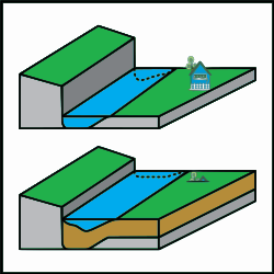
Aggradation

Last updated
Schematic of sediment accumulation (aggradation) in a river channel. The sediment is brown. The river is flowing on bedrock in the upper image, but because sediment was deposited over time the riverbed has risen. This has caused the house to be buried in the lower image. Aggradation.png
Schematic of sediment accumulation (aggradation) in a river channel. The sediment is brown. The river is flowing on bedrock in the upper image, but because sediment was deposited over time the riverbed has risen. This has caused the house to be buried in the lower image.

Aggradation (or alluviation) is the term used in geology for the increase in land elevation, typically in a river system, due to the deposition of sediment. Aggradation occurs in areas in which the supply of sediment is greater than the amount of material that the system is able to transport. The mass balance between sediment being transported and sediment in the bed is described by the Exner equation.

Contents

Typical aggradational environments include lowland alluvial rivers, river deltas, and alluvial fans. Aggradational environments are often undergoing slow subsidence which balances the increase in land surface elevation due to aggradation. After millions of years, an aggradational environment will become a sedimentary basin, which contains the deposited sediment, including paleochannels and ancient floodplains.

Aggradation can be caused by changes in climate, land use, and geologic activity, such as volcanic eruption, earthquakes, and faulting. For example, volcanic eruptions may lead to rivers carrying more sediment than the flow can transport: this leads to the burial of the old channel and its floodplain. In another example, the quantity of sediment entering a river channel may increase when climate becomes drier. The increase in sediment is caused by a decrease in soil binding that results from plant growth being suppressed. The drier conditions cause river flow to decrease at the same time as sediment is being supplied in greater quantities, resulting in the river becoming choked with sediment.

In 2009, a report by researchers from the University of Colorado at Boulder in the journal Nature Geoscience said that reduced aggradation was contributing to an increased risk of flooding in many river deltas. [1]

See also

Related Research Articles

<span class="mw-page-title-main">Sedimentary rock</span> Rock formed by the deposition and cementation of particles

Sedimentary rocks are types of rock that are formed by the accumulation or deposition of mineral or organic particles at Earth's surface, followed by cementation. Sedimentation is the collective name for processes that cause these particles to settle in place. The particles that form a sedimentary rock are called sediment, and may be composed of geological detritus (minerals) or biological detritus. The geological detritus originated from weathering and erosion of existing rocks, or from the solidification of molten lava blobs erupted by volcanoes. The geological detritus is transported to the place of deposition by water, wind, ice or mass movement, which are called agents of denudation. Biological detritus was formed by bodies and parts of dead aquatic organisms, as well as their fecal mass, suspended in water and slowly piling up on the floor of water bodies. Sedimentation may also occur as dissolved minerals precipitate from water solution.

<span class="mw-page-title-main">Braided river</span> Network of river channels

A braided river consists of a network of river channels separated by small, often temporary, islands called braid bars or, in British English usage, aits or eyots.

<span class="mw-page-title-main">River delta</span> Silt deposition landform at the mouth of a river

A river delta is a landform shaped like a triangle, created by the deposition of sediment that is carried by a river and enters slower-moving or stagnant water. This occurs at a river mouth, when it enters an ocean, sea, estuary, lake, reservoir, or another river that cannot carry away the supplied sediment. It is so named because its triangle shape resembles the uppercase Greek letter delta, Δ. The size and shape of a delta are controlled by the balance between watershed processes that supply sediment, and receiving basin processes that redistribute, sequester, and export that sediment. The size, geometry, and location of the receiving basin also plays an important role in delta evolution.

<span class="mw-page-title-main">Alluvium</span> Loose soil or sediment that is eroded and redeposited in a non-marine setting

Alluvium is loose clay, silt, sand, or gravel that has been deposited by running water in a stream bed, on a floodplain, in an alluvial fan or beach, or in similar settings. Alluvium is also sometimes called alluvial deposit. Alluvium is typically geologically young and is not consolidated into solid rock. Sediments deposited underwater, in seas, estuaries, lakes, or ponds, are not described as alluvium.

<span class="mw-page-title-main">Alluvial fan</span> Fan-shaped deposit of sediment

An alluvial fan is an accumulation of sediments that fans outwards from a concentrated source of sediments, such as a narrow canyon emerging from an escarpment. They are characteristic of mountainous terrain in arid to semiarid climates, but are also found in more humid environments subject to intense rainfall and in areas of modern glaciation. They range in area from less than 1 square kilometer (0.4 sq mi) to almost 20,000 square kilometers (7,700 sq mi).

<span class="mw-page-title-main">Fluvial sediment processes</span> Sediment processes associated with rivers and streams

In geography and geology, fluvial sediment processes or fluvial sediment transport are associated with rivers and streams and the deposits and landforms created by sediments. It can result in the formation of ripples and dunes, in fractal-shaped patterns of erosion, in complex patterns of natural river systems, and in the development of floodplains and the occurrence of flash floods. Sediment moved by water can be larger than sediment moved by air because water has both a higher density and viscosity. In typical rivers the largest carried sediment is of sand and gravel size, but larger floods can carry cobbles and even boulders. When the stream or rivers are associated with glaciers, ice sheets, or ice caps, the term glaciofluvial or fluvioglacial is used, as in periglacial flows and glacial lake outburst floods. Fluvial sediment processes include the motion of sediment and erosion or deposition on the river bed.

Landforms are categorized by characteristic physical attributes such as their creating process, shape, elevation, slope, orientation, rock exposure, and soil type.

Retrogradation is the landward change in position of the front of a river delta with time. This occurs when the mass balance of sediment into the delta is such that the volume of incoming sediment is less than the volume of the delta that is lost through subsidence, sea-level rise, and/or erosion. As a result, retrogradation is most common:

<span class="mw-page-title-main">Kobuk River</span> River in the U.S. state of Alaska

The Kobuk River, also known by the names Kooak, Kowak, Kubuk, Kuvuk, and Putnam, is a river located in the Arctic region of northwestern Alaska in the United States. It is approximately 280 miles (451 km) long. Draining a basin with an area of 12,300 square miles (32,000 km2), the Kobuk River is among the largest rivers in northwest Alaska, with widths of up to 1,500 feet and flows reaching speeds of 3–5 miles per hour in its lower and middle reaches. The average elevation for the Kobuk River Basin is 1,300 feet (400 m) above sea level, ranging from sea level at its mouth on the Bering Sea to 11,400 feet near its headwaters in the Brooks Range.

<span class="mw-page-title-main">Alluvial plain</span> Region on which rivers have deposited sediment

An alluvial plain is a plain created by the deposition of sediment over a long period of time by one or more rivers coming from highland regions, from which alluvial soil forms. A floodplain is part of the process, being the smaller area over which the rivers flood at a particular period of time, whereas the alluvial plain is the larger area representing the region over which the floodplains have shifted over geological time.

<span class="mw-page-title-main">Sedimentation</span> Tendency for particles in suspension to settle down

Sedimentation is the deposition of sediments. It takes place when particles in suspension settle out of the fluid in which they are entrained and come to rest against a barrier. This is due to their motion through the fluid in response to the forces acting on them: these forces can be due to gravity, centrifugal acceleration, or electromagnetism. Settling is the falling of suspended particles through the liquid, whereas sedimentation is the final result of the settling process.

<span class="mw-page-title-main">Polystrate fossil</span> Creationist term for a fossil that extends through more than one geological stratum

A polystrate fossil is a fossil of a single organism that extends through more than one geological stratum. The word polystrate is not a standard geological term. This term is typically found in creationist publications.

<span class="mw-page-title-main">Depression (geology)</span> Landform sunken or depressed below the surrounding area

In geology, a depression is a landform sunken or depressed below the surrounding area. Depressions form by various mechanisms.

<span class="mw-page-title-main">Palaeochannel</span> An inactive river or stream channel that has been filled or buried

In the Earth sciences, a palaeochannel, also spelled paleochannel, is a significant length of a river or stream channel which no longer conveys fluvial discharge as part of an active fluvial system. The term palaeochannel is derived from the combination of two words, palaeo or old, and channel; i.e., a palaeochannel is an old channel. Palaeochannels may be preserved either as abandoned surface channels on the surface of river floodplains and terraces or infilled and partially or fully buried by younger sediments. The fill of a palaeochannel and its enclosing sedimentary deposits may consist of unconsolidated, semi-consolidated, or well-cemented sedimentary strata depending on the action of tectonics and diagenesis during their geologic history after deposition. The abandonment of an active fluvial channel and the resulting formation of a palaeochannel can be the result of tectonic processes, geomorphologic processes, anthropogenic activities, climatic changes, or a variable and interrelated combination of these factors.

<span class="mw-page-title-main">Avulsion (river)</span> Rapid abandonment of a river channel and formation of a new channel

In sedimentary geology and fluvial geomorphology, avulsion is the rapid abandonment of a river channel and the formation of a new river channel. Avulsions occur as a result of channel slopes that are much less steep than the slope that the river could travel if it took a new course.

<span class="mw-page-title-main">Coyote Mountains</span> Mountain range in California, United States

The Coyote Mountains are a small mountain range in San Diego and Imperial Counties in southern California. The Coyotes form a narrow ESE trending 2 mi (3.2 km) wide range with a length of about 12 mi (19 km). The southeast end turns and forms a 2 mi (3.2 km) north trending "hook". The highest point is Carrizo Mountain on the northeast end with an elevation of 2,408 feet (734 m). Mine Peak at the northwest end of the range has an elevation of 1,850 ft (560 m). Coyote Wash along I-8 along the southeast margin of the range is 100 to 300 feet in elevation. Plaster City lies in the Yuha Desert about 5.5 mi (8.9 km) east of the east end of the range.

In sedimentary geology and geomorphology, the term progradation refers to the growth of a river delta farther out into the sea over time. This occurs when the volume of incoming sediment is greater than the volume of the delta that is lost through subsidence, sea-level rise, or erosion.

<span class="mw-page-title-main">Alluvial river</span> Type of river

An alluvial river is one in which the bed and banks are made up of mobile sediment and/or soil. Alluvial rivers are self-formed, meaning that their channels are shaped by the magnitude and frequency of the floods that they experience, and the ability of these floods to erode, deposit, and transport sediment. For this reason, alluvial rivers can assume a number of forms based on the properties of their banks; the flows they experience; the local riparian ecology; and the amount, size, and type of sediment that they carry.

Tectonic subsidence is the sinking of the Earth's crust on a large scale, relative to crustal-scale features or the geoid. The movement of crustal plates and accommodation spaces produced by faulting brought about subsidence on a large scale in a variety of environments, including passive margins, aulacogens, fore-arc basins, foreland basins, intercontinental basins and pull-apart basins. Three mechanisms are common in the tectonic environments in which subsidence occurs: extension, cooling and loading.

The Aksu Basin is a sedimentary basin in southwestern Turkey, around the present-day Aksu River. Located at the intersection of several major tectonic systems, in the Isparta Angle, the Aksu Basin covers an area of some 2000 square kilometers. Together with the Köprü Çay Basin and the Manavgat Basin, the Aksu Basin forms part of the broader Antalya Basin. It forms a graben relative to the surrounding Anatolian plateau.

References

  1. Black, Richard (2009-09-21). "'Millions at risk' as deltas sink". BBC News Online . Retrieved 2009-09-23.