Bar (river morphology)

Last updated
Point bar at a river meander: the Cirque de la Madeleine in the Gorges de l'Ardeche, France. CirqueMadeleine.jpg
Point bar at a river meander: the Cirque de la Madeleine in the Gorges de l'Ardèche, France.
Gravel bar in the American River, Washington, United States. American River 16792.JPG
Gravel bar in the American River, Washington, United States.

A bar in a river is an elevated region of sediment (such as sand or gravel) that has been deposited by the flow. Types of bars include mid-channel bars (also called braid bars and common in braided rivers), point bars (common in meandering rivers), and mouth bars (common in river deltas). The locations of bars are determined by the geometry of the river and the flow through it. Bars reflect sediment supply conditions, and can show where sediment supply rate is greater than the transport capacity.

Contents

A mid-channel bar, is also often referred to as a braid bar because they are often found in braided river channels. Braided river channels are broad and shallow and found in areas where sediment is easily eroded like at a glacial outwash, or at a mountain front with high sediment loads. [1] [2] These types of river systems are associated with high slope, sediment supply, stream power, shear stress, and bed load transport rates. [2] Braided rivers have complex and unpredictable channel patterns, and sediment size tends to vary among streams. [3] It is these features that are responsible for the formations of braid bars. Braided streams are often overfed with massive amounts of sediment which creates multiple stream channels within one dominant pair of flood bank plains. [2] These channels are separated by mid-channel or braid bars. Anastomosing river channels also create mid-channel bars, however they are typically vegetated bars, making them more permanent than the bars found in a braided river channel which have high rates of change because of the large amounts of non-cohesive sediment, lack of vegetation, and high stream powers found in braided river channels. [3] [1]

Bars can also form mid-channel due to snags or logjams. For example, if a stable log is deposited mid-channel in a stream, this obstructs the flow and creates local flow convergence and divergence. [1] This causes erosion on the upstream side of the obstruction and deposition on the downstream side. The deposition that occurs on the downstream side can create a central bar, and an arcuate bar can be formed as flow diverges upstream of the obstruction. [1] Continuous deposition downstream can build up the central bar to form an island. Eventually the logjam can become partially buried, which protects the island from erosion, allowing for vegetation to begin to grow, and stabilize the area even further. Over time, the bar can eventually attach to one side of the channel bank and merge into the flood plain. [1]

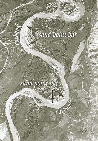
A point bar is an area of deposition typically found in meandering rivers. Point bars form on the inside of meander bends in meandering rivers. As the flow moves around the inside of the bend in the river, the water slows down because of the shallow flow and low shear stresses there reduce the amount of material that can be carried there. Point bars are usually crescent shaped and located on the inside curve of the river bend. [4] The excess material falls out of transport and, over time, forms a point bar. Point bars are typically found in the slowest moving, shallowest parts of rivers and streams, [5] and are often parallel to the shore and occupy the area farthest from the thalweg, [6] on the outside curve of the river bend in a meandering river. Here, at the deepest and fastest part of the stream is the cut bank, the area of a meandering river channel that continuously undergoes erosion. [4] The faster the water in a river channel, the better it is able to pick up greater amounts of sediment, and larger pieces of sediment, which increases the river's bed load. [4] Over a long enough period of time, the combination of deposition along point bars, and erosion along cut banks can lead to the formation of an oxbow lake. [1]

A mouth bar is an elevated region of sediment typically found at a river delta which is located at the mouth of a river where the river flows out to the ocean. Sediment is transported by the river and deposited, mid channel, at the mouth of the river. This occurs because, as the river widens at the mouth, the flow slows, and sediment settles out and is deposited. [7] After initial formation of a river mouth bar, they have the tendency to prograde. [7] This is caused by the pressure from the flow on the upstream face of the bar. This pressure creates erosion on that face of the bar, allowing the flow to transport this sediment over or around, and re-deposit it farther downstream, closer to the ocean. [7] River mouth bars stagnate, or cease to prograde when the water depth above the flow is shallow enough to create a pressure on the upstream side of the bar strong enough to force the flow around the deposit rather than over the top of the bar. [7] This divergent channel flow around either side of the sediment deposit continuously transports sediment, which over time is deposited on either side of this original mid channel deposit. As more and more sediment accumulates across the mouth of the river, it builds up to eventually create a sand bar that has the potential to extend the entire length of the river mouth and block the flow.

See also

Related Research Articles

<span class="mw-page-title-main">Sediment</span> Particulate solid matter that is deposited on the surface of land

Sediment is a naturally occurring material that is broken down by processes of weathering and erosion, and is subsequently transported by the action of wind, water, or ice or by the force of gravity acting on the particles. For example, sand and silt can be carried in suspension in river water and on reaching the sea bed deposited by sedimentation; if buried, they may eventually become sandstone and siltstone through lithification.

<span class="mw-page-title-main">Braided river</span> Network of river channels separated by small, and often temporary, islands

A braided river consists of a network of river channels separated by small, often temporary, islands called braid bars or, in British English usage, aits or eyots.

<span class="mw-page-title-main">Fluvial processes</span> Processes associated with rivers and streams

In geography and geology, fluvial processes are associated with rivers and streams and the deposits and landforms created by them. When the stream or rivers are associated with glaciers, ice sheets, or ice caps, the term glaciofluvial or fluvioglacial is used.

Landforms are categorized by characteristic physical attributes such as their creating process, shape, elevation, slope, orientation, rock exposure, and soil type.

<span class="mw-page-title-main">Meander</span> One of a series of curves in a channel of a matured stream

A meander is one of a series of regular sinuous curves in the channel of a river or other watercourse. It is produced as a watercourse erodes the sediments of an outer, concave bank and deposits sediments on an inner, convex bank which is typically a point bar. The result of this coupled erosion and sedimentation is the formation of a sinuous course as the channel migrates back and forth across the axis of a floodplain.

The terms river morphology and its synonym stream morphology are used to describe the shapes of river channels and how they change in shape and direction over time. The morphology of a river channel is a function of a number of processes and environmental conditions, including the composition and erodibility of the bed and banks ; erosion comes from the power and consistency of the current, and can effect the formation of the river's path. Also, vegetation and the rate of plant growth; the availability of sediment; the size and composition of the sediment moving through the channel; the rate of sediment transport through the channel and the rate of deposition on the floodplain, banks, bars, and bed; and regional aggradation or degradation due to subsidence or uplift. River morphology can also be affected by human interaction, which is a way the river responds to a new factor in how the river can change its course. An example of human induced change in river morphology is dam construction, which alters the ebb flow of fluvial water and sediment, therefore creating or shrinking estuarine channels. A river regime is a dynamic equilibrium system, which is a way of classifying rivers into different categories. The four categories of river regimes are Sinuous canali- form rivers, Sinuous point bar rivers, Sinuous braided rivers, and Non-sinuous braided rivers.

<span class="mw-page-title-main">River bifurcation</span> The forking of a river into its distributaries

River bifurcation occurs when a river flowing in a single stream separates into two or more separate streams which then continue downstream. Some rivers form complex networks of distributaries, typically in their deltas. If the streams eventually merge again or empty into the same body of water, then the bifurcation forms a river island.

<span class="mw-page-title-main">Cross-bedding</span> Sedimentary rock strata at differing angles

In geology, cross-bedding, also known as cross-stratification, is layering within a stratum and at an angle to the main bedding plane. The sedimentary structures which result are roughly horizontal units composed of inclined layers. The original depositional layering is tilted, such tilting not being the result of post-depositional deformation. Cross-beds or "sets" are the groups of inclined layers, which are known as cross-strata.

<span class="mw-page-title-main">Point bar</span> Landform related to streams and rivers

A point bar is a depositional feature made of alluvium that accumulates on the inside bend of streams and rivers below the slip-off slope. Point bars are found in abundance in mature or meandering streams. They are crescent-shaped and located on the inside of a stream bend, being very similar to, though often smaller than, towheads, or river islands.

<span class="mw-page-title-main">Stream load</span>

Stream load is a geologic term referring to the solid matter carried by a stream. Erosion and bed shear stress continually remove mineral material from the bed and banks of the stream channel, adding this material to the regular flow of water. The amount of solid load that a stream can carry, or stream capacity, is measured in metric tons per day, passing a given location. Stream capacity is dependent upon the stream's velocity, the amount of water flow, and the gradation.

<span class="mw-page-title-main">River</span> Natural flowing watercourse

A river is a natural flowing watercourse, usually a freshwater stream, flowing on the earth's land surface or inside caves towards another waterbody at a lower elevation, such as an ocean, sea, bay, lake, wetland, or another river. In some cases, a river flows into the ground or becomes dry at the end of its course without reaching another body of water. Small rivers can be referred to by names such as creek, brook, and rivulet. There are no official definitions for the generic term river as applied to geographic features, although in some countries or communities, a stream is defined by its size. Many names for small rivers are specific to geographic location; examples are "run" in some parts of the United States, "burn" in Scotland and Northeast England, and "beck" in Northern England. Sometimes a river is defined as being larger than a creek, but not always; the language is vague.

<span class="mw-page-title-main">Avulsion (river)</span> Rapid abandonment of a river channel and formation of a new channel

In sedimentary geology and fluvial geomorphology, avulsion is the rapid abandonment of a river channel and the formation of a new river channel. Avulsions occur as a result of channel slopes that are much less steep than the slope that the river could travel if it took a new course.

River channel migration is the geomorphological process that involves the lateral migration of an alluvial river channel across its floodplain. This process is mainly driven by the combination of bank erosion of and point bar deposition over time. When referring to river channel migration, it is typically in reference to meandering streams. In braided streams, channel change is driven by sediment transport.

A mouth bar is an element of a deltaic system, which refers to the typically mid-channel deposition of the sediment transported by the river channel at the river mouth.

<span class="mw-page-title-main">Alluvial river</span> Type of river

An alluvial river is one in which the bed and banks are made up of mobile sediment and/or soil. Alluvial rivers are self-formed, meaning that their channels are shaped by the magnitude and frequency of the floods that they experience, and the ability of these floods to erode, deposit, and transport sediment. For this reason, alluvial rivers can assume a number of forms based on the properties of their banks; the flows they experience; the local riparian ecology; and the amount, size, and type of sediment that they carry.

Channel patterns are found in rivers, streams, and other bodies of water that transport water from one place to another. Systems of branching river channels dissect most of the sub-aerial landscape, each in a valley proportioned to its size. Whether formed by chance or necessity, by headward erosion or downslope convergence, whether inherited or newly formed. Depending on different geological factors such as weathering, erosion, depositional environment, and sediment type, different types of channel patterns can form.

<span class="mw-page-title-main">Braid bar</span> Depositional landform in a river which splits a channel

Braid bars, or mid-channel bars, are river landforms typically present in braided river channels. These formations have many names, including medial, longitudinal, crescentic, and transverse bars, as well as the more colloquial sandflat. Braid bars are distinguished from point bars due to their presence in the middle of a flow channel, rather than along a bank of the river channel.

<span class="mw-page-title-main">Meander cutoff</span>

A meander cutoff is a natural form of a cutting or cut in a river occurs when a pronounced meander (hook) in a river is breached by a flow that connects the two closest parts of the hook to form a new channel, a full loop. The steeper drop in gradient (slope) causes the river flow gradually to abandon the meander which will silt up with sediment from deposition. Cutoffs are a natural part of the evolution of a meandering river. Rivers form meanders as they flow laterally downstream, see sinuosity.

<span class="mw-page-title-main">Slip-off slope</span> Depositional landform on the inside convex bank of a meandering river

A slip-off slope is a depositional landform that occurs on the inside convex bank of a meandering river. The term can refer to two different features: one in a freely meandering river with a floodplain and the other in an entrenched river.

<span class="mw-page-title-main">Glaciofluvial deposits</span> Sediments/deposits formed from ice sheets or glaciers

Glaciofluvial deposits or Glacio-fluvial sediments consist of boulders, gravel, sand, silt and clay from ice sheets or glaciers. They are transported, sorted and deposited by streams of water. The deposits are formed beside, below or downstream from the ice. They include kames, kame terraces and eskers formed in ice contact and outwash fans and outwash plains below the ice margin. Typically the outwash sediment is carried by fast and turbulent fluvio-glacial meltwater streams, but occasionally it is carried by catastrophic outburst floods. Larger elements such as boulders and gravel are deposited nearer to the ice margin, while finer elements are carried farther, sometimes into lakes or the ocean. The sediments are sorted by fluvial processes. They differ from glacial till, which is moved and deposited by the ice of the glacier, and is unsorted.

References

  1. 1 2 3 4 5 6 Bierman and Montgomery. Key Concepts in Geomorphology. Freeman and co. publishing.
  2. 1 2 3 Wooster, John. "A Braided River System in a Glacial Environment, the Copper River, Alaska" (PDF). Archived from the original (PDF) on 12 June 2010. Retrieved 11 May 2017.
  3. 1 2 Schuurman, Filip; Marra, Wouter A.; Kleinhans, Maarten G. (2013). "Physics-based modeling of large braided sand-bed rivers: Bar pattern formation, dynamics, and sensitivity". Journal of Geophysical Research: Earth Surface. 118 (4): 2509–2527. Bibcode:2013JGRF..118.2509S. doi: 10.1002/2013JF002896 . S2CID   130287778.
  4. 1 2 3 foxult. "Thalwegs, Point Bars, & Cut Banks (Oh my!)" . Retrieved 11 May 2017.
  5. Strahler, Alan; Strahler, Arthur (1996). Introducing Physical Geography . USA: John Wiley & Sons Inc. pp.  430, 529. ISBN   0-471-13569-0.
  6. Ritter, Dale F.; Craig R. Kochel; Jerry R. Miller (1995). Process Geomorphology. Dubuque, Iowa: W. C. Brown Publishers. pp. 213, 215, 216. ISBN   0-697-07632-6.
  7. 1 2 3 4 Edmonds, D. A.; Slingerland, R. L. (2007). "Mechanics of river mouth bar formation: Implications for the morphodynamics of delta distributary networks". Journal of Geophysical Research. 112 (F2). Bibcode:2007JGRF..112.2034E. doi:10.1029/2006JF000574.

Further reading