
Karst is a topography formed from the dissolution of soluble carbonate rocks such as limestone, dolomite, and gypsum. It is characterized by features like poljes above and drainage systems with sinkholes and caves underground. It has also been documented for more weathering-resistant rocks, such as quartzite, given the right conditions. Subterranean drainage may limit surface water, with few to no rivers or lakes. In regions where the dissolved bedrock is covered or confined by one or more superimposed non-soluble rock strata, distinctive karst features may occur only at subsurface levels and can be totally missing above ground.

An aquifer is an underground layer of water-bearing, permeable rock, rock fractures, or unconsolidated materials. Groundwater from aquifers can be extracted using a water well. Water from aquifers can be sustainably harvested through the use of qanats. Aquifers vary greatly in their characteristics. The study of water flow in aquifers and the characterization of aquifers is called hydrogeology. Related terms include aquitard, which is a bed of low permeability along an aquifer, and aquiclude, which is a solid, impermeable area underlying or overlying an aquifer, the pressure of which could create a confined aquifer. The classification of aquifers is as follows: Saturated versus unsaturated; aquifers versus aquitards; confined versus unconfined; isotropic versus anisotropic; porous, karst, or fractured; transboundary aquifer.
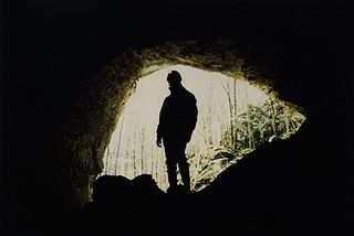
Speleology is the scientific study of caves and other karst features, as well as their composition, structure, physical properties, history, ecology, and the processes by which they form (speleogenesis) and change over time (speleomorphology). The term speleology is also sometimes applied to the recreational activity of exploring caves, but this is more properly known as caving, potholing, or spelunking. Speleology and caving are often connected, as the physical skills required for in situ study are the same.

The Swabian Jura, sometimes also named Swabian Alps in English, is a mountain range in Baden-Württemberg, Germany, extending 220 km (140 mi) from southwest to northeast and 40 to 70 km in width. It is named after the region of Swabia.

Stormwater, also written storm water, is water that originates from precipitation (storm), including heavy rain and meltwater from hail and snow. Stormwater can soak into the soil (infiltrate) and become groundwater, be stored on depressed land surface in ponds and puddles, evaporate back into the atmosphere, or contribute to surface runoff. Most runoff is conveyed directly as surface water to nearby streams, rivers or other large water bodies without treatment.

Travertine is a form of terrestrial limestone deposited around mineral springs, especially hot springs. It often has a fibrous or concentric appearance and exists in white, tan, cream-colored, and rusty varieties. It is formed by a process of rapid precipitation of calcium carbonate, often at the mouth of a hot spring or in a limestone cave. In the latter, it can form stalactites, stalagmites, and other speleothems. It is frequently used in Italy and elsewhere as a building material. Similar deposits formed from ambient-temperature water are known as tuff.

A springy is a natural exit point at which groundwater emerges out of the aquifer and flows onto the top of the Earth's crust (pedosphere) to become surface water. It is a component of the hydrosphere, as well as a part of the water cycle. Springs have long been important for humans as a source of fresh water, especially in arid regions which have relatively little annual rainfall.

A cenote is a natural pit, or sinkhole, resulting from the collapse of limestone bedrock that exposes groundwater. The term originated on the Yucatán Peninsula of Mexico, where cenotes were commonly used for water supplies by the ancient Maya, and occasionally for sacrificial offerings. The term derives from a word used by the lowland Yucatec Maya—tsʼonoʼot—to refer to any location with accessible groundwater.
Dye tracing is a method of tracking and tracing various flows using dye as a flow tracer when added to a liquid. Dye tracing may be used to analyse the flow of the liquid or the transport of objects within the liquid. Dye tracking may be either qualitative, showing the presence of a particular flow, or quantitative, when the amount of the traced dye is measured by special instruments.

Fontaine-de-Vaucluse is a commune in the southeastern French department of Vaucluse. In 2018, it had a population of 585. Its name comes from the spring of the same name; the name Vaucluse itself comes from the Latin phrase vallis clausa or "closed valley".
A rhythmic spring is a cold water spring from which the flow of water either varies or starts and stops entirely, over a fairly regular time-scale of minutes or hours. Compared to continuously-flowing springs, rhythmic springs are uncommon, with the number worldwide estimated in 1991 to be around one hundred.

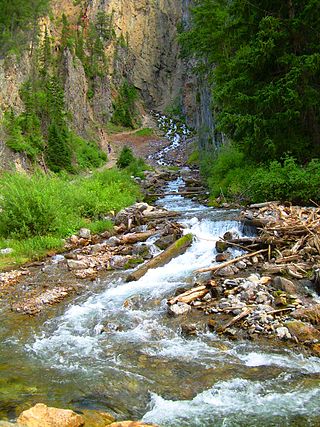
A stream is a continuous body of surface water flowing within the bed and banks of a channel. Depending on its location or certain characteristics, a stream may be referred to by a variety of local or regional names. Long, large streams are usually called rivers, while smaller, less voluminous and more intermittent streams are known as streamlets, brooks or creeks.
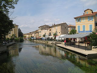
The Sorgue is a river in Southeastern France lying between the foothills of the Alps and the Rhône. It is 30.4 km long. Its source is near the town of Fontaine-de-Vaucluse, Vaucluse department. It is the biggest spring in France and the fifth biggest in the world.
The Nambung River is a river in the Wheatbelt region of Western Australia, 170 kilometres (106 mi) north of Perth. The river drains an area between the towns of Cervantes and Badgingarra. In its lower reaches the Nambung River forms a chain of waterholes in the Nambung Wetlands where it disappears underground into a limestone karst system 5.5 kilometres (3 mi) from the Indian Ocean.

A solutional cave, solution cave, or karst cave is a cave usually formed in the soluble rock limestone. It is the most frequently occurring type of cave. It can also form in other rocks, including chalk, dolomite, marble, salt beds, and gypsum.

The Bèze is a French river in the Côte-d'Or department, in the Bourgogne-Franche-Comté region. It is a right tributary of the Saône, and thus a sub-tributary of the Rhône.

The Fontaine de Vaucluse (French pronunciation:[fɔ̃tɛndəvoklyz]) is a karst spring in the commune of Fontaine-de-Vaucluse, France. It is the largest karst spring in metropolitan France by flow and fifth largest in the world, with annual output of 630,000,000 to 700,000,000 cubic metres (2.2×10¹⁰ to 2.5×10¹⁰ cu ft) of water. The spring is the prime example in hydrogeology of a "Vaucluse spring". It is the source of the Sorgue.

The Zalomka is a karstic river in the southern part of Bosnia and Herzegovina, and as part of the Neretva river system it is one of the largest sinking rivers in the country and Dinarides. It rises under the Morine plateau, near Brajićevići village in Gacko municipality, but also collects its upper course waters from Gatačko Polje.
An anchialine system is a landlocked body of water with a subterranean connection to the ocean. Depending on its formation, these systems can exist in one of two primary forms: pools or caves. The primary differentiating characteristics between pools and caves is the availability of light; cave systems are generally aphotic while pools are euphotic. The difference in light availability has a large influence on the biology of a given system. Anchialine systems are a feature of coastal aquifers which are density stratified, with water near the surface being fresh or brackish, and saline water intruding from the coast at depth. Depending on the site, it is sometimes possible to access the deeper saline water directly in the anchialine pool, or sometimes it may be accessible by cave diving.
 Fontaine-de-Vaucluse, karst spring of the Sorgue, characterised by an upward movement of water from the depth of over 315 metres (1,033 ft)
 A submarine karst spring (vrulja), observed through sea surface rippling near Omiš
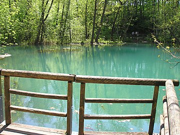 Rhumequelle (Rhume Spring), source of the Rhume, in Herzberg am Harz-Rhumasprung (de) right next to Rhumspringe
 Maramec Spring in the Ozarks, Missouri
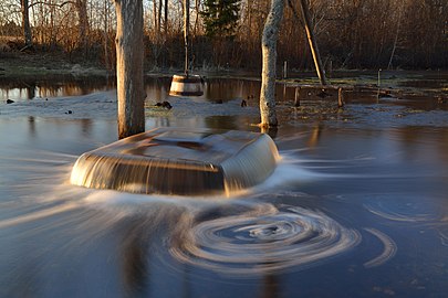
 The Mshentsy spring, Bologovsky district, Tver region, Russia


