Related Research Articles

A floodplain or flood plain or bottomlands is an area of land adjacent to a river which stretches from the banks of its channel to the base of the enclosing valley walls, and which experiences flooding during periods of high discharge. The soils usually consist of clays, silts, sands, and gravels deposited during floods.

A braided river, or braided channel, consists of a network of river channels separated by small, often temporary, islands called braid bars or, in English usage, aits or eyots.

In geography and geology, fluvial processes are associated with rivers and streams and the deposits and landforms created by them. When the stream or rivers are associated with glaciers, ice sheets, or ice caps, the term glaciofluvial or fluvioglacial is used.
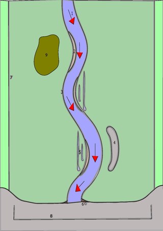
An oxbow lake is a U-shaped lake or pool that forms when a wide meander of a river is cut off, creating a free-standing body of water. In South Texas, oxbows left by the Rio Grande are called resacas. In Australia, oxbow lakes are called billabongs. The word "oxbow" can also refer to a U-shaped bend in a river or stream, whether or not it is cut off from the main stream.

The Kobuk River is a river located in the Arctic region of northwestern Alaska in the United States. It is approximately 280 miles (451 km) long. Draining a basin with an area of 12,300 square miles (32,000 km2), the Kobuk River is among the largest rivers in northwest Alaska with widths of up to 1,500 feet and flow at a speed of 3–5 miles per hour in its lower and middle reaches. The average elevation for the Kobuk River Basin is 1,300 feet (400 m) above sea level, ranging from near sea level to 11,400 feet. Topography includes low, rolling mountains, plains and lowlands, moderately high rugged mountainous land, and some gently sloped plateaus and highlands. The river contains an exceptional population of sheefish, a large predatory whitefish within the salmon family, found throughout the Arctic that spawns in the river's upper reaches during the autumn. A portion of the vast Western Arctic Caribou Herd utilize the Kobuk river valley as winter range.

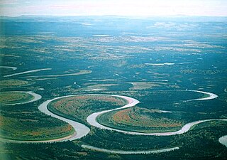
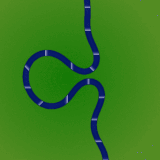
A meander is one of a series of regular sinuous curves in the channel of a river or other watercourse. It is produced as a watercourse erodes the sediments of an outer, concave bank and deposits sediments on an inner, convex bank which is typically a point bar. The result of this coupled erosion and sedimentation is the formation of a sinuous course as the channel migrates back and forth across the axis of a floodplain.

Upland and lowland are conditional descriptions of a plain based on elevation above sea level. In studies of the ecology of freshwater rivers, habitats are classified as upland or lowland.
The terms river morphology and its synonym stream morphology are used to describe the shapes of river channels and how they change in shape and direction over time. The morphology of a river channel is a function of a number of processes and environmental conditions, including the composition and erodibility of the bed and banks ; erosion comes from the power and consistency of the current, and can effect the formation of the river's path. Also, vegetation and the rate of plant growth; the availability of sediment; the size and composition of the sediment moving through the channel; the rate of sediment transport through the channel and the rate of deposition on the floodplain, banks, bars, and bed; and regional aggradation or degradation due to subsidence or uplift. River morphology can also be affected by human interaction, which is a way the river responds to a new factor in how the river can change its course. An example of human induced change in river morphology is dam construction, which alters the ebb flow of fluvial water and sediment, therefore creating or shrinking estuarine channels. A river regime is a dynamic equilibrium system, which is a way of classifying rivers into different categories. The four categories of river regimes are Sinuous canali- form rivers, Sinuous point bar rivers, Sinuous braided rivers, and Non-sinuous braided rivers.

River bifurcation occurs when a river flowing in a single stream separates into two or more separate streams which then continue downstream. Some rivers form complex networks of distributaries, typically in their deltas. If the streams eventually merge again or empty into the same body of water, then the bifurcation forms a river island.

A crevasse splay is a sedimentary fluvial deposit which forms when a stream breaks its natural or artificial levees and deposits sediment on a floodplain. A breach that forms a crevasse splay deposits sediments in similar pattern to an alluvial fan deposit. Once the levee has been breached the water flows out of its channel. As the water spreads onto the flood plain sediments will start to fall out of suspension as the water loses energy. The resulting deposition can create graded deposits similar to those found in Bouma sequences. In some cases crevasse splays can cause a river to abandon its old river channel, a process known as avulsion. Breaches that form a crevasse splay deposits occur most commonly on the outside banks of meanders where the water has the highest energy. Crevasse splay deposits can range in size. Larger deposits can be 6 m (20 ft) thick at the levee and spread 2 km (1.2 mi) wide, while smaller deposits may only be 1 cm (0.39 in) thick.
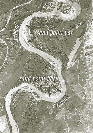
A point bar is a depositional feature made of alluvium that accumulates on the inside bend of streams and rivers below the slip-off slope. Point bars are found in abundance in mature or meandering streams. They are crescent-shaped and located on the inside of a stream bend, being very similar to, though often smaller than, towheads, or river islands.
In fluid dynamics, flow can be decomposed into primary plus secondary flow, a relatively weaker flow pattern superimposed on the stronger primary flow pattern. The primary flow is often chosen to be an exact solution to simplified or approximated governing equations, such as potential flow around a wing or geostrophic current or wind on the rotating Earth. In that case, the secondary flow usefully spotlights the effects of complicated real-world terms neglected in those approximated equations. For instance, the consequences of viscosity are spotlighted by secondary flow in the viscous boundary layer, resolving the tea leaf paradox. As another example, if the primary flow is taken to be a balanced flow approximation with net force equated to zero, then the secondary circulation helps spotlight acceleration due to the mild imbalance of forces. A smallness assumption about secondary flow also facilitates linearization.

A river is a natural flowing watercourse, usually freshwater, flowing towards an ocean, sea, lake or another river. In some cases, a river flows into the ground and becomes dry at the end of its course without reaching another body of water. Small rivers can be referred to using names such as creek, brook, rivulet, and rill. There are no official definitions for the generic term river as applied to geographic features, although in some countries or communities a stream is defined by its size. Many names for small rivers are specific to geographic location; examples are "run" in some parts of the United States, "burn" in Scotland and northeast England, and "beck" in northern England. Sometimes a river is defined as being larger than a creek, but not always: the language is vague.
In geology, a backswamp is a type of depositional environment commonly found in a floodplain. It is where deposits of fine silts and clays settle after a flood. These deposits create a marsh-like landscape that is often poorly drained and usually lower than the rest of the floodplain.

In sedimentary geology and fluvial geomorphology, avulsion is the rapid abandonment of a river channel and the formation of a new river channel. Avulsions occur as a result of channel slopes that are much less steep than the slope that the river could travel if it took a new course.

A bar in a river is an elevated region of sediment that has been deposited by the flow. Types of bars include mid-channel bars, point bars, and mouth bars. The locations of bars are determined by the geometry of the river and the flow through it. Bars reflect sediment supply conditions, and can show where sediment supply rate is greater than the transport capacity.
River channel migration is the geomorphological process that involves the lateral migration of an alluvial river channel across its floodplain. This process is mainly driven by the combination of bank erosion of and point bar deposition over time. When referring to river channel migration, it is typically in reference to meandering streams. In braided streams, channel change is driven by sediment transport.

An alluvial river is one in which the bed and banks are made up of mobile sediment and/or soil. Alluvial rivers are self-formed, meaning that their channels are shaped by the magnitude and frequency of the floods that they experience, and the ability of these floods to erode, deposit, and transport sediment. For this reason, alluvial rivers can assume a number of forms based on the properties of their banks; the flows they experience; the local riparian ecology; and the amount, size, and type of sediment that they carry.
A meander cutoff is a natural form of a cutting or cut in a river occurs when a pronounced meander (hook) in a river is breached by a flow that connects the two closest parts of the hook to form a new channel, a full loop. The steeper drop in gradient (slope) causes the river flow gradually to abandon the meander which will silt up with sediment from deposition. Cutoffs are a natural part of the evolution of a meandering river. Rivers form meanders as they flow laterally downstream, see sinuosity.

A slip-off slope is a depositional landform that occurs on the inside convex bank of a meandering river. The term can refer to two different features: one in a freely meandering river with a floodplain and the other in an entrenched river.
References
- ↑ Hickin, Edward J. (2003), "Meandering Channels", in Middleton, Gerard V. (ed.), Encyclopedia of Sediments and Sedimentary Rocks, New York: Springer, p. 432 ISBN 1-4020-0872-4