Related Research Articles

The horizon is the apparent curve that separates the surface of a celestial body from its sky when viewed from the perspective of an observer on or near the surface of the relevant body. This curve divides all viewing directions based on whether it intersects the relevant body's surface or not.

A mirage is a naturally-occurring optical phenomenon in which light rays bend via refraction to produce a displaced image of distant objects or the sky. The word comes to English via the French (se) mirer, from the Latin mirari, meaning "to look at, to wonder at".

High frequency (HF) is the ITU designation for the band of radio waves with frequency between 3 and 30 megahertz (MHz). It is also known as the decameter band or decameter wave as its wavelengths range from one to ten decameters. Frequencies immediately below HF are denoted medium frequency (MF), while the next band of higher frequencies is known as the very high frequency (VHF) band. The HF band is a major part of the shortwave band of frequencies, so communication at these frequencies is often called shortwave radio. Because radio waves in this band can be reflected back to Earth by the ionosphere layer in the atmosphere – a method known as "skip" or "skywave" propagation – these frequencies can be used for long-distance communication across intercontinental distances and for mountainous terrains which prevent line-of-sight communications. The band is used by international shortwave broadcasting stations (3.95–25.82 MHz), aviation communication, government time stations, weather stations, amateur radio and citizens band services, among other uses.
Radio propagation is the behavior of radio waves as they travel, or are propagated, from one point to another in vacuum, or into various parts of the atmosphere. As a form of electromagnetic radiation, like light waves, radio waves are affected by the phenomena of reflection, refraction, diffraction, absorption, polarization, and scattering. Understanding the effects of varying conditions on radio propagation has many practical applications, from choosing frequencies for amateur radio communications, international shortwave broadcasters, to designing reliable mobile telephone systems, to radio navigation, to operation of radar systems.

A spring is a natural exit point at which groundwater emerges from the aquifer and flows onto the top of the Earth's crust (pedosphere) to become surface water. It is a component of the hydrosphere, as well as a part of the water cycle. Springs have long been important for humans as a source of fresh water, especially in arid regions which have relatively little annual rainfall.

In usage in the Southern United States, a bayou is a body of water typically found in a flat, low-lying area. It may refer to an extremely slow-moving stream, river, marshy lake, wetland, or creek. They typically contain brackish water highly conducive to fish life and plankton. Bayous are commonly found in the Gulf Coast region of the southern United States, especially in the Mississippi River Delta, though they also exist elsewhere.
In soil science, podzols, also known as podosols, spodosols, or espodossolos, are the typical soils of coniferous or boreal forests and also the typical soils of eucalypt forests and heathlands in southern Australia. In Western Europe, podzols develop on heathland, which is often a construct of human interference through grazing and burning. In some British moorlands with podzolic soils, cambisols are preserved under Bronze Age barrows.
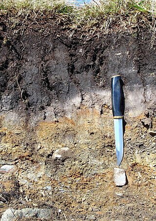
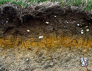
A soil horizon is a layer parallel to the soil surface whose physical, chemical and biological characteristics differ from the layers above and beneath. Horizons are defined in many cases by obvious physical features, mainly colour and texture. These may be described both in absolute terms and in terms relative to the surrounding material, i.e. 'coarser' or 'sandier' than the horizons above and below.

Impervious surfaces are mainly artificial structures—such as pavements that are covered by water-resistant materials such as asphalt, concrete, brick, stone—and rooftops. Soils compacted by urban development are also highly impervious.
Podsolisation is an extreme form of leaching which causes the eluviation of iron and aluminium sesquioxides.

The membranous layer of the superficial fascia of the perineum is the deeper layer of the superficial perineal fascia. It is thin, aponeurotic in structure, and of considerable strength, serving to bind down the muscles of the root of the penis. Colles' fascia emerges from the perineal membrane, which divides the base of the penis from the prostate. Colles' fascia emerges from the inferior side of the perineal membrane and continues along the ventral (inferior) penis without covering the scrotum. It separates the skin and subcutaneous fat from the superficial perineal pouch.
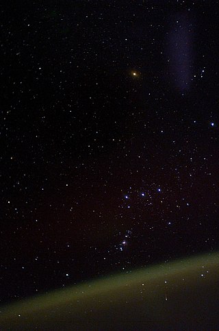
Sky brightness refers to the visual perception of the sky and how it scatters and diffuses light. The fact that the sky is not completely dark at night is easily visible. If light sources were removed from the night sky, only direct starlight would be visible.
The soil biomantle can be described and defined in several ways. Most simply, the soil biomantle is the organic-rich bioturbated upper part of the soil, including the topsoil where most biota live, reproduce, die, and become assimilated. The biomantle is thus the upper zone of soil that is predominantly a product of organic activity and the area where bioturbation is a dominant process.
The bar of a mature tropical cyclone is a very dark gray-black layer of cloud that appears to be near to the horizon as seen from an observer preceding the approach of the storm, and is composed primarily of dense stratocumulus clouds. Cumulus and cumulonimbus clouds bearing precipitation follow immediately after the passage of the wall-like bar. Altostratus, cirrostratus and cirrus clouds are usually visible in ascending order above the top of the bar, while the wind direction for an observer facing toward the bar is typically from the left and slightly behind the observer.
The Oro Moraine is a glacial moraine in Simcoe County, Ontario, Canada. The moraine covers 141 square kilometres (54 sq mi) north of Barrie, Ontario. The moraine drains into Georgian Bay on Lake Huron, and the smaller Lake Simcoe.
Pit water, mine water or mining water is water that collects in a mine and which has to be brought to the surface by water management methods in order to enable the mine to continue working.
In geology, a horizon is either a bedding surface where there is marked change in the lithology within a sequence of sedimentary or volcanic rocks, or a distinctive layer or thin bed with a characteristic lithology or fossil content within a sequence. Examples of the former can include things such as volcanic eruptions as well as things such as meteorite impacts and tsunamis. Examples of the latter include things such as ice ages and other large climate events, as well as large but temporary geological features and changes such as inland oceans. In the interpretation of seismic reflection data, horizons are the reflectors picked on individual profiles. These reflectors represent a change in rock properties across a boundary between two layers of rock, particularly seismic velocity and density. It can also represent changes in the density of the material and the composition of it and the pressure under which it was produced. Thus, not only do the properties change but so too do the conditions of formation and other differences in the rock. The horizons can sometimes be very prominent, such as visible changes in cliff sides, to extremely subtle chemical differences.
A stagnogley soil is a type of non-alluvial, non-calcareous soil that is typically loamy or clayey soil with a dense, impervious, subsurface horizon. Stagnogley soils are related to the pseudogleys and are classified as gleyic soils. The name "stagnogley" comes from the soil's gley dynamics. This hygroscopic soil is nutrient-poor, often highly acidic, and poorly aerated, making it unsuitable for farming due to poor crop growth. With a shallow topsoil layer and a moderately stony subsoil, stagnogley soil is mainly used for woodland, supporting tree species that thrive well in these conditions, such as the English Oak.
Qadad or qudad is a waterproof plaster surface, made of a lime plaster treated with slaked lime and oils and fats. The technique is over a thousand years old, with the remains of this early plaster still seen on the standing sluices of the ancient Marib Dam.

Sheet vinyl flooring is vinyl flooring that comes in large, continuous, flexible sheets. A vinyl sheet floor is completely impermeable to water, unlike vinyl floor tile, which comes in stiff tiles, and vinyl planks, which come in interlocking strips. It is sometimes called linoleum after a visually similar product of different chemical composition.
References
- ↑ Leser, Hartmut et al. Wörterbuch Allgemeine Geographie, dtv, 14th ed., Mar 2010. ISBN 978-3-423-03422-7.
| | This geology article is a stub. You can help Wikipedia by expanding it. |
| | This hydrology article is a stub. You can help Wikipedia by expanding it. |