Related Research Articles

Hydrology is the scientific study of the movement, distribution, and management of water on Earth and other planets, including the water cycle, water resources, and drainage basin sustainability. A practitioner of hydrology is called a hydrologist. Hydrologists are scientists studying earth or environmental science, civil or environmental engineering, and physical geography. Using various analytical methods and scientific techniques, they collect and analyze data to help solve water related problems such as environmental preservation, natural disasters, and water management.

An aquifer is an underground layer of water-bearing material, consisting of permeable or fractured rock, or of unconsolidated materials. Aquifers vary greatly in their characteristics. The study of water flow in aquifers and the characterization of aquifers is called hydrogeology. Related terms include aquitard, which is a bed of low permeability along an aquifer, and aquiclude, which is a solid, impermeable area underlying or overlying an aquifer, the pressure of which could lead to the formation of a confined aquifer. The classification of aquifers is as follows: Saturated versus unsaturated; aquifers versus aquitards; confined versus unconfined; isotropic versus anisotropic; porous, karst, or fractured; transboundary aquifer.
Surface-water hydrology is the sub-field of hydrology concerned with above-earth water, in contrast to groundwater hydrology that deals with water below the surface of the Earth. Its applications include rainfall and runoff, the routes that surface water takes, and the occurrence of floods and droughts. Surface-water hydrology is used to predict the effects of water constructions such as dams and canals. It considers the layout of the watershed, geology, soils, vegetation, nutrients, energy and wildlife. Modelled aspects include precipitation, the interception of rain water by vegetation or artificial structures, evaporation, the runoff function and the soil-surface system itself.

A hydrograph is a graph showing the rate of flow (discharge) versus time past a specific point in a river, channel, or conduit carrying flow. The rate of flow is typically expressed in cubic meters or cubic feet per second . Hydrographs often relate changes of precipitation to changes in discharge over time. It can also refer to a graph showing the volume of water reaching a particular outfall, or location in a sewerage network. Graphs are commonly used in the design of sewerage, more specifically, the design of surface water sewerage systems and combined sewers.
In hydrology, discharge is the volumetric flow rate of a stream. It equals the product of average flow velocity and the cross-sectional area. It includes any suspended solids, dissolved chemicals, or biologic material in addition to the water itself. Terms may vary between disciplines. For example, a fluvial hydrologist studying natural river systems may define discharge as streamflow, whereas an engineer operating a reservoir system may equate it with outflow, contrasted with inflow.
In hydrology, there are two similar but distinct definitions in use for the word drawdown:
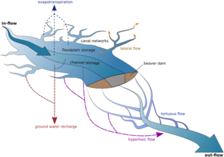
Ecohydrology is an interdisciplinary scientific field studying the interactions between water and ecological systems. It is considered a sub discipline of hydrology, with an ecological focus. These interactions may take place within water bodies, such as rivers and lakes, or on land, in forests, deserts, and other terrestrial ecosystems. Areas of research in ecohydrology include transpiration and plant water use, adaption of organisms to their water environment, influence of vegetation and benthic plants on stream flow and function, and feedbacks between ecological processes, the soil carbon sponge and the hydrological cycle.
Isotope hydrology is a field of geochemistry and hydrology that uses naturally occurring stable and radioactive isotopic techniques to evaluate the age and origins of surface and groundwater and the processes within the atmospheric hydrologic cycle. Isotope hydrology applications are highly diverse, and used for informing water-use policy, mapping aquifers, conserving water supplies, assessing sources of water pollution, and increasingly are used in eco-hydrology to study human impacts on all dimensions of the hydrological cycle and ecosystem services.
Drainage density is a quantity used to describe physical parameters of a drainage basin. First described by Robert E. Horton, drainage density is defined as the total length of channel in a drainage basin divided by the total area, represented by the following equation:

Infiltration is the process by which water on the ground surface enters the soil. It is commonly used in both hydrology and soil sciences. The infiltration capacity is defined as the maximum rate of infiltration. It is most often measured in meters per day but can also be measured in other units of distance over time if necessary. The infiltration capacity decreases as the soil moisture content of soils surface layers increases. If the precipitation rate exceeds the infiltration rate, runoff will usually occur unless there is some physical barrier.
The United States Environmental Protection Agency (EPA) Storm Water Management Model (SWMM) is a dynamic rainfall–runoff–subsurface runoff simulation model used for single-event to long-term (continuous) simulation of the surface/subsurface hydrology quantity and quality from primarily urban/suburban areas.
Runoff is the flow of water across the earth, and is a major component in the hydrological cycle. Runoff that flows over land before reaching a watercourse is referred to as surface runoff or overland flow. Once in a watercourse, runoff is referred to as streamflow, channel runoff, or river runoff. Urban runoff is surface runoff created by urbanization.
Streamflow, or channel runoff, is the flow of water in streams and other channels, and is a major element of the water cycle. It is one runoff component, the movement of water from the land to waterbodies, the other component being surface runoff. Water flowing in channels comes from surface runoff from adjacent hillslopes, from groundwater flow out of the ground, and from water discharged from pipes. The discharge of water flowing in a channel is measured using stream gauges or can be estimated by the Manning equation. The record of flow over time is called a hydrograph. Flooding occurs when the volume of water exceeds the capacity of the channel.

An hydrological transport model is a mathematical model used to simulate the flow of rivers, streams, groundwater movement or drainage front displacement, and calculate water quality parameters. These models generally came into use in the 1960s and 1970s when demand for numerical forecasting of water quality and drainage was driven by environmental legislation, and at a similar time widespread access to significant computer power became available. Much of the original model development took place in the United States and United Kingdom, but today these models are refined and used worldwide.

Groundwater recharge or deep drainage or deep percolation is a hydrologic process, where water moves downward from surface water to groundwater. Recharge is the primary method through which water enters an aquifer. This process usually occurs in the vadose zone below plant roots and is often expressed as a flux to the water table surface. Groundwater recharge also encompasses water moving away from the water table farther into the saturated zone. Recharge occurs both naturally and through anthropogenic processes, where rainwater and or reclaimed water is routed to the subsurface.
In hydrogeology, groundwater flow is defined as the "part of streamflow that has infiltrated the ground, entered the phreatic zone, and has been discharged into a stream channel or springs; and seepage water." It is governed by the groundwater flow equation. Groundwater is water that is found underground in cracks and spaces in the soil, sand and rocks. Where water has filled these spaces is the phreatic saturated zone. Groundwater is stored in and moves slowly through layers or zones of soil, sand and rocks: aquifers. The rate of groundwater flow depends on the permeability and the hydraulic head.

A runoff models or rainfall-runoff model describes how rainfall is converted into runoff in a drainage basin. More precisely, it produces a surface runoff hydrograph in response to a rainfall event, represented by and input as a hyetograph. Rainfall-runoff models need to be calibrated before they can be used.
GSSHA is a two-dimensional, physically based watershed model developed by the Engineer Research and Development Center of the United States Army Corps of Engineers. It simulates surface water and groundwater hydrology, erosion and sediment transport. The GSSHA model is used for hydraulic engineering and research, and is on the Federal Emergency Management Agency (FEMA) list of hydrologic models accepted for use in the national flood insurance program for flood hydrograph estimation. Input is best prepared by the Watershed Modeling System interface, which effectively links the model with geographic information systems (GIS).
Baseflow residence time is a parameter useful in describing the mixing of waters from the infiltration of precipitation and pre-event groundwater in a watershed. It describes the average amount of time that water within the transient water supply resides in a watershed. Many methods of determining baseflow residence time have been developed, mostly involving mathematical models using a convolution integral approach with isotopic or chemical data as the input. Other methods that do not require such extensive and expensive data collection include Brutsaert and Nieber, which uses aquifer parameters as inputs, and Vitvar et al., which uses the stream flow hydrograph to determine baseflow recession parameters.

Catchment hydrology is the study of hydrology in drainage basins. Catchments are areas of land where runoff collects to a specific zone. This movement is caused by water moving from areas of high energy to low energy due to the influence of gravity. Catchments often do not last for long periods of time as the water evaporates, drains into the soil, or is consumed by animals.
References
- ↑ Kendall and McDonnell (1998). "Isotope Tracers in Catchment Hydrology". Elsevier. Archived from the original on July 5, 2008. Retrieved July 10, 2009.
{{cite journal}}: Cite journal requires|journal=(help) - ↑ Ward, Andy and Trimble, Stanley (2003). Environmental Hydrology, Second Edition. CRC Press. ISBN 978-1-4200-5661-7.
{{cite book}}: CS1 maint: multiple names: authors list (link) - ↑ R., Bierman, Paul (2013-12-27). Key concepts in geomorphology. Montgomery, David R., 1961-, University of Vermont., University of Washington. New York, NY. ISBN 9781429238601. OCLC 868029499.
{{cite book}}: CS1 maint: location missing publisher (link) CS1 maint: multiple names: authors list (link) - 1 2 Mount, Jeffrey F. (1995). California rivers and streams : the conflict between fluvial process and land use. Berkeley: University of California Press. ISBN 9780520916937. OCLC 42330977.
- ↑ Glynn, Pierre D.; Plummer, L. Niel (2005-03-01). "Geochemistry and the understanding of ground-water systems". Hydrogeology Journal. 13 (1): 263–287. Bibcode:2005HydJ...13..263G. doi:10.1007/s10040-004-0429-y. ISSN 1431-2174. S2CID 129716764.
- ↑ O'Keeffe, Jay (2009). "Sustaining river ecosystems: balancing use and protection". Progress in Physical Geography: Earth and Environment. 33 (3): 339–357. doi:10.1177/0309133309342645. S2CID 131587514.
- ↑ Stedinger, JR, Vogel, RM, and Foufoula-Georgiou, E (1993). Handbook of Hydrology. McGraw-Hill.
{{cite book}}: CS1 maint: multiple names: authors list (link) - ↑ Bloomfield, J.P.; Allen, D.J.; Griffiths, K.J. (2009-06-30). "Examining geological controls on baseflow index (BFI) using regression analysis: An illustration from the Thames Basin, UK" (PDF). Journal of Hydrology. 373 (1–2): 164–176. Bibcode:2009JHyd..373..164B. doi:10.1016/j.jhydrol.2009.04.025. ISSN 0022-1694.
- ↑ Posavec, Kristijan; Bacani, Andrea; Nakic, Zoran (2006-05-26). "A Visual Basic Spreadsheet Macro for Recession Curve Analysis". Ground Water. 44 (5): 060526082055001––. doi:10.1111/j.1745-6584.2006.00226.x. ISSN 0017-467X. PMID 16961500. S2CID 12485813.
- ↑ Vitvar; et al. (2002). "Estimation of baseflow residence times in watersheds from the runoff hydrograph recession: method and application in the Neversink watershed, Catskill Mountains, New York" (PDF). Hydrol. Processes. 16 (9): 1871–1877. Bibcode:2002HyPr...16.1871V. doi:10.1002/hyp.5027. S2CID 28833693. Archived from the original (PDF) on 2016-03-03. Retrieved 2009-07-10.
- 1 2 Price, Katie (2011). "Effects of watershed topography, soils, land use, and climate on baseflow hydrology in humid regions: A review". Progress in Physical Geography. 35 (4): 465–492. doi:10.1177/0309133311402714. S2CID 7544941.
- ↑ "HydroOffice | Tool | BFI+". hydrooffice.org. Retrieved 2023-05-19.
| Authority control databases: National |
|---|