Plunge pool

Last updated
Surface of the Seljalandsfoss plunge pool (Iceland) Seljalandsfoss plungepool.jpg
Surface of the Seljalandsfoss plunge pool (Iceland)
Water going over the falls carries sand and pebbles that scour a plunge pool at its base. Plunge pool.png
Water going over the falls carries sand and pebbles that scour a plunge pool at its base.

A plunge pool (or plunge basin or waterfall lake) is a deep depression in a stream bed at the base of a waterfall or shut-in. It is created by the erosional forces of cascading water on the rocks at the formation's base where the water impacts. [1] The term may refer to the water occupying the depression, or the depression itself. [2]

Contents

Formation

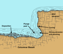
Plunge pools are formed by the natural force of falling water, such as at a waterfall or cascade; they also result from man-made structures such as some spillway designs. [3] Plunge pools are often very deep, generally related to the height of the fall, the volume of water, the resistance of the rock below the pool and other factors. [4] The impacting and swirling water, sometimes carrying rocks within it, abrades the riverbed into a basin, which often features rough and irregular sides. Plunge pools can remain long after the waterfall has ceased flow or the stream has been diverted. Several examples of former plunge pools exist at Dry Falls in the Channeled Scablands of eastern Washington. [5] They can also be found underwater in areas that were formerly above sea level, for example, Perth Canyon off the coast of Western Australia.

Plunge pools are fluvial features of erosion which occur in the youthful stage of river development, characterized by steeper gradients and faster water flows. Where softer or fractured rock has been eroded back to a knickpoint, water continues to bombard its base. Because this rock is often less resistant than overlying strata, the water from the higher elevation continues eroding downward until an equilibrium is achieved.

A somewhat similar bowl-shaped feature developed by flowing water, as opposed to falling water, is known as a scour hole. These occur both naturally and as a result of bridge building.

See also

Related Research Articles

<span class="mw-page-title-main">Erosion</span> Natural processes removing soil and rock

Erosion is the action of surface processes that removes soil, rock, or dissolved material from one location on the Earth's crust and then transports it to another location where it is deposited. Erosion is distinct from weathering which involves no movement. Removal of rock or soil as clastic sediment is referred to as physical or mechanical erosion; this contrasts with chemical erosion, where soil or rock material is removed from an area by dissolution. Eroded sediment or solutes may be transported just a few millimetres, or for thousands of kilometres.

<span class="mw-page-title-main">Valley</span> Low area between hills, often with a river running through it

A valley is an elongated low area often running between hills or mountains and typically containing a river or stream running from one end to the other. Most valleys are formed by erosion of the land surface by rivers or streams over a very long period. Some valleys are formed through erosion by glacial ice. These glaciers may remain present in valleys in high mountains or polar areas.

<span class="mw-page-title-main">Sediment</span> Particulate solid matter deposited on a planetary surface

Sediment is a solid material that is transported to a new location where it is deposited. It occurs naturally and, through the processes of weathering and erosion, is broken down and subsequently transported by the action of wind, water, or ice or by the force of gravity acting on the particles. For example, sand and silt can be carried in suspension in river water and on reaching the sea bed deposited by sedimentation; if buried, they may eventually become sandstone and siltstone through lithification.

<span class="mw-page-title-main">Waterfall</span> A point in a river or stream where water flows over a vertical drop

A waterfall is any point in a river or stream where water flows over a vertical drop or a series of steep drops. Waterfalls also occur where meltwater drops over the edge of a tabular iceberg or ice shelf.

<span class="mw-page-title-main">Entrenched river</span>

An entrenched river, or entrenched stream is a river or stream that flows in a narrow trench or valley cut into a plain or relatively level upland. Because of lateral erosion streams flowing over gentle slopes over a time develops meandering course. Meanders form where gradient is very gentle, for example in floodplain and delta. Meandering is the feature of the middle and final course of the river. But very deep and wide meanders can also be found cutting hard rocks. Such meanders are called incised or entrenched meanders. The exception is that entrenched meanders are formed during the upliftment of land where river is young. They widen and deepen over time and can be found as deep gorges or canyons in hard rock. In the case of an entrenched stream or river, it is often presumed that the watercourse has inherited its course by cutting down into bedrock from a pre-existing plain with little modification of the original course. The down-cutting of the river system could be the result not only of tectonic uplift but also of other factors such as river piracy, decrease of load, increase of runoff, extension of the drainage basin, or change in base level such as a fall in sea level. General, nongeneric terminology for either a river or stream that flows in a narrow trench or valley, for which evidence of a preexisting plain or relatively level upland can be either absent or present is either valley meander or meander valley with the latter term being preferred in literature.

<span class="mw-page-title-main">Fluvial sediment processes</span> Sediment processes associated with rivers and streams

In geography and geology, fluvial sediment processes or fluvial sediment transport are associated with rivers and streams and the deposits and landforms created by sediments. It can result in the formation of ripples and dunes, in fractal-shaped patterns of erosion, in complex patterns of natural river systems, and in the development of floodplains and the occurrence of flash floods. Sediment moved by water can be larger than sediment moved by air because water has both a higher density and viscosity. In typical rivers the largest carried sediment is of sand and gravel size, but larger floods can carry cobbles and even boulders. When the stream or rivers are associated with glaciers, ice sheets, or ice caps, the term glaciofluvial or fluvioglacial is used, as in periglacial flows and glacial lake outburst floods. Fluvial sediment processes include the motion of sediment and erosion or deposition on the river bed.

Landforms are categorized by characteristic physical attributes such as their creating process, shape, elevation, slope, orientation, rock exposure, and soil type.

<span class="mw-page-title-main">Missoula floods</span> Heavy floods of the last ice age

The Missoula floods were cataclysmic glacial lake outburst floods that swept periodically across eastern Washington and down the Columbia River Gorge at the end of the last ice age. These floods were the result of periodic sudden ruptures of the ice dam on the Clark Fork River that created Glacial Lake Missoula. After each ice dam rupture, the waters of the lake would rush down the Clark Fork and the Columbia River, flooding much of eastern Washington and the Willamette Valley in western Oregon. After the lake drained, the ice would reform, creating Glacial Lake Missoula again.

<span class="mw-page-title-main">Grand Coulee</span> Ancient river bed in the U.S. state of Washington

Grand Coulee is an ancient river bed in the U.S. state of Washington. This National Natural Landmark stretches for about 60 miles (100 km) southwest from Grand Coulee Dam to Soap Lake, being bisected by Dry Falls into the Upper and Lower Grand Coulee.

<span class="mw-page-title-main">Channeled Scablands</span> Landscape in eastern Washington state scoured by cataclysmic floods during the Pleistocene epoch

The Channeled Scablands are a relatively barren and soil-free region of interconnected relict and dry flood channels, coulees and cataracts eroded into Palouse loess and the typically flat-lying basalt flows that remain after cataclysmic floods within the southeastern part of Washington state. The Channeled Scablands were scoured by more than 40 cataclysmic floods during the Last Glacial Maximum and innumerable older cataclysmic floods over the last two million years. These floods were periodically unleashed whenever a large glacial lake broke through its ice dam and swept across eastern Washington and down the Columbia River Plateau during the Pleistocene epoch. The last of the cataclysmic floods occurred between 18,200 and 14,000 years ago.

<span class="mw-page-title-main">Glacial landform</span> Landform created by the action of glaciers

Glacial landforms are landforms created by the action of glaciers. Most of today's glacial landforms were created by the movement of large ice sheets during the Quaternary glaciations. Some areas, like Fennoscandia and the southern Andes, have extensive occurrences of glacial landforms; other areas, such as the Sahara, display rare and very old fossil glacial landforms.

<span class="mw-page-title-main">Hydraulic action</span> Force of water and tapped air pockets against a rock surface

Hydraulic action, most generally, is the ability of moving water to dislodge and transport rock particles. This includes a number of specific erosional processes, including abrasion, at facilitated erosion, such as static erosion where water leaches salts and floats off organic material from unconsolidated sediments, and from chemical erosion more often called chemical weathering. It is a mechanical process, in which the moving water current flows against the banks and bed of a river, thereby removing rock particles. A primary example of hydraulic action is a wave striking a cliff face which compresses the air in cracks of the rocks. This exerts pressure on the surrounding rock which can progressively crack, break, splinter and detach rock particles. This is followed by the decompression of the air as the wave retreats which can occur suddenly with explosive force which additionally weakens the rock. Cracks are gradually widened so each wave compresses more air, increasing the explosive force of its release. Thus, the effect intensifies in a 'positive feedback' system. Over time, as the cracks may grow they sometimes form a sea cave. The broken pieces that fall off produce two additional types of erosion, abrasion (sandpapering) and attrition. In corrasion, the newly formed chunks are thrown against the rock face. Attrition is a similar effect caused by eroded particles after they fall to the sea bed where they are subjected to further wave action. In coastal areas wave hydraulic action is often the most important form of erosion.

<span class="mw-page-title-main">Knickpoint</span> Point on a streams profile where a sudden change in stream gradient occurs

In geomorphology, a knickpoint or nickpoint is part of a river or channel where there is a sharp change in channel bed slope, such as a waterfall or lake. Knickpoints reflect different conditions and processes on the river, often caused by previous erosion due to glaciation or variance in lithology. In the cycle of erosion model, knickpoints advance one cycle upstream, or inland, replacing an older cycle. A knickpoint that occurs at the head of a channel is called a headcut. Headcuts resulting in headward erosion are hallmarks of unstable expanding drainage features such as actively eroding gullies.

<span class="mw-page-title-main">Headward erosion</span> The Geographical processes of the Earth

Headward erosion is erosion at the origin of a stream channel, which causes the origin to move back away from the direction of the stream flow, lengthening the stream channel. It can also refer to the widening of a canyon by erosion along its very top edge, when sheets of water first enter the canyon from a more roughly planar surface above it, such as at Canyonlands National Park in Utah. When sheets of water on a roughly planar surface first enter a depression in it, this erodes the top edge of the depression. The stream is forced to grow longer at the very top of the stream, which moves its origin back, or causes the canyon formed by the stream to grow wider as the process repeats. Widening of the canyon by erosion inside the canyon, below the canyon side top edge, or origin or the stream, such as erosion caused by the streamflow inside it, is not called headward erosion.

<span class="mw-page-title-main">Palouse Falls</span> Waterfall on the Palouse River in Washington state, United States

Palouse Falls is a waterfall in the northwest United States on the Palouse River, about four miles (6 km) upstream of its confluence with the Snake River in southeast Washington. Within the 94-acre (38 ha) Palouse Falls State Park, the falls are 200 feet (61 m) in height, and consist of an upper fall with a drop around twenty feet (6 m), which lies 1,000 feet (300 m) north-northwest of the main drop, and a lower fall.

<span class="mw-page-title-main">Drop structure</span> Structure that lowers elevation of water in a controlled fashion

A drop structure, also known as a grade control, sill, or weir, is a manmade structure, typically small and built on minor streams, or as part of a dam's spillway, to pass water to a lower elevation while controlling the energy and velocity of the water as it passes over. Unlike most dams, drop structures are usually not built for water impoundment, diversion, or raising the water level. Mostly built on watercourses with steep gradients, they serve other purposes such as water oxygenation and erosion prevention.

<span class="mw-page-title-main">Stream</span> Body of surface water flowing down a channel

A stream is a continuous body of surface water flowing within the bed and banks of a channel. Depending on its location or certain characteristics, a stream may be referred to by a variety of local or regional names. Long, large streams are usually called rivers, while smaller, less voluminous and more intermittent streams are known as streamlets, brooks or creeks.

In geomorphology, a stream head cut or simply head cut is an erosional feature of some intermittent and perennial streams. Headcuts and headward erosion are hallmarks of unstable expanding drainage features such as actively eroding gullies. Headcuts are a type of knickpoint that, as the name indicates, occur at the head of a channel.

<span class="mw-page-title-main">Pothole (landform)</span> Natural bowl-shaped hollow carved into a streambed

In Earth science, a pothole is a smooth, bowl-shaped or cylindrical hollow, generally deeper than wide, found carved into the rocky bed of a watercourse. Other names used for riverine potholes are pot, (stream) kettle, giant's kettle, evorsion, hollow, rock mill, churn hole, eddy mill, and kolk. Although somewhat related to a pothole in origin, a plunge pool is the deep depression in a stream bed at the base of a waterfall. It is created by the erosional forces of turbulence generated by water falling on rocks at a waterfall's base where the water impacts. Potholes are also sometimes referred to as swirlholes. This word was created to avoid confusion with an English term for a vertical or steeply inclined karstic shaft in limestone. However, given widespread usage of this term for a type of fluvial sculpted bedrock landform, pothole is preferred in usage to swirlhole.

References

  1. Marshak, Stephen, 2009, Essentials of Geology, W. W. Norton & Company, 3rd ed. ISBN   978-0393196566
  2. Robert L Bates, Julia A Jackson, ed. Dictionary of Geological Terms: Third Edition, p. 391, American Geological Institute (1984)
  3. The Management of the Zambezi River Basin and Kariba Dam, p. 105 (2010)
  4. Vincent J. Zipparro, Hans Hasen, Davis' Handbook of Applied Hydraulics, p. 16.46 (1993)
  5. The Channeled Scablands of Eastern Washington: the geologic story of the Spokane flood , p.18-19 United States Geological Survey (1973)