International scale of river difficulty

Last updated

Class III rapid at Canolfan Tryweryn, Wales. Tryweryn-raft.jpg
Class III rapid at Canolfan Tryweryn, Wales.

The international scale of river difficulty is an American system used to rate the difficulty of navigating a stretch of river, or a single (sometimes whitewater) rapid. [1] The scale was created by the American Whitewater Association to evaluate rivers throughout the world, hence international in the title. [2] It should not be confused with the internationally used whitewater scale, which is published and adapted by a committee of the International Canoe Federation (ICF). [3] [4] The grade reflects the technical difficulty and skill level required associated with the section of river. The scale is of use to various water sports and activities, such as rafting, riverboarding, whitewater canoeing, stand up paddle surfing, and whitewater kayaking. [5]

Contents

Classification

There are six categories, each referred to as grade or class followed by a number. The scale is not linear, nor is it fixed. For instance, there can be difficult grade twos, easy grade threes, and so on. The grade of a river may (and usually does) change with the level of flow. Often a river or rapid will be given a numerical grade, and then a plus (+) or minus (-) to indicate if it is in the higher or lower end of the difficulty level.

While a river section may be given an overall grading, it may contain sections above that grade, often noted as features, or conversely, it may contain sections of lower graded water as well. Details of portages may be given if these pose specific challenges.

A summary of river classifications as presented by the American Whitewater Association: [1]

Class I:
Easy
Fast moving water with riffles and small waves. Few obstructions, all obvious and easily missed with little training. Risk to swimmers is slight; self-rescue is easy. Black Fork Mohican River.jpg
Class II:
Novice
Straightforward rapids with wide, clear channels which are evident without scouting. Occasional maneuvering may be required, but rocks and medium-sized waves are easily avoided by trained paddlers. Swimmers are seldom injured and group assistance, while helpful, is seldom needed. Rapids that are at the upper end of this difficulty range are designated Class II+. Madawaska River Whitney.JPG
Class III:
Intermediate
Rapids with moderate, irregular waves which may be difficult to avoid and which can swamp an open canoe. Complex maneuvers in fast current and good boat control in tight passages or around ledges are often required; large waves or strainers may be present but are easily avoided. Strong eddies and powerful current effects can be found, particularly on large-volume rivers. Scouting is advisable for inexperienced parties. Injuries while swimming are rare; self-rescue is usually easy but group assistance may be required to avoid long swims. Rapids that are at the lower or upper end of this difficulty range are designated Class III- or Class III+ respectively. WataugaTheBigHole.jpg
Class IV:
Advanced
Intense, powerful but predictable rapids requiring precise boat handling in turbulent water. Depending on the character of the river, it may feature large, unavoidable waves and holes or constricted passages demanding fast maneuvers under pressure. A fast, reliable eddy turn may be needed to initiate maneuvers, scout rapids, or rest. Rapids may require "must make" moves above dangerous hazards. Scouting may be necessary the first time down. Risk of injury to swimmers is moderate to high, and water conditions may make self-rescue difficult. Group assistance for rescue is often essential but requires practiced skills. For kayakers, a strong roll is highly recommended. Rapids that are at the lower or upper end of this difficulty range are designated Class IV- or Class IV+ respectively. Rafting PescadosRiverClassIV VeracruzMexico.jpg
Class V:
Expert
Extremely long, obstructed, or very violent rapids which expose a paddler to added risk. Drops may contain large, unavoidable waves and holes or steep, congested chutes with complex, demanding routes. Rapids may continue for long distances between pools, demanding a high level of fitness. What eddies exist may be small, turbulent, or difficult to reach. At the high end of the scale, several of these factors may be combined. Scouting is recommended but may be difficult. Swims are dangerous, and rescue is often difficult even for experts. Proper equipment, extensive experience, and practiced rescue skills are essential.

Because of the large range of difficulty that exists beyond Class IV, Class V is an open-ended, multiple-level scale designated by class 5.0, 5.1, 5.2, etc. Each of these levels is an order of magnitude more difficult than the last. That is, going from Class 5.0 to Class 5.1 is a similar order of magnitude as increasing from Class IV to Class 5.0.

Green wall.JPG
Class VI:
Extreme and Exploratory Rapids
Runs of this classification are rarely attempted and often exemplify the extremes of difficulty, unpredictability and danger. The consequences of errors are severe and rescue may be impossible. For teams of experts only, at favorable water levels, after close personal inspection and taking all precautions. After a Class VI rapid has been run many times, its rating may be changed to an appropriate Class 5.x rating. Niagara Rapids Class VI.jpg

Caution in application

Classifications can vary enormously, depending on the skill level and experience of the paddlers who rated the river. For example, at the 1999 International Conference on Outdoor Recreation and Education, an author of a paddling guide pointed out that there is too much variation in what is covered by the Class I designation, and proposed making further distinctions within the Class I flat water designations and Class I+ moving water designations, with the goal of providing better information for canoeists, instructors leading trips, and families with young children. [6]

The grade of a river or rapid is likely to change along with the level of the water. High water usually makes rapids more difficult and dangerous, although some rapids may be easier at high flows because features are covered or washed out. At spate/flood stage, even rapids which are usually easy can contain lethal and unpredictable hazards. Conversely, some rapids may be easier with lower water levels when dangerous hydraulics become easier to manage. Some rivers with high volumes of fast moving water may require little maneuvering, but will pose serious risk of injury or death in the event of a capsize.

See also

Related Research Articles

<span class="mw-page-title-main">Kayak</span> Light boat that is paddled

A kayak is a small, narrow human-powered watercraft typically propelled by means of a long, double-bladed paddle. The word kayak originates from the Greenlandic word qajaq.

<span class="mw-page-title-main">Rapids</span> River section with increased velocity and turbulence

Rapids are sections of a river where the river bed has a relatively steep gradient, causing an increase in water velocity and turbulence. Flow, gradient, constriction, and obstacles are four factors that are needed for a rapid to be created.

<span class="mw-page-title-main">Rafting</span> Recreational outdoor activity

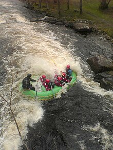
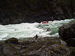
Rafting and whitewater rafting are recreational outdoor activities which use an inflatable raft to navigate a river or other body of water. This is often done on whitewater or different degrees of rough water. Dealing with risk is often a part of the experience.

<span class="mw-page-title-main">Whitewater</span> Turbulent and aerated water

Whitewater forms in the context of rapids, in particular, when a river's gradient changes enough to generate so much turbulence that air is trapped within the water. This forms an unstable current that froths, making the water appear opaque and white.

<span class="mw-page-title-main">Whitewater kayaking</span> Type of water sport

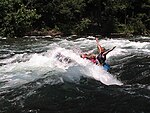
Whitewater kayaking is an adventure sport where a river is navigated in a decked kayak. Whitewater kayaking includes several styles. River running; where the paddler follows a river and paddles rapids as they travel. Creeking usually involving smaller, steeper, and more technical waterways. Creek boats tend to be short but high volume to allow for manoeuvrability while maintaining buoyancy. Slalom requires paddlers to navigate through "gates". Slalom is the only whitewater event to be in the Olympics. Play boating involves staying on one feature of the river and is more artistic than the others. Squirt boating uses low-volume boats to perform special moves in whitewater features.

<span class="mw-page-title-main">Watauga River</span> River in the United States of America

The Watauga River is a large stream of western North Carolina and East Tennessee. It is 78.5 miles (126.3 km) long with its headwaters in Linville Gap to the South Fork Holston River at Boone Lake.

<span class="mw-page-title-main">Afon Tryweryn</span> River in the United Kingdom

The Tryweryn is a river in the north of Wales which starts at Llyn Tryweryn in the Snowdonia National Park and after 19 kilometres (12 mi) joins the river Dee at Bala. One of the main tributaries of the Dee, it was dammed in 1965 to form Llyn Celyn. The Tryweryn flooding forcibly removed residents of the village of Capel Celyn despite popular and political opposition in Wales. The resulting graffiti "Cofiwch Dryweryn" near Llanrhystud became and remains a popular icon of Welsh feeling. Water is stored in Llyn Celyn in winter when flows are high, and released over the summer to maintain the flow in the Dee (water from the Dee is used as the water supply for large areas of north-east Wales, and for the Wirral and much of Liverpool in England.

Whitewater recreation in British Columbia is available in most of the province. Except for north-central and northeast British Columbia, the province is mostly mountainous with many glacial fed rivers draining though steep terrain creating excellent whitewater. Most commercial whitewater operations in British Columbia are rafting outfitters. However the provinces rivers are also well known to be good for whitewater kayaking, whitewater canoeing and river surfing although these activities are often done unguided.

<span class="mw-page-title-main">Green River (North Carolina)</span> Stream in North Carolina, USA

The Green River is a dam-release river that flows through the mountains of North Carolina, south of Asheville. The Green has numerous tributaries, but much of its water flows from a confluence with Big Hungry Creek. The Green River is itself a tributary of the Broad River. The river is dammed to form Lake Summit, in Tuxedo, North Carolina, and Lake Adger near Mill Spring, NC. The Green River is named for its deep green color but runs brown after heavy rains.

<span class="mw-page-title-main">Kananaskis River</span> River in Alberta, Canada

The Kananaskis River is a mountain river in western Alberta, Canada. It is a tributary of the Bow River, crossing the length of Kananaskis Country.

<span class="mw-page-title-main">Canolfan Tryweryn</span> White water sports venue near Bala, Wales

Canolfan Tryweryn is the National White Water Centre for Wales, and is based near Bala in north Wales. In 1986, it developed the first commercial white water rafting operation in the UK. The centre is home to paddlesport National Governing Body Canoe Wales.

<span class="mw-page-title-main">Creeking</span> Canoeing and kayaking involving the descent of waterfalls and slides

Creeking is a branch of canoeing and kayaking that involves descending very steep low-volume whitewater. It is usually performed in specialized canoes and kayaks specifically designed to withstand the extreme whitewater environment in which the activity occurs. In addition, the canoes and kayaks give the paddler improved performance and maneuverability needed to avoid river obstacles.

<span class="mw-page-title-main">Wairoa River (Bay of Plenty)</span> River in New Zealand

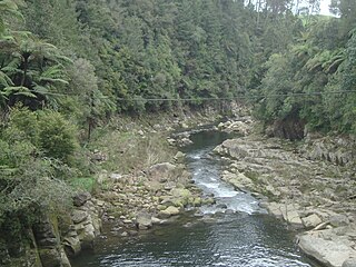
The Wairoa River runs north into Tauranga Harbour at the western end of the Bay of Plenty in New Zealand's North Island.

<span class="mw-page-title-main">Bee Cliff (Tennessee)</span>

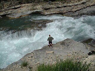
The Bee Cliff is a prominent northeast Tennessee geological limestone feature with high caves that overlooks the Watauga River and the Siam community of Carter County, Tennessee.

<span class="mw-page-title-main">Upper Dart</span>

Upper Dart is a section of the River Dart, Dartmoor. It is perhaps the second most popular section of whitewater for kayakers and canoeists in England, particularly for experienced paddlers. This section is followed on by the Dart Loop.

<span class="mw-page-title-main">Grand Canyon of the Stikine</span> Steep-sided canyon carved by the Stikine River in British Columbia, Canada

The Grand Canyon of the Stikine is a 72 km (45 mi) stretch of the Stikine River in northern British Columbia, Canada. It has been compared to the Grand Canyon of the Colorado. The canyon is home to a large population of mountain goats and other wildlife. Officially the canyon is described as unnavigable by any watercraft, however there have been numerous successful descents made by expert whitewater paddlers since the first attempt in 1981. Since it was first attempted, the Grand Canyon of the Stikine has maintained a legendary reputation among whitewater experts as the 'Mt. Everest' of big water expedition whitewater boating against which all other navigable rivers are measured.

<span class="mw-page-title-main">Whitewater canoeing</span> Paddling a canoe on a moving body of water

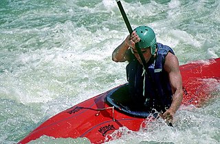
Whitewater canoeing is the sport of paddling a canoe on a moving body of water, typically a whitewater river. Whitewater canoeing can range from simple, carefree gently moving water, to demanding, dangerous whitewater. River rapids are graded like ski runs according to the difficulty, danger or severity of the rapid. Whitewater grades range from I or 1 to VI or 6. Grade/Class I can be described as slightly moving water with ripples. Grade/Class VI can be described as severe or almost unrunnable whitewater, such as Niagara Falls.

<span class="mw-page-title-main">Boonton Gorge</span>

The Boonton Gorge is a river gorge in Boonton, New Jersey where the Rockaway River drops over several waterfalls, and travels for slightly over a mile before emptying into the Jersey City Reservoir.

<span class="mw-page-title-main">Outline of canoeing and kayaking</span> Overview of and topical guide to canoeing and kayaking

Canoeing – recreational boating activity or paddle sport in which you kneel or sit facing forward in an open or closed-decked canoe, and propel yourself with a single-bladed paddle, under your own power.

References

  1. 1 2 Charlie Walbridge; Mark Singleton (2005). "Safety Code of American Whitewater". American Whitewater. Retrieved January 7, 2015.
  2. "International Scale of River Difficulty". American Whitewater. Retrieved January 7, 2015.
  3. "whitewater scale organisation". Deutscher Kanuverband. Archived from the original on April 20, 2016. Retrieved April 19, 2016.
  4. "whitewater scale DKV" (PDF). Deutscher Kanuverband. 1979. Archived from the original (PDF) on May 28, 2016. Retrieved April 19, 2016.
  5. Cassady, Jim; Fryar Calhoun; Bill Cross (1994). Western whitewater: from the Rockies to the Pacific, a river guide for raft, kayak, and canoe. Berkeley, CA: North Fork Press. ISBN   9780961365042.
  6. Ron Watters. "The Proposed Expanded Class I System of Rating Rivers". Proceedings of the 1999 International Conference on Outdoor Recreation and Education. Idaho State University. Archived from the original on June 24, 2018. Retrieved September 1, 2010.