Erosion is the action of surface processes that removes soil, rock, or dissolved material from one location on the Earth's crust and then transports it to another location where it is deposited. Erosion is distinct from weathering which involves no movement. Removal of rock or soil as clastic sediment is referred to as physical or mechanical erosion; this contrasts with chemical erosion, where soil or rock material is removed from an area by dissolution. Eroded sediment or solutes may be transported just a few millimetres, or for thousands of kilometres.
Crop rotation is the practice of growing a series of different types of crops in the same area across a sequence of growing seasons. This practice reduces the reliance of crops on one set of nutrients, pest and weed pressure, along with the probability of developing resistant pests and weeds.
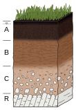
Soil erosion is the denudation or wearing away of the upper layer of soil. It is a form of soil degradation. This natural process is caused by the dynamic activity of erosive agents, that is, water, ice (glaciers), snow, air (wind), plants, and animals. In accordance with these agents, erosion is sometimes divided into water erosion, glacial erosion, snow erosion, wind (aeolian) erosion, zoogenic erosion and anthropogenic erosion such as tillage erosion. Soil erosion may be a slow process that continues relatively unnoticed, or it may occur at an alarming rate causing a serious loss of topsoil. The loss of soil from farmland may be reflected in reduced crop production potential, lower surface water quality and damaged drainage networks. Soil erosion could also cause sinkholes.

Stormwater, also written storm water, is water that originates from precipitation (storm), including heavy rain and meltwater from hail and snow. Stormwater can soak into the soil (infiltrate) and become groundwater, be stored on depressed land surface in ponds and puddles, evaporate back into the atmosphere, or contribute to surface runoff. Most runoff is conveyed directly as surface water to nearby streams, rivers or other large water bodies without treatment.

Dryland farming and dry farming encompass specific agricultural techniques for the non-irrigated cultivation of crops. Dryland farming is associated with drylands, areas characterized by a cool wet season followed by a warm dry season. They are also associated with arid conditions, areas prone to drought and those having scarce water resources.

Agricultural wastewater treatment is a farm management agenda for controlling pollution from confined animal operations and from surface runoff that may be contaminated by chemicals in fertilizer, pesticides, animal slurry, crop residues or irrigation water. Agricultural wastewater treatment is required for continuous confined animal operations like milk and egg production. It may be performed in plants using mechanized treatment units similar to those used for industrial wastewater. Where land is available for ponds, settling basins and facultative lagoons may have lower operational costs for seasonal use conditions from breeding or harvest cycles. Animal slurries are usually treated by containment in anaerobic lagoons before disposal by spray or trickle application to grassland. Constructed wetlands are sometimes used to facilitate treatment of animal wastes.
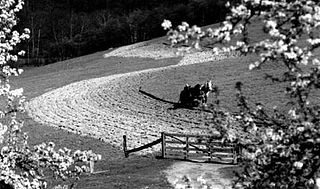
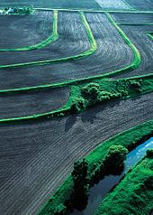
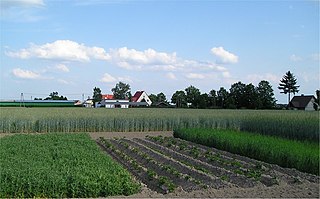
Contour bunding or contour farming or Contour ploughing is the farming practice of plowing and/or planting across a slope following its elevation contour lines. These contour lines create a water break which reduces the formation of rills and gullies during times of heavy precipitation, allowing more time for the water to settle into the soil. In contour plowing, the ruts made by the plow run perpendicular rather than parallel to the slopes, generally furrows that curve around the land and are level. This method is also known for preventing tillage erosion. Tillage erosion is the soil movement and erosion by tilling a given plot of land. A similar practice is contour bunding where stones are placed around the contours of slopes. Contour ploughing has been proved to reduce fertilizer loss, power and time consumption, and wear on machines, as well as to increase crop yields and reduces soil erosion.

Soil conservation is the prevention of loss of the topmost layer of the soil from erosion or prevention of reduced fertility caused by over usage, acidification, salinization or other chemical soil contamination.

In agriculture, a living mulch is a cover crop interplanted or undersown with a main crop, and intended to serve the purposes of a mulch, such as weed suppression and regulation of soil temperature. Living mulches grow for a long time with the main crops, whereas cover crops are incorporated into the soil or killed with herbicides.

Nonpoint source (NPS) pollution refers to diffuse contamination of water or air that does not originate from a single discrete source. This type of pollution is often the cumulative effect of small amounts of contaminants gathered from a large area. It is in contrast to point source pollution which results from a single source. Nonpoint source pollution generally results from land runoff, precipitation, atmospheric deposition, drainage, seepage, or hydrological modification where tracing pollution back to a single source is difficult. Nonpoint source water pollution affects a water body from sources such as polluted runoff from agricultural areas draining into a river, or wind-borne debris blowing out to sea. Nonpoint source air pollution affects air quality, from sources such as smokestacks or car tailpipes. Although these pollutants have originated from a point source, the long-range transport ability and multiple sources of the pollutant make it a nonpoint source of pollution; if the discharges were to occur to a body of water or into the atmosphere at a single location, the pollution would be single-point.

Surface runoff is the unconfined flow of water over the ground surface, in contrast to channel runoff. It occurs when excess rainwater, stormwater, meltwater, or other sources, can no longer sufficiently rapidly infiltrate in the soil. This can occur when the soil is saturated by water to its full capacity, and the rain arrives more quickly than the soil can absorb it. Surface runoff often occurs because impervious areas do not allow water to soak into the ground. Furthermore, runoff can occur either through natural or human-made processes.

An hydrological transport model is a mathematical model used to simulate the flow of rivers, streams, groundwater movement or drainage front displacement, and calculate water quality parameters. These models generally came into use in the 1960s and 1970s when demand for numerical forecasting of water quality and drainage was driven by environmental legislation, and at a similar time widespread access to significant computer power became available. Much of the original model development took place in the United States and United Kingdom, but today these models are refined and used worldwide.
Area sources are sources of pollution which emit a substance or radiation from a specified area.
Regarding the civil engineering of shorelines, soft engineering is a shoreline management practice that uses sustainable ecological principles to restore shoreline stabilization and protect riparian habitats. Soft Shoreline Engineering (SSE) uses the strategic placement of organic materials such as vegetation, stones, sand, debris, and other structural materials to reduce erosion, enhance shoreline aesthetic, soften the land-water interface, and lower costs of ecological restoration.

A buffer strip is an area of land maintained in permanent vegetation that helps to control air quality, soil quality, and water quality, along with other environmental problems, dealing primarily on land that is used in agriculture. Buffer strips trap sediment, and enhance filtration of nutrients and pesticides by slowing down surface runoff that could enter the local surface waters. The root systems of the planted vegetation in these buffers hold soil particles together which alleviate the soil of wind erosion and stabilize stream banks providing protection against substantial erosion and landslides. Farmers can also use buffer strips to square up existing crop fields to provide safety for equipment while also farming more efficiently.

A riparian buffer or stream buffer is a vegetated area near a stream, usually forested, which helps shade and partially protect the stream from the impact of adjacent land uses. It plays a key role in increasing water quality in associated streams, rivers, and lakes, thus providing environmental benefits. With the decline of many aquatic ecosystems due to agriculture, riparian buffers have become a very common conservation practice aimed at increasing water quality and reducing pollution.
The Universal Soil Loss Equation (USLE) is a widely used mathematical model that describes soil erosion processes.
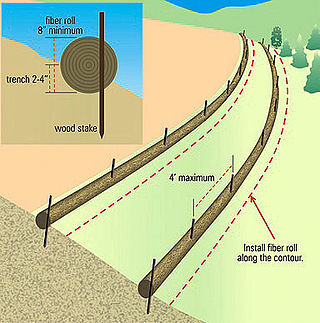
A fiber roll is a temporary erosion control and sediment control device used on construction sites to protect water quality in nearby streams, rivers, lakes and seas from sediment erosion. It is made of straw, coconut fiber or similar material formed into a tubular roll.

Filter strips, also referred to as buffer strips, are small, edge-of-field tracts of vegetated land that are used to reduce the contamination of surface water. They are primarily used in agriculture to control non-point source pollution, however, they may also be used to reduce sediment in storm water runoff from construction sites. There are several types of filter strips including vegetative filter strips, forested riparian buffers, and wind buffers. In agriculture, they are highly effective in reducing the concentration of nitrogen (N) and phosphorus (P) in runoff into surface water and are also effective in reducing sediment erosion and removing pesticides. This helps to prevent eutrophication and associated fishkills and loss of biodiversity. The use of filter strips is very common in developed countries and is required by law in some areas. The implementation and maintenance of filter strips is inexpensive and their use has been shown to be cost effective.

The May Sho’ate is a river of the Nile basin. Rising in the mountains of Dogu’a Tembien in northern Ethiopia, it flows southward to empty finally in Giba and Tekezé River.