Palaeochannel

Last updated

Aerial view of exhumed fluvial palaeochannel, Emery County, Utah. The erosion of softer surrounding mudstone left this palaeochannel as a sandstone ridge. Exhumed Paleochannel, Emery County, Utah2.jpg
Aerial view of exhumed fluvial palaeochannel, Emery County, Utah. The erosion of softer surrounding mudstone left this palaeochannel as a sandstone ridge.

In the Earth sciences, a palaeochannel, also spelled paleochannel, is a significant length of a river or stream channel which no longer conveys fluvial discharge as part of an active fluvial system. The term palaeochannel is derived from the combination of two words, palaeo or old, and channel ; i.e., a palaeochannel is an old channel. Palaeochannels may be preserved either as abandoned surface channels on the surface of river floodplains and terraces or infilled and partially or fully buried by younger sediments. The fill of a palaeochannel and its enclosing sedimentary deposits may consist of unconsolidated, semi-consolidated, or well-cemented sedimentary strata depending on the action of tectonics and diagenesis during their geologic history after deposition. The abandonment of an active fluvial channel and the resulting formation of a palaeochannel can be the result of tectonic processes, geomorphologic processes, anthropogenic activities, climatic changes, or a variable and interrelated combination of these factors. [2] [3]

Contents

Palaeochannel versus palaeovalley

In practice, the term palaeochannel has often been used both interchangeably and inconsistently with the terms palaeovalley and paleovalley. This has led to both potential and actual confusion in the published literature and studies of groundwater and mineral resources associated with palaeochannels. [4] [5] First, this distinction is important because not all valleys and palaeovalleys are fluvial in origin. Some of them may be either of glacial or tectonic origin. [4] Other palaeovalleys are buried submarine canyons cut by turbidity currents and mass wasting. [6] Second, even the deposits that fill a fluvial palaeovalley are not always fluvial sediments. Often, fluvial palaeovalleys are filled and buried by some combination of fluvial, volcanic, glacial, aeolian, lacustrine, estuarine, or marine deposits. [4] Finally, even when filled largely by fluvial sediments, the channel deposits that fill a palaeochannel comprise only a small fraction of a valley fill, which mainly consists of the deposits of other fluvial environments. [7] The nomenclature of palaeochannels must reflect their actual physical character, origin, and evolution if their relationship to mineral and groundwater resources is to be properly understood. [4] [5] Thus, it is recommended [4] [5] [8] that palaeochannel be used for an inactive channel formed by a river; palaeochannel deposits for the sediments that infill a palaeochannel; and palaeovalley for a valley incised by an ancient river.

Formation

The avulsion of an active river or stream is the most common fluvial process resulting in the formation of palaeochannels. It is the process by which flow diverts out of an established river channel into a new permanent course on the adjacent floodplain. An avulsion can be either a full avulsion, in which in which all of the discharge is transferred out of the parent channel to a new one, or partial avulsion, in which only a portion of the discharge is transferred to a new one. Only the full avulsion results the formation of a palaeochannel. Partial avulsions result in the formation of anastomosing channels when the divided active channels rejoin downstream and distributary channels when the divided active channels do not rejoin downstream. [9]

At least three broadly different types of avulsions, (a) avulsion by annexation; (b) avulsion by incision; and (c) avulsion by progradation, are recognized. First, an avulsion by annexation is an avulsion in which an existing active channel is appropriated or if an existing abandoned channel is reoccupied. Second, an avulsion by incision is an avulsion in which a new channel is created by the scouring into the floodplain surface as a direct result of the avulsion. Finally, an avulsion by progradation is an avulsion that results in the formation of an extensive deposition and multi-channeled distributive network. Of these types of avulsions only the avulsion by incision results in the complete abandonment and preservation of a fluvial channel as a palaeochannel. [9]

The exact environmental conditions that favour incisional avulsions remain unsettled. However, it is generally agreed that they are promoted by a) rapid aggradation of the main channel and floodplain; b) wide unobstructed floodplain and down-valley drainage; and c) frequently recurring floods of high magnitude. In many floodplains, these conditions and frequent avulsions are correlated with superelevated alluvial ridges and river stages. [9]

The event or factor that can trigger a specific avulsion may be either external or internal to a river system and quite varied. Factors external to a river system that might cause an avulsion include fault activity, sea-level rise, or an increase in flood peak discharge. Factors internal to a river system that might cause an avulsion include sediment influx, breakout along animal pathways, and blockage by ice jams, plant growth, log jams, and beaver dams. [10]

Recognition

A variety of techniques have been used to recognize and map palaeochannels. At first, surficial data from aerial photography, soils maps, topographic maps, archaeological surveys and excavations, and field observations were integrated with subsurface data from geological and engineering borings and cores to recognize and map palaeochannels. [11] [12] As the importance of coarse-grained fluvial deposits associated with palaeochannels as sources of groundwater and favoured conveyance of subsurface water became appreciated, geophysical techniques sensing the physical properties of underlying ground and bedrock and groundwater and other fluids contained within them became more important and widely used. [13] [14] For example, palaeochannels can be identified using airborne electromagnetic surveys, as the coarse-grained sediments are more electrically resistive than surrounding materials. [15] Also, lidar, more sophisticated remote sensing techniques, digital analysis, including computer modeling, of data were added to the various techniques used to detect and map palaeochannels. [14]

Geological importance

Palaeochannels are important to the Earth sciences because the palaeohydrology of the prehistoric rivers that created them can be reconstructed from their morphology, and the sediments or sedimentary rocks filling palaeochannels often contain dateable material, fossils, and palaeoenvironmental proxies. The data derived from the analysis of their morphology and the fossils and palaeoenvironmental proxies can be used to study changes in regional palaeohydrology, palaeoclimates, and palaeoenvironments over geological and historic time scales. [16] The morphology and distribution of palaeochannels can also be used to reconstruct the types, prehistory, and geometry of tectonic deformation, such as faulting, folding, uplift, and subsidence within an area. [17]

Palaeochannels often preserve the form, width, and sinuosity of prehistoric river channels when they were active. This is important in reconstructing prehistoric climate and hydrology because empirical equations developed using data collected from modern rivers and streams can be used to calculate the approximate past hydrologic regime of a palaeochannel and the palaeoclimate associated with it. Such empirical equations also allow the estimation of palaeochannel gradient, meander wavelength, sinuosity, and discharge from a palaeochannel exposed in cross-section in an outcrop. [18] [19] [20] The sediments or sedimentary rocks filling palaeochannels also often contain dateable material, micro- and megafossils, and palaeoenvironmental proxies. Fine-grained palaeochannel fills containing autochthonous vertebrate fossils may, in extremely favourable ccircumstances, contain unabraded, complete skeletons that are important for understanding habitat-specific palaeofaunas and associated palaeoenvironments. [21] [22] Fine-grained palaeochannel fills also frequently contain wood, leaves, and palynomorphs that can be used for geologic dating and understanding palaeoclimatic and other palaeoenvironmental conditions, including past rainfall, temperatures and climates, and prehistoric and historic climate change and global warming. [23] [24] Finally, the theoretical equilibrium profiles of rivers and streams provide a datum by which to detect and quantify tectonic processes such as faulting, uplift, and subsidence. Examples of the displacement of palaeochannels by active faulting are shown by the lateral movement along the San Andreas fault where it crosses Wallace Creek in central California, [25] [26] and where a fault of the Baton Rouge fault zone vertically offsets a Pleistocene palaeochannel and palaeo-floodplain of the Amite River near Denham Springs, Louisiana. [27]

Palaeochannel-hosted mineral deposits

Economically important mineral deposits may be hosted in palaeochannels and associated fluvial deposits. The most important of these deposits are syndepositional palaeo-placer deposits containing gold, [28] [29] cassiterite (tin ore), [30] and platinum group minerals. [31] In addition, diagenetic and postdepositional ores of uranium [32] and iron [33] have been found in palaeochannel fills.

Although layers of lignite and other types of coal are sometimes part of the sedimentary fill of palaeochannels, they are typically too thin and narrow to be economically mined. Also, they actually occur in palaeovalleys, which have been mislabeled as palaeochannels. Typically, when palaeochannels formed, they often partially or totally removed any underlying peat, the precursor to coal. Thus, where present, they are directly associated with areas of thin or missing coal called either wash-outs or coal wants. Wash-outs are a major problem for coal mining because of the drastic decrease in the total tonnage of mineable coal, and disruption to mining techniques. Also, bedding and jointing within strata comprising palaeochannels typically result in hazardous conditions related to unstable highwalls in opencast mines and collapsable roof rock in coal adits. [34] [35] [36]

Palaeochannels and aquifers

Coarse-grained (sandy) palaeochannels and palaeovalleys have been proposed as reservoirs or conduits for the preferential underground flow of fresh water. When they extend offshore beneath the continental shelf, they may either transfer freshwater offshore beneath the shelf, or act as pathways for saltwater intrusion into onshore aquifers. Smaller palaeochannels and palaeovalleys, which are commonly filled with muddy or clayey sediments can act as aquicludes that retard and act as barriers to the movement of groundwater. [37]

See also

Related Research Articles

<span class="mw-page-title-main">Sedimentary rock</span> Rock formed by the deposition and cementation of particles

Sedimentary rocks are types of rock that are formed by the accumulation or deposition of mineral or organic particles at Earth's surface, followed by cementation. Sedimentation is the collective name for processes that cause these particles to settle in place. The particles that form a sedimentary rock are called sediment, and may be composed of geological detritus (minerals) or biological detritus. The geological detritus originated from weathering and erosion of existing rocks, or from the solidification of molten lava blobs erupted by volcanoes. The geological detritus is transported to the place of deposition by water, wind, ice or mass movement, which are called agents of denudation. Biological detritus was formed by bodies and parts of dead aquatic organisms, as well as their fecal mass, suspended in water and slowly piling up on the floor of water bodies. Sedimentation may also occur as dissolved minerals precipitate from water solution.

<span class="mw-page-title-main">Alluvial fan</span> Fan-shaped deposit of sediment

An alluvial fan is an accumulation of sediments that fans outwards from a concentrated source of sediments, such as a narrow canyon emerging from an escarpment. They are characteristic of mountainous terrain in arid to semiarid climates, but are also found in more humid environments subject to intense rainfall and in areas of modern glaciation. They range in area from less than 1 square kilometer (0.4 sq mi) to almost 20,000 square kilometers (7,700 sq mi).

The Llano Uplift is a geologically ancient, low geologic dome that is about 90 miles (140 km) in diameter and located mostly in Llano, Mason, San Saba, Gillespie, and Blanco counties, Texas. It consists of an island-like exposure of Precambrian igneous and metamorphic rocks surrounded by outcrops of Paleozoic and Cretaceous sedimentary strata. At their widest, the exposed Precambrian rocks extend about 65 miles (105 km) westward from the valley of the Colorado River and beneath a broad, gentle topographic basin drained by the Llano River. The subdued topographic basin is underlain by Precambrian rocks and bordered by a discontinuous rim of flat-topped hills. These hills are the dissected edge of the Edwards Plateau, which consist of overlying Cretaceous sedimentary strata. Within this basin and along its margin are down-faulted blocks and erosional remnants of Paleozoic strata which form prominent hills.

<span class="mw-page-title-main">Geology of the Zion and Kolob canyons area</span> Geology of Zion National Park in Utah

The geology of the Zion and Kolob canyons area includes nine known exposed formations, all visible in Zion National Park in the U.S. state of Utah. Together, these formations represent about 150 million years of mostly Mesozoic-aged sedimentation in that part of North America. Part of a super-sequence of rock units called the Grand Staircase, the formations exposed in the Zion and Kolob area were deposited in several different environments that range from the warm shallow seas of the Kaibab and Moenkopi formations, streams and lakes of the Chinle, Moenave, and Kayenta formations to the large deserts of the Navajo and Temple Cap formations and dry near shore environments of the Carmel Formation.

<span class="mw-page-title-main">Conglomerate (geology)</span> Sedimentary rock composed of smaller rock fragments

Conglomerate is a clastic sedimentary rock that is composed of a substantial fraction of rounded to subangular gravel-size clasts. A conglomerate typically contains a matrix of finer-grained sediments, such as sand, silt, or clay, which fills the interstices between the clasts. The clasts and matrix are typically cemented by calcium carbonate, iron oxide, silica, or hardened clay.

<span class="mw-page-title-main">Polystrate fossil</span> Creationist term for a fossil that extends through more than one geological stratum

A polystrate fossil is a fossil of a single organism that extends through more than one geological stratum. The word polystrate is not a standard geological term. This term is typically found in creationist publications.

<span class="mw-page-title-main">Aggradation</span> Increase in land elevation due of the deposition of sediment

Aggradation is the term used in geology for the increase in land elevation, typically in a river system, due to the deposition of sediment. Aggradation occurs in areas in which the supply of sediment is greater than the amount of material that the system is able to transport. The mass balance between sediment being transported and sediment in the bed is described by the Exner equation.

An overbank is an alluvial geological deposit consisting of sediment that has been deposited on the floodplain of a river or stream by flood waters that have broken through or overtopped the banks. The sediment is carried in suspension, and because it is carried outside of the main channel, away from faster flow, the sediment is typically fine-grained. An overbank deposit usually consists primarily of fine sand, silt and clay. Overbank deposits can be beneficial because they refresh valley soils.

<span class="mw-page-title-main">Crevasse splay</span> Sediment deposited on a floodplain by a stream which breaks its levees

A crevasse splay is a sedimentary fluvial deposit which forms when a stream breaks its natural or artificial levees and deposits sediment on a floodplain. A breach that forms a crevasse splay deposits sediments in similar pattern to an alluvial fan deposit. Once the levee has been breached the water flows out of its channel. As the water spreads onto the flood plain sediments will start to fall out of suspension as the water loses energy. The resulting deposition can create graded deposits similar to those found in Bouma sequences. In some cases crevasse splays can cause a river to abandon its old river channel, a process known as avulsion. Breaches that form a crevasse splay deposits occur most commonly on the outside banks of meanders where the water has the highest energy. Crevasse splay deposits can range in size. Larger deposits can be 6 m (20 ft) thick at the levee and spread 2 km (1.2 mi) wide, while smaller deposits may only be 1 cm (0.39 in) thick.

<span class="mw-page-title-main">Exhumed river channel</span> Ridge of sandstone that remains when the softer flood plain mudstone is eroded away

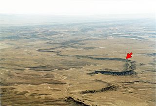
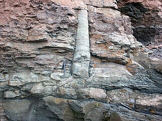
An exhumed river channel is a ridge of sandstone that remains when the softer flood plain mudstone is eroded away. The process begins with the deposition of sand within a river channel and mud on the adjacent floodplain. Eventually the channel is abandoned and over time becomes buried by flood deposits from other channels. Because the sand is porous, groundwater flows more easily through the sand than through the mud of the floodplain deposits.

<span class="mw-page-title-main">Uranium ore</span> Economically recoverable concentrations of uranium within the Earths crust

Uranium ore deposits are economically recoverable concentrations of uranium within the Earth's crust. Uranium is one of the most common elements in the Earth's crust, being 40 times more common than silver and 500 times more common than gold. It can be found almost everywhere in rock, soil, rivers, and oceans. The challenge for commercial uranium extraction is to find those areas where the concentrations are adequate to form an economically viable deposit. The primary use for uranium obtained from mining is in fuel for nuclear reactors.

<span class="mw-page-title-main">Avulsion (river)</span> Rapid abandonment of a river channel and formation of a new channel

In sedimentary geology and fluvial geomorphology, avulsion is the rapid abandonment of a river channel and the formation of a new river channel. Avulsions occur as a result of channel slopes that are much less steep than the slope that the river could travel if it took a new course.

<span class="mw-page-title-main">Inverted relief</span> Landscape features that have reversed their elevation relative to other features

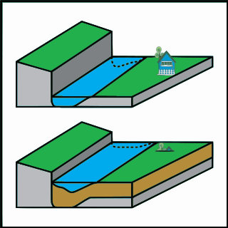
Inverted relief, inverted topography, or topographic inversion refers to landscape features that have reversed their elevation relative to other features. It most often occurs when low areas of a landscape become filled with lava or sediment that hardens into material that is more resistant to erosion than the material that surrounds it. Differential erosion then removes the less resistant surrounding material, leaving behind the younger resistant material, which may then appear as a ridge where previously there was a valley. Terms such as "inverted valley" or "inverted channel" are used to describe such features. Inverted relief has been observed on the surfaces of other planets as well as on Earth. For example, well-documented inverted topographies have been discovered on Mars.

<span class="mw-page-title-main">Molteno Formation</span> Triassic geological formation in the Stormberg Group in Lesotho and South Africa

The Molteno Formation is a geological formation found in several localities in Lesotho and South Africa. It lies mainly south of Maseru, near Burgersdorp, Aliwal North, Dordrecht, Molteno, and Elliot. It extends as far north as Matatiele in the Eastern Cape. The formation's localities lie along the Drakensberg Mountains in Kwazulu-Natal, and near Ladybrand in the Free State of South Africa. The Molteno Formation is the lowermost of the three formations in the Stormberg Group of the greater Karoo Supergroup. The Molteno Formation represents the initial phase of preserved sedimentation of the Stormberg Group.

<span class="mw-page-title-main">Himalayan foreland basin</span> Active collisional foreland basin in South Asia

The Himalayan foreland basin is an active collisional foreland basin system in South Asia. Uplift and loading of the Eurasian Plate on to the Indian Plate resulted in the flexure (bending) of the Indian Plate, and the creation of a depression adjacent to the Himalayan mountain belt. This depression was filled with sediment eroded from the Himalaya, that lithified and produced a sedimentary basin ~3 to >7 km deep. The foreland basin spans approximately 2,000 kilometres (1,200 mi) in length and 450 kilometres (280 mi) in width. From west to east the foreland basin stretches across five countries: Pakistan, India, Nepal, Bangladesh, and Bhutan.

<span class="mw-page-title-main">Arauco Basin</span>

The Arauco Basin is a sediment-filled depression –a sedimentary basin– in south-central Chile. In the context of plate tectonics it is classified as a forearc basin. The basin has an approximate area of 8,000 square kilometres (3,100 sq mi) and at its deeper parts the surface of its sedimentary fill reaches 200 metres (660 ft) below sea-level. The basin is interpreted as being part of an uplifted part of the continental shelf. To the west it bounds an active accretionary prism that lies next to the Chile trench and to the east it bounds metamorphic basement representing a fossil Paleozoic accretionary complex that has been intruded by the Coastal Batholith of central Chile.

The geology of Malawi formed on extremely ancient crystalline basement rock, which was metamorphosed and intruded by igneous rocks during several orogeny mountain building events in the past one billion years. The rocks of the Karoo Supergroup and newer sedimentary units deposited across much of Malawi in the last 251 million years, in connection with a large rift basin on the supercontinent Gondwana and the more recent rifting that has created the East African Rift, which holds Lake Malawi. The country has extensive mineral reserves, many of them poorly understood or not exploited, including coal, vermiculite, rare earth elements and bauxite.

The geology of Mozambique is primarily extremely old Precambrian metamorphic and igneous crystalline basement rock, formed in the Archean and Proterozoic, in some cases more than two billion years ago. Mozambique contains greenstone belts and spans the Zimbabwe Craton, a section of ancient stable crust. The region was impacted by major tectonic events, such as the mountain building Irumide orogeny, Pan-African orogeny and the Snowball Earth glaciation. Large basins that formed in the last half-billion years have filled with extensive continental and marine sedimentary rocks, including rocks of the extensive Karoo Supergroup which exist across Southern Africa. In some cases these units are capped by volcanic rocks. As a result of its complex and ancient geology, Mozambique has deposits of iron, coal, gold, mineral sands, bauxite, copper and other natural resources.

<span class="mw-page-title-main">Geology of Arizona</span> Overview of the geology of Arizona

The geology of Arizona began to form in the Precambrian. Igneous and metamorphic crystalline basement rock may have been much older, but was overwritten during the Yavapai and Mazatzal orogenies in the Proterozoic. The Grenville orogeny to the east caused Arizona to fill with sediments, shedding into a shallow sea. Limestone formed in the sea was metamorphosed by mafic intrusions. The Great Unconformity is a famous gap in the stratigraphic record, as Arizona experienced 900 million years of terrestrial conditions, except in isolated basins. The region oscillated between terrestrial and shallow ocean conditions during the Paleozoic as multi-cellular life became common and three major orogenies to the east shed sediments before North America became part of the supercontinent Pangaea. The breakup of Pangaea was accompanied by the subduction of the Farallon Plate, which drove volcanism during the Nevadan orogeny and the Sevier orogeny in the Mesozoic, which covered much of Arizona in volcanic debris and sediments. The Mid-Tertiary ignimbrite flare-up created smaller mountain ranges with extensive ash and lava in the Cenozoic, followed by the sinking of the Farallon slab in the mantle throughout the past 14 million years, which has created the Basin and Range Province. Arizona has extensive mineralization in veins, due to hydrothermal fluids and is notable for copper-gold porphyry, lead, zinc, rare minerals formed from copper enrichment and evaporites among other resources.

<span class="mw-page-title-main">Geology of Colorado</span> Geology of the U.S. State of Colorado

The bedrock under the U.S. State of Colorado was assembled from island arcs accreted onto the edge of the ancient Wyoming Craton. The Sonoma orogeny uplifted the ancestral Rocky Mountains in parallel with the diversification of multicellular life. Shallow seas covered the regions, followed by the uplift current Rocky Mountains and intense volcanic activity. Colorado has thick sedimentary sequences with oil, gas and coal deposits, as well as base metals and other minerals.

References

  1. Hayden, A.T., Lamb, M.P., Fischer, W.W., Ewing, R.C., McElroy, B.J. and Williams, R.M., 2019. Formation of sinuous ridges by inversion of river-channel belts in Utah, USA, with implications for Mars. Icarus, 332, pp.92-110.
  2. Kumar, V., 2011. Palaeo-channel. In: Bishop, M.P., Björnsson, H., Haeberli, W., Oerlemans, J., Shroder, J.F. and Tranter, M., eds., p. 803, Encyclopedia of snow, ice and glaciers. Amsterdam, The Netherlands, Springer Science & Business Media. 1253 pp. ISBN   978-90-481-2641-5
  3. Nash, D.J., 2000. Palaeochannel. In Thomas, D.S.G., and Goudie, A., eds., p. 354. The Dictionary of Physical Geology, 3rd ed. Oxford, United Kingdom, Blackwell Publishing. 610 pp. ISBN   978-0-631-20472-5
  4. 1 2 3 4 5 Clarke, J., 2009. Palaeovalley, palaeodrainage, and palaeochannel–what’s the difference and why does it matter?. Transactions of the Royal Society of South Australia, 133(1), pp.57-61.
  5. 1 2 3 Munday, T., Taylor, A., Raiber, M., Soerensen, C., Peeters, L., Krapf, C., Cui, T., Cahill, K., Flinchum, B., Smolanko, N. and Martinez, J., 2020. Integrated regional hydrogeophysical conceptualization of the Musgrave Province, South Australia.Goyder Institute for Water Research Technical Report Series No. 20/04. Adelaide, SA, Australia, Goyder Institute for Water Research. 108 pp.
  6. Shepard, F.P., 1981. Submarine canyons: multiple causes and long-time persistence. American Association of Petroleum Geologist Bulletin, 65(6), pp.1062-1077.
  7. Gibling, M.R., Fielding, C.R., and Sinha, R., 2011. Alluvial valleys and alluvial sequences: towards a geomorphic assessment. In: North, C., Davidson, S., and Leleu, S. eds., pp. 423–447, Rivers to Rocks.Special Publication. 97. Tulsa, Oklahoma, SEPM (Society for Sedimentary Geology) 447 pp. ISBN   978-1-56576-305-0
  8. Long, J.H., Hanebuth, T.J., Alexander, C.R. and Wehmiller, J.F., 2021. Depositional environments and stratigraphy of Quaternary paleochannel systems offshore of the Georgia Bight, southeastern USA.Journal of Coastal Research, 37(5), pp.883-905.
  9. 1 2 3 Slingerland, R., and Smith, N.D., 2004. River avulsions and their deposits.Annual Review of Earth and Planetary Sciences, 32, pp.257-285.
  10. Gibling, M.R., Bashforth, A.R., Falcon-Lang, H.J., Allen, J.P. and Fielding, C.R., 2010. Log jams and flood sediment buildup caused channel abandonment and avulsion in the Pennsylvanian of Atlantic Canada.Journal of Sedimentary Research, 80(3), pp.268-287.
  11. Fisk, H.N., 1944. Geological Investigation of the Alluvial Valley of the Lower Mississippi River. Vicksburg, Mississippi, Mississippi River Commission and Washington, DC, War Department, U. S. Army Corps of Engineers. 78 pp.
  12. El Bastawesy, M., Gebremichael, E., Sultan, M., Attwa, M. and Sahour, H., 2020. Tracing Holocene channels and landforms of the Nile Delta through integration of early elevation, geophysical, and sediment core data.The Holocene , 30(8), pp.1129-1141.
  13. Nimnate, P., Thitimakorn, T., Choowong, M. and Hisada, K., 2017. Imaging and locating paleo-channels using geophysical data from meandering system of the Mun River, Khorat Plateau, Northeastern Thailand.Open Geosciences, 9(1), pp.675-688.
  14. 1 2 Kirsch, R., 2011. Groundwater Geophysics: A Tool for Hydrogeology, 2nd. Berlin, New York, Springer. 493 pp. ISBN   978-3-540-29383-5
  15. Knight, R., Steklova, K., Miltenberger, A., Kang, S., Goebel, M., and Fogg, G., 2022. Airborne geophysical method images fast paths for managed recharge of California’s groundwater.Environmental Research Letters, 17(12), no. 124021.
  16. Toonen, W.H., Kleinhans, M.G., and Cohen, K.M., 2012. Sedimentary architecture of abandoned channel fills.Earth surface processes and landforms , 37(4), pp.459-472.
  17. Peakall, J., 1998. Axial river evolution in response to half-graben faulting; Carson River, Nevada, USA.Journal of Sedimentary Research, 68(5), pp.788-799.
  18. Schumm, S.A., 1972. Fluvial paleochannels. in Rigby, J.K., and Hamblin, W.K., eds., pp. 98-107, Recognition of Ancient Sedimentary Environments. SEPM Special Publication, 16. Tulsa, Oklahoma, Society for Sedimentary Geology (SEPM). 340 pp. ISSN   0097-3270
  19. Williams, G.P., 1988. Paleofluvial estimates from dimensions of former channels and meanders. in Baker, V.R., Kochel, R.C., and Patton, P.C., eds., pp.321-334, Flood Geomorphology. New York, New York, John Wiley. 503 pp. ISBN   978-0-471-62558-2
  20. Sidorchuk, A.Y., and Borisova, O.K., 2000. Method of paleogeographical analogues in paleohydrological reconstructions.Quaternary International, 72(1), pp.95-106.
  21. Behrensmeyer, A.K., 1988. Vertebrate preservation in fluvial channels.Palaeogeography, Palaeoclimatology, Palaeoecology, 63(1-3), pp.183-199.
  22. Behrensmeyer, A.K., and Hook, R.W. 1992. Paleoenvironmental contexts and taphonomic modes in the terrestrial fossil record. in Behrensmeyer, A. K., Damuth, J. D., DiMichele, W. A., Potts, R., Sues, H.-D., and Wing, S.L., eds., pp. 15-136, Terrestrial Ecosystems Through Time. Chicago, Illinois, University of Chicago Press. 588 pp. ISBN   978-0-226-04155-1
  23. Gastaldo, R.A., and Demko, T.M., 2011. The relationship between continental landscape evolution and the plant-fossil record: long term hydrology controls the plant fossil record. in Allison, P.A., and Bottjer, D.J., eds., pp. 249- 286, Taphonomy, Second Edition: Processes and Bias Through Time. The Netherlands, Springer. 612 pp. ISBN   978-9-400-73403-6
  24. Simon, S., Gibling, M.R., DiMichele, W.A., Chaney, D.S., Looy, C.V. and Tabor, N.J., 2016. An abandoned-channel fill with exquisitely preserved plants in redbeds of the Clear Fork Formation, Texas, USA: an Early Permian water-dependent habitat on the arid plains of Pangea.Journal of Sedimentary Research, 86, 944–964.
  25. Sieh, K.E. and Jahns, R.H., 1984. Holocene activity of the San Andreas fault at Wallace creek, California.Geological Society of America Bulletin, 95(8), pp.883-896.
  26. Dascher-Cousineau, K., Finnegan, N.J., and Brodsky, E.E., 2021. The life span of fault-crossing channels.Science, 373(6551), pp.204-207.
  27. Shen, Z., Dawers, N.H., Törnqvist, T.E., Gasparini, N.M., Hijma, M.P. and Mauz, B., 2017. Mechanisms of late Quaternary fault throw rate variability along the north central Gulf of Mexico coast: Implications for coastal subsidence.Basin Research, 29(5), pp.557-570.
  28. Taylor, D.H., and Gentle, L.V., 2002. Evolution of deep‐lead palaeodrainages and gold exploration at Ballarat, Australia.Australian Journal of Earth Sciences, 49(5), pp.869-878.
  29. Garside, L.J., Henry, C.D., Faulds, J.E., Hinz, N.H., Rhoden, H.N., Steininger, R.C., and Vikre, P.G., 2005. The upper reaches of the Sierra Nevada auriferous gold channels, California and Nevada. in Rhoden, H.N., Steininger, R.C., and Vikre, P.G., eds., pp. 209-235, Geological Society of Nevada Symposium 2005: Window to the World, Reno, Nevada, May 2005. Reno, Nevada, Geological Society of Nevada.
  30. Lericolais, G., Berne, S., Hamzah, Y., Lallier, S., Mulyadi, W., Robach, F., and Sujitno, S., 1987. High-resolution seismic and magnetic exploration for tin deposits in Bangka, Indonesia.Marine Minerals, 6(1), pp.9-21.
  31. Slansky, E., Barron, L.M., Suppel, D., Johan, Z., and Ohnenstetter, M., 1991. Platinum mineralization in the Alaskan-type intrusive complexes near Fifield, NSW, Australia. Part 2. Platinum-group minerals in placer deposits at Fifield.Mineralogy and Petrology, 43(3), pp.161-180.
  32. Kumar, P., Panigrahi, B. and Joshi, G.B., 2016. Palaeochannel controlled Cretaceous sandstone-type uranium deposit of Lostoin area, Mahadek basin, Meghalaya.Journal of the Geological Society of India, 87(4), pp.424-428.
  33. Macphail, M.K. and Stone, M.S., 2004. Age and palaeoenvironmental constraints on the genesis of the Yandi channel iron deposits, Marillana Formation, Pilbara, northwestern Australia.Australian Journal of Earth Sciences, 51(4), pp.497-520.
  34. Jones, N.S., Guion, P.D., Fulton, I.M., 1995. Sedimentology and its applications within the UK opencast coal mining industry. in Whateley, M.K.G., and Spears, D.A., eds., pp. 115–135, European Coal Geology.Geological Society, London Special Publication, 82. London, England, Geological Society Publishing House. 331 pp. ISBN   978-1-786-20055-6
  35. Sames, G.P. and Laird, R.B., 1987. Geologic Conditions Affecting Coal Mine Ground Control in the Western United States.US Department of the Interior, Bureau of Mines Report, IC-9172. 30 pp.
  36. Kane, W.F., Milici, R.C. and Gathright, T.M., 1993. Geologic factors affecting coal mine roof stability in the eastern United States.Bulletin of the Association of Engineering Geologists, 30(2), pp.165-179.
  37. White, S.M., Smoak, E., Leier, A.L. and Wilson, A.M., 2023. Small Muddy Paleochannels and Implications for Submarine Groundwater Discharge near Charleston, South Carolina, USA.Geosciences, 13(8), no. 232.