Related Research Articles

Orogeny is a mountain-building process that takes place at a convergent plate margin when plate motion compresses the margin. An orogenic belt or orogen develops as the compressed plate crumples and is uplifted to form one or more mountain ranges. This involves a series of geological processes collectively called orogenesis. These include both structural deformation of existing continental crust and the creation of new continental crust through volcanism. Magma rising in the orogen carries less dense material upwards while leaving more dense material behind, resulting in compositional differentiation of Earth's lithosphere. A synorogenic process or event is one that occurs during an orogeny.
Obduction is a geological process whereby denser oceanic crust is scraped off a descending ocean plate at a convergent plate boundary and thrust on top of an adjacent plate. When oceanic and continental plates converge, normally the denser oceanic crust sinks under the continental crust in the process of subduction. Obduction, which is less common, normally occurs in plate collisions at orogenic belts or back-arc basins.
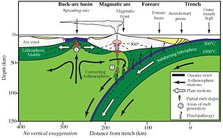
Forearc is a plate tectonic term referring to a region in a subduction zone between an oceanic trench and the associated volcanic arc. Forearc regions are present along convergent margins and eponymously form 'in front of' the volcanic arcs that are characteristic of convergent plate margins. A back-arc region is the companion region behind the volcanic arc.
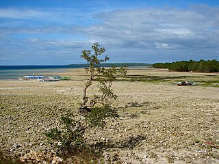
Tectonic uplift is the geologic uplift of Earth's surface that is attributed to plate tectonics. While isostatic response is important, an increase in the mean elevation of a region can only occur in response to tectonic processes of crustal thickening, changes in the density distribution of the crust and underlying mantle, and flexural support due to the bending of rigid lithosphere.
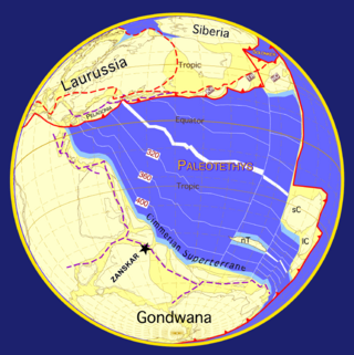
The geology of the Himalayas is a record of the most dramatic and visible creations of the immense mountain range formed by plate tectonic forces and sculpted by weathering and erosion. The Himalayas, which stretch over 2400 km between the Namcha Barwa syntaxis at the eastern end of the mountain range and the Nanga Parbat syntaxis at the western end, are the result of an ongoing orogeny — the collision of the continental crust of two tectonic plates, namely, the Indian Plate thrusting into the Eurasian Plate. The Himalaya-Tibet region supplies fresh water for more than one-fifth of the world population, and accounts for a quarter of the global sedimentary budget. Topographically, the belt has many superlatives: the highest rate of uplift, the highest relief, among the highest erosion rates at 2–12 mm/yr, the source of some of the greatest rivers and the highest concentration of glaciers outside of the polar regions. This last feature earned the Himalaya its name, originating from the Sanskrit for "the abode of the snow".

In geology, continental collision is a phenomenon of plate tectonics that occurs at convergent boundaries. Continental collision is a variation on the fundamental process of subduction, whereby the subduction zone is destroyed, mountains produced, and two continents sutured together. Continental collision is only known to occur on Earth.
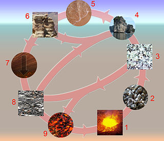
The rock cycle is a basic concept in geology that describes transitions through geologic time among the three main rock types: sedimentary, metamorphic, and igneous. Each rock type is altered when it is forced out of its equilibrium conditions. For example, an igneous rock such as basalt may break down and dissolve when exposed to the atmosphere, or melt as it is subducted under a continent. Due to the driving forces of the rock cycle, plate tectonics and the water cycle, rocks do not remain in equilibrium and change as they encounter new environments. The rock cycle explains how the three rock types are related to each other, and how processes change from one type to another over time. This cyclical aspect makes rock change a geologic cycle and, on planets containing life, a biogeochemical cycle.

The Grenville orogeny was a long-lived Mesoproterozoic mountain-building event associated with the assembly of the supercontinent Rodinia. Its record is a prominent orogenic belt which spans a significant portion of the North American continent, from Labrador to Mexico, as well as to Scotland.

Décollement is a gliding plane between two rock masses, also known as a basal detachment fault. Décollements are a deformational structure, resulting in independent styles of deformation in the rocks above and below the fault. They are associated with both compressional settings and extensional settings.

The interaction between erosion and tectonics has been a topic of debate since the early 1990s. While the tectonic effects on surface processes such as erosion have long been recognized, the opposite has only recently been addressed. The primary questions surrounding this topic are what types of interactions exist between erosion and tectonics and what are the implications of these interactions. While this is still a matter of debate, one thing is clear, Earth's landscape is a product of two factors: tectonics, which can create topography and maintain relief through surface and rock uplift, and climate, which mediates the erosional processes that wear away upland areas over time. The interaction of these processes can form, modify, or destroy geomorphic features on Earth's surface.
A river anticline is a geologic structure that is formed by the focused uplift of rock caused by high erosion rates from large rivers relative to the surrounding areas. An anticline is a fold that is concave down, whose limbs are dipping away from its axis, and whose oldest units are in the middle of the fold. These features form in a number of structural settings. In the case of river anticlines, they form due to high erosion rates, usually in orogenic settings. In a mountain building setting, like that of the Himalaya or the Andes, erosion rates are high and the river anticline's fold axis will trend parallel to a major river. When river anticlines form, they have a zone of uplift between 50-80 kilometers wide along the rivers that form them.
Ultra-high-pressure metamorphism refers to metamorphic processes at pressures high enough to stabilize coesite, the high-pressure polymorph of SiO2. It is important because the processes that form and exhume ultra-high-pressure (UHP) metamorphic rocks may strongly affect plate tectonics, the composition and evolution of Earth's crust. The discovery of UHP metamorphic rocks in 1984 revolutionized our understanding of plate tectonics. Prior to 1984 there was little suspicion that continental rocks could reach such high pressures.

Pre-collisional Himalaya is the arrangement of the Himalayan rock units before mountain-building processes resulted in the collision of Asia and India. The collision began in the Cenozoic and it is a type locality of a continental-continental collision. The reconstruction of the initial configuration of the rock units and the relationship between them is highly controversial, and major concerns relate to the arrangements of the different rock units in three dimensions. Several models have been advanced to explain the possible arrangements and petrogenesis of the rock units.

The Huangling Anticline or Complex represents a group of rock units that appear in the middle of the Yangtze Block in South China, distributed across Yixingshan, Zigui, Huangling, and Yichang counties. The group of rock involves nonconformity that sedimentary rocks overlie the metamorphic basement. It is a 73-km long, asymmetrical dome-shaped anticline with axial plane orientating in the north-south direction. It has a steeper west flank and a gentler east flank. Basically, there are three tectonic units from the anticline core to the rim, including Archean to Paleoproterozoic metamorphic basement, Neoproterozoic to Jurassic sedimentary rocks, and Cretaceous fluvial deposit sedimentary cover. The northern part of the core is mainly tonalite-trondhjemite-gneiss (TTG) and Cretaceous sedimentary rock called the Archean Kongling Complex. The middle of the core is mainly the Neoproterozoic granitoid. The southern part of the core is the Neoproterozoic potassium granite. Two basins are situated on the western and eastern flanks of the core, respectively, including the Zigui basin and Dangyang basin. Both basins are synforms while Zigui basin has a larger extent of folding. Yuanan Graben and Jingmen Graben are found within the Dangyang Basin area. The Huangling Anticline is an important area that helps unravel the tectonic history of the South China Craton because it has well-exposed layers of rock units from Archean basement rock to Cretaceous sedimentary rock cover due to the erosion of the anticline.

In geology, orogenic collapse is the thinning and lateral spread of thickened crust. It is a broad term referring to processes which distribute material from regions of high gravitational potential energy to regions of low gravitational potential energy. Orogenic collapse can begin at any point during an orogeny due to overthickening of the crust. Post-orogenic collapse and post-orogenic extension refer to processes which take place once tectonic forces have been released, and represent a key phase of the Wilson Cycle, between continental collision and rifting.

The Scandinavian Caledonides are the vestiges of an ancient, today deeply eroded orogenic belt formed during the Silurian–Devonian continental collision of Baltica and Laurentia, which is referred to as the Scandian phase of the Caledonian orogeny. The size of the Scandinavian Caledonides at the time of their formation can be compared with the size of the Himalayas. The area east of the Scandinavian Caledonides, including parts of Finland, developed into a foreland basin where old rocks and surfaces were covered by sediments. Today, the Scandinavian Caledonides underlay most of the western and northern Scandinavian Peninsula, whereas other parts of the Caledonides can be traced into West and Central Europe as well as parts of Greenland and eastern North America.
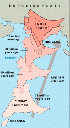
The paleogeography of the India–Asia collision system is the reconstructed geological and geomorphological evolution within the collision zone of the Himalayan orogenic belt. The continental collision between the Indian and Eurasian plate is one of the world's most renowned and most studied convergent systems. However, many mechanisms remain controversial. Some of the highly debated issues include the onset timing of continental collision, the time at which the Tibetan plateau reached its present elevation and how tectonic processes interacted with other geological mechanisms. These mechanisms are crucial for the understanding of Mesozoic and Cenozoic tectonic evolution, paleoclimate and paleontology, such as the interaction between the Himalayas orogenic growth and the Asian monsoon system, as well as the dispersal and speciation of fauna. Various hypotheses have been put forward to explain how the paleogeography of the collision system could have developed. Important ideas include the synchronous collision hypothesis, the Lhasa-plano hypothesis and the southward draining of major river systems.
The Superior Craton is a stable crustal block covering Quebec, Ontario, and southeast Manitoba in Canada, and northern Minnesota in the United States. It is the biggest craton among those formed during the Archean period. A craton is a large part of the Earth's crust that has been stable and subjected to very little geological changes over a long time. The size of Superior Craton is about 1,572,000 km2. The craton underwent a series of events from 4.3 to 2.57 Ga. These events included the growth, drifting and deformation of both oceanic and continental crusts.

Earth system interactions across mountain belts are interactions between processes occurring in the different systems or "spheres" of the Earth, as these influence and respond to each other through time. Earth system interactions involve processes occurring at the atomic to planetary scale which create linear and non-linear feedback(s) involving multiple Earth systems. This complexity makes modelling Earth system interactions difficult because it can be unclear how processes of different scales within the Earth interact to produce larger scale processes which collectively represent the dynamics of the Earth as an intricate interactive adaptive system.

The geology of Himachal Pradesh is dominated by Precambrian rocks that were assembled and deformed during the India-Asia collision and the subsequent Himalayan orogeny. The Northern Indian State Himachal Pradesh is located in the Western Himalaya. It has a rugged terrain, with elevation ranging from 320m to 6975m. Rock materials in the region are largely from the Indian craton, and their ages range from the Paleoproterozoic to the present day. It is generally agreed that the Indian craton collided with Asia 50-60 million years ago (Ma). Rock sequences were thrust and folded immensely during the collision. The area has also been shaped by focused orographic precipitation, glaciation and rapid erosion.
References
- 1 2 England, Philip; Molnar, Peter (1990-12-01). "Surface uplift, uplift of rocks, and exhumation of rocks". Geology. 18 (12): 1173–1177. Bibcode:1990Geo....18.1173E. doi:10.1130/0091-7613(1990)018<1173:SUUORA>2.3.CO;2. ISSN 0091-7613.
- 1 2 3 4 5 Gervais, Félix; Brown, Richard L. (2011). "Testing modes of exhumation in collisional orogens: Synconvergent channel flow in the southeastern Canadian Cordillera". Lithosphere. 3 (1): 55–75. Bibcode:2011Lsphe...3...55G. doi: 10.1130/L98.1 .
- ↑ Sibson, R H (1986-05-01). "Earthquakes and Rock Deformation in Crustal Fault Zones". Annual Review of Earth and Planetary Sciences. 14 (1): 149–175. Bibcode:1986AREPS..14..149S. doi:10.1146/annurev.ea.14.050186.001053. ISSN 0084-6597.
- 1 2 Robinson, Paul T.; Malpas, John; Dilek, Yildirim; Zhou, Mei-fu (2008). "The significance of sheeted dike complexes in ophiolites". GSA Today. 18 (11): 4. Bibcode:2008GSAT...18k...4R. doi: 10.1130/GSATG22A.1 . ISSN 1052-5173.
- 1 2 Dahlen, F A (1995). "Critical Taper Model of Fold-And-Thrust Belts and Accretionary Wedges". Annual Review of Earth and Planetary Sciences. 18 (1): 55–99. doi:10.1146/annurev.ea.18.050190.000415. ISSN 0084-6597. S2CID 128774151.
- 1 2 Platt, J. P. (1986). "Dynamics of orogenic wedges and the uplift of high-pressure metamorphic rocks". Geological Society of America Bulletin. 97 (9): 1037. Bibcode:1986GSAB...97.1037P. doi:10.1130/0016-7606(1986)97<1037:DOOWAT>2.0.CO;2. ISSN 0016-7606.
- 1 2 3 Beaumont, C.; Jamieson, R. A.; Nguyen, M. H.; Lee, B. (2001). "Himalayan tectonics explained by extrusion of a low-viscosity crustal channel coupled to focused surface denudation". Nature. 414 (6865): 738–742. Bibcode:2001Natur.414..738B. doi:10.1038/414738a. ISSN 0028-0836. PMID 11742396. S2CID 4382486.
- ↑ Willett, Sean D. (1999). "Orogeny and orography: The effects of erosion on the structure of mountain belts". Journal of Geophysical Research: Solid Earth. 104 (B12): 28957–28981. Bibcode:1999JGR...10428957W. doi: 10.1029/1999JB900248 . ISSN 2156-2202.
- ↑ Willett, Sean D. (1999). "Rheological dependence of extension in wedge models of convergent orogens". Tectonophysics. 305 (4): 419–435. Bibcode:1999Tectp.305..419W. doi:10.1016/S0040-1951(99)00034-7.
- ↑ Grujic, D. (2006). "Channel flow and continental collision tectonics: an overview". Geological Society, London, Special Publications. 268 (1): 25–37. Bibcode:2006GSLSP.268...25G. doi:10.1144/GSL.SP.2006.268.01.02. ISSN 0305-8719. S2CID 129012310.
- 1 2 Jamieson, R. A.; Beaumont, C. (2013-11-01). "On the origin of orogens". Geological Society of America Bulletin. 125 (11–12): 1671–1702. Bibcode:2013GSAB..125.1671J. doi:10.1130/B30855.1. ISSN 0016-7606.
- ↑ Gervais, Félix; Ranalli, Giorgio (2017). "The effects of lateral density gradients, slopes and buoyancy on channel flow: 1D analytical solutions and applications to the SE Canadian Cordillera". Tectonophysics. 712–713: 578–588. Bibcode:2017Tectp.712..578G. doi:10.1016/j.tecto.2017.06.023.
- ↑ Godin, L.; Grujic, D.; Law, R. D.; Searle, M. P. (2006). "Channel flow, ductile extrusion and exhumation in continental collision zones: an introduction". Geological Society, London, Special Publications. 268 (1): 1–23. Bibcode:2006GSLSP.268....1G. doi:10.1144/gsl.sp.2006.268.01.01. ISSN 0305-8719. S2CID 56520730.
- ↑ Brun, Jean-Pierre; Sokoutis, Dimitrios; Driessche, Jean Van Den (1994-04-01). "Analogue modeling of detachment fault systems and core complexes". Geology. 22 (4): 319–322. Bibcode:1994Geo....22..319B. doi:10.1130/0091-7613(1994)022<0319:AMODFS>2.3.CO;2. ISSN 0091-7613.
- ↑ Tirel, Céline; Brun, Jean-Pierre; Burov, Evgueni (2008). "Dynamics and structural development of metamorphic core complexes". Journal of Geophysical Research: Solid Earth. 113 (B4): B04403. Bibcode:2008JGRB..113.4403T. doi: 10.1029/2005JB003694 . ISSN 2156-2202.