Ponor

Last updated
Ponor Monte de Foses Ponor Monte de Foses.jpg
Ponor Monte de Fóses
The Dobra River enters a 17 km long cave system at Dulin ponor in Ogulin, Croatia. Djulin ponor jama.jpg
The Dobra River enters a 17 km long cave system at Đulin ponor in Ogulin, Croatia.

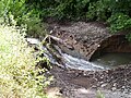
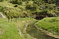
A ponor is a natural opening where surface water enters into underground passages; they may be found in karst landscapes where the geology and the geomorphology is typically dominated by porous limestone rock. Ponors can drain stream or lake water continuously or can at times work as springs, similar to estavelles. [1] Morphologically, ponors come in forms of large pits and caves, large fissures and caverns, networks of smaller cracks, and sedimentary, alluvial drains. [1]

Contents

Etymology

The name for the karst formation ponor comes from Croatian and Slovene. [2] It derives from the proto-Slavic word nora, meaning pit, hole, abyss; the English word narrow probably has the same origin. [3] The noun "ponor" used in contemporary Slovak and Czech has similar meaning - "dive" or "submerging".

Several places in southeast Europe (Bulgaria, Croatia, Czech Republic, Hungary, Romania, Montenegro, Slovenia) bear the name Ponor due to associated karst openings.

Description

Whereas a sinkhole (doline) is a depression of surface topography with a pit or cavity directly underneath, a ponor is kind of a portal where a surface stream or lake flows either partially or completely underground into a karst groundwater system. [1] Steady water erosion may have formed or enlarged the portal in (mainly limestone) rock, in a conglomerate, or in looser materials. Karst terrains are known for surface water losses through small ponors and its resurgence after having traveled through vast underground systems. [1]

Prevalence

Ponors are found worldwide, but only in karst regions. The entire Adriatic watershed within Bosnia and Herzegovina sits on Dinaric karst, with numerous explored and probably many more unexplored ponors and underground flows. [4] [5] There are significant geological ponors in the Carpathian Mountains, the Dinaric Alps, Greece, Turkey, and parts of the southern United States.[ citation needed ]

Dams and reservoirs in karst

Reservoirs in karst are prone to losses due to leakage through ponors. The construction of dams to capture water in karst terrains may pose a great financial risk despite initial investigations and thorough sealing treatments. [6] It wasn't until the twentieth century that the first dams in karst were built, some of which famously failed. [6]

See also

Related Research Articles

<span class="mw-page-title-main">Karst</span> Topography from dissolved soluble rocks

Karst is a topography formed from the dissolution of soluble carbonate rocks such as limestone, dolomite, and gypsum. It is characterized by features like poljes above and drainage systems with sinkholes and caves underground. More weathering-resistant rocks, such as quartzite, can also occur, given the right conditions.

<span class="mw-page-title-main">Sinkhole</span> Geologically-formed topological depression

A sinkhole is a depression or hole in the ground caused by some form of collapse of the surface layer. The term is sometimes used to refer to doline, enclosed depressions that are also known as shakeholes, and to openings where surface water enters into underground passages known as ponor, swallow hole or swallet. A cenote is a type of sinkhole that exposes groundwater underneath. Sink and stream sink are more general terms for sites that drain surface water, possibly by infiltration into sediment or crumbled rock.

<span class="mw-page-title-main">Subterranean river</span> River that runs wholly or partly beneath the ground surface

A subterranean river is a river or watercourse that runs wholly or partly beneath the ground, one where the riverbed does not represent the surface of the Earth. It is distinct from an aquifer, which may flow like a river but is contained within a permeable layer of rock or other unconsolidated materials. A river flowing below ground level in an open gorge is not classed as subterranean.

<span class="mw-page-title-main">Dinaric Alps</span> Mountain range in the Balkan Peninsula of Southeastern Europe

The Dinaric Alps, also Dinarides, are a mountain range in Southern and Southcentral Europe, separating the continental Balkan Peninsula from the Adriatic Sea. They stretch from Italy in the northwest through Slovenia, Croatia, Bosnia and Herzegovina, Serbia, Montenegro, and Kosovo to Albania in the southeast.

<span class="mw-page-title-main">Polje</span> Type of large plain found in karst regions

A polje, also called karst polje or karst field, is a large flat plain found in karstic geological regions of the world, with areas usually in the range of 5–400 km2 (2–154 sq mi). The name derives from the Slavic languages, where polje literally means 'field', whereas in English polje specifically refers to a karst plain or karst field.

<span class="mw-page-title-main">Lake Cerknica</span> Intermittent lake in Slovenia

Lake Cerknica is an intermittent lake in the southern part of the Cerknica Polje, a karst polje in Inner Carniola, a region in southwestern Slovenia. The lake, oriented in the Dinaric direction from northwest to southeast, is present for the most part of the year. When full, it is the largest lake in the country. The plain is surrounded by the Javornik Hills to the south and Slivnica to the north, both belonging to Dinaric Alps. The area of the lake mainly reaches 28 square kilometres (11 sq mi), but can reach up to 38 km2 (15 sq mi) and the surface level varies from 546 m (1,791 ft) to 551 m (1,808 ft) above sea level. The lake is an important wildlife resort, especially as a nesting place for many bird species. Botanically, it is distinguished by amphibious plants. It is therefore a part of two Natura 2000 areas of protection and the focus of the Inner Carniola Regional Park, which covers additional Natura 2000 areas in the broader region. The climate in the area is continental, with a mean temperature of 9.2 °C (48.6 °F) and the annual precipitation about 1,700 millimetres (67 in). The largest settlement at the border of the lake is Cerknica, located north of the lake. Various watersports, including rowing, are popular on the lake.

A losing stream, disappearing stream, influent stream or sinking river is a stream or river that loses water as it flows downstream. The water infiltrates into the ground recharging the local groundwater, because the water table is below the bottom of the stream channel. This is the opposite of a more common gaining stream which increases in water volume farther downstream as it gains water from the local aquifer.

The Trebišnjica is a river in Bosnia and Herzegovina, and the right tributary of the Neretva. Before it was utilized for hydro exploitation via various hydrotechnical interventions and systems with different purposes, Trebišnjica used to be a sinking river, rising and sinking through its course before resurfacing at various places from the Neretva river below the Čapljina to the Adriatic coast, and along the coast from the Neretva Delta to Sutorina.

<span class="mw-page-title-main">Škocjan Caves</span> Cave system in Slovenia

Škocjan Caves is a cave system located in Slovenia. Recognized for its exceptional significance, Škocjan Caves was included on UNESCO’s list of natural and cultural World Heritage Sites in 1986. The international scientific community has acknowledged the caves as one of the planet Earth's natural treasures. Renowned as one of the most important caves in the world, Škocjan Caves is a significant underground phenomenon on the Karst Plateau and in Slovenia. After gaining independence from Yugoslavia in 1991, Slovenia made a commitment to actively protect the Škocjan Caves area. To fulfill this commitment, Škocjan Caves Regional Park was established, along with its managing authority, the Škocjan Caves Park Public Service Agency.

Škocjan Caves Regional Park is located in the Škocjan Karst, a vast flat landscape that lies at an elevation between 420 and 450 m in the southeast part of the Karst area. Following its independence, the Slovenia committed itself to protecting the Škocjan Caves area; for this reason, it established Škocjan Caves Regional Park and its managing authority, the Škocjan Caves Park Public Service Agency.

<span class="mw-page-title-main">Uvala (landform)</span> Toponym for a closed karst depression

Uvala is originally a local toponym used by people in some regions in Slovenia, Croatia, Bosnia and Herzegovina, Montenegro and Serbia. In geosciences it denotes a closed karst depression, a terrain form usually of elongated or compound structure and of larger size than that of sinkholes. It is a morphological form frequently found in the outer Dinaric Alps anywhere between Slovenia and Greece, but large closed karst depressions are found on all continents in different landscapes and therefore uvala has become a globally established term. It is also used to distinguish such depressions from poljes, which are many square kilometres in size. Definitions of uvalas are often poorly empirically supported. "The coalescence of dolines" (sinkholes) is the dominant and most frequently found definition. However, because of the ongoing dissatisfaction with this definition, the term 'uvala' has often been belittled – occasionally it was even proposed that the term be given up altogether.

<span class="mw-page-title-main">Municipality of Mirna Peč</span> Municipality of Slovenia

The Municipality of Mirna Peč is a municipality in southeast Slovenia, located in the traditional region of Lower Carniola. The seat of the municipality, which was established in 1998, is Mirna Peč. With an estimated population of 2,800, the municipality is included in the Southeast Slovenia Statistical Region.

<span class="mw-page-title-main">Trnovo Forest Plateau</span>

The Trnovo Forest Plateau is a karst plateau that constitutes the extreme northwest end of the Dinaric Alps. The Trnovo Forest Plateau has a karst character, without surface watercourses and broken up by closed valleys, outcroppings, hills, caves, shafts, and smaller karst features: solution pans, rills, karrens, and other features. Significant karst features include ice caves. The vegetation inversion at Big Paradana Ice Cave in the eastern part of the plateau, measuring 385 meters (1,263 ft) by 1,550 meters (5,090 ft), is a locus classicus and in the past ice was harvested from it and exported via Gorizia and Trieste to Egypt.

<span class="mw-page-title-main">Lož Karst Field</span>

The Lož Karst Field, also known as the Lož Valley, is a karst field in Inner Carniola in southwest Slovenia. It is the smallest karst field in Inner Carniola.

<span class="mw-page-title-main">Račna Karst Field</span>

The Račna Karst Field is a karst field in the northern edge of the Lower Carniolan karst area, south of Grosuplje, Slovenia. It has rich natural and cultural value. Because of its ecological significance, it is anticipated that a nature park will be established there and that it will be included in the Natura 2000 program.

<span class="mw-page-title-main">Zalomka</span> River in Bosnia and Herzegovina

The Zalomka is a karstic river in the southern part of Bosnia and Herzegovina, and as part of the Neretva river system it is one of the largest sinking rivers in the country and Dinarides. It rises under the Morine plateau, near Brajićevići village in Gacko municipality, but also collects its upper course waters from Gatačko Polje.

Vilina Pećina is a cave and a karst resurgence wellspring in Dinaric Alps karst of Bosnia and Herzegovina, also previously known from research descriptions of older date as "Vilić Pećina", such as one from 1896, conducted by Austria-Hungary geologists.

<span class="mw-page-title-main">Trebišnjica wellsprings group</span> Groupings of springs in Bosnia and Herzegovina

Trebišnjica wellspring-group is a system of two geographically and hydrologically distinct principal groupings of strong karstic springs, Trebišnjica and Čeplica, which together constitute source of the Trebišnjica river. Wellsprings are located just below town of Bileća in Bosnia and Herzegovina. The entire area where founts are situated is submerged under Bilećko Lake since 1967, formed after the construction of Trebinje-1 Hydroelectric Power Station and its large arch dam at Grnčarevo village.

References

  1. 1 2 3 4 Bonacci, Ognjen (2004). "Ponor". In Gunn, John (ed.). Encyclopedia of Caves and Karst Science. Taylor & Francis. pp. 1282–1284. ISBN   978-1-57958-399-6.
  2. Dicken, Samuel N. (November 1935). "Kentucky Karst Landscapes". The Journal of Geology. 43 (7): 708–728. doi:10.1086/624363. JSTOR   30057941. S2CID   140553389. Since local terms such as "sink," "sink hole", "kettle", "bottom", etc., are vague and confusing the Slovene terminology ("ponor", "doline", etc.) is used for the karst forms.
  3. "Ponor/ponirati". Hrvatski jezični portal. Retrieved 2021-11-03.
  4. "The Karstography of the Dinaric Karst in Bosnia and Hercegovina". The Devon Karst Research Society. Retrieved 4 September 2016.
  5. "The Devon Karst Research Society" (.html). www.devonkarst.org.uk. Devon Karst. Retrieved 4 September 2016.
  6. 1 2 Milanović, Petar (2004). "Dams and reservoirs on karst". In Gunn, John (ed.). Encyclopedia of Caves and Karst Science. Taylor & Francis. pp. 571–575. ISBN   978-1-57958-399-6.