
A stalactite is a mineral formation that hangs from the ceiling of caves, hot springs, or man-made structures such as bridges and mines. Any material that is soluble and that can be deposited as a colloid, or is in suspension, or is capable of being melted, may form a stalactite. Stalactites may be composed of lava, minerals, mud, peat, pitch, sand, sinter, and amberat. A stalactite is not necessarily a speleothem, though speleothems are the most common form of stalactite because of the abundance of limestone caves.

Mole Creek Karst is a national park situated in the North of Tasmania, Australia, 168 km northwest of Hobart. It is located on the slopes of the Great Western Tiers to the east of the town of Mole Creek. It is the only national park in Tasmania created specifically to protect karst landforms. It is part of the Tasmanian Wilderness World Heritage Site.
A stalagmite is a type of rock formation that rises from the floor of a cave due to the accumulation of material deposited on the floor from ceiling drippings. Stalagmites are typically composed of calcium carbonate, but may consist of lava, mud, peat, pitch, sand, sinter, and amberat.
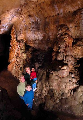
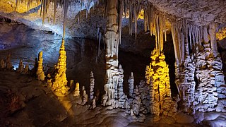
A speleothem is a geological formation by mineral deposits that accumulate over time in natural caves. Speleothems most commonly form in calcareous caves due to carbonate dissolution reactions. They can take a variety of forms, depending on their depositional history and environment. Their chemical composition, gradual growth, and preservation in caves make them useful paleoclimatic proxies.

A soda straw is a speleothem in the form of a hollow mineral cylindrical tube. They are also known as tubular stalactites. Soda straws grow in places where water leaches slowly through cracks in rock, such as on the roofs of caves. Soda straws in caves rarely grow more than a few millimetres per year and may average one tenth of a millimetre per year. A soda straw can turn into a stalactite if the hole at the bottom is blocked, or if the water begins flowing on the outside surface of the hollow tube. Soda straws can also form outside the cave environment on exposed concrete surfaces as a type of calthemite, growing significantly faster than those formed on rock.

A lava tube, or pyroduct, is a natural conduit formed by flowing lava from a volcanic vent that moves beneath the hardened surface of a lava flow. If lava in the tube empties, it will leave a cave.

Luray Caverns, originally called Luray Cave, is a cave just west of Luray, Virginia, United States, which has drawn many visitors since its discovery in 1878. The cavern system is generously adorned with speleothems such as columns, mud flows, stalactites, stalagmites, flowstone, and mirrored pools. The caverns are perhaps best known for the Great Stalacpipe Organ, a lithophone made from solenoid-fired strikers that tap stalactites of various sizes to produce tones similar to those of xylophones, tuning forks, or bells.

Flowstones are sheetlike deposits of calcite or other carbonate minerals, formed where water flows down the walls or along the floors of a cave. They are typically found in "solution caves", in limestone, where they are the most common speleothem. However, they may form in any type of cave where water enters that has picked up dissolved minerals. Flowstones are formed via the degassing of vadose percolation waters.
Cave of the Mounds, a natural limestone cave located near Blue Mounds, Wisconsin, United States, is named for two nearby hills called the Blue Mounds. It is located in the southern slope of the east hill. The cave's beauty comes from its many varieties of mineral formations called speleothems. The Chicago Academy of Sciences considers the Cave of the Mounds to be "the significant cave of the upper Midwest" because of its beauty, and it is promoted as the "jewel box" of major American caves. In 1987, the United States Department of the Interior and the National Park Service designated the cave as a National Natural Landmark.

Anthodites (Greek ἄνθος ánthos, "flower", -ode, adjectival combining form, -ite adjectival suffix) are speleothems (cave formations) composed of long needle-like crystals situated in clusters which radiate outward from a common base. The "needles" may be quill-like or feathery. Most anthodites are made of the mineral aragonite (a variety of calcium carbonate, CaCO3), although some are composed of gypsum (CaSO4·2H2O).

The Borra Caves(Borrā Guhalu) are located on the East Coast of India, in the Ananthagiri hills of the Araku Valley of the Alluri Sitharama Raju district in Andhra Pradesh. The caves, one of the largest in the country, at an elevation of about 705 m (2,313 ft), distinctly exhibit a variety of speleothems ranging in size and irregularly shaped stalactites and stalagmites. The caves are basically karstic limestone structures extending to a depth of 80 m (260 ft), and are considered the deepest caves in India. The native name for the caves is Borrā Guhalu where Borra means abdomen in and Guhalu means caves in Telugu language.
Avshalom Cave, known in academic literature as Soreq Cave, Arabic: مغارة سوريك, romanized: Mghar Suriq) an popularly as Stalactites Cave, is a 5,000 m2 cave on the western side of Mt. Ye'ela, in the Judean hills in Israel, unique for its dense concentration of stalactites and other cave formations.

Rimstone, also called gours, is a type of speleothem in the form of a stone dam. Rimstone is made up of calcite and other minerals that build up in cave pools. The formation created, which looks like stairs, often extends into flowstone above or below the original rimstone. Often, rimstone is covered with small, micro-gours on horizontal surfaces. Rimstone basins may form terraces that extend over hundreds of feet, with single basins known up to 200 feet long from Tham Xe Biang Fai in Laos.

Abukuma-do is a limestone cave located in Fukushima Prefecture, Japan. The cave was discovered on August 15, 1969, northeast of the city of Tamura and was originally named Kamayama Shonyu-do (釜山鍾乳洞). It was designated a natural heritage of the town on February 7, 1971, and renamed Abukuma-do on June 1, 1973. Visitors can traverse a 600-metre-long path inside the cave as well as a 120-metre-long exploration course to view the stalactites and stalagmites. Each stalactite has taken more than eighty million years to form. Beyond the public areas lie about 2,500 metres of cave that are not open to the public. Nearby Abukuma Cave is the smaller Irimizu Shonyu-do, discovered in 1927. Irimizu Limestone Cave was designated a National Natural Treasure on December 28, 1934. The temperature inside Abukuma-do is approximately 15 °C and the humidity is above 90%.

The Belum Caves, located in Nandyala district of Andhra Pradesh's Rayalaseema region, is the second largest cave system on the Indian subcontinent, known for its speleothems, such as stalactite and stalagmite formations. The Belum Caves have long passages, galleries, spacious caverns with fresh water and siphons. This cave system was formed over the course of tens of thousands of years by the constant flow of underground water from the now-disappeared river Chitravathi. The cave system reaches its deepest point at the point known as Pataalaganga. Belum Caves have a length of 3,229 m (10,593.8 ft), making them the second largest caves on the Indian Subcontinent after the Krem Liat Prah caves in Meghalaya. It is one of the centrally protected Monuments of National Importance.

El Soplao is a cave located in the municipalities of Rionansa, Valdáliga and Herrerías in Cantabria, Spain. It is considered unique for the quality and quantity of geological formations (speleothems) in its 17 miles length, 6 of which are open to the public. In it are formations such as helictites and curtains. Its formation dates back to the Mesozoic, in particular the Cretaceous period 240 million years ago. The entrance is at 540 metres in the Sierra Soplao Arnero.

The Villars Cave, in French Grotte de Villars or Grotte du Cluzeau, was occupied during the Lower Magdalenian by Cro-Magnon hunter-gatherers. The cave is part of the French commune of Villars in the northern Dordogne département. Besides its enormous wealth in beautiful stalactites, stalagmites and similar calcite deposits it contains cave paintings and some engravings. The Villars Cave and the Rouffignac Cave are the biggest known cave systems in the Dordogne.
Calcite crystals form on the surface of quiescent bodies of water, even when the bulk water is not supersaturated with respect to calcium carbonate. The crystals grow, attach to one other and appear to be floating rafts of a white, opaque material. The floating materials have been referred to as calcite rafts or "leopard spots".

The Cliefden Caves is a heritage-listed geoheritage site in Mandurama, Cowra Shire, New South Wales, Australia. The caves comprise Ordovician fossil localities, limestone caves, a spring and tufa dams, and a site where limestone was first discovered in inland Australia.

Calthemite is a secondary deposit, derived from concrete, lime, mortar or other calcareous material outside the cave environment. Calthemites grow on or under, man-made structures and mimic the shapes and forms of cave speleothems, such as stalactites, stalagmites, flowstone etc. Calthemite is derived from the Latin calx "lime" + Latin < Greek théma, "deposit" meaning ‘something laid down’, and the Latin –ita < Greek -itēs – used as a suffix indicating a mineral or rock. The term "speleothem", due to its definition can only be used to describe secondary deposits in caves and does not include secondary deposits outside the cave environment.

