Sedimentology encompasses the study of modern sediments such as sand, silt, and clay, and the processes that result in their formation, transport, deposition and diagenesis. Sedimentologists apply their understanding of modern processes to interpret geologic history through observations of sedimentary rocks and sedimentary structures.

Soil liquefaction occurs when a cohesionless saturated or partially saturated soil substantially loses strength and stiffness in response to an applied stress such as shaking during an earthquake or other sudden change in stress condition, in which material that is ordinarily a solid behaves like a liquid. In soil mechanics, the term "liquefied" was first used by Allen Hazen in reference to the 1918 failure of the Calaveras Dam in California. He described the mechanism of flow liquefaction of the embankment dam as:
If the pressure of the water in the pores is great enough to carry all the load, it will have the effect of holding the particles apart and of producing a condition that is practically equivalent to that of quicksand… the initial movement of some part of the material might result in accumulating pressure, first on one point, and then on another, successively, as the early points of concentration were liquefied.

A turbidite is the geologic deposit of a turbidity current, which is a type of amalgamation of fluidal and sediment gravity flow responsible for distributing vast amounts of clastic sediment into the deep ocean.
A turbidity current is most typically an underwater current of usually rapidly moving, sediment-laden water moving down a slope; although current research (2018) indicates that water-saturated sediment may be the primary actor in the process. Turbidity currents can also occur in other fluids besides water.
Paleoliquefaction is any liquefaction features attributed to seismic events occurring before measurements or written records were kept of earthquakes. The study of these features can reveal a great deal about the seismicity of regions where large earthquakes happen infrequently. This is a subset of the broader field of paleoseismology.
Trace fossils are classified in various ways for different purposes. Traces can be classified taxonomically, ethologically, and toponomically, that is, according to their relationship to the surrounding sedimentary layers. Except in the rare cases where the original maker of a trace fossil can be identified with confidence, phylogenetic classification of trace fossils is an unreasonable proposition.

A clastic dike is a seam of sedimentary material that fills an open fracture in and cuts across sedimentary rock strata or layering in other rock types. Clastic dikes form rapidly by fluidized injection or passively by water, wind, and gravity. Diagenesis may play a role in the formation of some dikes. Clastic dikes are commonly vertical or near-vertical. Centimeter-scale widths are common, but thicknesses range from millimetres to metres. Length is usually many times width.

Sedimentary structures include all kinds of features in sediments and sedimentary rocks, formed at the time of deposition.
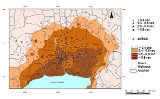
Seismic microzonation is defined as the process of subdividing a potential seismic or earthquake prone area into zones with respect to some geological and geophysical characteristics of the sites such as ground shaking, liquefaction susceptibility, landslide and rock fall hazard, earthquake-related flooding, so that seismic hazards at different locations within the area can correctly be identified. Microzonation provides the basis for site-specific risk analysis, which can assist in the mitigation of earthquake damage. In most general terms, seismic microzonation is the process of estimating the response of soil layers under earthquake excitations and thus the variation of earthquake characteristics on the ground surface.
Seismotectonics is the study of the relationship between the earthquakes, active tectonics and individual faults of a region. It seeks to understand which faults are responsible for seismic activity in an area by analysing a combination of regional tectonics, recent instrumentally recorded events, accounts of historical earthquakes and geomorphological evidence. This information can then be used to quantify the seismic hazard of an area.

The 1975 Kinnaur earthquake occurred in the early afternoon of 19 January. It had a magnitude of 6.8 on the surface wave magnitude scale and a maximum perceived intensity of IX (Violent) on the Mercalli intensity scale, causing extensive damage in Himachal Pradesh, in northern India. Its epicentre was in Kinnaur district in the southeastern part of Himachal Pradesh and caused 47 casualties. Landslides, rock falls and avalanches caused major damage to the Hindustan-Tibet Road. The earthquake affected many monasteries and buildings in the state and led to an extensive restoration work in the late 1970s and early 1980s in Himachal Pradesh. The Spiti and Parachu valleys in particular suffered the greatest damage being on the north–south Kaurik-Chango fault, causing damage to landmarks such as Key Monastery and Tabo Monastery.

Microbially induced sedimentary structures (MISS) are primary sedimentary structures formed by the interaction of microbes with sediment and physical agents of erosion, deposition, and transportation. The structures commonly form when microbial mats are preserved in the sedimentary geological record. There are 17 main types of macroscopic and microscopic MISS. Of those, wrinkle structures and microbial mat chips are the most abundant in the fossil record. Other MISS include sinoidal structures, polygonal oscillation cracks, multidirected ripple marks, erosional remnants and pockets, or gas domes.

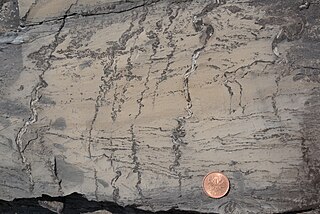
A flame structure is a type of soft-sediment deformation that forms in unconsolidated sediments. The weight of an overlying bed forces an underlying bed to push up through the overlying bed, generally when both strata are saturated with water. The resulting pattern may resemble flames. In order for the flame structure to occur, the overlying bed must be of a higher density than the underlying bed, or there must be differential pressures in the upper bed.
Load casts are bulges, lumps, and lobes that can form on the bedding planes that separate the layers of sedimentary rocks. The lumps "hang down" from the upper layer into the lower layer, and typically form with fairly equal spacing. These features form during soft-sediment deformation shortly after sediment burial, before the sediments lithify. They can be created when a denser layer of sediment is deposited on top of a less-dense sediment. This arrangement is gravitationally unstable, which encourages formation of a Rayleigh-Taylor instability if the sediment becomes liquefied. Once the sediments can flow, the instability creates the "hanging" lobes and knobs of the load casts as plumes of the denser sediment descend into the less-dense layer.
A dish structure is a type of sedimentary structure formed by liquefaction and fluidization of water-charged soft sediment either during or immediately following deposition. Dish structures are most commonly found in turbidites and other types of clastic deposits that result from subaqueous sediment gravity flows.

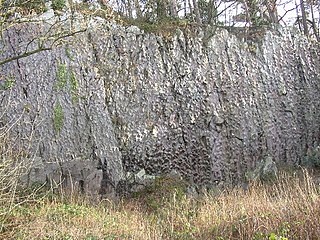
Ball-and-pillow structures are masses of clastic sediment that take the form of isolated pillows or protruding ball structures. These soft-sediment deformations are usually found at the base of sandstone beds that are interbedded with mudstone. It is also possible to find ball-and-pillows in limestone beds that overlie shale, but it's less common. They are normally hemispherical or kidney shaped, and range in size from a few inches to several feet.

Soft-sediment deformation structures develop at deposition or shortly after, during the first stages of the sediment's consolidation. This is because the sediments need to be "liquid-like" or unsolidified for the deformation to occur. These formations have also been put into a category called water-escape structures by Lowe (1975). The most common places for soft-sediment deformations to materialize are in deep water basins with turbidity currents, rivers, deltas, and shallow-marine areas with storm impacted conditions. This is because these environments have high deposition rates, which allows the sediments to pack loosely.
Seismic site effects are related to the amplification of seismic waves in superficial geological layers. The surface ground motion may be strongly amplified if the geological conditions are unfavorable. Therefore, the study of local site effects is an important part of the assessment of strong ground motions, seismic hazard and engineering seismology in general. Damage due to an earthquake may thus be aggravated as in the case of the 1985 Mexico City earthquake. For alluvial basins, we may shake a bowl of jelly to model the phenomenon at a small scale.
Molar tooth structures are ribbon-like veins and nodules of calcite that are found widespread in Precambrian carbonate sedimentary rocks between approximately 2600 to 570 million years ago. Their mechanism for formation remains debated, with hypothesis including the generation of methane gas within sediments, pumping of water through sediment by wave action, tsunamis, and bacterial processes.

Teepee structures are sedimentary structures interpreted to represent formation in peritidal environments. Teepees are largely the result of evaporation of water and subsequent precipitation of minerals within sediment, resulting in expansion and buckling to form a teepee-like shape. Their name originates from geologists working in the Guadalupe Mountains, who noted their appearance in cross-section resembles that of a Native American teepee.


