Submarine earthquake

Last updated
Submarine earthquake often cause tsunami Eq-gen3.svg
Submarine earthquake often cause tsunami

A submarine, undersea, or underwater earthquake is an earthquake that occurs underwater at the bottom of a body of water, especially an ocean. They are the leading cause of tsunamis. The magnitude can be measured scientifically by the use of the moment magnitude scale and the intensity can be assigned using the Mercalli intensity scale.

Contents

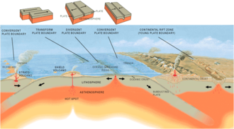
Understanding plate tectonics helps to explain the cause of submarine earthquakes. The Earth's surface or lithosphere comprises tectonic plates which average approximately 50 miles in thickness, and are continuously moving very slowly upon a bed of magma in the asthenosphere and inner mantle. The plates converge upon one another, and one subducts below the other, or, where there is only shear stress, move horizontally past each other (see transform plate boundary below). Little movements called fault creep are minor and not measurable. The plates meet with each other, and if rough spots cause the movement to stop at the edges, the motion of the plates continue. When the rough spots can no longer hold, the sudden release of the built-up motion releases, and the sudden movement under the sea floor causes a submarine earthquake. This area of slippage both horizontally and vertically is called the epicenter, and has the highest magnitude, and causes the greatest damage.

As with a continental earthquake the severity of the damage is not often caused by the earthquake at the rift zone, but rather by events which are triggered by the earthquake. Where a continental earthquake will cause damage and loss of life on land from fires, damaged structures, and flying objects; a submarine earthquake alters the seabed, resulting in a series of waves, and depending on the length and magnitude of the earthquake, tsunami, which bear down on coastal cities causing property damage and loss of life.

Submarine earthquakes can also damage submarine communications cables, leading to widespread disruption of the Internet and international telephone network in those areas. This is particularly common in Asia, where many submarine links cross submarine earthquake zones along Pacific Ring of Fire.

Tectonic plate boundaries

Tectonic plate boundaries, showing the directions of plate movements. Plates tect2 en.svg
Tectonic plate boundaries, showing the directions of plate movements.
Different kinds of boundaries Tectonic plate boundaries.png
Different kinds of boundaries

The different ways in which tectonic plates rub against each other under the ocean or sea floor to create submarine earthquakes. The type of friction created may be due to the characteristic of the geologic fault or the plate boundary as follows. Some of the main areas of large tsunami producing submarine earthquakes are the Pacific Ring of Fire and the Great Sumatran fault.

Convergent plate boundary

The older, and denser plate moves below the lighter plate. The further down it moves, the hotter it becomes, until finally melting altogether at the asthenosphere and inner mantle and the crust is actually destroyed. The location where the two oceanic plates actually meet become deeper and deeper creating trenches with each successive action. There is an interplay of various densities of lithosphere rock, asthenosphere magma, cooling ocean water and plate movement for example the Pacific Ring of Fire. Therefore, the site of the sub oceanic trench will be a site of submarine earthquakes; for example the Mariana Trench, Puerto Rico Trench, and the volcanic arc along the Great Sumatran fault. [1]

Transform plate boundary

A transform-fault boundary, or simply a transform boundary is where two plates will slide past each other, and the irregular pattern of their edges may catch on each other. The lithosphere is neither added to from the asthenosphere nor is it destroyed as in convergent plate action. For example, along the San Andreas fault strike-slip fault zone, the Pacific Tectonic Plate has been moving along at about 5 cm/yr in a northwesterly direction, whereas the North American Plate is moving south-easterly. [2]

Divergent plate boundary

Rising convection currents occur where two plates are moving away from each other. In the gap, thus produced hot magma rises up, meets the cooler sea water, cools, and solidifies, attaching to either or both tectonic plate edges creating an oceanic spreading ridge. When the fissure again appears, again magma will rise up, and form new lithosphere crust. If the weakness between the two plates allows the heat and pressure of the asthenosphere to build over a large amount of time, a large quantity of magma will be released pushing up on the plate edges and the magma will solidify under the newly raised plate edges, see formation of a submarine volcano. If the fissure is able to come apart because of the two plates moving apart, in a sudden movement, an earthquake tremor may be felt for example at the Mid-Atlantic Ridge between North America and Africa. [3]

List of major submarine earthquakes

The following is a list of some major submarine earthquakes since the 17th century.

DateEventLocationEstimated moment magnitude (Mw )Notes
March 11, 2011 2011 Tōhoku earthquake The epicenter is 130 kilometers (81 mi) off the east coast of the Oshika Peninsula, Tōhoku, with the hypocenter at a depth of 32 km (20 mi).9.1This is the largest known earthquake to hit Japan
December 26, 2006 2006 Hengchun earthquakes The epicenter is off the southwest coast of Taiwan, in the Luzon Strait, which connects the South China Sea with the Philippine Sea.7.1
December 26, 2004 2004 Indian Ocean earthquake The epicenter is off the northwestern coast of Sumatra, Indonesia.9.2This is the third largest earthquake in recorded history and generated massive tsunamis, which caused widespread devastation when they hit land, leaving an estimated 230,000 people dead in countries around the Bay of Bengal and the Indian Ocean.
May 4, 1998A part of the island of Yonaguni was destroyed by a submarine earthquake.
May 22, 1960 1960 Valdivia earthquake (Great Chilean Earthquake)The epicenter is off the coast of South Central Chile.9.5This is the largest earthquake ever recorded.
December 20, 1946 1946 Nankai earthquake The epicenter is off the southern coast of Kii Peninsula and Shikoku, Japan.8.1
December 7, 1944 1944 Tōnankai earthquake The epicenter is about 20 km off the coast of the Shima Peninsula in Japan.8.0
November 18, 1929 1929 Grand Banks earthquake The epicenter is at Grand Banks, off the south coast of Newfoundland in the Atlantic Ocean.7.2
June 15, 1896 1896 Sanriku earthquake The epicenter is off the Sanriku coast of northeastern Honshū, Japan.8.5
April 4, 1771The epicenter is near Yaeyama Islands in Okinawa, Japan.7.4
January 26, 1700 1700 Cascadia earthquake The epicenter is offshore from Vancouver Island to northern California.9.0This is one of the largest earthquakes on record.

Storm-caused earthquakes

A 2019 study based on new higher-resolution data from the Transportable Array network of USArray found that large ocean storms could create undersea earthquakes when they passed over certain areas of the ocean floor, including Georges Bank near Cape Cod and the Grand Banks of Newfoundland. [4] They have also been observed in the Pacific Northwest. [5]

See also

Related Research Articles

<span class="mw-page-title-main">Plate tectonics</span> Movement of Earths lithosphere

Plate tectonics is the scientific theory that Earth's lithosphere comprises a number of large tectonic plates, which have been slowly moving since about 3.4 billion years ago. The model builds on the concept of continental drift, an idea developed during the first decades of the 20th century. Plate tectonics came to be accepted by geoscientists after seafloor spreading was validated in the mid-to-late 1960s.

<span class="mw-page-title-main">Subduction</span> A geological process at convergent tectonic plate boundaries where one plate moves under the other

Subduction is a geological process in which the oceanic lithosphere and some continental lithosphere is recycled into the Earth's mantle at convergent boundaries. Where the oceanic lithosphere of a tectonic plate converges with the less dense lithosphere of a second plate, the heavier plate dives beneath the second plate and sinks into the mantle. A region where this process occurs is known as a subduction zone, and its surface expression is known as an arc-trench complex. The process of subduction has created most of the Earth's continental crust. Rates of subduction are typically measured in centimeters per year, with rates of convergence as high as 11 cm/year.

<span class="mw-page-title-main">Transform fault</span> Plate boundary where the motion is predominantly horizontal

A transform fault or transform boundary, is a fault along a plate boundary where the motion is predominantly horizontal. It ends abruptly where it connects to another plate boundary, either another transform, a spreading ridge, or a subduction zone. A transform fault is a special case of a strike-slip fault that also forms a plate boundary.

<span class="mw-page-title-main">Divergent boundary</span> Linear feature that exists between two tectonic plates that are moving away from each other

In plate tectonics, a divergent boundary or divergent plate boundary is a linear feature that exists between two tectonic plates that are moving away from each other. Divergent boundaries within continents initially produce rifts, which eventually become rift valleys. Most active divergent plate boundaries occur between oceanic plates and exist as mid-oceanic ridges.

<span class="mw-page-title-main">Convergent boundary</span> Region of active deformation between colliding tectonic plates

A convergent boundary is an area on Earth where two or more lithospheric plates collide. One plate eventually slides beneath the other, a process known as subduction. The subduction zone can be defined by a plane where many earthquakes occur, called the Wadati–Benioff zone. These collisions happen on scales of millions to tens of millions of years and can lead to volcanism, earthquakes, orogenesis, destruction of lithosphere, and deformation. Convergent boundaries occur between oceanic-oceanic lithosphere, oceanic-continental lithosphere, and continental-continental lithosphere. The geologic features related to convergent boundaries vary depending on crust types.

<span class="mw-page-title-main">Tectonics</span> Process of evolution of the earths crust

Tectonics are the processes that result in the structure and properties of the Earth's crust and its evolution through time.

<span class="mw-page-title-main">Japan Trench</span> Oceanic trench part of the Pacific Ring of Fire off northeast Japan

The Japan Trench is an oceanic trench part of the Pacific Ring of Fire off northeast Japan. It extends from the Kuril Islands to the northern end of the Izu Islands, and is 8,046 metres (26,398 ft) at its deepest. It links the Kuril–Kamchatka Trench to the north and the Izu–Ogasawara Trench to its south with a length of 800 kilometres (497 mi). This trench is created as the oceanic Pacific plate subducts beneath the continental Okhotsk Plate. The subduction process causes bending of the down going plate, creating a deep trench. Continuing movement on the subduction zone associated with the Japan Trench is one of the main causes of tsunamis and earthquakes in northern Japan, including the megathrust Tōhoku earthquake and resulting tsunami that occurred on 11 March 2011. The rate of subduction associated with the Japan Trench has been recorded at about 7.9–9.2 centimetres (3.1–3.6 in)/yr.

<span class="mw-page-title-main">Island arc</span> Arc-shaped archipelago formed by intense seismic activity of long chains of active volcanoes

Island arcs are long chains of active volcanoes with intense seismic activity found along convergent tectonic plate boundaries. Most island arcs originate on oceanic crust and have resulted from the descent of the lithosphere into the mantle along the subduction zone. They are the principal way by which continental growth is achieved.

<span class="mw-page-title-main">Juan de Fuca Plate</span> Small tectonic plate in the eastern North Pacific

The Juan de Fuca Plate is a small tectonic plate (microplate) generated from the Juan de Fuca Ridge that is subducting beneath the northerly portion of the western side of the North American Plate at the Cascadia subduction zone. It is named after the explorer of the same name. One of the smallest of Earth's tectonic plates, the Juan de Fuca Plate is a remnant part of the once-vast Farallon Plate, which is now largely subducted underneath the North American Plate.

Megathrust earthquakes occur at convergent plate boundaries, where one tectonic plate is forced underneath another. The earthquakes are caused by slip along the thrust fault that forms the contact between the two plates. These interplate earthquakes are the planet's most powerful, with moment magnitudes (Mw) that can exceed 9.0. Since 1900, all earthquakes of magnitude 9.0 or greater have been megathrust earthquakes.

In tectonics, vertical displacement refers to the shifting of land in a vertical direction, resulting in uplift and subsidence. The displacement of rock layers can provide information on how and why Earth's lithosphere changes throughout geologic time. There are different mechanisms which lead to vertical displacement such as tectonic activity, and isostatic adjustments. Tectonic activity leads to vertical displacement when crust is rearranged during a seismic event. Isostatic adjustments result in vertical displacement through sinking due to an increased load or isostatic rebound due to load removal.

The Sunda Trench, earlier known as and sometimes still indicated as the Java Trench, is an oceanic trench located in the Indian Ocean near Sumatra, formed where the Australian-Capricorn plates subduct under a part of the Eurasian Plate. It is 3,200 kilometres (2,000 mi) long with a maximum depth of 7,290 metres. Its maximum depth is the deepest point in the Indian Ocean. The trench stretches from the Lesser Sunda Islands past Java, around the southern coast of Sumatra on to the Andaman Islands, and forms the boundary between Indo-Australian Plate and Eurasian plate. The trench is considered to be part of the Pacific Ring of Fire as well as one of a ring of oceanic trenches around the northern edges of the Australian Plate.

<span class="mw-page-title-main">Aleutian Trench</span> An oceanic trench along the southern coastline of Alaska and the Aleutian islands

The Aleutian Trench is an oceanic trench along a convergent plate boundary which runs along the southern coastline of Alaska and the Aleutian islands. The trench extends for 3,400 kilometres (2,100 mi) from a triple junction in the west with the Ulakhan Fault and the northern end of the Kuril–Kamchatka Trench, to a junction with the northern end of the Queen Charlotte Fault system in the east. It is classified as a "marginal trench" in the east as it runs along the margin of the continent. The subduction along the trench gives rise to the Aleutian Arc, a volcanic island arc, where it runs through the open sea west of the Alaska Peninsula. As a convergent plate boundary, the trench forms part of the boundary between two tectonic plates. Here, the Pacific Plate is being subducted under the North American Plate at a dip angle of nearly 45°. The rate of closure is 7.5 centimetres (3 in) per year.

<span class="mw-page-title-main">Great Sumatran fault</span> Geological feature

The Indonesian island of Sumatra is located in a highly seismic area of the world. In addition to the subduction zone off the west coast of the island, Sumatra also has a large strike-slip fault, the Great Sumatran Fault also known as Semangko Fault, running the entire length of the island. This fault zone accommodates most of the strike-slip motion associated with the oblique convergence between the Indo-Australian and Eurasian plates. The fault ends in the north just below the city of Banda Aceh, which was devastated in the 2004 Indian Ocean earthquake. After the December 2004 earthquake, pressure on the Great Sumatran Fault has increased tremendously, especially in the north.

This is a list of articles related to plate tectonics and tectonic plates.

The 2000 New Ireland earthquakes occurred off the coast of New Ireland Province, Papua New Guinea on November 16 and 17.

Shortly after midnight local time on January 20, 1981, eastern Indonesia was struck by an earthquake known as the 1981 Irian Jaya earthquake. Registering a moment magnitude of 6.7, it killed more than 300 people, damaging structures and buildings across the Irian Jaya province. Indonesia is highly active in terms of seismicity and volcanic eruptions, with a subduction zone and many faults. It is neighbored by several tectonic plates. Such earthquakes pose a significant threat to life in the area through earthquakes and also tsunamis.

This is a list of different types of earthquake.

Ridge push is a proposed driving force for plate motion in plate tectonics that occurs at mid-ocean ridges as the result of the rigid lithosphere sliding down the hot, raised asthenosphere below mid-ocean ridges. Although it is called ridge push, the term is somewhat misleading; it is actually a body force that acts throughout an ocean plate, not just at the ridge, as a result of gravitational pull. The name comes from earlier models of plate tectonics in which ridge push was primarily ascribed to upwelling magma at mid-ocean ridges pushing or wedging the plates apart.

Magmatism along strike-slip faults is the process of rock melting, magma ascent and emplacement, associated with the tectonics and geometry of various strike-slip settings, most commonly occurring along transform boundaries at mid-ocean ridge spreading centres and at strike-slip systems parallel to oblique subduction zones. Strike-slip faults have a direct effect on magmatism. They can either induce magmatism, act as a conduit to magmatism and magmatic flow, or block magmatic flow. In contrast, magmatism can also directly impact on strike-slip faults by determining fault formation, propagation and slip. Both magma and strike-slip faults coexist and affect one another.

References

  1. Convergent Plate Boundaries - Convergent Boundary - Geology.com Archived 2007-05-01 at the Wayback Machine URL accessed January 23, 2007
  2. Understanding plate motions [This Dynamic Earth, USGS, Archived 2019-05-16 at the Wayback Machine , URL accessed January 23, 2007
  3. Divergent Plate Boundaries - Divergent Boundary - Geology.com Archived 2007-05-01 at the Wayback Machine URL accessed January 23, 2007
  4. "Stormquakes! They're real — and happening off New England". The Boston Globe . Archived from the original on 2019-10-28. Retrieved 2019-10-27.
  5. "Short Wave - Discovering 'Stormquakes'". NPR.org. 2020-01-29. Archived from the original on 2021-04-19. Retrieved 2021-04-15.