Mid-Atlantic Ridge

Last updated
A bathymetric map of the Mid-Atlantic Ridge (shown in light blue in the middle of the Atlantic Ocean) Atlantic bathymetry.jpg
A bathymetric map of the Mid-Atlantic Ridge (shown in light blue in the middle of the Atlantic Ocean)

The Mid-Atlantic Ridge is a mid-ocean ridge (a divergent or constructive plate boundary) located along the floor of the Atlantic Ocean, and part of the longest mountain range in the world. In the North Atlantic, the ridge separates the North American from the Eurasian Plate and the African Plate, north and south of the Azores Triple Junction. In the South Atlantic, it separates the African and South American plates. The ridge extends from a junction with the Gakkel Ridge (Mid-Arctic Ridge) northeast of Greenland southward to the Bouvet Triple Junction in the South Atlantic. Although the Mid-Atlantic Ridge is mostly an underwater feature, portions of it have enough elevation to extend above sea level, for example in Iceland. The ridge has an average spreading rate of about 2.5 centimetres (1 in) per year. [1]

Contents

Discovery

Pangaea's separation (animated) Pangea animation 03.gif
Pangaea's separation (animated)

A ridge under the northern Atlantic Ocean was first inferred by Matthew Fontaine Maury in 1853, based on soundings by the USS Dolphin. The existence of the ridge and its extension into the South Atlantic was confirmed during the expedition of HMS Challenger in 1872. [2] [3] A team of scientists on board, led by Charles Wyville Thomson, discovered a large rise in the middle of the Atlantic while investigating the future location for a transatlantic telegraph cable. [4] The existence of such a ridge was confirmed by sonar in 1925 [5] and was found to extend around Cape Agulhas into the Indian Ocean by the German Meteor expedition. [6]

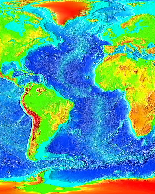
In the 1950s, mapping of the Earth's ocean floors by Marie Tharp, Bruce Heezen, Maurice Ewing, and others revealed that the Mid-Atlantic Ridge had a strange bathymetry of valleys and ridges, [7] with its central valley being seismologically active and the epicenter of many earthquakes. [8] [9] Ewing, Heezen and Tharp discovered that the ridge is part of a 40,000-km (25,000 mile) long essentially continuous system of mid-ocean ridges on the floors of all the Earth's oceans. [10] The discovery of this worldwide ridge system led to the theory of seafloor spreading and general acceptance of Alfred Wegener's theory of continental drift and expansion in the modified form of plate tectonics. The ridge is central to the breakup of the hypothetical supercontinent of Pangaea that began some 180 million years ago.

Notable features

Iceland Mid-Atlantic Ridge map.svg
Iceland mid atlantic ridge.JPG
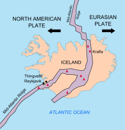
In Iceland the Mid-Atlantic Ridge passes across the Þingvellir National Park, a popular destination for tourists

The Mid-Atlantic Ridge includes a deep rift valley that runs along the axis of the ridge for nearly its entire length. This rift marks the actual boundary between adjacent tectonic plates, where magma from the mantle reaches the seafloor, erupting as lava and producing new crustal material for the plates.

Near the equator, the Mid-Atlantic Ridge is divided into the North Atlantic Ridge and the South Atlantic Ridge by the Romanche Trench, a narrow submarine trench with a maximum depth of 7,758 m (25,453 ft), one of the deepest locations of the Atlantic Ocean. This trench, however, is not regarded as the boundary between the North and South American Plates, nor the Eurasian and African Plates.

Islands

Mid-Atlantic Ridge
Approximate surface projection on Atlantic Ocean of Mid-Atlantic Ridge (purple). Associated fracture zones (orange) are also shown. Click to expand map to obtain interactive details.'"`UNIQ--ref-00000016-QINU`"'

The islands on or near the Mid-Atlantic Ridge, from north to south, with their respective highest peaks and location, are:

Northern Hemisphere (North Atlantic Ridge):

  1. Jan Mayen (Beerenberg, 2277 metres (7470') (at 71°06′N08°12′W / 71.100°N 8.200°W / 71.100; -8.200 ), in the Arctic Ocean
  2. Iceland (Hvannadalshnúkur at Vatnajökull, 2109.6 metres (6921') (at 64°01′N16°41′W / 64.017°N 16.683°W / 64.017; -16.683 ), through which the ridge runs
  3. Azores (Ponta do Pico or Pico Alto, on Pico Island, 2351 metres (7713'), (at 38°28′0″N28°24′0″W / 38.46667°N 28.40000°W / 38.46667; -28.40000 )
  4. Saint Peter and Paul Rocks (Southwest Rock, 22.5 metres (74'), at 00°55′08″N29°20′35″W / 0.91889°N 29.34306°W / 0.91889; -29.34306 )

Southern Hemisphere (South Atlantic Ridge):

  1. Ascension Island (The Peak, Green Mountain, 859 metres (2818'), at 07°59′S14°25′W / 7.983°S 14.417°W / -7.983; -14.417 )
  2. Saint Helena (Diana's Peak, 818 metres (2684') at 15°57′S5°41′W / 15.950°S 5.683°W / -15.950; -5.683 )
  3. Tristan da Cunha (Queen Mary's Peak, 2062 metres (6765'), at 37°05′S12°17′W / 37.083°S 12.283°W / -37.083; -12.283 )
  4. Gough Island (Edinburgh Peak, 909 metres (2982'), at 40°20′S10°00′W / 40.333°S 10.000°W / -40.333; -10.000 )
  5. Bouvet Island (Olavtoppen, 780 metres (2560'), at 54°24′S03°21′E / 54.400°S 3.350°E / -54.400; 3.350 )

Iceland

The submarine section of the Mid-Atlantic Ridge close to southwest Iceland is known as the Reykjanes Ridge. The Mid-Atlantic Ridge runs through Iceland where the ridge is also known as the Neovolcanic Zone. In northern Iceland the Tjörnes Fracture Zone connects Iceland to the Kolbeinsey Ridge.

Geology

Basaltic rocks of the Mid-Atlantic Ridge observed by the Hercules ROV during the 2005 Lost City Expedition Expl2286 - Flickr - NOAA Photo Library.jpg
Basaltic rocks of the Mid-Atlantic Ridge observed by the Hercules ROV during the 2005 Lost City Expedition

The ridge sits atop a geologic feature known as the Mid-Atlantic Rise, which is a progressive bulge that runs the length of the Atlantic Ocean, with the ridge resting on the highest point of this linear bulge. This bulge is thought to be caused by upward convective forces in the asthenosphere pushing the oceanic crust and lithosphere. This divergent boundary first formed in the Triassic period, when a series of three-armed grabens coalesced on the supercontinent Pangaea to form the ridge. Usually, only two arms of any given three-armed graben become part of a divergent plate boundary. The failed arms are called aulacogens , and the aulacogens of the Mid-Atlantic Ridge eventually became many of the large river valleys seen along the Americas and Africa (including the Mississippi River, Amazon River and Niger River). The Fundy Basin on the Atlantic coast of North America between New Brunswick and Nova Scotia in Canada is evidence of the ancestral Mid-Atlantic Ridge. [11] [12]

See also

Related Research Articles

<span class="mw-page-title-main">Bruce C. Heezen</span> American geologist (1924–1977)

Bruce Charles Heezen was an American geologist. He worked with oceanographic cartographer Marie Tharp at Columbia University to map the Mid-Atlantic Ridge in the 1950s.

<span class="mw-page-title-main">Transform fault</span> Plate boundary where the motion is predominantly horizontal

A transform fault or transform boundary, is a fault along a plate boundary where the motion is predominantly horizontal. It ends abruptly where it connects to another plate boundary, either another transform, a spreading ridge, or a subduction zone. A transform fault is a special case of a strike-slip fault that also forms a plate boundary.

<span class="mw-page-title-main">Divergent boundary</span> Linear feature that exists between two tectonic plates that are moving away from each other

In plate tectonics, a divergent boundary or divergent plate boundary is a linear feature that exists between two tectonic plates that are moving away from each other. Divergent boundaries within continents initially produce rifts, which eventually become rift valleys. Most active divergent plate boundaries occur between oceanic plates and exist as mid-oceanic ridges.

<span class="mw-page-title-main">Eurasian Plate</span> Tectonic plate which includes most of the continent of Eurasia

The Eurasian Plate is a tectonic plate that includes most of the continent of Eurasia, with the notable exceptions of the Indian subcontinent, the Arabian subcontinent and the area east of the Chersky Range in eastern Siberia. It also includes oceanic crust extending westward to the Mid-Atlantic Ridge and northward to the Gakkel Ridge.

<span class="mw-page-title-main">South American Plate</span> Major tectonic plate which includes most of South America and a large part of the south Atlantic

The South American Plate is a major tectonic plate which includes the continent of South America as well as a sizable region of the Atlantic Ocean seabed extending eastward to the African Plate, with which it forms the southern part of the Mid-Atlantic Ridge.

<span class="mw-page-title-main">Gorda Plate</span> One of the northern remnants of the Farallon Plate

The Gorda Plate, located beneath the Pacific Ocean off the coast of northern California, is one of the northern remnants of the Farallon Plate. It is sometimes referred to as simply the southernmost portion of the neighboring Juan de Fuca Plate, another Farallon remnant.

<span class="mw-page-title-main">East Pacific Rise</span> A mid-oceanic ridge at a divergent tectonic plate boundary on the floor of the Pacific Ocean

The East Pacific Rise (EPR) is a mid-ocean rise, at a divergent tectonic plate boundary, located along the floor of the Pacific Ocean. It separates the Pacific Plate to the west from the North American Plate, the Rivera Plate, the Cocos Plate, the Nazca Plate, and the Antarctic Plate. It runs south from the Gulf of California in the Salton Sea basin in Southern California to a point near 55°S130°W, where it joins the Pacific-Antarctic Ridge (PAR) trending west-south-west towards Antarctica, near New Zealand. Much of the rise lies about 3,200 km (2,000 mi) off the South American coast and reaches a height about 1,800–2,700 m (5,900–8,900 ft) above the surrounding seafloor.

<span class="mw-page-title-main">Fracture zone</span> Linear feature on the ocean floor

A fracture zone is a linear feature on the ocean floor—often hundreds, even thousands of kilometers long—resulting from the action of offset mid-ocean ridge axis segments. They are a consequence of plate tectonics. Lithospheric plates on either side of an active transform fault move in opposite directions; here, strike-slip activity occurs. Fracture zones extend past the transform faults, away from the ridge axis; are usually seismically inactive, although they can display evidence of transform fault activity, primarily in the different ages of the crust on opposite sides of the zone.

<span class="mw-page-title-main">Triple junction</span> Meeting point of three tectonic plates

A triple junction is the point where the boundaries of three tectonic plates meet. At the triple junction each of the three boundaries will be one of three types – a ridge (R), trench (T) or transform fault (F) – and triple junctions can be described according to the types of plate margin that meet at them. Of the ten possible types of triple junctions only a few are stable through time. The meeting of four or more plates is also theoretically possible but junctions will only exist instantaneously.

<span class="mw-page-title-main">Mid-ocean ridge</span> Basaltic underwater mountain system formed by plate tectonic spreading

A mid-ocean ridge (MOR) is a seafloor mountain system formed by plate tectonics. It typically has a depth of about 2,600 meters (8,500 ft) and rises about 2,000 meters (6,600 ft) above the deepest portion of an ocean basin. This feature is where seafloor spreading takes place along a divergent plate boundary. The rate of seafloor spreading determines the morphology of the crest of the mid-ocean ridge and its width in an ocean basin.

<span class="mw-page-title-main">Marie Tharp</span> American oceanographer and cartographer

Marie Tharp was an American geologist and oceanographic cartographer. In the 1950s, she collaborated with geologist Bruce Heezen to produce the first scientific map of the Atlantic Ocean floor. Her cartography revealed a more detailed topography and multi-dimensional geographical landscape of the ocean bottom.

<span class="mw-page-title-main">Explorer Ridge</span> Mid-ocean ridge west of British Columbia, Canada

The Explorer Ridge is a mid-ocean ridge, a divergent tectonic plate boundary located about 241 km (150 mi) west of Vancouver Island, British Columbia, Canada. It lies at the northern extremity of the Pacific spreading axis. To its east is the Explorer Plate, which together with the Juan de Fuca Plate and the Gorda Plate to its south, is what remains of the once-vast Farallon Plate which has been largely subducted under the North American Plate. The Explorer Ridge consists of one major segment, the Southern Explorer Ridge, and several smaller segments. It runs northward from the Sovanco Fracture Zone to the Queen Charlotte Triple Junction, a point where it meets the Queen Charlotte Fault and the northern Cascadia subduction zone.

This is a list of articles related to plate tectonics and tectonic plates.

<span class="mw-page-title-main">Charlie-Gibbs Fracture Zone</span> Oceanic feature on the Mid-Atlantic Ridge

Charlie-Gibbs Fracture Zone is a system of two parallel fracture zones. It is the most prominent interruption of the Mid-Atlantic Ridge between the Azores and Iceland, with the longest faults in the North Atlantic, and is ecologically an important biosystems boundary. It can be traced over more than 2,000 kilometres (1,200 mi), from north-east of Newfoundland to south-west of Ireland. It took 90 million years for the fault to grow to this length.

<span class="mw-page-title-main">Vema Fracture Zone</span> Fracture zone in the equatorial Atlantic which offsets the Mid-Atlantic Ridge to the left

The Vema Fracture Zone is a fracture zone in the equatorial Atlantic Ocean. It offsets the Mid-Atlantic Ridge by 320 km to the left. Its transform valley has a depth of 5000m. The fracture zone can be traced for over 2500 km east to west.

<span class="mw-page-title-main">Geological deformation of Iceland</span>

The geological deformation of Iceland is the way that the rocks of the island of Iceland are changing due to tectonic forces. The geological deformation help to explain the location of earthquakes, volcanoes, fissures, and the shape of the island. Iceland is the largest landmass situated on an oceanic ridge. It is an elevated plateau of the sea floor, situated at the crossing of the Mid-Atlantic Ridge and the Greenland-Iceland-Scotland ridge. It lies along the oceanic divergent plate boundary of North American Plate and Eurasian Plate. The western part of Iceland sits on the North American Plate and the eastern part sits on the Eurasian Plate. The Reykjanes Ridge of the Mid-Atlantic ridge system in this region crosses the island from southwest and connects to the Kolbeinsey Ridge in the northeast.

<span class="mw-page-title-main">Fifteen-Twenty Fracture Zone</span> Fracture zone on the Mid-Atlantic Ridge

The Fifteen-Twenty or 15°20' Fracture Zone (FTFZ), also known as the Cabo Verde Fracture Zone, is a fracture zone located on the Mid-Atlantic Ridge (MAR) in the central Atlantic Ocean between 14–16°N. It is the current location of the migrating triple junction marking the boundaries between the North American, South American, and Nubian plates. The FTFZ is roughly parallel to the North and South America—Africa spreading direction and has a broad axial valley produced over the last ten million years by the northward-migrating triple junction. Offsetting the MAR by some 175 km, the FTFZ is located on one of the slowest portions of the MAR where the full spreading rate is 25 km/Myr.

<span class="mw-page-title-main">Canadian Arctic Rift System</span> North American geological structure

The Canadian Arctic Rift System is a major North American geological structure extending from the Labrador Sea in the southeast through Davis Strait, Baffin Bay and the Arctic Archipelago in the northwest. It consists of a series of interconnected rifts that formed during the Paleozoic, Mesozoic and Cenozoic eras. Extensional stresses along the entire length of the rift system have resulted in a variety of tectonic features, including grabens, half-grabens, basins and faults.

References

  1. USGS (5 May 1999). "Understanding plate motions" . Retrieved 13 March 2011.
  2. Searle, R. (2013). Mid-Ocean Ridges. Cambridge University Press. pp. 3–4. ISBN   9781107017528.
  3. Hsü, Kenneth J. (1992). Challenger at Sea: A Ship That Revolutionized Earth Science. Princeton University Press. p. 57. ISBN   978-0-691-08735-1.
  4. Redfern, R.; 2001: Origins, the Evolution of Continents, Oceans and Life, University of Oklahoma Press, ISBN   1-84188-192-9, p. 26
  5. Alexander Hellemans and Brian Bunch, 1989, Timeline of Science, Sidgwick and Jackson, London
  6. "Stein, Glenn, A Victory in Peace: The German Atlantic Expedition 1925–27, June 2007". Archived from the original on 2016-03-09. Retrieved 2010-06-23.
  7. Ewing, W.M.; Dorman, H.J.; Ericson, J.N.; Heezen, B.C. (1953). "Exploration of the northwest Atlantic mid-ocean canyon". Bulletin of the Geological Society of America . 64 (7): 865–868. doi:10.1130/0016-7606(1953)64[865:eotnam]2.0.co;2.
  8. Heezen, B. C.; Tharp, M. (1954). "Physiographic diagram of the western North Atlantic". Bulletin of the Geological Society of America . 65: 1261.
  9. Hill, M.N.; Laughton, A.S. (1954). "Seismic Observations in the Eastern Atlantic, 1952". Proceedings of the Royal Society of London A: Mathematical and Physical Sciences. 222 (1150): 348–356. Bibcode:1954RSPSA.222..348H. doi:10.1098/rspa.1954.0078. S2CID   140604584.
  10. Spencer, Edgar W. (1977). Introduction to the Structure of the Earth (2nd ed.). Tokyo: McGraw-Hill. ISBN   978-0-07-085751-3.
  11. Burke, K.; Dewey, J. F. (1973). "Plume-generated triple junctions: key indicators in applying plate tectonics to old rocks" (PDF). The Journal of Geology. 81 (4): 406–433. Bibcode:1973JG.....81..406B. doi:10.1086/627882. JSTOR   30070631. S2CID   53392107. Archived from the original (PDF) on 2016-10-23. Retrieved 2022-02-26.
  12. Burke, K. (1976). "Development of graben associated with the initial ruptures of the Atlantic Ocean". Tectonophysics. 36 (1–3): 93–112. Bibcode:1976Tectp..36...93B. CiteSeerX   10.1.1.473.8997 . doi:10.1016/0040-1951(76)90009-3.

Bibliography