Alvin (DSV-2) is a crewed deep-ocean research submersible owned by the United States Navy and operated by the Woods Hole Oceanographic Institution (WHOI) in Woods Hole, Massachusetts. The original vehicle was built by General Mills' Electronics Group in Minneapolis, Minnesota. Named to honor the prime mover and creative inspiration for the vehicle, Allyn Vine, Alvin was commissioned on June 5, 1964.

Seafloor spreading, or seafloor spread, is a process that occurs at mid-ocean ridges, where new oceanic crust is formed through volcanic activity and then gradually moves away from the ridge.

The Transverse Ranges are a group of mountain ranges of southern California, in the Pacific Coast Ranges physiographic region in North America. The Transverse Ranges begin at the southern end of the California Coast Ranges and lie within Santa Barbara, Ventura, Los Angeles, San Bernardino, Riverside and Kern counties. The Peninsular Ranges lie to the south. The name is due to the ranges' east–west orientation, making them transverse to the general northwest–southeast orientation of most of California's coastal mountains.

A mid-ocean ridge (MOR) is a seafloor mountain system formed by plate tectonics. It typically has a depth of about 2,600 meters (8,500 ft) and rises about 2,000 meters (6,600 ft) above the deepest portion of an ocean basin. This feature is where seafloor spreading takes place along a divergent plate boundary. The rate of seafloor spreading determines the morphology of the crest of the mid-ocean ridge and its width in an ocean basin.
Extensional tectonics is concerned with the structures formed by, and the tectonic processes associated with, the stretching of a planetary body's crust or lithosphere.

A back-arc basin is a type of geologic basin, found at some convergent plate boundaries. Presently all back-arc basins are submarine features associated with island arcs and subduction zones, with many found in the western Pacific Ocean. Most of them result from tensional forces, caused by a process known as oceanic trench rollback, where a subduction zone moves towards the subducting plate. Back-arc basins were initially an unexpected phenomenon in plate tectonics, as convergent boundaries were expected to universally be zones of compression. However, in 1970, Dan Karig published a model of back-arc basins consistent with plate tectonics.

Dr. Fred Noel Spiess was a naval officer, oceanographer and marine explorer. His work created new advances in marine technology including the FLIP Floating Instrument Platform, the Deep Tow vehicle for study of the seafloor, and the use of acoustics for underwater navigation and geodetic positioning.
The Walker Lane is a geologic trough roughly aligned with the California/Nevada border southward to where Death Valley intersects the Garlock Fault, a major left lateral, or sinistral, strike-slip fault. The north-northwest end of the Walker Lane is between Pyramid Lake in Nevada and California's Lassen Peak where the Honey Lake Fault Zone, the Warm Springs Valley Fault, and the Pyramid Lake Fault Zone meet the transverse tectonic zone forming the southern boundary of the Modoc Plateau and Columbia Plateau provinces. The Walker Lane takes up 15 to 25 percent of the boundary motion between the Pacific Plate and the North American Plate, the other 75 percent being taken up by the San Andreas Fault system to the west. The Walker Lane may represent an incipient major transform fault zone which could replace the San Andreas as the plate boundary in the future.
In geology, the term exhumation refers to the process by which a parcel of buried rock approaches Earth's surface.

Bruce Peter Luyendyk is an American geophysicist and oceanographer, currently professor emeritus of marine geophysics at the University of California, Santa Barbara. His work spans marine geology of the major ocean basins, the tectonics of southern California, marine hydrocarbon seeps, and the tectonics and paleoclimate of Antarctica. His research includes tectonic rotations of the California Transverse Ranges, participation in the discovery of deep-sea hydrothermal vents, quantitative studies of marine hydrocarbon seeps, and geologic exploration of the Ford Ranges in Marie Byrd Land, Antarctica.

Kenneth Craig Macdonald is an American oceanographer and marine geophysicist born in San Francisco, California in 1947. As of 2018 he is professor emeritus at the Department of Earth Science and the Marine Sciences Institute at the University of California, Santa Barbara (UCSB). His work focuses on the tectonics and geophysics of the global mid-oceanic ridge including its spreading centers and transform faults, two of the three types of plate boundaries central to the theory of plate tectonics. His work has taken him to the north and south Atlantic oceans, the north and south Pacific oceans, the Indian Ocean, the Red Sea and the Sea of Cortez, as well as to the deep seafloor on over 50 dives in the research submersible ALVIN. Macdonald has participated in over 40 deep sea expeditions, and was chief- or co-chief scientist on 31 expeditions.
Overlapping spreading centers are a feature of spreading centers at mid-ocean ridges.
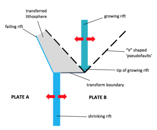
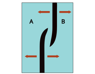
A propagating rift is a seafloor feature associated with spreading centers at mid-ocean ridges and back-arc basins. They are more commonly observed on faster rate spreading centers. These features are formed by the lengthening of one spreading segment at the expense of an offset neighboring spreading segment. Hence, these are remnant features produced by migration of the tip of a spreading center. In other words, as the tip of a spreading center migrates or grows, the plate itself grows at the expense of the shrinking plate, transferring lithosphere from the shrinking plate to the growing plate.

The Aleutian subduction zone is a 2,500 mi (4,000 km) long convergent boundary between the North American Plate and the Pacific Plate, that extends from the Alaska Range to the Kamchatka Peninsula. Here, the Pacific Plate is being subducted underneath the North American Plate and the rate of subduction changes from west to east from 7.5 to 5.1 cm per year. The Aleutian subduction zone includes two prominent features, the Aleutian Arc and the Aleutian Trench. The Aleutian Arc was created via volcanic eruptions from dehydration of the subducting slab at ~100 km depth. The Aleutian Trench is a narrow and deep morphology that occurs between the two converging plates as the subducting slab dives beneath the overriding plate.
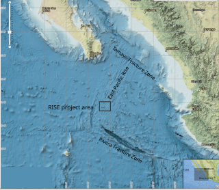
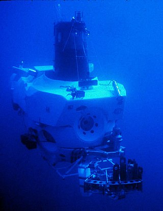
The RISE Project (Rivera Submersible Experiments) was a 1979 international marine research project which mapped and investigated seafloor spreading in the Pacific Ocean, at the crest of the East Pacific Rise (EPR) at 21° north latitude. Using a deep sea submersible (ALVIN) to search for hydrothermal activity at depths around 2600 meters, the project discovered a series of vents emitting dark mineral particles at extremely high temperatures which gave rise to the popular name, "black smokers". Biologic communities found at 21° N vents, based on chemosynthesis and similar to those found at the Galapagos spreading center, established that these communities are not unique. Discovery of a deep-sea ecosystem not based on sunlight spurred theories of the origin of life on Earth.

The central Montana Alkalic Province is located in the United States in central Montana. Montana is bordered by Idaho, Wyoming, North Dakota, South Dakota, and Canada to the north. Central Montana is unique when compared to the rest of the Rocky Mountains due to its east-west trend of tectonic features, including thrust fault zones, anticlines, and domes. The area of tectonic activity experienced conditions of plastic deformation, which affected the whole region. The Montana Alkalic Province consist of Cretaceous intrusions of monzonite and syenite as well as Cambrian limestone, sandstone, and siltstone. Most of the sedimentary rocks are a result of deposition from a terrestrial fluvial environment. Deposition included more than 13,000 feet of clastics that were later uplifted. The peak of this uplifting occurred during the Devonian. Deposition, uplift, and traps of carbonate shales have made central Montana prime for small-scale oil and gas production. Other geologic formations in this area include Judith Mountains, Crazy Mountains, Highwood Mountains, and Bears Paw Mountains. These areas include various igneous formations including xenoliths, laccoliths, and veins. Each mountain exhibits similar but unique geologic features.
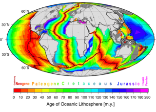
Marine geophysics is the scientific discipline that employs methods of geophysics to study the world's ocean basins and continental margins, particularly the solid earth beneath the ocean. It shares objectives with marine geology, which uses sedimentological, paleontological, and geochemical methods. Marine geophysical data analyses led to the theories of seafloor spreading and plate tectonics.
Cynthia Ebinger is an American geoscientist at Tulane University known for her research on continental rifts and the movement of continental plate boundaries.
Mathilde Cannat is a French geologist known for her research on the formation of oceanic crust and the tectonic and magmatic changes of mid-ocean ridges.
Roger Clive Searle is an English geophysicist, known for using sonar imaging in research on the geology and geophysics of the ocean floor. In particular, he has made important contributions to understanding the oceanic spreading system and the mid-ocean spreading centres.


