Bruce P. Luyendyk

Last updated
Bruce P. Luyendyk
B Luyendyk (New Zealand).jpg
Luyendyk during his visit to New Zealand.
Born1943 (age 7980)
NationalityAmerican
Alma materBSc San Diego State University
PhD University of California, San Diego
Known for
  • Ocean spreading centers
  • tectonic rotation of the California Transverse Ranges
  • tectonics of Marie Byrd Land, Antarctica
  • marine hydrocarbon seeps
Awards
Scientific career
Fields Marine geophysics
Tectonics
Institutions Woods Hole Oceanographic Institution
University of California - Santa Barbara
Website www.geol.ucsb.edu/people/bruce-luyendyk

Bruce Peter Luyendyk (born 1943) is an American geophysicist and oceanographer, currently professor emeritus of marine geophysics at the University of California, Santa Barbara. His work spans marine geology of the major ocean basins, the tectonics of southern California, marine hydrocarbon seeps, and the tectonics and paleoclimate of Antarctica. His research includes tectonic rotations of the California Transverse Ranges, participation in the discovery of deep-sea hydrothermal vents, [1] quantitative studies of marine hydrocarbon seeps, and geologic exploration of the Ford Ranges in Marie Byrd Land, Antarctica.

Contents

Antarctica's Mount Luyendyk is named in honor of his research in the area.

Early life and education

Bruce Luyendyk and his family moved to San Diego, California in 1956 where he continued his public-school education. Luyendyk attended San Diego State University (SDSU) where he obtained a bachelor's degree in geology and geophysics. He then attended the Scripps Institution of Oceanography (SIO) at the University of California, San Diego, where he earned his PhD in 1969. He studied under Fred Spiess and Henry Menard. That research employed the newly designed deep towed instrument package of the Marine Physical Lab. He followed his PhD with a postdoctoral fellowship at the Woods Hole Oceanographic Institution (WHOI). His supervisors were Carl Bowin and James Heirtzler. [2] [3]

Career and impact

While an undergraduate geology student at San Diego State, Luyendyk participated in marine geologic expedition PROA with SIO. That expedition, to the western and south Pacific, and led by Robert Fisher and William Riedel, inspired Luyendyk to follow an education and career in oceanography.

After his postdoctorate at WHOI, Luyendyk was appointed there as Assistant Scientist. He participated in the FAMOUS expeditions (FAMOUS: French-American Mid-Ocean Undersea Study) to the Mid-Atlantic Ridge where, along with Ken Macdonald, he mapped the rift valley with the Marine Physical Lab deep tow. [4]

California geology and tectonics — Luyendyk moved to UCSB in 1973, where he began research in southern California tectonics using paleomagnetism. His projects include documenting the ninety degree or greater clockwise rotation of the Transverse Ranges during the Neogene Period of the Cenozoic Era. [5]

Drilling into Deep Ocean Floor

— Luyendyk led two expeditions of the Deep Sea Drilling Project. [6] [7] Principal discoveries included that of a basin-wide unconformity of Oligocene age in the Indian Ocean that was likely related to initiation of ice sheets in Antarctica [8] and uplift of the Reykjanes Ridge due to the Iceland hot spot. Five holes drilled in the rift valley of the Mid Atlantic ridge recovered the youngest rock drilled at the time from the Atlantic sea floor, supporting models of sea floor spreading. [9]

Hydrothermal vents — In the late 1970s, Luyendyk joined Spiess and Macdonald and an international contingent in forming the RISE project (Rivera Submersible Experiments) to explore the East Pacific Rise at 21° N latitude with the WHOI submersible ALVIN. Here the team discovered deep-sea hydrothermal vents and associated “black smokers” chimneys. [1] This research earned the team the Newcomb Cleveland Prize from the American Association for the Advancement of Science (see 1980, Spiess, Macdonald and 20 coauthors). [10]

Marine hydrocarbon seeps — During the 1990s, Luyendyk and colleagues began a study of the marine hydrocarbon seep field at Coal Oil Point, California. The object was to quantify oil and natural gas emission from these submarine features. Their work determined that these are likely the largest known marine seeps. [11] They discovered a decrease in seepage over the prior two decades. They attributed this to ongoing oil and gas production from wells that penetrated the source reservoirs of the seep field. [12]

Antarctic research — In the late 1980s, Luyendyk and David Kimbrough of SDSU launched two expeditions to the Ford Ranges of Marie Byrd Land in West Antarctica. One rationale was to search out matching geologic features related to ones known in New Zealand, which once was joined in Gondwana to this part of Antarctica. Stephen M. Richard was a member of these two expeditions, known as FORCE (Ford Ranges Crustal Exploration). Antarctic geologist Christine Smith Siddoway accompanied them to conduct her graduate dissertation work on metamorphism and deformation within the Fosdick Mountains. Findings of this research include the history of development of the Fosdick Mountains migmatite gneiss dome [13] and Ford Ranges. [14] Follow-on research by others discerned the recent retreat of the West Antarctic Ice Sheet in the region, [15] [16] first noted here by the FORCE expeditions. [17]

Luyendyk led three marine research expeditions in the adjacent Ross Sea. [18] [19] [20] The expeditions focused upon remote and difficult-to-access sectors of Antarctica, bordering the southern Pacific Ocean. The marine surveys of the Coulman High, [21] carried out jointly with L. Bartek and D. S. Wilson, represented the opportunity for access to a sector of the Ross Sea that had been long-concealed beneath the Ross Ice Shelf. The expeditions followed closely upon the calving and breakout of the C-19 iceberg in 2002. Based on these surveys the ANDRILL program recommended a deep drill site within the surveyed area of Coulman High. [21]

In the later part of the 1990s, Luyendyk teamed with Andrea Donnellan of the Jet Propulsion Laboratory to use GPS to measure the rate of opening across the Ross Embayment between West and East Antarctica. They found no stretching within the margins for error but did detect vertical motion due to post glacial isostatic rebound. [22]

In the early 2000s, Luyendyk, along with D.S. Wilson and C. Siddoway, made aerogeophysical and linked ground surveys in the greater region of the Ford Ranges. [23] These surveys revealed buried features that gave clues to the tectonic history of the region. Data from the survey were incorporated into the new bedrock map of Antarctica known as Bedmap2. [24] Achieved through joint work with Douglas S. Wilson, revelations about the topography of the subglacial and nearshore marine environments of the eastern Ross Sea led to an interpretation of paleotopography at a time of climate transition that preceded continental glaciation of Antarctica. [25] The work provided a basis for a climate model for the development of the early Antarctic Ice Sheet. [26]

Zealandia — In 1995, Luyendyk proposed a model for the fragmentation of Gondwana that included the New Zealand microcontinent and several other pieces of continental crust. He collectively named the now submerged continent that includes the nation of New Zealand, Zealandia. [27] Since that time, New Zealand geologists have made the case that their nation sits atop the world’s eighth continent. [28] [29]

Awards and honors

Luyendyk shared the Newcomb Cleveland Prize of the American Association for the Advancement of Science in 1980. [10]

Luyendyk was elected Fellow of the Geological Society of America in 1975. [30]

In 2002 he was elected a Fellow of the American Geophysical Union. [31]

In 2016, the U.S. Board of Geographic Names recognized Luyendyk’s contributions to Antarctic science with a name designation, Mount Luyendyk, to a summit in Marie Byrd Land. [32]

In 2018 he was elected a Fellow of the American Association for the Advancement of Science. [33]

Professional leadership

Luyendyk has held a succession of science administration positions during his academic career, including founding Director of the Institute for Crustal Studies (1988-1997; now Earth Research Institute) and Chair of the Department of Geological Sciences at UC Santa Barbara (1997-2003; now Earth Science), followed by a term as Associate Dean of Mathematical, Life, and Physical Sciences at UC Santa Barbara (2005-2010). His professional service included service for international Antarctic research. He served on the ANDRILL (Antarctic Drilling) Science Committee for a decade, beginning in 2005, and he led the USA's work in hosting the 10th International Symposium on Antarctic Earth Sciences in Santa Barbara, CA, in 2007. [34] The ISAES returned to USA after a hiatus of thirty years since the first USA-hosted symposium in 1977, in Madison, WI. The 2007 conference was the first to publish the Symposium volume in digital format, on-line. [34]

Selected works

Related Research Articles

<span class="mw-page-title-main">Ross Sea</span> Deep bay of the Southern Ocean in Antarctica

The Ross Sea is a deep bay of the Southern Ocean in Antarctica, between Victoria Land and Marie Byrd Land and within the Ross Embayment, and is the southernmost sea on Earth. It derives its name from the British explorer James Clark Ross who visited this area in 1841. To the west of the sea lies Ross Island and Victoria Land, to the east Roosevelt Island and Edward VII Peninsula in Marie Byrd Land, while the southernmost part is covered by the Ross Ice Shelf, and is about 200 miles (320 km) from the South Pole. Its boundaries and area have been defined by the New Zealand National Institute of Water and Atmospheric Research as having an area of 637,000 square kilometres (246,000 sq mi).

<span class="mw-page-title-main">Deep Sea Drilling Project</span> Ocean drilling research program between 1966–1983

The Deep Sea Drilling Project (DSDP) was an ocean drilling project operated from 1968 to 1983. The program was a success, as evidenced by the data and publications that have resulted from it. The data are now hosted by Texas A&M University, although the program was coordinated by the Scripps Institution of Oceanography at the University of California, San Diego. DSDP provided crucial data to support the seafloor spreading hypothesis and helped to prove the theory of plate tectonics. DSDP was the first of three international scientific ocean drilling programs that have operated over more than 40 years. It was followed by the Ocean Drilling Program (ODP) in 1985, the Integrated Ocean Drilling Program in 2004 and the present International Ocean Discovery Program in 2013.
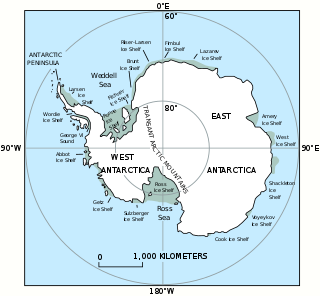
<span class="mw-page-title-main">West Antarctic Ice Sheet</span> Segment of the continental ice sheet that covers West (or Lesser) Antarctica

The Western Antarctic Ice Sheet (WAIS) is the segment of the continental ice sheet that covers West Antarctica, the portion of Antarctica on the side of the Transantarctic Mountains that lies in the Western Hemisphere. The WAIS is classified as a marine-based ice sheet, meaning that its bed lies well below sea level and its edges flow into floating ice shelves. The WAIS is bounded by the Ross Ice Shelf, the Ronne Ice Shelf, and outlet glaciers that drain into the Amundsen Sea.

<span class="mw-page-title-main">Marie Byrd Land</span> Unclaimed West Antarctic region

Marie Byrd Land (MBL) is an unclaimed region of Antarctica. With an area of 1,610,000 km2 (620,000 sq mi), it is the largest unclaimed territory on Earth. It was named after the wife of American naval officer Richard E. Byrd, who explored the region in the early 20th century.

<span class="mw-page-title-main">Fosdick Mountains</span> Mountain range in Marie Byrd Land, Antarctica

The Fosdick Mountains are an east–west trending mountain range with marked serrate outlines, standing along the south side of Balchen Glacier at the head of Block Bay, in the Ford Ranges of Marie Byrd Land, Antarctica. They were discovered by the Byrd Antarctic Expedition in 1929, and named by Richard E. Byrd for Raymond B. Fosdick, who became president of the Rockefeller Foundation.

<span class="mw-page-title-main">Cape Colbeck</span> Headland of Antarctica

Cape Colbeck is a prominent ice-covered cape which forms the northwestern extremity of the Edward VII Peninsula and Marie Byrd Land in Antarctica. It was discovered in January 1902 by the British National Antarctic Expedition and named for Captain William Colbeck, Royal Naval Reserve, who commanded Robert Scott's relief ship, the Morning.

<span class="mw-page-title-main">West Antarctic Rift System</span> Series of rift valleys between East and West Antarctica

The West Antarctic Rift System is a series of rift valleys between East and West Antarctica. It encompasses the Ross Embayment, the Ross Sea, the area under the Ross Ice Shelf and a part of Marie Byrd Land in West Antarctica, reaching to the base of the Antarctic Peninsula. It has an estimated length of 3,000 km (1,900 mi) and a width of approximately 700 km (430 mi). Its evolution is due to lithospheric thinning of an area of Antarctica that resulted in the demarcation of East and West Antarctica. The scale and evolution of the rift system has been compared to that of the Basin and Range Province of the Western United States.

<span class="mw-page-title-main">Geology of Antarctica</span> Geologic composition of Antarctica

The geology of Antarctica covers the geological development of the continent through the Archean, Proterozoic and Phanerozoic eons.

<span class="mw-page-title-main">Fred Spiess</span> American marine biologist

Dr. Fred Noel Spiess was a naval officer, oceanographer and marine explorer. His work created new advances in marine technology including the FLIP Floating Instrument Platform, the Deep Tow vehicle for study of the seafloor, and the use of acoustics for underwater navigation and geodetic positioning.

<span class="mw-page-title-main">The Billboard</span>

The Billboard is a massive granite monolith in the Sarnoff Mountains of the Ford Ranges of Marie Byrd Land, West Antarctica, standing just west of Mount Rea between Arthur Glacier and Boyd Glacier. It was discovered in November 1934 by a Second Byrd Antarctic Expedition (1933–35) sledge party under Paul Siple, and is so named because of its form and appearance with vertical faces rising above the continental ice.

Phillips Mountains is a range of mountains on the north side of Balchen Glacier and Block Bay in the Ford Ranges, Marie Byrd Land, West Antarctica. Discovered by the Byrd Antarctic Expedition (1928–30) and named by Byrd for Albanus Phillips, Sr., a manufacturer in Cambridge, Maryland, United States, and patron of the Byrd expeditions.

<span class="mw-page-title-main">East Antarctic Shield</span> Cratonic rock body which makes up most of the continent Antarctica

The East Antarctic Shield or Craton is a cratonic rock body that covers 10.2 million square kilometers or roughly 73% of the continent of Antarctica. The shield is almost entirely buried by the East Antarctic Ice Sheet that has an average thickness of 2200 meters but reaches up to 4700 meters in some locations. East Antarctica is separated from West Antarctica by the 100–300 kilometer wide Transantarctic Mountains, which span nearly 3,500 kilometers from the Weddell Sea to the Ross Sea. The East Antarctic Shield is then divided into an extensive central craton that occupies most of the continental interior and various other marginal cratons that are exposed along the coast.

<span class="mw-page-title-main">Christine Siddoway</span> American Antarctic researcher

Christine Siddoway is an American Antarctic researcher, best known for her work on the geology and tectonics of the Ford Ranges in western Marie Byrd Land. Other discoveries relate to preserved records of continental-interior sedimentation during the Sturtian glaciation, Cryogenian Period, in Rodinia, and evidence of a reduced Pliocene extent of the West Antarctic ice sheet, based upon investigation of clasts transported to/deposited in deep water by Ice rafting in the Amundsen Sea.

<span class="mw-page-title-main">Mount Luyendyk</span> Mountain in Marie Byrd Land, Antarctica

Mount Luyendyk is a summit in the western Fosdick Mountains of the Ford Ranges of Marie Byrd Land, West Antarctica. It forms a prominent exposure in the northwestern Iphigene massif. The peak is named in recognition of Bruce P. Luyendyk, professor (emeritus), University of California, Santa Barbara, who was active in ground- and ocean-based Antarctic research from 1989 to 2015, significantly advancing the scientific knowledge of the Ross Embayment region of Antarctica. Luyendyk led two on-land expeditions in the Ford Ranges, and was principal investigator for five marine geophysical expeditions in the Ross Sea.

<span class="mw-page-title-main">Kenneth C. Macdonald</span> American oceanographer (born 1947)

Kenneth Craig Macdonald is an American oceanographer and marine geophysicist born in San Francisco, California in 1947. As of 2018 he is professor emeritus at the Department of Earth Science and the Marine Sciences Institute at the University of California, Santa Barbara (UCSB). His work focuses on the tectonics and geophysics of the global mid-oceanic ridge including its spreading centers and transform faults, two of the three types of plate boundaries central to the theory of plate tectonics. His work has taken him to the north and south Atlantic oceans, the north and south Pacific oceans, the Indian Ocean, the Red Sea and the Sea of Cortez, as well as to the deep seafloor on over 50 dives in the research submersible ALVIN. Macdonald has participated in over 40 deep sea expeditions, and was chief- or co-chief scientist on 31 expeditions.

<span class="mw-page-title-main">Ross Embayment</span> Region of Antarctica

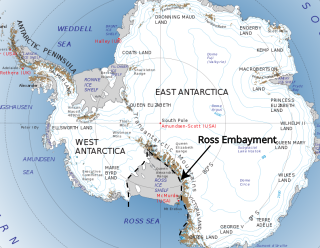
The Ross Embayment is a large region of Antarctica, comprising the Ross Ice Shelf and the Ross Sea, that lies between East and West Antarctica.

<span class="mw-page-title-main">RISE project</span> 1979 international marine research project

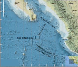
The RISE Project (Rivera Submersible Experiments) was a 1979 international marine research project which mapped and investigated seafloor spreading in the Pacific Ocean, at the crest of the East Pacific Rise (EPR) at 21° north latitude. Using a deep sea submersible (ALVIN) to search for hydrothermal activity at depths around 2600 meters, the project discovered a series of vents emitting dark mineral particles at extremely high temperatures which gave rise to the popular name, "black smokers". Biologic communities found at 21° N vents, based on chemosynthesis and similar to those found at the Galapagos spreading center, established that these communities are not unique. Discovery of a deep-sea ecosystem not based on sunlight spurred theories of the origin of life on Earth.

<span class="mw-page-title-main">Project FAMOUS</span> Marine scientific exploration by manned submersibles of a diverging tectonic plate boundary

Project FAMOUS was the first-ever marine scientific exploration by manned submersibles of a diverging tectonic plate boundary on a mid-ocean ridge. It took place between 1971 and 1974, with a multi-national team of scientists concentrating numerous underwater surveys on an area of the Mid-Atlantic Ridge about 700 kilometers west of the Azores. By deploying new methods and specialized equipment, scientists were able to look at the sea floor in far greater detail than ever before. The project succeeded in defining the main mechanisms of creation of the median rift valley on the Mid-Atlantic Ridge, and in locating and mapping the zone of oceanic crustal accretion.

<span class="mw-page-title-main">Amelia E. Shevenell</span> American marine geologist

Amelia E. Shevenell is an American marine geologist who specializes in high-latitude paleoclimatology and paleoceanography. She is currently a Professor in the College of Marine Science at the University of South Florida. She has made notable contributions to understanding the history of the Antarctic ice sheets and published in high-impact journals and, as a result, was awarded full membership of Sigma Xi. She has a long record of participation in international ocean drilling programs and has served in leadership positions of these organizations. Shevenell served as the elected Geological Oceanography Council Member for The Oceanography Society (2019-2021).

<span class="mw-page-title-main">Marine geophysics</span>

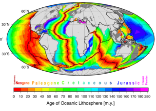
Marine geophysics is the scientific discipline that employs methods of geophysics to study the world's ocean basins and continental margins, particularly the solid earth beneath the ocean. It shares objectives with marine geology, which uses sedimentological, paleontological, and geochemical methods. Marine geophysical data analyses led to the theories of seafloor spreading and plate tectonics.

References

  1. 1 2 F. N. Spiess, Ken C. Macdonald, T. Atwater, R. Ballard, A. Carranza, D. Cordoba, C. Cox, V. M. Diaz Garcia, J. Francheteau, J. Guerrero, J. Hawkins, R. Haymon R. Hessler, T. Juteau, M. Kastner, R. Larson, B. Luyendyk, J.D. Macdougall, S. Miller, W. Normark, J. Orcutt, C. Rangin, Hot Springs and geophysical experiments on the East Pacific Rise. Science, 207: 1421-1444, 1980.
  2. "Profile: Carl Bowin". www.whoi.edu. Retrieved October 12, 2017.
  3. "A Guide to the Papers of James Ransom Heirtzler". dlaweb.whoi.edu. Retrieved 13 October 2017.
  4. Luyendyk, B.; Macdonald, K. C. (1977-05-01). "Physiography and structure of the inner floor of the FAMOUS rift valley: Observations with a deep-towed instrument package". GSA Bulletin. 88 (5): 648. Bibcode:1977GSAB...88..648L. doi:10.1130/0016-7606(1977)88<648:pasoti>2.0.co;2. ISSN   0016-7606.
  5. Luyendyk, Bruce P.; Kamerling, Marc J.; Terres, Richard R.; Hornafius, J. Scott (1985-12-10). "Simple shear of southern California during Neogene time suggested by paleomagnetic declinations". Journal of Geophysical Research: Solid Earth. 90 (B14): 12454–12466. Bibcode:1985JGR....9012454L. doi:10.1029/jb090ib14p12454. ISSN   2156-2202.
  6. Luyendyk B. and Davies, T, and Scientific Party (1974). "Introduction and Principal Results: Leg 26 Deep Sea Drilling Project" (PDF). Initial Reports of the Deep Sea Drilling Project, 26. Initial Reports of the Deep Sea Drilling Project. Vol. 26. doi:10.2973/dsdp.proc.26.101.1974.{{cite book}}: CS1 maint: multiple names: authors list (link)
  7. Luyendyk, B., Cann, J. and Sharman, G. (1979). "Introduction: Background and Explanatory Notes" (PDF). Initial Reports of the Deep Sea Drilling Project, 49. Initial Reports of the Deep Sea Drilling Project. Vol. 49. doi:10.2973/dsdp.proc.49.101.1979.{{cite book}}: CS1 maint: multiple names: authors list (link)
  8. Davies, Thomas A.; Weser, Oscar E.; Luyendyk, Bruce P.; Kidd, Robert B. (1975). "Unconformities in the sediments of the Indian Ocean". Nature. 253 (5486): 15–19. Bibcode:1975Natur.253...15D. doi:10.1038/253015a0. ISSN   1476-4687. S2CID   4168672.
  9. Luyendyk, B. P.; Shor, A.; Cann, J. R. (1979). "Chapter 37. General implications of the Leg 49 drilling program for North Atlantic Ocean geology". Initial Reports of the Deep Sea Drilling Project. Vol. 49. Washington, U.S. Government Printing Office. doi:10.2973/dsdp.proc.49.137.1979.
  10. 1 2 "Recipients Newcomb Cleveland Prize AAAS".
  11. Hornafius, J.S., Quigley, D. and Luyendyk, B.P., The World’s Most Spectacular Marine Hydrocarbon Seeps (Coal Oil Point, Santa Barbara Channel, California): Quantification of Emissions, J. Geophys. Res. - Oceans 104: 20,703-20,711, 1999.
  12. Quigley, Derek C.; Hornafius, J. Scott; Luyendyk, Bruce P.; Francis, Robert D.; Clark, Jordan; Washburn, Libe (1999-11-01). "Decrease in natural marine hydrocarbon seepage near Coal Oil Point, California, associated with offshore oil production". Geology. 27 (11): 1047. Bibcode:1999Geo....27.1047Q. doi:10.1130/0091-7613(1999)027<1047:dinmhs>2.3.co;2. ISSN   0091-7613. S2CID   16780749.
  13. Siddoway, C.S; Richard, S.; Fanning, C.M.; and Luyendyk, B. P. 2004, Origin and emplacement mechanisms for a middle Cretaceous gneiss dome, Fosdick Mountains, West Antarctica, in Whitney, D.L., Teyssier, C.T., and Siddoway, C., eds., Gneiss domes in orogeny, GSA Special Paper 380, Chapter 16, p. 267-294.
  14. Siddoway, C., 2008, Tectonics of the West Antarctic rift system: New light on the history and dynamics of distributed intracontinental extension, in Cooper, A. et al., Antarctica: A Keystone in a Changing World, National Academy of Sciences, Washington, D.C., pp. 91-114.
  15. Stone, John O.; Balco, Gregory A.; Sugden, David E.; Caffee, Marc W.; Sass, Louis C.; Cowdery, Seth G.; Siddoway, Christine (2003-01-03). "Holocene Deglaciation of Marie Byrd Land, West Antarctica". Science. 299 (5603): 99–102. Bibcode:2003Sci...299...99S. doi:10.1126/science.1077998. hdl: 1842/461 . ISSN   0036-8075. PMID   12511648. S2CID   30462902.
  16. Sugden, David E.; Balco, Greg; Cowdery, Seth G.; Stone, John O.; Sass, Louis C. (2005). "Selective glacial erosion and weathering zones in the coastal mountains of Marie Byrd Land, Antarctica". Geomorphology. 67 (3–4): 317–334. Bibcode:2005Geomo..67..317S. doi:10.1016/j.geomorph.2004.10.007.
  17. Richard, S.M., and Luyendyk, B.P., Glacial flow reorientation in the southwest Fosdick Mountains, Ford Ranges, Marie Byrd Land. Antarctic Journal of the United States, v. 26, no. 5, 67-69, 1991.
  18. "NSF Award OPP 9316712".
  19. "Marine Geoscience Data System NBP0301".
  20. "Marine Geoscience Data System NBP0306".
  21. 1 2 Luyendyk, B. P., D. S. Wilson, R. C. Decesari, C. C. Sorlien, and L. R. Bartek_III (2007), Proposed ANDRILL sites on Coulman High, Ross Sea, Antarctica, in Program Book for the 10th International Symposium on Start Earth Sciences: Antarctica: A Keystone in a Changing World Online Proceedings of the 10th ISAES, 141 pp., edited by A. K. Cooper, C.R. Raymond et al., USGS Open File Report 2007-1047, p. 100.
  22. Donnellan, Andrea; Luyendyk, Bruce P (2004). "GPS evidence for a coherent Antarctic plate and for postglacial rebound in Marie Byrd Land". Global and Planetary Change. 42 (1–4): 305–311. Bibcode:2004GPC....42..305D. doi:10.1016/j.gloplacha.2004.02.006.
  23. Luyendyk, Bruce P.; Wilson, Douglas S.; Siddoway, Christine S. (2003-10-01). "Eastern margin of the Ross Sea Rift in western Marie Byrd Land, Antarctica: Crustal structure and tectonic development". Geochemistry, Geophysics, Geosystems. 4 (10): 1090. Bibcode:2003GGG.....4.1090L. doi: 10.1029/2002gc000462 . ISSN   1525-2027.
  24. Fretwell, P., Pritchard, H. D., Vaughan, D. G., Bamber, J. L., Barrand, N. E., Bell, R., Bianchi, C., Bingham, R. G., Blankenship, D. D., Casassa, G., Catania, G., Callens, D., Conway, H., Cook, A. J., Corr, H. F. J., Damaske, D., Damm, V., Ferraccioli, F., Forsberg, R., Fujita, S., Gim, Y., Gogineni, P., Griggs, J. A., Hindmarsh, R. C. A., Holmlund, P., Holt, J. W., Jacobel, R. W., Jenkins, A., Jokat, W., Jordan, T., King, E. C., Kohler, J., Krabill, W., Riger-Kusk, M., Langley, K. A., Leitchenkov, G., Leuschen, C., Luyendyk, B. P., Matsuoka, K., Mouginot, J., Nitsche, F. O., Nogi, Y., Nost, O. A., Popov, S. V., Rignot, E., Rippin, D. M., Riviera, A., Roberts, J., Ross, N., Siegert, M. J., Smith, A. M., Steinhage, D., Studinger, M., Sun, B., Tinto, B. K., Welch, B. C., Wilson, D., Young, D. A., Xiangbin, C., and Zirizzotti, A., 2013, Bedmap2: improved ice bed, surface and thickness datasets for Antarctica: The Cryosphere, v. 7, p. 375-393.
  25. Wilson, Douglas S.; Luyendyk, Bruce P. (2009-08-01). "West Antarctic paleotopography estimated at the Eocene-Oligocene climate transition". Geophysical Research Letters. 36 (16): L16302. Bibcode:2009GeoRL..3616302W. doi:10.1029/2009gl039297. ISSN   1944-8007. S2CID   163074.
  26. Wilson, Douglas S.; Pollard, David; DeConto, Robert M.; Jamieson, Stewart S.R.; Luyendyk, Bruce P. (2013-08-28). "Initiation of the West Antarctic Ice Sheet and estimates of total Antarctic ice volume in the earliest Oligocene" (PDF). Geophysical Research Letters. 40 (16): 4305–4309. Bibcode:2013GeoRL..40.4305W. doi:10.1002/grl.50797. ISSN   1944-8007. S2CID   53465262.
  27. Luyendyk, Bruce P. (1995-04-01). "Hypothesis for Cretaceous rifting of east Gondwana caused by subducted slab capture". Geology. 23 (4): 373–376. Bibcode:1995Geo....23..373L. doi:10.1130/0091-7613(1995)023<0373:hfcroe>2.3.co;2. ISSN   0091-7613.
  28. Mortimer, N., and Campbell, H. (2014) Zealandia: Our continent revealed. Auckland: Penguin Books (NZ)
  29. Mortimer, Nick; Campbell, Hamish J.; Tulloch, Andy J.; King, Peter R.; Stagpoole, Vaughan M.; Wood, Ray A.; Rattenbury, Mark S.; Sutherland, Rupert; Adams, Chris J.; Collot, Julien; Seton, Maria (2017-03-01). "Zealandia: Earth's Hidden Continent". GSA Today: 27–35. doi:10.1130/GSATG321A.1. Archived from the original on 2018-06-11. Retrieved 2021-05-30.
  30. "ALL ACTIVE AND CURRENT GSA FELLOWS". Geological Society of America. Archived from the original on 27 September 2018. Retrieved 10 March 2018.
  31. "Fellow BRUCE P. LUYENDYK". American Geophysical Union. Retrieved 10 March 2018.
  32. "Antarctica Feature Detail". United States Geographical Survey. Retrieved 25 June 2017.
  33. "AAAS Honors Accomplished Scientists as 2018 Elected Fellows". American Association for the Advancement of Science. Retrieved 30 November 2018.
  34. 1 2 Bell, Robin E.; Luyendyk, Bruce P.; Wilson, Terry J. (2008-01-01). "Antarctica: A Keystone in a Changing World: 10th International Symposium on Antarctic Earth Sciences; Santa Barbara, California, 26 August to 1 September 2007". Eos, Transactions American Geophysical Union. 89 (1): 4. doi: 10.1029/2008eo010005 . ISSN   2324-9250.

Further reading