Hotspot (geology)

Last updated
Diagram showing a cross section through Earth at the Hawaii hotspot. Magma originating in the mantle rises into the asthenosphere and lithosphere. A chain of volcanoes is created as the lithosphere moves over the source of magma. Hawaii hotspot cross-sectional diagram.jpg
Diagram showing a cross section through Earth at the Hawaii hotspot. Magma originating in the mantle rises into the asthenosphere and lithosphere. A chain of volcanoes is created as the lithosphere moves over the source of magma.

In geology, hotspots (or hot spots) are volcanic locales thought to be fed by underlying mantle that is anomalously hot compared with the surrounding mantle. [1] Examples include the Hawaii, Iceland, and Yellowstone hotspots. A hotspot's position on the Earth's surface is independent of tectonic plate boundaries, and so hotspots may create a chain of volcanoes as the plates move above them.

Contents

There are two hypotheses that attempt to explain their origins. One suggests that hotspots are due to mantle plumes that rise as thermal diapirs from the core–mantle boundary. [2] The alternative plate theory is that the mantle source beneath a hotspot is not anomalously hot, rather the crust above is unusually weak or thin, so that lithospheric extension permits the passive rising of melt from shallow depths. [3] [4]

Origin

Schematic diagram showing the physical processes inside the Earth that lead to the generation of magma. Partial melting begins above the fusion point. Partial melting asthenosphere EN.svg
Schematic diagram showing the physical processes inside the Earth that lead to the generation of magma. Partial melting begins above the fusion point.
Map showing approximate location of many current hotspots and the relationship to current tectonic plates and their boundaries and movement vectors Tectonic plates boundaries physical World map Wt 180degE centered-en.svg
Map showing approximate location of many current hotspots and the relationship to current tectonic plates and their boundaries and movement vectors

The origins of the concept of hotspots lie in the work of J. Tuzo Wilson, who postulated in 1963 that the formation of the Hawaiian Islands resulted from the slow movement of a tectonic plate across a hot region beneath the surface. [5] It was later postulated that hotspots are fed by streams of hot mantle rising from the Earth's core–mantle boundary in a structure called a mantle plume. [6] Whether or not such mantle plumes exist has been the subject of a major controversy in Earth science, [4] [7] but seismic images consistent with evolving theory now exist. [8]

At any place where volcanism is not linked to a constructive or destructive plate margin, the concept of a hotspot has been used to explain its origin. A review article by Courtillot et al. [9] listing possible hotspots makes a distinction between primary hotspots coming from deep within the mantle and secondary hotspots derived from mantle plumes. The primary hotspots originate from the core/mantle boundary and create large volcanic provinces with linear tracks (Easter Island, Iceland, Hawaii, Afar, Louisville, Reunion, and Tristan confirmed; Galapagos, Kerguelen and Marquersas likely). The secondary hotspots originate at the upper/lower mantle boundary, and do not form large volcanic provinces, but island chains (Samoa, Tahiti, Cook, Pitcairn, Caroline, MacDonald confirmed, with up to 20 or so more possible). Other potential hotspots are the result of shallow mantle material surfacing in areas of lithospheric break-up caused by tension and are thus a very different type of volcanism.

Estimates for the number of hotspots postulated to be fed by mantle plumes have ranged from about 20 to several thousand, with most geologists considering a few tens to exist. [8] Hawaii, Réunion, Yellowstone, Galápagos, and Iceland are some of the most active volcanic regions to which the hypothesis is applied. The plumes imaged to date vary widely in width and other characteristics, and are tilted, being not the simple, relatively narrow and purely thermal plumes many expected. [8] Only one, (Yellowstone) has as yet been consistently modelled and imaged from deep mantle to surface. [8]

Composition

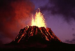
Most hotspot volcanoes are basaltic (e.g., Hawaii, Tahiti). As a result, they are less explosive than subduction zone volcanoes, in which water is trapped under the overriding plate. Where hotspots occur in continental regions, basaltic magma rises through the continental crust, which melts to form rhyolites. These rhyolites can form violent eruptions. [10] [11] For example, the Yellowstone Caldera was formed by some of the most powerful volcanic explosions in geologic history. However, when the rhyolite is completely erupted, it may be followed by eruptions of basaltic magma rising through the same lithospheric fissures (cracks in the lithosphere). An example of this activity is the Ilgachuz Range in British Columbia, which was created by an early complex series of trachyte and rhyolite eruptions, and late extrusion of a sequence of basaltic lava flows. [12]

The hotspot hypothesis is now closely linked to the mantle plume hypothesis. [13] [8] The detailed compositional studies now possible on hotspot basalts have allowed linkage of samples over the wider areas often implicate in the later hypothesis, [14] and it's seismic imaging developments. [8]

Contrast with subduction zone island arcs

Hotspot volcanoes are considered to have a fundamentally different origin from island arc volcanoes. The latter form over subduction zones, at converging plate boundaries. When one oceanic plate meets another, the denser plate is forced downward into a deep ocean trench. This plate, as it is subducted, releases water into the base of the over-riding plate, and this water mixes with the rock, thus changing its composition causing some rock to melt and rise. It is this that fuels a chain of volcanoes, such as the Aleutian Islands, near Alaska.

Hotspot volcanic chains

Over millions of years, the Pacific Plate has moved over the Hawaii hotspot, creating a trail of underwater mountains that stretches across the Pacific. Hawaii hotspot.jpg
Over millions of years, the Pacific Plate has moved over the Hawaii hotspot, creating a trail of underwater mountains that stretches across the Pacific.
Kilauea is the most active shield volcano in the world. The volcano erupted from 1983 to 2018 and is part of the Hawaiian-Emperor seamount chain. Puu Oo cropped.jpg
Kilauea is the most active shield volcano in the world. The volcano erupted from 1983 to 2018 and is part of the Hawaiian–Emperor seamount chain.
Mauna Loa is a large shield volcano. Its last eruption was in 2022 and it is part of the Hawaiian-Emperor seamount chain. Mauna Loa Volcano.jpg
Mauna Loa is a large shield volcano. Its last eruption was in 2022 and it is part of the Hawaiian–Emperor seamount chain.
Bowie Seamount is a dormant submarine volcano and part of the Kodiak-Bowie Seamount chain. Bowie Seamount1.jpg
Bowie Seamount is a dormant submarine volcano and part of the Kodiak-Bowie Seamount chain.
Axial Seamount is the youngest seamount of the Cobb-Eickelberg Seamount chain. Its last eruption was in 2015. Axial Exaggerated Bathymetry.jpg
Axial Seamount is the youngest seamount of the Cobb–Eickelberg Seamount chain. Its last eruption was in 2015.
Mauna Kea is the tallest volcano in the Hawaiian-Emperor seamount chain. Many cinder cones have been emplaced around its summit. Mauna Kea from the ocean.jpg
Mauna Kea is the tallest volcano in the Hawaiian–Emperor seamount chain. Many cinder cones have been emplaced around its summit.
Hualalai is a massive shield volcano in the Hawaiian-Emperor seamount chain. Its last eruption was in 1801. Hualalai 1996.jpg
Hualalai is a massive shield volcano in the Hawaiian–Emperor seamount chain. Its last eruption was in 1801.

The joint mantle plume/hotspot hypothesis originally envisaged the feeder structures to be fixed relative to one another, with the continents and seafloor drifting overhead. The hypothesis thus predicts that time-progressive chains of volcanoes are developed on the surface. Examples are Yellowstone, which lies at the end of a chain of extinct calderas, which become progressively older to the west. Another example is the Hawaiian archipelago, where islands become progressively older and more deeply eroded to the northwest.

Geologists have tried to use hotspot volcanic chains to track the movement of the Earth's tectonic plates. This effort has been vexed by the lack of very long chains, by the fact that many are not time-progressive (e.g. the Galápagos) and by the fact that hotspots do not appear to be fixed relative to one another (e.g. Hawaii and Iceland). [15] That mantle plumes are much more complex than originally hypothesised and move independently of each other and plates is now used to explain such observations. [8]

In 2020, Wei et al. used seismic tomography to detect the oceanic plateau, formed about 100 million years ago by the hypothesized mantle plume head of the Hawaii-Emperor seamount chain, now subducted to a depth of 800 km under eastern Siberia. [16]

Postulated hotspot volcano chains

An example of mantle plume locations suggested by one recent group. Figure from Foulger (2010). CourtHotspots.png
An example of mantle plume locations suggested by one recent group. Figure from Foulger (2010).

List of volcanic regions postulated to be hotspots

Distribution of hotspots in the list to the left, with the numbers corresponding to those in the list. The Afar hotspot (29) is misplaced. Hotspots-more.jpg
Distribution of hotspots in the list to the left, with the numbers corresponding to those in the list. The Afar hotspot (29) is misplaced.

Eurasian Plate

African Plate

Antarctic Plate

South American Plate

North American Plate

Australian Plate

Nazca Plate

Pacific Plate

Over millions of years, the Pacific Plate has moved over the Bowie hotspot, creating the Kodiak-Bowie Seamount chain in the Gulf of Alaska. Kodiak-Bowie Seamounts.jpg
Over millions of years, the Pacific Plate has moved over the Bowie hotspot, creating the Kodiak–Bowie Seamount chain in the Gulf of Alaska.
The Hotspot highway in the south Pacific Ocean HotspotHighway.jpg
The Hotspot highway in the south Pacific Ocean

Former hotspots

See also


Related Research Articles

<span class="mw-page-title-main">Geography of Samoa</span>

The Samoan archipelago is a chain of 16 islands and numerous seamounts covering 3,123 km2 (1,206 sq mi) in the central South Pacific, south of the equator, about halfway between Hawaii and New Zealand, forming part of Polynesia and of the wider region of Oceania. The islands are Savaiʻi, Upolu, Tutuila, ’Uvea, Taʻū, Ofu, Olosega, Apolima, Manono, Nuʻutele, Niulakita, Nuʻulua, Namua, Fanuatapu, Rose Atoll, Nu'ulopa, as well as the submerged Vailuluʻu, Pasco banks, and Alexa Bank.

<span class="mw-page-title-main">Mantle plume</span> Upwelling of abnormally hot rock within Earths mantle

A mantle plume is a proposed mechanism of convection within the Earth's mantle, hypothesized to explain anomalous volcanism. Because the plume head partially melts on reaching shallow depths, a plume is often invoked as the cause of volcanic hotspots, such as Hawaii or Iceland, and large igneous provinces such as the Deccan and Siberian Traps. Some such volcanic regions lie far from tectonic plate boundaries, while others represent unusually large-volume volcanism near plate boundaries.

<span class="mw-page-title-main">Hawaiian–Emperor seamount chain</span> Pacific Ocean geologic feature

The Hawaiian–Emperor seamount chain is a mostly undersea mountain range in the Pacific Ocean that reaches above sea level in Hawaii. It is composed of the Hawaiian ridge, consisting of the islands of the Hawaiian chain northwest to Kure Atoll, and the Emperor Seamounts: together they form a vast underwater mountain region of islands and intervening seamounts, atolls, shallows, banks and reefs along a line trending southeast to northwest beneath the northern Pacific Ocean. The seamount chain, containing over 80 identified undersea volcanoes, stretches about 6,200 km (3,900 mi) from the Aleutian Trench off the coast of the Kamchatka peninsula in the far northwest Pacific to the Kamaʻehuakanaloa Seamount, the youngest volcano in the chain, which lies about 35 kilometres (22 mi) southeast of the Island of Hawaiʻi.

<span class="mw-page-title-main">Kerguelen hotspot</span> Hotspot under the Indian Ocean

The Kerguelen hotspot is a volcanic hotspot at the Kerguelen Plateau in the Southern Indian Ocean. The Kerguelen hotspot has produced basaltic lava for about 130 million years and has also produced the Kerguelen Islands, Naturaliste Plateau, Heard Island, the McDonald Islands, and Rajmahal Traps. One of the associated features, the Ninety East Ridge, is distinguished by its over 5,000 km (3,100 mi) length, being the longest linear tectonic feature on Earth. The total volume of magma erupted in 130 million years with associated features has been estimated to be about 25,000,000 km3 (6,000,000 cu mi). However, as well as large igneous provinces and seamounts the hotspot has interacted with other seafloor spreading features, so this volume figure has some uncertainty.

<span class="mw-page-title-main">Galápagos hotspot</span> Pacific volcanic hotspot

The Galápagos hotspot is a volcanic hotspot in the East Pacific Ocean responsible for the creation of the Galápagos Islands as well as three major aseismic ridge systems, Carnegie, Cocos and Malpelo which are on two tectonic plates. The hotspot is located near the Equator on the Nazca Plate not far from the divergent plate boundary with the Cocos Plate. The tectonic setting of the hotspot is complicated by the Galapagos Triple Junction of the Nazca and Cocos plates with the Pacific Plate. The movement of the plates over the hotspot is determined not solely by the spreading along the ridge but also by the relative motion between the Pacific Plate and the Cocos and Nazca Plates.

<span class="mw-page-title-main">New England hotspot</span> Volcanic hotspot in the North Atlantic Ocean

The New England hotspot, also referred to as the Great Meteor hotspot and sometimes the Monteregian hotspot, is a volcanic hotspot in the North Atlantic Ocean. It created the Monteregian Hills intrusions in Montreal and Montérégie, the White Mountains intrusions in New Hampshire, the New England and Corner Rise seamounts off the coast of North America, and the Seewarte Seamounts east of the Mid-Atlantic Ridge on the African Plate, the latter of which include its most recent eruptive center, the Great Meteor Seamount. The New England, Great Meteor, or Monteregian hotspot track has been used to estimate the movement of the North American Plate away from the African Plate from the early Cretaceous period to the present using the fixed hotspot reference frame.

<span class="mw-page-title-main">Hawaii hotspot</span> Volcanic hotspot near the Hawaiian Islands, in the Pacific Ocean

The Hawaiʻi hotspot is a volcanic hotspot located near the namesake Hawaiian Islands, in the northern Pacific Ocean. One of the best known and intensively studied hotspots in the world, the Hawaii plume is responsible for the creation of the Hawaiian–Emperor seamount chain, a 6,200-kilometer (3,900 mi) mostly undersea volcanic mountain range. Four of these volcanoes are active, two are dormant; more than 123 are extinct, most now preserved as atolls or seamounts. The chain extends from south of the island of Hawaiʻi to the edge of the Aleutian Trench, near the eastern coast of Russia.

<span class="mw-page-title-main">Southwest Indian Ridge</span> A mid-ocean ridge on the bed of the south-west Indian Ocean and south-east Atlantic Ocean

The Southwest Indian Ridge (SWIR) is a mid-ocean ridge located along the floors of the south-west Indian Ocean and south-east Atlantic Ocean. A divergent tectonic plate boundary separating the Somali Plate to the north from the Antarctic Plate to the south, the SWIR is characterised by ultra-slow spreading rates (only exceeding those of the Gakkel Ridge in the Arctic) combined with a fast lengthening of its axis between the two flanking triple junctions, Rodrigues (20°30′S70°00′E) in the Indian Ocean and Bouvet (54°17′S1°5′W) in the Atlantic Ocean.

<span class="mw-page-title-main">Southeast Indian Ridge</span> Mid-ocean ridge in the southern Indian Ocean

The Southeast Indian Ridge (SEIR) is a mid-ocean ridge in the southern Indian Ocean. A divergent tectonic plate boundary stretching almost 6,000 km (3,700 mi) between the Rodrigues Triple Junction in the Indian Ocean and the Macquarie Triple Junction in the Pacific Ocean, the SEIR forms the plate boundary between the Australian and Antarctic plates since the Oligocene (anomaly 13).

<span class="mw-page-title-main">Pitcairn hotspot</span>

The Pitcairn hotspot is a volcanic hotspot located in the south-central Pacific Ocean. Over the past 11 million years, it has formed the Pitcairn-Gambier hotspot chain. It is responsible for creating the Pitcairn Islands and two large seamounts named Adams and Bounty, as well as atolls at Moruroa, Fangataufa and the Gambier Islands. The hotspot is currently located at Adams and Bounty, which are ~60 kilometers East-Southeast of Pitcairn Island.

<span class="mw-page-title-main">Louisville Ridge</span> Chain of over 70 seamounts in the Southwest Pacific Ocean

The Louisville Ridge, often now referred to as the Louisville Seamount Chain, is an underwater chain of over 70 seamounts located in the Southwest portion of the Pacific Ocean. As one of the longest seamount chains on Earth it stretches some 4,300 km (2,700 mi) from the Pacific-Antarctic Ridge northwest to the Tonga-Kermadec Trench, where it subducts under the Indo-Australian Plate as part of the Pacific Plate. The chains formation is best explained by movement of the Pacific Plate over the Louisville hotspot although others had suggested by leakage of magma from the shallow mantle up through the Eltanin fracture zone, which it follows closely for some of its course.

<span class="mw-page-title-main">Louisville hotspot</span> Volcanic hotspot that formed the Louisville Ridge in the southern Pacific Ocean

The Louisville hotspot is a volcanic hotspot responsible for the volcanic activity that has formed the Louisville Ridge in the southern Pacific Ocean.

<span class="mw-page-title-main">Marquesas hotspot</span> Volcanic hotspot in the Pacific Ocean

The Marquesas hotspot is a volcanic hotspot in the southern Pacific Ocean. It is responsible for the creation of the Marquesas Islands – a group of eight main islands and several smaller ones – and a few seamounts. The islands and seamounts formed between 5.5 and 0.4 million years ago and constitute the northernmost volcanic chain in French Polynesia.

<span class="mw-page-title-main">Samoa hotspot</span> Volcanic hotspot located in the south Pacific Ocean

The Samoa hotspot is a volcanic hotspot located in the south Pacific Ocean. The hotspot model describes a hot upwelling plume of magma through the Earth's crust as an explanation of how volcanic islands are formed. The hotspot idea came from J. Tuzo Wilson in 1963 based on the Hawaiian Islands volcanic chain.

<span class="mw-page-title-main">Macdonald hotspot</span> Volcanic hotspot in the southern Pacific Ocean

The Macdonald hotspot is a volcanic hotspot in the southern Pacific Ocean. The hotspot was responsible for the formation of the Macdonald Seamount, and possibly the Austral-Cook Islands chain. It probably did not generate all of the volcanism in the Austral and Cook Islands as age data imply that several additional hotspots were needed to generate some volcanoes.

<span class="mw-page-title-main">Shona hotspot</span> Volcanic hotspot in the Atlantic Ocean

The Shona or Meteor hotspot is a volcanic hotspot located in the southern Atlantic Ocean. Its zig-zag-shaped hotspot track, a chain of seamounts and ridges, stretches from its current location at or near the southern end of the Mid-Atlantic Ridge to South Africa.

<span class="mw-page-title-main">Arago hotspot</span> Hotspot in the Pacific Ocean

Arago hotspot is a hotspot in the Pacific Ocean, presently located below the Arago seamount close to the island of Rurutu, French Polynesia.

Foundation Seamounts are a series of seamounts in the southern Pacific Ocean. Discovered in 1992, these seamounts form a 1,350 kilometres (840 mi) long chain which starts from the Pacific-Antarctic Ridge. Some of these seamounts may have once emerged from the ocean.

<span class="mw-page-title-main">Musicians Seamounts</span> Chain of seamounts in the Pacific Ocean, north of the Hawaiian Ridge

Musicians Seamounts are a chain of seamounts in the Pacific Ocean, north of the Hawaiian Ridge. There are about 65 seamounts, some of which are named after musicians. These seamounts exist in two chains, one of which has been attributed to a probably now-extinct hotspot called the Euterpe hotspot. Others may have formed in response to plate tectonics associated with the boundary between the Pacific Plate and the former Farallon Plate.

Intraplate volcanism is volcanism that takes place away from the margins of tectonic plates. Most volcanic activity takes place on plate margins, and there is broad consensus among geologists that this activity is explained well by the theory of plate tectonics. However, the origins of volcanic activity within plates remains controversial.

References

  1. "The source of Yellowstone's heat". USGS. 16 April 2018. Retrieved 14 June 2021.
  2. 1 2 W. J. Morgan (5 March 1971). "Convection Plumes in the Lower Mantle". Nature. 230 (5288): 42–43. Bibcode:1971Natur.230...42M. doi:10.1038/230042a0. S2CID   4145715.
  3. "Do plumes exist?" . Retrieved 25 April 2010.
  4. 1 2 3 Foulger, G.R. (2010). Plates vs. Plumes: A Geological Controversy. Wiley-Blackwell. ISBN   978-1-4051-6148-0.
  5. Wilson, J. Tuzo (1963). "A possible origin of the Hawaiian Islands" (PDF). Canadian Journal of Physics. 41 (6): 863–870. Bibcode:1963CaJPh..41..863W. doi:10.1139/p63-094.
  6. "Hotspots: Mantle thermal plumes". United States Geological Survey. 5 May 1999. Retrieved 15 May 2008.
  7. Wright, Laura (November 2000). "Earth's interior: Raising hot spots". Geotimes. American Geological Institute . Retrieved 15 June 2008.
  8. 1 2 3 4 5 6 7 Koppers, A.A.; Becker, T.W.; Jackson, M.G.; Konrad, K.; Müller, R.D.; Romanowicz, B.; Steinberger, B.; Whittaker, J.M. (2021). "Mantle plumes and their role in Earth processes" (PDF). Nature Reviews Earth & Environment. 2 (6): 382–401. Bibcode:2021NRvEE...2..382K. doi:10.1038/s43017-021-00168-6 . Retrieved 21 November 2023.
  9. 1 2 Courtillot, V.; Davaillie, A.; Besse, J.; Stock, J. (2003). "Three distinct types of hotspots in the Earth's mantle". Earth Planet. Sci. Lett. 205 (3–4): 295–308. Bibcode:2003E&PSL.205..295C. CiteSeerX   10.1.1.693.6042 . doi:10.1016/S0012-821X(02)01048-8.
  10. Donald Hyndman; David Hyndman (1 January 2016). Natural Hazards and Disasters. Cengage Learning. pp. 44–. ISBN   978-1-305-88818-0.
  11. Wolfgang Frisch; Martin Meschede; Ronald C. Blakey (2 November 2010). Plate Tectonics: Continental Drift and Mountain Building. Springer Science & Business Media. pp. 87–. ISBN   978-3-540-76504-2.
  12. Holbek, Peter (November 1983). "Report on Preliminary Geology and Geochemistry of the Ilga Claim Group" (PDF). Archived from the original (PDF) on 12 January 2014. Retrieved 15 June 2008.{{cite journal}}: Cite journal requires |journal= (help)
  13. Mainak Choudhuri; Michal Nemčok (22 August 2016). Mantle Plumes and Their Effects. Springer. pp. 18–. ISBN   978-3-319-44239-6.
  14. 1 2 3 Bredow, E; Steinberger, B (16 January 2018). "Variable melt production rate of the Kerguelen hotspot due to long-term plume-ridge interaction". Geophysical Research Letters. 45 (1): 126–36. Bibcode:2018GeoRL..45..126B. doi: 10.1002/2017GL075822 . hdl: 10852/70913 .
  15. Sager, William W. (4 June 2007). "Insight into Motion of the Hawaiian Hotspot from Paleomagnetism". www.MantlePlumes.org.
  16. Wei, Songqiao Shawn; Shearer, Peter M.; Lithgow-Bertelloni, Carolina; Stixrude, Lars; Tian, Dongdong (20 November 2020). "Oceanic plateau of the Hawaiian mantle plume head subducted to the uppermost lower mantle". Science. 370 (6519): 983–987. Bibcode:2020Sci...370..983W. doi:10.1126/science.abd0312. ISSN   0036-8075. PMID   33214281. S2CID   227059993.
  17. E. V. Verzhbitsky (2003). "Geothermal regime and genesis of the Ninety-East and Chagos-Laccadive ridges". Journal of Geodynamics. 35 (3): 289. Bibcode:2003JGeo...35..289V. doi:10.1016/S0264-3707(02)00068-6.
  18. 1 2 Carracedo, Juan Carlos; Troll, Valentin R. (1 January 2021). "North-East Atlantic Islands: The Macaronesian Archipelagos". Encyclopedia of Geology. pp. 674–699. doi:10.1016/B978-0-08-102908-4.00027-8. ISBN   9780081029091. S2CID   226588940.
  19. 1 2 3 4 5 6 7 8 9 10 11 12 13 14 15 16 17 18 19 20 21 22 23 24 25 26 27 28 29 30 31 32 33 34 35 36 37 38 39 40 41 42 43 44 45 46 47 48 49 50 51 52 53 54 55 56 57 58 59 60 61 W. J. Morgan and J. P. Morgan. "Plate velocities in hotspot reference frame: electronic supplement" (PDF). Retrieved 6 November 2011.
  20. Nielsen, Søren B.; Stephenson, Randell; Thomsen, Erik (13 December 2007). "Letter:Dynamics of Mid-Palaeocene North Atlantic rifting linked with European intra-plate deformations". Nature. 450 (7172): 1071–1074. Bibcode:2007Natur.450.1071N. doi:10.1038/nature06379. PMID   18075591. S2CID   4428980.
  21. O'Neill, C.; Müller, R. D.; Steinberger, B. (2003). "Revised Indian plate rotations based on the motion of Indian Ocean hotspots" (PDF). Earth and Planetary Science Letters. 215 (1–2): 151–168. Bibcode:2003E&PSL.215..151O. CiteSeerX   10.1.1.716.4910 . doi:10.1016/S0012-821X(03)00368-6. Archived from the original (PDF) on 26 July 2011.
  22. O'Connor, J. M.; le Roex, A. P. (1992). "South Atlantic hot spot-plume systems. 1: Distribution of volcanism in time and space". Earth and Planetary Science Letters. 113 (3): 343–364. Bibcode:1992E&PSL.113..343O. doi:10.1016/0012-821X(92)90138-L.
  23. Smith, Robert B.; Jordan, Michael; Steinberger, Bernhard; Puskas, Christine M.; Farrell, Jamie; Waite, Gregory P.; Husen, Stephan; Chang, Wu-Lung; O'Connell, Richard (20 November 2009). "Geodynamics of the Yellowstone hotspot and mantle plume: Seismic and GPS imaging, kinematics and mantle flow" (PDF). Journal of Volcanology and Geothermal Research. 188 (1–3): 26–56. Bibcode:2009JVGR..188...26S. doi:10.1016/j.jvolgeores.2009.08.020.
  24. "Catalogue of Canadian volcanoes- Anahim volcanic belt". Natural Resources Canada. Geological Survey of Canada. Archived from the original on 16 July 2011. Retrieved 14 June 2008.

Further reading