Volcanic cone

Last updated
Mayon Volcano in the Philippines has a symmetrical volcanic cone. Mt.Mayon tam3rd.jpg
Mayon Volcano in the Philippines has a symmetrical volcanic cone.

Volcanic cones are among the simplest volcanic landforms. They are built by ejecta from a volcanic vent, piling up around the vent in the shape of a cone with a central crater. Volcanic cones are of different types, depending upon the nature and size of the fragments ejected during the eruption. Types of volcanic cones include stratocones, spatter cones, tuff cones, and cinder cones. [1] [2]

Contents

Stratocone

Osorno volcano in Chile is an example of a well-developed stratocone. Landscape osorno petrohue 2.jpg
Osorno volcano in Chile is an example of a well-developed stratocone.

Stratocones are large cone-shaped volcanoes made up of lava flows, explosively erupted pyroclastic rocks, and igneous intrusives that are typically centered around a cylindrical vent. Unlike shield volcanoes, they are characterized by a steep profile and periodic, often alternating, explosive eruptions and effusive eruptions. Some have collapsed craters called calderas. The central core of a stratocone is commonly dominated by a central core of intrusive rocks that range from around 500 meters (1,600 ft) to over several kilometers in diameter. This central core is surrounded by multiple generations of lava flows, many of which are brecciated, and a wide range of pyroclastic rocks and reworked volcanic debris. The typical stratocone is an andesitic to dacitic volcano that is associated with subduction zones. They are also known as either stratified volcano,composite cone,bedded volcano,cone of mixed type or Vesuvian-type volcano. [1] [2]

Spatter cone

Pu`u `O`o, a cinder-and-spatter cone on Kilauea, Hawai`i Puu Oo cropped.jpg
Puʻu ʻŌʻō, a cinder-and-spatter cone on Kīlauea, Hawaiʻi

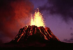
A spatter cone is a low, steep-sided hill or mound that consists of welded lava fragments, called spatter, which has formed around a lava fountain issuing from a central vent. Typically, spatter cones are about 3–5 meters (9.8–16.4 ft) high. In case of a linear fissure, lava fountaining will create broad embankments of spatter, called spatter ramparts, along both sides of the fissure. Spatter cones are more circular and cone shaped, while spatter ramparts are linear wall-like features. [1] [3] [4]

Spatter cones and spatter ramparts are typically formed by lava fountaining associated with mafic, highly fluid lavas, such as those erupted in the Hawaiian Islands. As blobs of molten lava, spatter, are erupted into the air by a lava fountain, they can lack the time needed to cool completely before hitting the ground. Consequently, the spatter are not fully solid, like taffy, as they land and they bind to the underlying spatter as both often slowly ooze down the side of the cone. As a result, the spatter builds up a cone that is composed of spatter either agglutinated or welded to each other. [1] [3] [4]

Tuff cones

Koko Crater is a tuff cone that is part of the Honolulu Volcanic Series. Koko Crater.jpg
Koko Crater is a tuff cone that is part of the Honolulu Volcanic Series.

A tuff cone, sometimes called an ash cone, is a small monogenetic volcanic cone produced by phreatic (hydrovolcanic) explosions directly associated with magma brought to the surface through a conduit from a deep-seated magma reservoir. They are characterized by high rims that have a maximum relief of 100–800 meters (330–2,620 ft) above the crater floor and steep slopes that are greater than 25 degrees. They typically have a rim to rim diameter of 300–5,000 meters (980–16,400 ft). A tuff cone consists typically of thick-bedded pyroclastic flow and surge deposits created by eruption-fed density currents and bomb-scoria beds derived from fallout from its eruption column. The tuffs composing a tuff cone have commonly been altered, palagonitized, by either its interaction with groundwater or when it was deposited warm and wet. The pyroclastic deposits of tuff cones differ from the pyroclastic deposits of spatter cones by their lack or paucity of lava spatter, smaller grain-size, and excellent bedding. Typically, but not always, tuff cones lack associated lava flows. [2] [5]

A tuff ring is a related type of small monogenetic volcano that is also produced by phreatic (hydrovolcanic) explosions directly associated with magma brought to the surface through a conduit from a deep-seated magma reservoir. They are characterized by rims that have a low, broad topographic profiles and gentle topographic slopes that are 25 degrees or less. The maximum thickness of the pyroclastic debris comprising the rim of a typical tuff ring is generally thin, less than 50 meters (160 ft) to 100 meters (330 ft) thick. The pyroclastic materials that comprise their rim consist primarily of relatively fresh and unaltered, distinctly and thin-bedded volcanic surge and air fall deposits. Their rims also can contain variable amounts of local country rock (bedrock) blasted out of their crater. In contrast to tuff cones, the crater of a tuff ring generally has been excavated below the existing ground surface. As a result, water commonly fills a tuff ring's crater to form a lake once eruptions cease. [2] [5]

Both tuff cones and their associated tuff rings were created by explosive eruptions from a vent where the magma is interacting with either groundwater or a shallow body of water as found within a lake or sea. The interaction between the magma, expanding steam, and volcanic gases resulted in the production and ejection of fine-grained pyroclastic debris called ash with the consistency of flour. The volcanic ash comprising a tuff cone accumulated either as fallout from eruption columns, from low-density volcanic surges and pyroclastic flows, or combination of these. Tuff cones are typically associated with volcanic eruptions within shallow bodies of water and tuff rings are associated with eruptions within either water saturated sediments and bedrock or permafrost. [2] [5] [6]

Next to spatter (scoria) cones, tuff cones and their associated tuff rings are among the most common types of volcanoes on Earth. An example of a tuff cone is Diamond Head at Waikīkī in Hawaiʻi. [2] Clusters of pitted cones observed in the Nephentes/Amenthes region of Mars at the southern margin of the ancient Utopia impact basin are currently interpreted as being tuff cones and rings. [7]

Cinder cone

Cinder cone Cinder cone volcano.jpg
Cinder cone
Paricutin is a large cinder cone in Mexico. Paricutin.jpg
Parícutin is a large cinder cone in Mexico.

Cinder cones, also known as scoria cones and less commonly scoria mounds, are small, steep-sided volcanic cones built of loose pyroclastic fragments, such as either volcanic clinkers, cinders, volcanic ash, or scoria. [1] [8] They consist of loose pyroclastic debris formed by explosive eruptions or lava fountains from a single, typically cylindrical, vent. As the gas-charged lava is blown violently into the air, it breaks into small fragments that solidify and fall as either cinders, clinkers, or scoria around the vent to form a cone that often is noticeably symmetrical; with slopes between 30 and 40°; and a nearly circular ground plan. Most cinder cones have a bowl-shaped crater at the summit. [1] The basal diameters of cinder cones average about 800 meters (2,600 ft) and range from 250 to 2,500 meters (820 to 8,200 ft). The diameter of their craters ranges between 50 and 600 meters (160 and 1,970 ft). Cinder cones rarely rise more than 50–350 meters (160–1,150 ft) or so above their surroundings. [2] [9]

Cinder cones most commonly occur as isolated cones in large basaltic volcanic fields. They also occur in nested clusters in association with complex tuff ring and maar complexes. Finally, they are also common as parasitic and monogenetic cones on complex shield and stratovolcanoes. Globally, cinder cones are the most typical volcanic landform found within continental intraplate volcanic fields and also occur in some subduction zone settings as well. Parícutin, the Mexican cinder cone which was born in a cornfield on February 20, 1943, and Sunset Crater in Northern Arizona in the US Southwest are classic examples of cinder cones, as are ancient volcanic cones found in New Mexico's Petroglyph National Monument. [2] [9] Cone-shaped hills observed in satellite imagery of the calderas and volcanic cones of Ulysses Patera, [10] Ulysses Colles [11] and Hydraotes Chaos [12] are argued to be cinder cones.

Cinder cones typically only erupt once like Parícutin. As a result, they are considered to be monogenetic volcanoes and most of them form monogenetic volcanic fields. Cinder cones are typically active for very brief periods of time before becoming inactive. Their eruptions range in duration from a few days to a few years. Of observed cinder cone eruptions, 50% have lasted for less than 30 days, and 95% stopped within one year. In case of Parícutin, its eruption lasted for nine years from 1943 to 1952. Rarely do they erupt either two, three, or more times. Later eruptions typically produce new cones within a volcanic field at separation distances of a few kilometers and separate by periods of 100 to 1,000 years. Within a volcanic field, eruptions can occur over a period of a million years. Once eruptions cease, being unconsolidated, cinder cones tend to erode rapidly unless further eruptions occur. [2] [9]

Rootless cones

Rootless cones, also called pseudocraters, are volcanic cones that are not directly associated with a conduit that brought magma to the surface from a deep-seated magma reservoir. Generally, three types of rootless cones, littoral cones , explosion craters, and hornitos are recognized. Littoral cones and explosion craters are the result of mild explosions that were generated locally by the interaction of either hot lava or pyroclastic flows with water. Littoral cones typically form on the surface of a basaltic lava flow where it has entered into a body of water, usually a sea or ocean. Explosion craters form where either hot lava or pyroclastic flows have covered either marshy ground or water-saturated ground of some sort. Hornitos are rootless cones that are composed of welded lava fragments and were formed on the surface of basaltic lava flows by the escape of gas and clots of molten lava through cracks or other openings in the crust of a lava flow. [1] [9] [13]

Related Research Articles

<span class="mw-page-title-main">Volcano</span> Rupture in the crust of a planet that allows lava, ash, and gases to escape from below the surface

A volcano is a rupture in the crust of a planetary-mass object, such as Earth, that allows hot lava, volcanic ash, and gases to escape from a magma chamber below the surface.

<span class="mw-page-title-main">Extrusive rock</span> Mode of igneous volcanic rock formation

Extrusive rock refers to the mode of igneous volcanic rock formation in which hot magma from inside the Earth flows out (extrudes) onto the surface as lava or explodes violently into the atmosphere to fall back as pyroclastics or tuff. In contrast, intrusive rock refers to rocks formed by magma which cools below the surface.

<span class="mw-page-title-main">Geology of the Lassen volcanic area</span> Geology of a U.S. national park in California

The Lassen volcanic area presents a geological record of sedimentation and volcanic activity in and around Lassen Volcanic National Park in Northern California, U.S. The park is located in the southernmost part of the Cascade Mountain Range in the Pacific Northwest region of the United States. Pacific Oceanic tectonic plates have plunged below the North American Plate in this part of North America for hundreds of millions of years. Heat and molten rock from these subducting plates has fed scores of volcanoes in California, Oregon, Washington and British Columbia over at least the past 30 million years, including these in the Lassen volcanic areas.

<span class="mw-page-title-main">Cinder Cone and the Fantastic Lava Beds</span> Cinder cone in the United States of America

Cinder Cone is a cinder cone volcano in Lassen Volcanic National Park within the United States. It is located about 10 mi (16 km) northeast of Lassen Peak and provides an excellent view of Brokeoff Mountain, Lassen Peak, and Chaos Crags.

<span class="mw-page-title-main">Belknap Crater</span> Shield volcano in the U.S. state of Oregon

Belknap Crater is a shield volcano in the Cascade Range in the U.S. state of Oregon. Located in Linn County, it is associated with lava fields and numerous subfeatures including the Little Belknap and South Belknap volcanic cones. It lies north of McKenzie Pass and forms part of the Mount Washington Wilderness. Belknap is not forested and most of its lava flows are not vegetated, though there is some wildlife in the area around the volcano, as well as a number of tree molds formed by its eruptive activity.

A monogenetic volcanic field is a type of volcanic field consisting of a group of small monogenetic volcanoes, each of which erupts only once, as opposed to polygenetic volcanoes, which erupt repeatedly over a period of time. The small monogenetic volcanoes of these fields are the most common subaerial volcanic landform.

<span class="mw-page-title-main">Types of volcanic eruptions</span> Overview of different types of volcanic eruptions

Several types of volcanic eruptions—during which lava, tephra, and assorted gases are expelled from a volcanic vent or fissure—have been distinguished by volcanologists. These are often named after famous volcanoes where that type of behavior has been observed. Some volcanoes may exhibit only one characteristic type of eruption during a period of activity, while others may display an entire sequence of types all in one eruptive series.

<span class="mw-page-title-main">Phreatomagmatic eruption</span> Volcanic eruption involving both steam and magma

Phreatomagmatic eruptions are volcanic eruptions resulting from interaction between magma and water. They differ from exclusively magmatic eruptions and phreatic eruptions. Unlike phreatic eruptions, the products of phreatomagmatic eruptions contain juvenile (magmatic) clasts. It is common for a large explosive eruption to have magmatic and phreatomagmatic components.

<span class="mw-page-title-main">Cinder cone</span> Steep hill of pyroclastic fragments around a volcanic vent

A cinder cone is a steep conical hill of loose pyroclastic fragments, such as volcanic clinkers, volcanic ash, or scoria that has been built around a volcanic vent. The pyroclastic fragments are formed by explosive eruptions or lava fountains from a single, typically cylindrical, vent. As the gas-charged lava is blown violently into the air, it breaks into small fragments that solidify and fall as either cinders, clinkers, or scoria around the vent to form a cone that often is symmetrical; with slopes between 30 and 40°; and a nearly circular ground plan. Most cinder cones have a bowl-shaped crater at the summit.

<span class="mw-page-title-main">Surtseyan eruption</span> Style of reaction between magma and seawater

A Surtseyan eruption is an explosive style of volcanic eruption that takes place in shallow seas or lakes when rapidly rising and fragmenting hot magma interacts explosively with water and with water-steam-tephra slurries. The eruption style is named after an eruption off the southern coast of Iceland in 1963 that caused the emergence of a new volcanic island, Surtsey.

<span class="mw-page-title-main">Ceboruco</span>

Ceboruco is a dacitic stratovolcano located in Nayarit, Mexico, northwest of the Trans-Mexican Volcanic Belt. The largest eruption, the Jala Plinian eruption, was around 930 AD ±200, VEI 6, releasing 11 cubic kilometres (2.6 cu mi) of tephra. The most recent and best documented eruption from Ceboruco lasted from 1870–1875, with fumarole activity lasting well into the 20th century. The mountain features one large caldera, created during the Jala eruption, with a smaller crater nested inside that formed when the Dos Equis lava dome collapsed during the Coapales eruption around 1100 AD. Within both of these craters, are several explosive volcanic features, including scoria deposits, lava domes, and pyroclastic domes, or cinder cone volcanoes.

Grafton Volcano is a buried volcano in New Zealand's Auckland volcanic field that underlies much of the Auckland suburb of Grafton. First recognised in 2010, it includes the Outhwaite Park scoria cone that was first mapped by Hochstetter (1864) and inferred by later geologists to be a late phase vent of adjacent Pukekawa Volcano. Borehole drilling and building excavations in the Grafton-Auckland Domain area during the 1990s and 2000s provided new subsurface geological information that allowed geologists to recognise the buried Grafton Volcano.

<span class="mw-page-title-main">Seongsan Ilchulbong</span>

Seongsan Ilchulbong, also called ‘Sunrise Peak’, is an archetypal tuff cone formed by hydrovolcanic eruptions upon a shallow seabed about 5 thousand years ago. Situated on the eastern seaboard of Jeju Island and said to resemble a gigantic ancient castle, this tuff cone is 182 meters high, has a preserved bowl-like crater and also displays diverse inner structures resulting from the sea cliff. These features are considered to be of geologic worth, providing information on eruptive and depositional processes of hydromagmatic volcanoes worldwide as well as past volcanic activity of Seongsan Ilchulbong itself.

<span class="mw-page-title-main">Michoacán–Guanajuato volcanic field</span> Volcanic field in the Michoacán and Guanajuato states of central Mexico

Michoacán–Guanajuato volcanic field is located in the Michoacán and Guanajuato states of central Mexico. It is a volcanic field that takes the form of a large cinder cone field, with numerous shield volcanoes and maars. Pico de Tancítaro is the highest peak.

El Toro volcanic field is part of the Central Volcanic Zone of the Andes in the northern Puna of Argentina. Three of the cones in the volcanic field are located southwest of the town of El Toro and the fourth is found north. Part of a field of monogenetic volcanoes associated with subduction of the Nazca Plate beneath the South American Plate, it is constructed from three main cones and an additional lava flow. The field formed between six and two million years ago.

<span class="mw-page-title-main">Bayuda volcanic field</span>

Bayuda volcanic field is a volcanic field in Sudan, within the Bayuda Desert. It covers a surface of about 11 by 48 kilometres and consists of a number of cinder cones as well as some maars and explosion craters. These vents have erupted 'A'ā lava flows.

<span class="mw-page-title-main">Ubehebe Craters</span>

The Ubehebe Craters are a volcanic field in the northern Death Valley of California, consisting of 14–16 craters in a 3-square-kilometre (1.2 sq mi) area. The largest of the craters is the 800 metres (2,600 ft) wide and 235 metres (771 ft) deep Ubehebe Crater. Many of the craters, though, are partially buried and thus poorly recognizable. Other volcanic features there include a remnant of a scoria cone and a tuff cone.

<span class="mw-page-title-main">Honolulu Volcanics</span> Volcanic field in Oʻahu, Hawaiʻi

The Honolulu Volcanics are a group of volcanoes which form a volcanic field on the island of Oʻahu, Hawaiʻi, more specifically in that island's southeastern sector and in the city of Honolulu from Pearl Harbor to the Mokapu Peninsula. It is part of the rejuvenated stage of Hawaiian volcanic activity, which occurred after the main stage of volcanic activity that on Oʻahu built the Koʻolau volcano. These volcanoes formed through dominantly explosive eruptions and gave rise to cinder cones, lava flows, tuff cones and volcanic islands. Among these are well known landmarks such as Diamond Head and Punchbowl Crater.

<span class="mw-page-title-main">Lunar Crater volcanic field</span> Volcanic field in Nye County, Nevada

Lunar Crater volcanic field is a volcanic field in Nye County, Nevada. It lies along the Reveille and Pancake Ranges and consists of over 200 vents, mostly small volcanic cones with associated lava flows but also several maars, including one maar named Lunar Crater. Some vents have been eroded so heavily that the structures underneath the volcanoes have been exposed. Lunar Crater itself has been used as a testing ground for Mars rovers and as training ground for astronauts.

Pasto Ventura is an area in the Catamarca Province of Argentina. It features about 14 small Pleistocene volcanoes, mostly cinder cones with associated lava flows but also lava domes, tuff rings and two maars. The volcanoes are accompanied by pyroclastic deposits and their total volume reaches about 0.42 cubic kilometres (0.10 cu mi). Argon-argon dating has yielded ages ranging from 1.3 million years to about 270,000 years for volcanic rocks in the field.

References

  1. 1 2 3 4 5 6 7 Poldervaart, A (1971). "Volcanicity and forms of extrusive bodies". In Green, J; Short, NM (eds.). Volcanic Landforms and Surface Features: A Photographic Atlas and Glossary. New York: Springer-Verlag. pp. 1–18. ISBN   978364265152-6.
  2. 1 2 3 4 5 6 7 8 9 Schmincke, H.-U. (2004). Volcanism. Berlin, Germany: Springer-Verlag. ISBN   978-3540436508.
  3. 1 2 "Spatter cone". Volcano Hazard Program, Photo Glossary. U.S. Geological Survey, U.S. Department of the Interior. 2008.
  4. 1 2 "Spatter rampart". Volcano Hazard Program, Photo Glossary. U.S. Geological Survey, U.S. Department of the Interior. 2008.
  5. 1 2 3 Wohletz, K. H.; Sheridan, M. F. (1983). "Hydrovolcanic explosions; II, Evolution of basaltic tuff rings and tuff cones". American Journal of Science. 283 (5): 385–413. Bibcode:1983AmJS..283..385W. doi: 10.2475/ajs.283.5.385 .
  6. Sohn, Y. K. (1996). "Hydrovolcanic processes forming basaltic tuff rings and cones on Cheju Island, Korea". Geological Society of America Bulletin. 108 (10): 1199–1211. Bibcode:1996GSAB..108.1199S. doi:10.1130/0016-7606(1996)108<1199:HPFBTR>2.3.CO;2.
  7. Brož, P.; Hauber, E. (2013). "Hydrovolcanic tuff rings and cones as indicators for phreatomagmatic explosive eruptions on Mars" (PDF). Journal of Geophysical Research: Planets. 118 (8): 1656–1675. Bibcode:2013JGRE..118.1656B. doi: 10.1002/jgre.20120 .
  8. "Cinder cone". Volcano Hazards Program, Photo Glossary. U.S. Geological Survey, U.S. Department of the Interior. 2008.
  9. 1 2 3 4 Cas, R.A.F., and J.V. Wright (1987) Volcanic Successions: Modern and Ancient, 1st ed. Chapman & Hall, London, United Kingdom. pp. 528 ISBN   978-0412446405
  10. Plescia, J.B. (1994). "Geology of the small Tharsis volcanoes: Jovis Tholus, Ulysses Patera, Biblis Patera, Mars". Icarus. 111 (1): 246–269. Bibcode:1994Icar..111..246P. doi:10.1006/icar.1994.1144.
  11. Brož, P.; Hauber, E. (2012). "A unique volcanic field in Tharsis, Mars: Pyroclastic cones as evidence for explosive eruptions". Icarus. 218 (1): 88–99. Bibcode:2012Icar..218...88B. doi:10.1016/j.icarus.2011.11.030.
  12. Meresse, Sandrine; Costard, François; Mangold, Nicolas; Masson, Philippe; Neukum, Gerhard; the HRSC Co-I Team (2008). "Formation and evolution of the chaotic terrains by subsidence and magmatism: Hydraotes Chaos, Mars". Icarus. 194 (2): 487–500. Bibcode:2008Icar..194..487M. doi:10.1016/j.icarus.2007.10.023.
  13. Wentworth, C., and G. MacDonald (1953) Structures and Forms of Basaltic Rocks in Hawaii. Bulletin no. 994. United States Geological Survey, Reston, Virginia. 98 pp.