Supervolcano

Last updated

World map of known VEI 7 and VEI 8 volcanoes
.mw-parser-output .legend{page-break-inside:avoid;break-inside:avoid-column}.mw-parser-output .legend-color{display:inline-block;min-width:1.25em;height:1.25em;line-height:1.25;margin:1px 0;text-align:center;border:1px solid black;background-color:transparent;color:black}.mw-parser-output .legend-text{}
VEI 8 (supervolcanoes)
VEI 7 Supervolcano World Map.png
World map of known VEI 7 and VEI 8 volcanoes
  VEI 8 (supervolcanoes)
  VEI 7

A supervolcano is a volcano that has had an eruption with a volcanic explosivity index (VEI) of 8, [1] the largest recorded value on the index. This means the volume of deposits for such an eruption is greater than 1,000 cubic kilometers (240 cubic miles). [2]

Contents

Location of Yellowstone hotspot over time. Numbers indicate millions of years before the present. HotspotsSRP update2013.JPG
Location of Yellowstone hotspot over time. Numbers indicate millions of years before the present.
Satellite image of Lake Toba, the site of a VEI 8 eruption c. 75,000 years ago Toba overview.jpg
Satellite image of Lake Toba, the site of a VEI 8 eruption c. 75,000 years ago
Cross-section through Long Valley Caldera Long Valley Caldera cross section.gif
Cross-section through Long Valley Caldera

Supervolcanoes occur when magma in the mantle rises into the crust but is unable to break through it. Pressure builds in a large and growing magma pool until the crust is unable to contain the pressure and ruptures. This can occur at hotspots (for example, Yellowstone Caldera) or at subduction zones (for example, Toba). [3] [4]

Large-volume supervolcanic eruptions are also often associated with large igneous provinces, which can cover huge areas with lava and volcanic ash. These can cause long-lasting climate change (such as the triggering of a small ice age) and threaten species with extinction. The Oruanui eruption of New Zealand's Taupō Volcano (about 26,500 years ago) was the world's most recent VEI-8 eruption. [5]

Terminology

The term "supervolcano" was first used in a volcanic context in 1949. [6] [note 1] Its origins lie in an early 20th-century scientific debate about the geological history and features of the Three Sisters volcanic region of Oregon in the United States. In 1925, Edwin T. Hodge suggested that a very large volcano, which he named Mount Multnomah, had existed in that region. [note 2] He believed that several peaks in the Three Sisters area were remnants of Mount Multnomah after it had been largely destroyed by violent volcanic explosions, similarly to Mount Mazama. [7] In his 1948 book The Ancient Volcanoes of Oregon, volcanologist Howel Williams ignored the possible existence of Mount Multnomah, but in 1949 another volcanologist, F. M. Byers Jr., reviewed the book, and in the review, Byers refers to Mount Multnomah as a "supervolcano". [6] [8] [9]

More than fifty years after Byers' review was published, the term supervolcano was popularised by the BBC popular science television program Horizon in 2000, referring to eruptions that produce extremely large amounts of ejecta. [10] [11]

The term megacaldera is sometimes used for caldera supervolcanoes, such as the Blake River Megacaldera Complex in the Abitibi greenstone belt of Ontario and Quebec, Canada. [12]

Though there is no well-defined minimum explosive size for a "supervolcano", there are at least two types of volcanic eruptions that have been identified as supervolcanoes: large igneous provinces and massive eruptions. [13]

Large igneous provinces

Map of large flood basalt igneous provinces worldwide Flood Basalt Map.jpg
Map of large flood basalt igneous provinces worldwide

Large igneous provinces, such as Iceland, the Siberian Traps, Deccan Traps, and the Ontong Java Plateau, are extensive regions of basalts on a continental scale resulting from flood basalt eruptions. When created, these regions often occupy several thousand square kilometres and have volumes on the order of millions of cubic kilometers. In most cases, the lavas are normally laid down over several million years. They release large amounts of gases.

The Réunion hotspot produced the Deccan Traps about 66 million years ago, coincident with the Cretaceous–Paleogene extinction event. The scientific consensus is that an asteroid impact was the cause of the extinction event, but the volcanic activity may have caused environmental stresses on extant species up to the Cretaceous–Paleogene boundary. [14] Additionally, the largest flood basalt event (the Siberian Traps) occurred around 250 million years ago and was coincident with the largest mass extinction in history, the Permian–Triassic extinction event, although it is unknown whether it was solely responsible for the extinction event.

Such outpourings are not explosive, though lava fountains may occur. Many volcanologists consider Iceland to be a large igneous province that is currently being formed. The last major outpouring occurred in 1783–84 from the Laki fissure, which is approximately 40 km (25 mi) long. An estimated 14 km3 (3.4 cu mi) of basaltic lava was poured out during the eruption (VEI 4).

The Ontong Java Plateau has an area of about 2,000,000 km2 (770,000 sq mi), and the province was at least 50% larger before the Manihiki and Hikurangi Plateaus broke away.

Massive explosive eruptions

Volcanic eruptions are classified using the volcanic explosivity index. It is a logarithmic scale, and an increase of one in VEI number is equivalent to a tenfold increase in volume of erupted material. VEI 7 or VEI 8 eruptions are so powerful that they often form circular calderas rather than cones because the downward withdrawal of magma causes the overlying rock mass to collapse into the empty magma chamber beneath it.

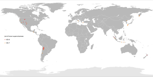
Known super eruptions

Based on incomplete statistics, at least 60 VEI 8 eruptions have been identified. [13] [15]

Well-known VEI 8 eruptions
NameZoneLocationNotesYears ago (approx.)Ejecta bulk volume (approx.)Reference
Youngest Toba eruption Toba Caldera, North Sumatra Sumatra, IndonesiaProduced 439–631 million tons of sulfuric acid 75,0002,000–13,200 km3 [16] [17] [18] [19] [20] [21] [22]
Flat Landing Brook Formation Tetagouche Group New Brunswick, CanadaPossibly the largest known supereruption. Existence as a single eruption is controversial, and it could have been a multiple 2,000+ km3 event that spanned less than a million years466,000,0002,000–12,000 km3 [23] [24]
Wah Wah Springs Caldera Indian Peak–Caliente Caldera Complex Utah, United StatesThe largest of the Indian Peak-Caliente Caldera Complex eruptions, preserved as the Wah Wah Springs Tuff; includes pyroclastic flows more than 500 meters (1,600 ft) thick30,600,0005,500–5,900 km3 [25] [26]
La Garita Caldera San Juan volcanic field Colorado, United States Fish Canyon eruption 27,800,0005,000 km3 [27] [28]
Grey's Landing Supereruption Yellowstone hotspot United StatesDeposited the Grey's Landing Ignimbrite8,720,0002,800 km3 [29]
La Pacana Andes Central Volcanic Zone ChileResponsible for the Antana Ignimbrite4,000,0002,500 km3 [30]
Huckleberry Ridge eruption Yellowstone hotspot Idaho, United StatesHuckleberry Ridge Tuff; consisted of three distinct eruptions separated by years to decades2,100,0002,450–2,500 km3 [31] [32]
Whakamaru Caldera Taupō Volcanic Zone North Island, New ZealandWhakamaru Ignimbrite/Mount Curl Tephra340,0002,000 km3 [33]
Heise Volcanic Field Yellowstone hotspot Idaho, United StatesKilgore Tuff4,500,0001,800 km3 [34]
McMullen Supereruption Yellowstone hotspot Southern Idaho, United StatesMcMullen Ignimbrite8,990,0001,700 km3 [29]
Heise Volcanic Field Yellowstone hotspot Idaho, United StatesBlacktail Tuff6,000,0001,500 km3 [34]
Cerro Guacha Altiplano–Puna volcanic complex Sur Lípez, BoliviaGuacha ignimbrite, two smaller eruptions identified5,700,0001,300 km3 [35]
Mangakino Caldera Taupō Volcanic Zone North Island, New ZealandKidnappers eruption1,080,0001,200 km3 [36]
Oruanui eruption Taupō Volcanic Zone North Island, New Zealand Taupō Volcano (Lake Taupō)26,5001,170 km3 [37]
Galán Andes Central Volcanic Zone Catamarca, ArgentinaConsisted of three distinct eruptions, separated by 30-40 thousand years2,500,0001,050 km3 [38]
Lava Creek eruption Yellowstone hotspot Idaho, Montana, and Wyoming, United States Lava Creek Tuff; consisted of two distinct eruptions separated by years640,0001,000 km3 [31] [32] [26]

Media portrayal

See also

Notes

  1. The term was first used in Conquering the World, a 1925 travelogue by Helen Bridgeman, referring to an Indian Ocean sunset in Indonesia as an upside down "super-volcano". [6]
  2. Subsequent research proved that each peak of the Three Sisters was formed independently, and that Mount Multnomah never existed.[ citation needed ]

Related Research Articles

A caldera is a large cauldron-like hollow that forms shortly after the emptying of a magma chamber in a volcano eruption. An eruption that ejects large volumes of magma over a short period of time can cause significant detriment to the structural integrity of such a chamber, greatly diminishing its capacity to support its own roof, and any substrate or rock resting above. The ground surface then collapses into the emptied or partially emptied magma chamber, leaving a large depression at the surface. Although sometimes described as a crater, the feature is actually a type of sinkhole, as it is formed through subsidence and collapse rather than an explosion or impact. Compared to the thousands of volcanic eruptions that occur over the course of a century, the formation of a caldera is a rare event, occurring only a few times within a given window of 100 years. Only seven caldera-forming collapses are known to have occurred between 1911 and 2016. More recently, a caldera collapse occurred at Kīlauea, Hawaii in 2018.

<span class="mw-page-title-main">Lake Toba</span> Crater lake located in Sumatra, Indonesia

Lake Toba is a large natural lake in North Sumatra, Indonesia, occupying the caldera of a supervolcano. The lake is located in the middle of the northern part of the island of Sumatra, with a surface elevation of about 900 metres (2,953 ft), the lake stretches from 2.88°N 98.52°E to 2.35°N 99.1°E. The lake is about 100 kilometres long, 30 kilometres (19 mi) wide, and up to 505 metres (1,657 ft) deep. It is the largest lake in Indonesia and the largest volcanic lake in the world. Toba Caldera is one of twenty geoparks in Indonesia, and was recognised in July 2020 as one of the UNESCO Global Geoparks.

<span class="mw-page-title-main">Volcano</span> Rupture in a planets crust where material escapes

A volcano is a rupture in the crust of a planetary-mass object, such as Earth, that allows hot lava, volcanic ash, and gases to escape from a magma chamber below the surface.

<span class="mw-page-title-main">Volcanic explosivity index</span> Qualitative scale for explosiveness of volcanic eruptions

The volcanic explosivity index (VEI) is a relative measure of the explosiveness of volcanic eruptions. It was devised by Christopher G. Newhall of the United States Geological Survey and Stephen Self in 1982.

<span class="mw-page-title-main">Toba catastrophe theory</span> Supereruption 74,000 years ago that may have caused a global volcanic winter

The Toba eruption was a supervolcano eruption that occurred around 74,000 years ago during the Late Pleistocene at the site of present-day Lake Toba in Sumatra, Indonesia. It is one of the largest known explosive eruptions in the Earth's history. The Toba catastrophe theory holds that this event caused a severe global volcanic winter of six to ten years and contributed to a 1,000-year-long cooling episode, leading to a genetic bottleneck in humans.

<span class="mw-page-title-main">Yellowstone Caldera</span> Volcanic caldera in Yellowstone National Park in the United states

The Yellowstone Caldera, sometimes referred to as the Yellowstone Supervolcano, is a volcanic caldera and supervolcano in Yellowstone National Park in the Western United States. The caldera and most of the park are located in the northwest corner of Wyoming. The caldera measures 43 by 28 miles, and postcaldera lavas spill out a significant distance beyond the caldera proper.

<span class="mw-page-title-main">Magma chamber</span> Accumulation of molten rock within the Earths crust

A magma chamber is a large pool of liquid rock beneath the surface of the Earth. The molten rock, or magma, in such a chamber is less dense than the surrounding country rock, which produces buoyant forces on the magma that tend to drive it upwards. If the magma finds a path to the surface, then the result will be a volcanic eruption; consequently, many volcanoes are situated over magma chambers. These chambers are hard to detect deep within the Earth, and therefore most of those known are close to the surface, commonly between 1 km and 10 km down.

<span class="mw-page-title-main">Phlegraean Fields</span> Supervolcano located west of Naples, Italy

The Phlegraean Fields is a large volcanic caldera situated to the west of Naples, Italy. It is part of the Campanian volcanic arc, which includes Mount Vesuvius on the east side of Naples. The Phlegraean Fields is monitored by the Vesuvius Observatory. It was declared a regional park in 2003.

<span class="mw-page-title-main">Plinian eruption</span> Type of volcanic eruption

Plinian eruptions or Vesuvian eruptions are volcanic eruptions marked by their similarity to the eruption of Mount Vesuvius in 79 AD, which destroyed the ancient Roman cities of Herculaneum and Pompeii. The eruption was described in a letter written by Pliny the Younger, after the death of his uncle Pliny the Elder.

<span class="mw-page-title-main">Yellowstone hotspot</span> Volcanic hotspot in the United States

The Yellowstone hotspot is a volcanic hotspot in the United States responsible for large scale volcanism in Idaho, Montana, Nevada, Oregon, and Wyoming, formed as the North American tectonic plate moved over it. It formed the eastern Snake River Plain through a succession of caldera-forming eruptions. The resulting calderas include the Island Park Caldera, Henry's Fork Caldera, and the Bruneau-Jarbidge caldera. The hotspot currently lies under the Yellowstone Caldera. The hotspot's most recent caldera-forming supereruption, known as the Lava Creek Eruption, took place 640,000 years ago and created the Lava Creek Tuff, and the most recent Yellowstone Caldera. The Yellowstone hotspot is one of a few volcanic hotspots underlying the North American tectonic plate; another example is the Anahim hotspot.

<span class="mw-page-title-main">Lava Creek Tuff</span> Rock formation in Wyoming, Montana, and Idaho

The Lava Creek Tuff is a voluminous sheet of ash-flow tuff located in Wyoming, Montana and Idaho, United States. It was created during the Lava Creek eruption around 630,000 years ago, which led to the formation of the Yellowstone Caldera. This eruption is considered the climactic event of Yellowstone's third volcanic cycle. The Lava Creek Tuff covers an area of more than 7,500 km2 (2,900 sq mi) centered around the caldera and has an estimated magma volume of 1,000 km3 (240 cu mi).

<span class="mw-page-title-main">La Garita Caldera</span> Large caldera in the state of Colorado, U.S.

La Garita Caldera is a large caldera and extinct supervolcano in the San Juan volcanic field in the San Juan Mountains around the town of Creede in southwestern Colorado, United States. It is west of La Garita, Colorado. The eruption that created the La Garita Caldera is among the largest known volcanic eruptions in Earth's history, as well as being one of the most powerful known supervolcanic events.

<span class="mw-page-title-main">Oruanui eruption</span> Worlds most recent supereruption, of Taupō Volcano, New Zealand

The Oruanui eruption of New Zealand's Taupō Volcano was the world's most recent supereruption, and largest phreatomagmatic eruption characterised to date.

<span class="mw-page-title-main">Timeline of volcanism on Earth</span>

This timeline of volcanism on Earth includes a list of major volcanic eruptions of approximately at least magnitude 6 on the Volcanic explosivity index (VEI) or equivalent sulfur dioxide emission during the Quaternary period. Other volcanic eruptions are also listed.

<span class="mw-page-title-main">La Pacana</span> Large Miocene-age caldera in northern Chile

La Pacana is a Miocene age caldera in northern Chile's Antofagasta Region. Part of the Central Volcanic Zone of the Andes, it is part of the Altiplano-Puna volcanic complex, a major caldera and silicic ignimbrite volcanic field. This volcanic field is located in remote regions at the Zapaleri tripoint between Chile, Bolivia and Argentina.

Vilama is a Miocene caldera in Bolivia and Argentina. Straddling the border between the two countries, it is part of the Central Volcanic Zone, one of the four volcanic belts in the Andes. Vilama is remote and forms part of the Altiplano-Puna volcanic complex, a province of large calderas and associated ignimbrites that were active since about 8 million years ago, sometimes in the form of supervolcanoes.

Wah Wah Springs Caldera is a supervolcanic eruption remnant discovered in 2013 in Utah. It released 5,500 to 5,900 cubic kilometres of tephra, as the Wah Wah Springs Tuff, about 30.06 million years ago in the early Oligocene. It is the largest of the Indian Peak-Caliente Caldera Complex, and includes flows over 500 m thick at the most. It is considered one of the largest single explosive eruptions known in Earth's history, and the second most energetic event to have occurred on Earth since the asteroid impact at the end of the Cretaceous period.

<span class="mw-page-title-main">Whakamaru Caldera</span> A large volcanic caldera in New Zealand

The Whakamaru Caldera was created in a massive supereruption 335,000 years ago and is approximately 30 by 40 km in size and is located in the North Island of New Zealand. It now contains active geothermal areas as well as the later Maroa Caldera.

References

  1. de Silva, Shanaka (2008). "Arc magmatism, calderas, and supervolcanos". Geology. 36 (8): 671. Bibcode:2008Geo....36..671D. doi: 10.1130/focus082008.1 .
  2. "Questions About Supervolcanoes". Volcanic Hazards Program. USGS Yellowstone Volcano Observatory. 21 August 2015. Archived from the original on 3 July 2017. Retrieved 22 August 2017.
  3. Wotzlaw, Jörn-Frederik; Bindeman, Ilya N.; Watts, Kathryn E.; Schmitt, Axel K.; Caricchi, Luca; Schaltegger, Urs (September 2014). "Linking rapid magma reservoir assembly and eruption trigger mechanisms at evolved Yellowstone-type supervolcanoes". Geology. 42 (9): 807–810. Bibcode:2014Geo....42..807W. doi:10.1130/g35979.1. ISSN   1943-2682.
  4. Budd, David A.; Troll, Valentin R.; Deegan, Frances M.; Jolis, Ester M.; Smith, Victoria C.; Whitehouse, Martin J.; Harris, Chris; Freda, Carmela; Hilton, David R.; Halldórsson, Sæmundur A.; Bindeman, Ilya N. (25 January 2017). "Magma reservoir dynamics at Toba caldera, Indonesia, recorded by oxygen isotope zoning in quartz". Scientific Reports. 7 (1): 40624. Bibcode:2017NatSR...740624B. doi:10.1038/srep40624. ISSN   2045-2322. PMC   5264179 . PMID   28120860.
  5. Wilson, C. J. N. (2001). "The 26.5ka Oruanui eruption, New Zealand: An introduction and overview". Journal of Volcanology and Geothermal Research. 112 (1–4): 133–174. Bibcode:2001JVGR..112..133W. doi:10.1016/S0377-0273(01)00239-6.
  6. 1 2 3 Klemetti, Erik (4 October 2013). "The rise of a supervolcano". Wired . Retrieved 29 November 2023.
  7. Harris, Stephen (1988). Fire Mountains of the West: The Cascade and Mono Lake Volcanoes. Missoula, Mountain Press.
  8. supervolcano, n. Oxford English Dictionary, third edition, online version June 2012. Retrieved on 2012-08-17.
  9. Byers Jr., F. M. (May 1949). "Review of The Ancient Volcanoes of Oregon, by H. Williams" . The Journal of Geology. 57 (3): 325 via JSTOR.
  10. "Supervolcanoes". bbc.co.uk. BBC. 3 February 2000. Retrieved 30 November 2023.
  11. USGS Cascades Volcano Observatory Archived 4 February 2012 at the Wayback Machine . Vulcan.wr.usgs.gov. Retrieved on 2011-11-18.
  12. Pearson, V.; Daigneault, R. (January 2009). "An Archean megacaldera complex: The Blake River Group, Abitibi greenstone belt". Precambrian Research. 168 (1–2): 66–82. Bibcode:2009PreR..168...66P. doi:10.1016/j.precamres.2008.03.009.
  13. 1 2 Bryan, S.E. (2010). "The largest volcanic eruptions on Earth" (PDF). Earth-Science Reviews. 102 (3–4): 207–229. Bibcode:2010ESRv..102..207B. doi:10.1016/j.earscirev.2010.07.001.
  14. Keller, G (2014). "Deccan volcanism, the Chicxulub impact, and the end-Cretaceous mass extinction: Coincidence? Cause and effect?". Geological Society of America Special Papers. 505: 57–89. doi:10.1130/2014.2505(03). ISBN   9780813725055.
  15. BG, Mason (2004). "The size and frequency of the largest explosive eruptions on Earth". Bull Volcanol. 66 (8): 735–748. Bibcode:2004BVol...66..735M. doi:10.1007/s00445-004-0355-9. S2CID   129680497.
  16. Petraglia, M.; Korisettar, R.; Boivin, N.; Clarkson, C.; Ditchfield, P.; Jones, S.; Koshy, J.; Lahr, M. M.; et al. (2007). "Middle Paleolithic Assemblages from the Indian Subcontinent Before and After the Toba Super-Eruption". Science. 317 (5834): 114–116. Bibcode:2007Sci...317..114P. doi:10.1126/science.1141564. PMID   17615356. S2CID   20380351.
  17. Knight, M.D., Walker, G.P.L., Ellwood, B.B., and Diehl, J.F. (1986). "Stratigraphy, paleomagnetism, and magnetic fabric of the Toba Tuffs: Constraints on their sources and eruptive styles". Journal of Geophysical Research. 91 (B10): 10355–10382. Bibcode:1986JGR....9110355K. doi:10.1029/JB091iB10p10355.{{cite journal}}: CS1 maint: multiple names: authors list (link)
  18. Ninkovich, D., Sparks, R.S.J., and Ledbetter, M.T. (1978). "The exceptional magnitude and intensity of the Toba eruption, Sumatra: An example of using deep-sea tephra layers as a geological tool". Bulletin Volcanologique. 41 (3): 286–298. Bibcode:1978BVol...41..286N. doi:10.1007/BF02597228. S2CID   128626019.{{cite journal}}: CS1 maint: multiple names: authors list (link)
  19. Rose, W.I. & Chesner, C.A. (1987). "Dispersal of ash in the great Toba eruption, 75 ka" (PDF). Geology. 15 (10): 913–917. Bibcode:1987Geo....15..913R. doi:10.1130/0091-7613(1987)15<913:DOAITG>2.0.CO;2. ISSN   0091-7613. Archived (PDF) from the original on 17 June 2010.
  20. Williams, M.A.J. & Royce, K. (1982). "Quaternary geology of the middle son valley, North Central India: Implications for prehistoric archaeology". Palaeogeography, Palaeoclimatology, Palaeoecology. 38 (3–4): 139. Bibcode:1982PPP....38..139W. doi:10.1016/0031-0182(82)90001-3.
  21. Antonio Costa; Victoria C. Smith; Giovanni Macedonio; Naomi E. Matthews (2014). "The magnitude and impact of the Youngest Toba Tuff super-eruption". Frontiers in Earth Science. 2: 16. Bibcode:2014FrEaS...2...16C. doi: 10.3389/feart.2014.00016 .
  22. Lin, Jiamei; Abbott, Peter M.; Sigl, Michael; Steffensen, Jørgen P.; Mulvaney, Robert; Severi, Mirko; Svensson, Anders (2023). "Bipolar ice-core records constrain possible dates and global radiative forcing following the ~74 ka Toba eruption". Quaternary Science Reviews. 312: 108162. Bibcode:2023QSRv..31208162L. doi: 10.1016/j.quascirev.2023.108162 .
  23. "Lexique du substrat rocheux". dnr-mrn.gnb.ca. Retrieved 22 December 2019.
  24. "A mid-Darriwilian super volcano in northern New Brunswick, rapid climate change and the start of the great Ordovician biodiversification event" (PDF). pp. 118–119. Archived (PDF) from the original on 12 December 2019. Retrieved 11 November 2023.
  25. Tingey, David G.; Hart, Garret L.; Gromme, Sherman; Deino, Alan L.; Christiansen, Eric H.; Best, Myron G. (1 August 2013). "The 36–18 Ma Indian Peak–Caliente ignimbrite field and calderas, southeastern Great Basin, USA: Multicyclic super-eruptions". Geosphere. 9 (4): 864–950. Bibcode:2013Geosp...9..864B. doi: 10.1130/GES00902.1 .
  26. 1 2 King, Hobart M. "Volcanic Explosivity Index: Measuring the size of an eruption". Geology.com.
  27. Ort, Michael (22 September 1997). "La Garita Caldera". Northern Arizona University. Archived from the original on 19 May 2011. Retrieved 5 August 2010.
  28. Lipman, Peter W. (2 November 2007). "Geologic Map of the Central San Juan Caldera Cluster, Southwestern Colorado". USGS Investigations Series I-2799. Archived from the original on 31 August 2010. Retrieved 6 August 2010.{{cite journal}}: Cite journal requires |journal= (help)
  29. 1 2 Knott, Thomas; Branney, M.; Reichow, Marc; Finn, David; Tapster, Simon; Coe, Robert (June 2020). "Discovery of two new super-eruptions from the Yellowstone hotspot track (USA): Is the Yellowstone hotspot waning?". Geology. 48 (9): 934–938. Bibcode:2020Geo....48..934K. doi: 10.1130/G47384.1 . Retrieved 21 June 2022.
  30. Lindsay, J. M. (1 March 2001). "Magmatic Evolution of the La Pacana Caldera System, Central Andes, Chile: Compositional Variation of Two Cogenetic, Large-Volume Felsic Ignimbrites". Journal of Petrology. 42 (3): 459–486. Bibcode:2001JPet...42..459L. doi: 10.1093/petrology/42.3.459 . ISSN   0022-3530.
  31. 1 2 Large Holocene Eruptions. Global Volcanism Program. Archived 13 February 2010 at the Wayback Machine . Volcano.si.edu. Retrieved on 2011-11-18.
  32. 1 2 "What is a supervolcano? What is a supereruption?". USGS.
  33. Froggatt, P. C.; Nelson, C. S.; Carter, L.; Griggs, G.; Black, K. P. (13 February 1986). "An exceptionally large late Quaternary eruption from New Zealand". Nature. 319 (6054): 578–582. Bibcode:1986Natur.319..578F. doi:10.1038/319578a0. S2CID   4332421. The minimum total volume of tephra is 1,200 km3 but probably nearer 2,000 km3, ...
  34. 1 2 Lisa A. Morgan & William C. McIntosh (2005). "Timing and development of the Heise volcanic field, Snake River Plain, Idaho, western USA". GSA Bulletin. 117 (3–4): 288–306. Bibcode:2005GSAB..117..288M. doi:10.1130/B25519.1. S2CID   53648675.
  35. Salisbury, M. J.; Jicha, B. R.; de Silva, S. L.; Singer, B. S.; Jimenez, N. C.; Ort, M. H. (21 December 2010). "40Ar/39Ar chronostratigraphy of Altiplano-Puna volcanic complex ignimbrites reveals the development of a major magmatic province". Geological Society of America Bulletin. 123 (5–6): 821–840. Bibcode:2011GSAB..123..821S. doi:10.1130/B30280.1.
  36. Rejuvenation and Repeated Eruption of a 1.0 Ma Supervolcanic System at Mangakino Caldera, Taupo Volcanic Zone, New Zealand American Geophysical Union, Fall Meeting 2012, abstract #V31C-2797. Retrieved 10 September 2017.
  37. Wilson, C. J. N (1 December 2001). "The 26.5ka Oruanui eruption, New Zealand: an introduction and overview". Journal of Volcanology and Geothermal Research. 112 (1): 133–174. Bibcode:2001JVGR..112..133W. doi:10.1016/S0377-0273(01)00239-6. ISSN   0377-0273.
  38. Kay, Suzanne Mahlburg; Coira, Beatriz; Wörner, Gerhard; Kay, Robert W.; Singer, Bradley S. (1 December 2011). "Geochemical, isotopic and single crystal 40Ar/39Ar age constraints on the evolution of the Cerro Galán ignimbrites". Bulletin of Volcanology. 73 (10): 1487–1511. Bibcode:2011BVol...73.1487K. doi: 10.1007/s00445-010-0410-7 . ISSN   1432-0819.
  39. "Mystery of the Megavolcano" Archived 17 June 2017 at the Wayback Machine . Pbs.org. Accessed on 2017-10-12.

Further reading