Volcanic field

Last updated

The north face of Mount Garibaldi rises above The Table and Garibaldi Lake in the Garibaldi Lake volcanic field MtGaribaldi-NorthFace-TheTable.jpg
The north face of Mount Garibaldi rises above The Table and Garibaldi Lake in the Garibaldi Lake volcanic field

A volcanic field or crater row is an area of Earth's crust that is prone to localized volcanic activity. The type and number of volcanoes required to be called a "field" is not well-defined. [1] Volcanic fields usually consist of clusters of up to 100 volcanoes such as cinder cones. Lava flows may also occur. They may occur as a monogenetic volcanic field or a polygenetic volcanic field.

Contents

Description

Alexander von Humboldt observed in 1823 that geologically young volcanoes are not distributed uniformly across the Earth's surface, but tend to be clustered into specific regions. Young volcanoes are rarely found within cratons, but are characteristic of subduction zones, rift zones, or in ocean basins. Intraplate volcanoes are clustered along hotspot traces. [2]

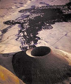
Within regions of volcanic activity, volcanic fields are clusters of volcanoes that share a common magma source. [3] Unlike a large volcano with satellite or subsidiary vents, a volcanic field's vents have their own source of magma, possibly of different compositions (such as basalt and rhyolite), and these vents may span an area of thousands of square miles. [4] Scoria cones are particularly prone to cluster into volcanic fields, which are typically 30–80 kilometers (19–50 mi) in diameter and consist of several tens to several hundred individual cones. The unusually large Trans-Mexican Volcanic Belt has nearly 1000 cones covering an area of 60,000 square kilometers (23,000 sq mi). [5]

Examples

Karapinar Field in Turkey Lake Meke.jpg
Karapınar Field in Turkey
SP Crater in the San Francisco volcanic field is a cinder cone with a basalt lava flow that extends for 4 miles (6 km). SP Crater.jpg
SP Crater in the San Francisco volcanic field is a cinder cone with a basalt lava flow that extends for 4 miles (6 km).
El Muweilih Crater in Sudan with natron-rich clay on the crater floor BVFMuweilihCrater.jpg
El Muweilih Crater in Sudan with natron-rich clay on the crater floor

Canada

Mexico

United States

Iceland

Africa

Others

See also

Related Research Articles

<span class="mw-page-title-main">Volcano</span> Rupture in a planets crust where material escapes

A volcano is a rupture in the crust of a planetary-mass object, such as Earth, that allows hot lava, volcanic ash, and gases to escape from a magma chamber below the surface.

<span class="mw-page-title-main">Stratovolcano</span> Type of conical volcano composed of layers of lava and tephra

A stratovolcano, also known as a composite volcano, is a conical volcano built up by many layers (strata) of hardened lava and tephra. Unlike shield volcanoes, stratovolcanoes are characterized by a steep profile with a summit crater and periodic intervals of explosive eruptions and effusive eruptions, although some have collapsed summit craters called calderas. The lava flowing from stratovolcanoes typically cools and hardens before spreading far, due to high viscosity. The magma forming this lava is often felsic, having high to intermediate levels of silica, with lesser amounts of less viscous mafic magma. Extensive felsic lava flows are uncommon, but have traveled as far as 15 km (9 mi).

<span class="mw-page-title-main">Volcanic cone</span> Landform of ejecta from a volcanic vent piled up in a conical shape

Volcanic cones are among the simplest volcanic landforms. They are built by ejecta from a volcanic vent, piling up around the vent in the shape of a cone with a central crater. Volcanic cones are of different types, depending upon the nature and size of the fragments ejected during the eruption. Types of volcanic cones include stratocones, spatter cones, tuff cones, and cinder cones.

<span class="mw-page-title-main">Indian Heaven</span> Volcanic field in United States of America

Indian Heaven is a volcanic field in Skamania County in the state of Washington, in the United States. Midway between Mount St. Helens and Mount Adams, the field dates from the Pleistocene to the early Holocene epoch. It trends north to south and is dominated by six small shield volcanoes; these shields are topped by small spatter and cinder cones, and the field includes a number of subglacial volcanoes and tuyas. The northernmost peak in the field is Sawtooth Mountain and the southernmost is Red Mountain; its highest point is Lemei Rock at an elevation of 5,925 feet (1,806 m).

A monogenetic volcanic field is a type of volcanic field consisting of a group of small monogenetic volcanoes, each of which erupts only once, as opposed to polygenetic volcanoes, which erupt repeatedly over a period of time. The small monogenetic volcanoes of these fields are the most common subaerial volcanic landform.

<span class="mw-page-title-main">Active volcano</span> Geological feature

An active volcano is a volcano that has erupted during the Holocene, is currently erupting, or has the potential to erupt in the future. A volcano that is not currently erupting but could erupt in the future is known as a dormant volcano. Volcanoes that will not erupt again are known as extinct volcanoes.

<span class="mw-page-title-main">Antofagasta de la Sierra</span> Volcanic field in Argentina

Antofagasta de la Sierra is a volcanic field in Argentina. The main type of volcanic edifice in the area are scoria cones, it is formed by the La Laguna, Jote and Alumbrera volcanoes. The first and last of these form a sub-group which is better researched. Various dating methods have yielded ages from several million to several hundred thousand years ago, but some vents appear to be of Holocene age.

<span class="mw-page-title-main">Peinado</span> Mountain in Argentina

Peinado is a stratovolcano in Catamarca Province, Argentina. It consists of a volcanic cone with a summit crater, surrounded at its foot by lava flows erupted from flank vents. It began erupting about 100,000 years ago, with the last eruption about 36,800 years ago. Future eruptions are possible.

<span class="mw-page-title-main">Rift zone</span> Part of a volcano where a set of linear cracks form

A rift zone is a feature of some volcanoes, especially shield volcanoes, in which a set of linear cracks develops in a volcanic edifice, typically forming into two or three well-defined regions along the flanks of the vent. Believed to be primarily caused by internal and gravitational stresses generated by magma emplacement within and across various regions of the volcano, rift zones allow the intrusion of magmatic dykes into the slopes of the volcano itself. The addition of these magmatic materials usually contributes to the further rifting of the slope, in addition to generating fissure eruptions from those dykes that reach the surface. It is the grouping of these fissures, and the dykes that feed them, that serves to delineate where and whether a rift zone is to be defined. The accumulated lava of repeated eruptions from rift zones along with the endogenous growth created by magma intrusions causes these volcanoes to have an elongated shape. Perhaps the best example of this is Mauna Loa, which in Hawaiian means "long mountain", and which features two very well defined rift zones extending tens of kilometers outward from the central vent.

<span class="mw-page-title-main">Aucanquilcha</span> Stratovolcano in Antofagasta Region, Chile

Aucanquilcha is a massive stratovolcano located in the Antofagasta Region of northern Chile, just west of the border with Bolivia and within the Alto Loa National Reserve. Part of the Central Volcanic Zone of the Andes, the stratovolcano has the form of a ridge with a maximum height of 6,176 metres (20,262 ft). The volcano is embedded in a larger cluster of volcanoes known as the Aucanquilcha cluster. This cluster of volcanoes was formed in stages over eleven million years of activity with varying magma output, including lava domes and lava flows. Aucanquilcha volcano proper is formed from four units that erupted between 1.04–0.23 million years ago. During the ice ages, both the principal Aucanquilcha complex and the other volcanoes of the cluster were subject to glaciation, resulting in the formation of moraines and cirques.

<span class="mw-page-title-main">Cinder cone</span> Steep hill of pyroclastic fragments around a volcanic vent

A cinder cone is a steep conical hill of loose pyroclastic fragments, such as volcanic clinkers, volcanic ash, or scoria that has been built around a volcanic vent. The pyroclastic fragments are formed by explosive eruptions or lava fountains from a single, typically cylindrical, vent. As the gas-charged lava is blown violently into the air, it breaks into small fragments that solidify and fall as either cinders, clinkers, or scoria around the vent to form a cone that often is symmetrical; with slopes between 30 and 40°; and a nearly circular ground plan. Most cinder cones have a bowl-shaped crater at the summit.

<span class="mw-page-title-main">San Pedro (Chile volcano)</span> One of the tallest active volcanoes in the world

San Pedro is a Holocene composite volcano in northern Chile and at 6,155 metres (20,194 ft) in elevation one of the highest active volcanoes in the world. Part of the Chilean Andes' volcanic segment, it is part of the Central Volcanic Zone of the Andes, one of the four tracts of the Andean Volcanic Belt. This region of volcanism includes the world's two highest volcanoes Ojos del Salado and Llullaillaco. San Pedro, like other Andean volcanoes, was formed by the subduction of the Nazca Plate beneath the South America Plate. It has a neighbouring volcano, San Pablo, and is itself formed by two separate edifices usually known as the Old Cone and the Young Cone. These edifices are formed by rocks ranging from basaltic andesite over andesite to dacite and are emplaced on a basement formed by Miocene volcanic rocks.

<span class="mw-page-title-main">Wells Gray-Clearwater volcanic field</span> Volcanic field in British Columbia, Canada

The Wells Gray-Clearwater volcanic field, also called the Clearwater Cone Group, is a potentially active monogenetic volcanic field in east-central British Columbia, Canada, located approximately 130 km (81 mi) north of Kamloops. It is situated in the Cariboo Mountains of the Columbia Mountains and on the Quesnel and Shuswap Highlands. As a monogenetic volcanic field, it is a place with numerous small basaltic volcanoes and extensive lava flows.

<span class="mw-page-title-main">Lava</span> Molten rock expelled by a volcano during an eruption

Lava is molten or partially molten rock (magma) that has been expelled from the interior of a terrestrial planet or a moon onto its surface. Lava may be erupted at a volcano or through a fracture in the crust, on land or underwater, usually at temperatures from 800 to 1,200 °C. The volcanic rock resulting from subsequent cooling is also often called lava.

<span class="mw-page-title-main">Andagua volcanic field</span> Volcanic field in Peru

The Andagua volcanic field is a volcanic field in southern Peru which includes a number of cinder cones, lava domes and lava flows which have filled the Andagua Valley. The volcanic field is part of a larger volcanic province that clusters around the Colca River and is mostly of Pleistocene age, although the Andagua sector also features volcanic cones with historical activity, with the last eruption about 370 years ago. Eruptions were mostly effusive, generating lava flows, cones and small eruption columns. Future eruptions are possible, and there is ongoing fumarolic activity. Volcanic activity in the field has flooded the Andahua valley with lava flows, damming local watersheds in the Laguna de Chachas, Laguna Mamacocha and Laguna Pumajallo lakes and burying the course of the Andagua River. The Andahua valley segment of the larger volcanic province was declared a geopark in 2015.

<span class="mw-page-title-main">El Negrillar</span> Volcanic field in the Andes

El Negrillar is a volcanic field in the Andes. Located south of the Salar de Atacama and west of the Cordón de Púlar, it generated cinder cones and lava flows. Covering a surface area of 220 square kilometres (85 sq mi), it is the largest volcanic field in northern Chile, with almost a hundred vents that produced mainly lava flows. Owing to the arid climate, landforms are well preserved. Radiometric dating has yielded ages of less than 1.5 million years, with the most recent eruption occurring about 141,000 years ago. Parts of the Holocene Socompa debris avalanche overlie the field. A groundwater system underlies the volcanic field and some cones formed through phreatomagmatic eruptions. El Negrillar is located in a complex tectonic regime, characterized by numerous faults. The town of Tilomonte and various power lines, mines and water wells are in the area.

El Toro volcanic field is part of the Central Volcanic Zone of the Andes in the northern Puna of Argentina. Three of the cones in the volcanic field are located southwest of the town of El Toro and the fourth is found north. Part of a field of monogenetic volcanoes associated with subduction of the Nazca Plate beneath the South American Plate, it is constructed from three main cones and an additional lava flow. The field formed between six and two million years ago.

Infiernillo is a volcanic field in Argentina. The field is located northwest of Malargue, at the Rio Salado. The volcanic field, part of the Southern Volcanic Zone, has formed three individual vents with associated lava flows.

<span class="mw-page-title-main">Bayuda volcanic field</span>

Bayuda volcanic field is a volcanic field in Sudan, within the Bayuda Desert. It covers a surface of about 11 by 48 kilometres and consists of a number of cinder cones as well as some maars and explosion craters. These vents have erupted 'A'ā lava flows.

References

  1. Canon-Tapia, E (December 2017). "From 'Volcanic Field' to 'Volcanic Province': A Continuum of Spatial-Clustered Structures With Geological Significance or a Matter of Academic Snobbism?". American Geophysical Union, Fall Meeting 2017, Abstract #V54A-01. 2017. Bibcode:2017AGUFM.V54A..01C. 'Volcanic Field' is a term commonly used to describe a group of small, monogenetic and dominantly basaltic volcanoes, but that often includes groups of mixed monogenetic and polygenetic edifices. Besides ambiguities on the type of edifice that should be considered to form a VF, there is a lack of agreement concerning the number of volcanoes required to define a VF (ranging from five to over 1000), it is uncertain if the area covered by the volcanoes forming a VF must have a minimum number of volcanoes/unit area, or if the distance between adjacent structures needs to have a specific length. Furthermore, in many cases, it is uncertain whether some area is occupied by two adjacent fields or if it is occupied by two subgroups belonging to a unique field.
  2. Schmincke, Hans-Ulrich (2003). Volcanism. Berlin: Springer. pp. 17–19. ISBN   9783540436508.
  3. "Volcanic Fields". Capulin Volcano. National Park Service. Retrieved 27 October 2020.
  4. Ball, Jessica L (31 May 2023). "Having a (volcanic) field day in California". United States Geological Survey . Retrieved 21 July 2023.
  5. Schmincke 2003, p.100