Auckland volcanic field

Last updated

Auckland Volcanic Field
AucklandMapHochstetter1859.JPG
Map of the field drawn by Hochstetter in 1859 and published in English in 1864
Highest point
Elevation 260 m (850 ft)
Coordinates 36°52′37″S174°45′50″E / 36.877°S 174.764°E / -36.877; 174.764
Geography
Auckland volcanic field
Location and extent of the Auckland volcanic field. Clicking on the map enlarges it, and enables panning and mouseover of volcano name/wikilink. Please also see for age and geographical relationships to other North Island surface volcanism
Geology
Age of rock Pleistocene to Meghalayan 0.193–0.0006  Ma [1]
O
S
D
C
P
T
J
K
Pg
N
Mountain type Volcanic field
Type of rock Basalt
Last eruption c. 1400 CE

The Auckland volcanic field is an area of monogenetic volcanoes covered by much of the metropolitan area of Auckland, New Zealand's largest city, located in the North Island. The approximately 53 volcanoes [2] in the field have produced a diverse array of maars (explosion craters), tuff rings, scoria cones, and lava flows. With the exception of Rangitoto, no volcano has erupted more than once, [3] [4] but the other eruptions lasted for various periods ranging from a few weeks to several years. [5] Rangitoto erupted several times [4] and recently twice; in an eruption that occurred about 600 years ago, followed by a second eruption approximately 50 years later. [6] The field is fuelled entirely by basaltic magma, unlike the explosive subduction-driven volcanism in the central North Island, such as at Mount Ruapehu and Lake Taupō. [7]

Contents

Features

The field ranges from Lake Pupuke and Rangitoto Island in the north to Matukutururu (Wiri Mountain) in the south, and from Mount Albert in the west to Pigeon Mountain in the east.

The first vent erupted at Pupuke 193,200 ± 2,800 years ago. [1] The most recent eruption (about 600 years ago [8] and within historical memory of the local Māori) was of Rangitoto, an island shield volcano just east of the city, erupting 0.7 cubic kilometres of lava. The last volcano to erupt was much bigger than all others, with Rangitoto making up 41 per cent of the field's entire volume of erupted material [9] with characteristics as to slope and symmetry around the eruptive vents seen in basaltic shield volcanoes as might be expected in a volcano, that may have buried other volcanoes, and now known to have a 1000-year odd eruptive history. [4] [3] The field's other volcanoes are relatively small, with most less than 150 metres (490 ft) in height.

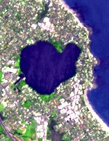
Lake Pupuke, on the North Shore near Takapuna, is a volcanic explosion crater. A few similar craters such as Ōrākei Basin are open to the sea.

The field has produced voluminous lava flows that cover much of the Auckland isthmus. One of the longest runs from Mt Saint John northward, almost crossing the Waitematā Harbour to form Meola Reef. [10] More than 50 lava tubes and other lava caves have been discovered, including the 290-metre (950 ft)-long Wiri Lava Cave. [11] There can be an association with lava caves and the formation of rootless cones due to their mechanism of formation and a rootless cone was suggested to exist at Wiri being Matukutūreia. [12] This may not be quite the case even though at least one steam only driven eruption occurred close to Matukutūreia. [13] The second-longest individual cave in the Auckland field, some 270 metres (890 ft) in total length, is the Cave of a Thousand Press-ups to the east of Maungakiekie/One Tree Hill. [14] Two impressive depressions caused by lava cave collapses are the Puka Street Grotto and the nearby Hochstetter Pond, also known as Grotto Street Pond, in Onehunga. [15] [16]

For most of the 200,000 years that the field has been erupting, the planet has been in glacial periods (ice ages) where sea levels were much lower due to water being locked up as ice, and the Waitemata and Manukau Harbours were dry land. All the volcanoes probably erupted on land except for Rangitoto, which erupted during the current interglacial (warmer) period. [17]

Tectonic relationships

Auckland volcanic field
Map of faults and Quaternary volcanoes in the Auckland region. To show well the volcanoes in relation to fault lines you have to click on the map to enlarge and then zoom and pan. This also enables mouse over of the volcano and fault names. Definite active faults are shown in red. Well characterised inactive fault segments are in dark grey and other faults are shown in grey. A number of faults characterised by sea floor studies off the west coast of North Island are not shown. The type of volcanic eruption (some are composite) is indicated by basalt shield type eruption (black), scoria cone (red), or phreatomagmatic eruptions tuff ring (red-brown) and maar (purple). Volcanoes from both the Auckland volcanic field and South Auckland volcanic field are displayed. Miocene volcanoes are not shown.

The Auckland region lies within the Australian Plate, about 400 kilometres (250 mi) west of its plate boundary with the Pacific Plate. [18] The volcanoes are located south of a geological region called the Northland Allochthon, and with the northern volcanoes located over early Miocene sedimentary deposits of the Waitematā Group of rocks and the southern volcanoes over post Miocene sediments. [18] A large proportion of the volcanoes in the field, particularly those with cone structures, lie within 500 metres (1,600 ft) of inferred or known faults, with the qualification that these are inactive historic faults and unlike in many other volcanic fields it is rare for volcanoes to be actually on the fault line. [19] The structure of these Auckland regional faults and the resulting fault blocks is complex but like the volcanic field their locations can be postulated to be related to gravitational variations and where the Stokes Magnetic Anomaly passes through this section of the North Island. [18] The field is part of the Auckland Volcanic Province which comprises four volcanic fields with intra-plate basaltic volcanism starting in the south, at Okete, near Raglan in late Pliocene times (2.7-1.8 Ma). [20] Activity has since moved north through the Ngatutura, South Auckland and Auckland fields since then. [21]

Human context

Terraces carved by Maori into the slopes of Maungakiekie / One Tree Hill TerracingonOneTreeHill.JPG
Terraces carved by Māori into the slopes of Maungakiekie / One Tree Hill

Mythology

Tāmaki Māori myths describe the creation of the volcanic field as a creation of Mataaho (the guardian of the earth's secrets) and his brother Rūaumoko (the god of earthquakes and volcanoes), made as punishment against a tribe of patupaiarehe, supernatural beings living in the Waitākere Ranges, who used deadly magic from the earth to defeat a war party of patupaiarehe from the Hunua Ranges. [22] [23] In some traditions, the fire goddess Mahuika creates the volcanic field as a way to warm Mataaho, after his wife leaves and takes his clothing. [24] [25] Because of their close association to Mataaho, the volcanic features can be collectively referred to as Nga Maunga a Mataaho ("The Mountains of Mataaho"), [22] or Ngā Huinga-a-Mataaho ("the gathered volcanoes of Mataaho"). [25] Many of the volcanic features of Māngere can be referred to as Nga Tapuwae a Mataoho ("The Sacred Footprints of Mataoho"), including Māngere Lagoon, Waitomokia, Crater Hill, Kohuora, Pukaki Lagoon and Robertson Hill. [24] [26] Many of the Māori language names of volcanic features in the field refer to Mataaho by name, including Te Pane o Mataaho (Māngere Mountain), Te Tapuwae a Mataoho (Robertson Hill) and Te Kapua Kai o Mataoho (the crater of Maungawhau / Mount Eden).

Usage

Many of the maunga (mountains) were occupied by substantial Māori (fortifications) before Pākehā settlement, and many terraces and other archeological remnants are still visible. [27] Many of the cones have been levelled or strongly altered, in small part due to the historical Māori use, but mostly through relatively recent quarrying of construction materials (especially scoria). However many of the remaining volcanoes are now preserved as landmarks and parks. [8]

The warmer northern sides of the mountains were also popular among early Pākehā settlers for housing. [27] In the 1880s, Takarunga / Mount Victoria and Maungauika / North Head were developed as military installations due to fears of a Russian invasion. [27] The cones are also protected by a 1915 law, the Reserves and Other Lands Disposal and Public Bodies Empowering Act 1915, which was passed due to early concern that the distinctive landscape was being eroded, especially by quarrying. While often ignored until the late 20th century, it has amongst other things minimised severe changes to Mount Roskill proposed by Transit New Zealand for the Southwestern Motorway. [28]

In March 2007, New Zealand submitted the volcanic field, with several specifically named features, as a World Heritage Site candidate based on its unique combination of natural and cultural features. [8] At that time, only 2 per cent of more than 800 World Heritage Sites worldwide were in this "mixed" category.

For most of Auckland's post-1840 history, the mountains have been administered variously by the New Zealand Crown, the Auckland Council (or its former bodies including the Auckland City Council and Manukau City Council) or the Department of Conservation. [27]

In the 2014 Treaty of Waitangi settlement between the Crown and the Ngā Mana Whenua o Tāmaki Makaurau collective of 13 Auckland iwi and hapu (also known as the Tāmaki Collective), ownership of the 14 Tūpuna Maunga (ancestral mountains) of Tāmaki Makaurau / Auckland, was vested to the collective. The legislation specified that the land be held in trust "for the common benefit of Ngā Mana Whenua o Tāmaki Makaurau and the other people of Auckland". The Tūpuna Maunga o Tāmaki Makaurau Authority or Tūpuna Maunga Authority (TMA) is the co-governance organisation established to administer the 14 Tūpuna Maunga. Auckland Council manages the Tūpuna Maunga under the direction of the TMA. [27] [29] [30]

Dangers

Since the field is not extinct, new volcanic events may occur at any time, though the usual period between events is, on average, somewhere between hundreds to thousands of years. There has been at least one eruption in every 2,500 years over the last 50,000 years. [20] However, the effects of such an event—especially a full-scale eruption—would be substantial, ranging from pyroclastic surges to earthquakes, [31] lava bombs, ash falls, and the venting volcanic gas, as well as lava flows. These effects might continue for several months, potentially causing substantial destruction and disruption, ranging from the burial of substantial tracts of residential or commercial property, to the mid-to-long-term closures of major parts of the country's infrastructure such as the Port of Auckland, the State Highway network, or the Auckland Airport. [32] It is possible that several volcanoes could erupt simultaneously. There is strong evidence that eight erupted within a span of 3000 years or so, between 31,000 and 28,000 years ago.

Most eruptive events in the field have been small volume, very constrained in time, typically involving less than 0.005 km3 (0.0012 cu mi) of magma making its way to the surface. [20] However the same amount of magma can have an order of magnitude different impact. An underwater eruption which is more likely to be explosive resulted in the formation of the 0.7 km (0.43 mi) wide Ōrākei crater that destroyed an area of 3 km3 (0.72 cu mi) by crater formation and base surge impact. This contrasts with the about 0.5 km (0.31 mi) diameter cone produced by the same amount of upwelling magma that might be expected to destroy an area of 0.3 km3 (0.072 cu mi) if there is no ground water interaction. [20] Modelling has suggested that the next eruption in the volcanic field is likely to be associated with water and in the area extending from the central city to its north and northeast suburbs surrounding and including the Waitemata Harbour. [33] Within New Zealand the volcanic hazard of the field is graded below that of Taupo Volcanic Zone volcano's but is likely to be perceived by the population affected as a greater potential nuisance if it occurs [34]

Various operative structures, plans and systems have been set up to prepare responses to volcanic activity within the urban areas, mainly coordinated in the Auckland Volcanic Field Contingency Plan [32] of the Auckland Regional Council, which provides a framework for interaction of civil defence and emergency services during an eruption. Auckland also has a seismic monitoring network comprising six seismometers—including one 250 metres (820 ft) deep at Riverhead—and three repeaters within the region that will detect the small tremors likely to precede any volcanic activity. [35] This is likely to give between a few hours and several days' warning of an impending eruption, and its approximate location. [31]

Auckland War Memorial Museum, itself built on the crater rim of Pukekawa, has an exhibition on the field, including the "Puia Street multi-sensory visitor experience", which simulates a grandstand view of an eruption in Auckland. [36]

List of volcanoes

The volcanoes within the field are: [5] [37] [38]

VolcanoesAge (thousand years) [39] HeightLocation (Coordinates)RefsImages
Albert Park Volcano 145.0 ± 4.0Unclear 36°50′55″S174°46′02″E / 36.8486°S 174.7673°E / -36.8486; 174.7673 [40]
Albert Park Volcano surrounded by city buildings Albert Park From Lumley Centre Building.jpg
Albert Park Volcano surrounded by city buildings
Ash Hill 31.8 ± 0.430 metres (98 ft) 37°00′10″S174°52′03″E / 37.002754°S 174.867545°E / -37.002754; 174.867545
Boggust Park Crater 130+14 metres (46 ft) 36°57′19″S174°48′49″E / 36.955413°S 174.813552°E / -36.955413; 174.813552 [2]
Oblique aerial view of Boggust Park explosion crater from the north, 2018. Boggust Park Volcano, 2018.jpg
Oblique aerial view of Boggust Park explosion crater from the north, 2018.
Cemetery Crater Undated33 metres (108 ft) 36°59′23″S174°50′28″E / 36.989828°S 174.841082°E / -36.989828; 174.841082 [2]
Site of Cemetery Crater beneath houses in 2018. Cemetery Crater 2018.jpg
Site of Cemetery Crater beneath houses in 2018.
Crater Hill 30.4 ± 0.8 36°59′12″S174°49′38″E / 36.986546°S 174.827135°E / -36.986546; 174.827135
Crater Hill volcano in 2009 Crater Hill 2009.jpg
Crater Hill volcano in 2009
Crater Hill volcano Crater hill volcano Auckland.jpg
Crater Hill volcano
Grafton Volcano 106.582 metres (269 ft) 36°51′30″S174°45′49″E / 36.858440°S 174.763624°E / -36.858440; 174.763624
Site of Grafton explosion crater and tuff ring in 2018, completely covered in houses and medical School except for Outhwaite Park Grafton Volcano 2018 (3).jpg
Site of Grafton explosion crater and tuff ring in 2018, completely covered in houses and medical School except for Outhwaite Park
Hampton Park 57.0 ± 32.043 metres (141 ft) 36°57′03″S174°53′44″E / 36.950925°S 174.89544°E / -36.950925; 174.89544
Hampton Park Volcano from north, 2009 Hampton Park 2009.jpg
Hampton Park Volcano from north, 2009
Kohuora 33.7 ± 2.437 metres (121 ft) 36°58′43″S174°50′34″E / 36.97873°S 174.842691°E / -36.97873; 174.842691
Kohuora Explosion Crater from northwest, 2009 Kohuora Explosion Crater 2009.jpg
Kohuora Explosion Crater from northwest, 2009
Māngere Lagoon 59.520 metres (66 ft) 36°57′25″S174°46′39″E / 36.95702°S 174.77763°E / -36.95702; 174.77763
Mangere Lagoon MangereLagoon.2.jpg
Māngere Lagoon
Matanginui / Green Mount 19.6 ± 6.678 metres (256 ft) 36°56′24″S174°53′54″E / 36.939911°S 174.898267°E / -36.939911; 174.898267
Rubbish heap replaces quarried away Matanginui / Green Mountain, 2009 Green Mt 2009.jpg
Rubbish heap replaces quarried away Matanginui / Green Mountain, 2009
Matukutūreia / McLaughlins Mountain48.0 ± 3.073 metres (240 ft) 37°00′49″S174°50′46″E / 37.013511°S 174.845974°E / -37.013511; 174.845974 [13]
Matukutureia / McLaughlins Mt, 2018 McLaughlin Mt 2018.jpg
Matukutureia / McLaughlins Mt, 2018
Maungakiekie / One Tree Hill 67.0 ± 12.0182 metres (597 ft) 36°54′0″S174°46′59″E / 36.90000°S 174.78306°E / -36.90000; 174.78306
Maungakiekie / One Tree Hill from the northwest, 2018 One Tree Hill 2018.jpg
Maungakiekie / One Tree Hill from the northwest, 2018
Maungakiekie / One Tree Hill and its obelisk One Tree Hill, Auckland.jpg
Maungakiekie / One Tree Hill and its obelisk
Maungarahiri / Little Rangitoto 24.6 ± 0.675 metres (246 ft) 36°52′31″S174°48′35″E / 36.875407°S 174.809636°E / -36.875407; 174.809636
Maungarahiri / Little Rangitoto from the north over Benson Rd shops, 2019 Little Rangitoto 2019.jpg
Maungarahiri / Little Rangitoto from the north over Benson Rd shops, 2019
Maungarei / Mount Wellington10.0 ± 1.0135 metres (443 ft) 36°53′35″S174°50′47.6″E / 36.89306°S 174.846556°E / -36.89306; 174.846556
Maungarei / Mount Wellington, 2018 Mt Wellington 2018.jpg
Maungarei / Mount Wellington, 2018
Maungarei / Mount Wellington from the quarried remnants of Te Tauoma Purchas Hill remnant.jpg
Maungarei / Mount Wellington from the quarried remnants of Te Tauoma
Maungataketake / Elletts Mountain88.9 ± 4.876 metres (249 ft) 36°59′41″S174°44′51″E / 36.994635°S 174.747548°E / -36.994635; 174.747548
Quarried out site of Maungataketake Volcano, 2018 Maungataketake 2018.jpg
Quarried out site of Maungataketake Volcano, 2018
Maungauika / North Head 87.5 ± 15.250 metres (160 ft) 36°49′40″S174°48′43″E / 36.827751°S 174.81205°E / -36.827751; 174.81205
Maungauika / North Head Volcano, 2018 North Head 2018.jpg
Maungauika / North Head Volcano, 2018
Maungauika / North Head (center) and Takarunga / Mount Victoria (left) scoria cones North Head North Shore City.jpg
Maungauika / North Head (center) and Takarunga / Mount Victoria (left) scoria cones
Maungawhau / Mount Eden 28.0 ± 0.6196 metres (643 ft) 36°52′37″S174°45′50″E / 36.877°S 174.764°E / -36.877; 174.764
Maungawhau / Mount Eden, 2018 Mt Eden 2018.jpg
Maungawhau / Mount Eden, 2018
Crater of Maungawhau / Mount Eden Mount Eden Crater Hollow Auckland.jpg
Crater of Maungawhau / Mount Eden
Motukorea / Browns Island 24.4 ± 0.668 metres (223 ft) 36°49′50″S174°53′41″E / 36.8306°S 174.8948°E / -36.8306; 174.8948
Motukorea / Browns Island, 2009 Motukorea 2009.jpg
Motukorea / Browns Island, 2009
Motukorea / Browns Island Browns Island01.jpg
Motukorea / Browns Island
Mount Robertson / Sturges Park 24.3 ± 0.878 metres (256 ft) 36°56′55″S174°50′30″E / 36.948477°S 174.841726°E / -36.948477; 174.841726
Mount Robertson / Sturges Park from the north, 2018 Sturges Park 2018.jpg
Mount Robertson / Sturges Park from the north, 2018
Ōhinerau / Mount Hobson 34.2 ± 1.8143 metres (469 ft) 36°52′40″S174°47′10″E / 36.877814°S 174.786156°E / -36.877814; 174.786156
Ohinerau / Mount Hobson Epsom Girls' Grammar School and Ohinerau Mount Hobson.jpg
Ōhinerau / Mount Hobson
Ohuiarangi / Pigeon Mountain 23.4 ± 0.855 metres (180 ft) 36°53′20″S174°54′11″E / 36.888846°S 174.903116°E / -36.888846; 174.903116
Ohuiarangi / Pigeon Mt, 2009 Pigeon Mt.jpg
Ohuiarangi / Pigeon Mt, 2009
Ōrākei Basin 126.0 ± 6.054 metres (177 ft) 36°52′02″S174°48′47″E / 36.867124°S 174.81308°E / -36.867124; 174.81308
Orakei Basin, 2018 Orakei Basin 2018.jpg
Ōrākei Basin, 2018
Ōtāhuhu / Mount Richmond 30.2 ± 4.250 metres (160 ft) 36°55′57″S174°50′22″E / 36.932562°S 174.839451°E / -36.932562; 174.839451
Otahuhu / Mt Richmond, 2018 Mt Richmond 2018.jpg
Ōtāhuhu / Mt Richmond, 2018
Ōtuataua 24.2 ± 1.864 metres (210 ft) 36°59′10″S174°45′15″E / 36.98611°S 174.75417°E / -36.98611; 174.75417
Otuataua volcanic cone and lava flow field Otuataua 2009.jpg
Ōtuataua volcanic cone and lava flow field
Ōwairaka / Te Ahi-kā-a-Rakataura / Mount Albert 119.2 ± 5.6135 metres (443 ft) 36°53′26″S174°43′12″E / 36.890475°S 174.720097°E / -36.890475; 174.720097
Owairaka / Mt Albert, 2009 Mt Albert 2009.jpg
Ōwairaka / Mt Albert, 2009
Puhinui Craters Undated24 metres (79 ft) 37°00′53″S174°49′59″E / 37.01465°S 174.83296°E / -37.01465; 174.83296 [2]
Puhinui Craters, 2018 Puhinui Craters 2018.jpg
Puhinui Craters, 2018
Pukaki Lagoon 45+37 metres (121 ft) 36°58′59″S174°48′37″E / 36.982998°S 174.810226°E / -36.982998; 174.810226
Pukaki explosion crater and tuff ring, 2018 Pukaki Lagoon 2018.jpg
Pukaki explosion crater and tuff ring, 2018
Pukaki maar PukakiLagoon.1.jpg
Pukaki maar
Pukeiti 23.730 metres (98 ft) 36°59′02″S174°45′26″E / 36.983756°S 174.757183°E / -36.983756; 174.757183
Pukeiti volcano, 2009 Pukeiti 2009.jpg
Pukeiti volcano, 2009
Pukekawa / Auckland Domain 106.0 ± 8.077 metres (253 ft) 36°51′33″S174°46′33″E / 36.859158°S 174.775808°E / -36.859158; 174.775808
Pukekawa / Auckland Domain, 2018 Domain Volcano 2018.jpg
Pukekawa / Auckland Domain, 2018
Sports grounds within Pukekawa volcano Auckland Domain, Nueva Zelanda - panoramio (2).jpg
Sports grounds within Pukekawa volcano
Pukewīwī / Puketāpapa / Mount Roskill105.3 ± 6.2110 metres (360 ft) 36°54′44″S174°44′15″E / 36.912286°S 174.737371°E / -36.912286; 174.737371
Pukewiwi / Puketapapa / Mt Roskill, 2018 Mt Roskill 2018.jpg
Pukewīwī / Puketāpapa / Mt Roskill, 2018
Pukewairiki 130+35 metres (115 ft) 36°56′39″S174°51′57″E / 36.944078°S 174.865887°E / -36.944078; 174.865887
Pukewairiki explosion crater and tuff ring, 2009 Pukewairiki 2009.jpg
Pukewairiki explosion crater and tuff ring, 2009
Pupuke 193.2 ± 5.634 metres (112 ft) 36°46′48″S174°45′58″E / 36.780115°S 174.766184°E / -36.780115; 174.766184
Pupuke crater from space in 2006 Lake Pupuke - satellite photo.jpg
Pupuke crater from space in 2006
Rangitoto Island 0.62 (first eruption)260 metres (850 ft) 36°47′12″S174°51′36″E / 36.786742°S 174.860115°E / -36.786742; 174.860115
Rangitoto Island on the horizon Rangitoto from Achilles Point.jpg
Rangitoto Island on the horizon
Rarotonga / Mount Smart 20.1 ± 0.287 metres (285 ft) (quarried) 36°55′6″S174°48′45″E / 36.91833°S 174.81250°E / -36.91833; 174.81250
The quarried out cone of Rarotonga / Mt Smart is now Mt Smart Stadium, 2018 Mt Smart 2009.jpg
The quarried out cone of Rarotonga / Mt Smart is now Mt Smart Stadium, 2018
Styaks Swamp 19.116 metres (52 ft) 36°56′10″S174°54′01″E / 36.936138°S 174.900155°E / -36.936138; 174.900155
Site of Styaks Swamp buried beneath buildings and road, 2009 Styaks Swamp 2009.jpg
Site of Styaks Swamp buried beneath buildings and road, 2009
Takaroro / Mount Cambria 42.3 ± 22.030 metres (98 ft) (quarried) 36°49′28″S174°48′07″E / 36.824444°S 174.801933°E / -36.824444; 174.801933
Site of quarried away Takaroro / Mt Cambria, 2018 Mt Cambria 2018.jpg
Site of quarried away Takaroro / Mt Cambria, 2018
Takarunga / Mount Victoria 34.8 ± 4.087 metres (285 ft) 36°49′36″S174°47′56″E / 36.8266°S 174.7990°E / -36.8266; 174.7990
Takarunga / Mount Victoria, 2018 Mt Victoria 2018.jpg
Takarunga / Mount Victoria, 2018
Taurere / Taylors Hill 30.2 ± 0.256 metres (184 ft) 36°51′51″S174°52′12″E / 36.864223°S 174.869943°E / -36.864223; 174.869943
Taurere / Taylors Hill, 1994 Taylors Hill 1994.jpg
Taurere / Taylors Hill, 1994
Te Apunga-o-Tainui / McLennan Hills 41.3 ± 2.445 metres (148 ft) (quarried) 36°55′45″S174°50′47″E / 36.929208°S 174.846468°E / -36.929208; 174.846468
Te Apunga-o-Tainui / McLennan Hills, Painting by G.H. Cooper, 1861, Auckland Art Gallery Military encampment at Mount Richmond (1861).jpg
Te Apunga-o-Tainui / McLennan Hills, Painting by G.H. Cooper, 1861, Auckland Art Gallery
Te Hopua-a-Rangi / Gloucester Park 31.012 metres (39 ft) 36°55′46″S174°47′05″E / 36.9295°S 174.784734°E / -36.9295; 174.784734
Te Hopua, 2018 Te Hopua 2018.jpg
Te Hopua, 2018
Te Kopua Kai-a-Hiku / Panmure Basin 25.2 ± 1.835 metres (115 ft) 36°54′18″S174°50′58″E / 36.90495°S 174.849343°E / -36.90495; 174.849343 [41]
Panmure Basin, 2009 Panmure Basin 2009.jpg
Panmure Basin, 2009
Te Kopua Kai-a-Hiku / Panmure Basin with Maungarei / Mount Wellington behind Lagoon Drive Walking Pathway.jpg
Te Kopua Kai-a-Hiku / Panmure Basin with Maungarei / Mount Wellington behind
Te Kopua-o-Matakamokamo / Tank Farm / Tuff Crater 181.0 ± 2.046 metres (151 ft) 36°48′07″S174°45′12″E / 36.8020°S 174.7533°E / -36.8020; 174.7533
Te Kopua-o-Matokamokamo / Tank Farm, 2009 Tank Farm 2009.jpg
Te Kopua-o-Matokamokamo / Tank Farm, 2009
Onepoto 187.646 metres (151 ft) 36°48′29″S174°45′03″E / 36.80818°S 174.75085°E / -36.80818; 174.75085
Onepoto explosion crater and tuff ring, 2009 Onepoto 2009.jpg
Onepoto explosion crater and tuff ring, 2009
Te Kōpuke / Tītīkōpuke / Mount St John 75.3 ± 3.4126 metres (413 ft) 36°53′00″S174°46′49″E / 36.883431°S 174.780196°E / -36.883431; 174.780196
Te Kopuke / Titikopuke / Mount St John, 2009 Mt St John 2009.jpg
Te Kōpuke / Tītīkōpuke / Mount St John, 2009
Crater of Te Kopuke / Titikopuke / Mount St John MtStJohnCrater.1.jpg
Crater of Te Kōpuke / Tītīkōpuke / Mount St John
Te Motu-a-Hiaroa / Puketutu 29.8 ± 4.465 metres (213 ft) 36°57′55″S174°44′50″E / 36.965186°S 174.747248°E / -36.965186; 174.747248
Te Motu-a-Hiaroa / Puketutu Island Volcano, 2918 Puketutu 2018.jpg
Te Motu-a-Hiaroa / Puketutu Island Volcano, 2918
Te Pane-o-Mataaho / Māngere Mountain 59.0 ± 20.0106 metres (348 ft) 36°56′59″S174°46′59″E / 36.9496°S 174.7831°E / -36.9496; 174.7831 [42]
Te Pane-o-Mataaho / Mangere Mountain, 2009 Mangere Mt 2009.jpg
Te Pane-o-Mataaho / Māngere Mountain, 2009
Te Pane-o-Mataaho / Mangere Mountain from the east Mt Mangere,Auckland.NZ (11334561603).jpg
Te Pane-o-Mataaho / Māngere Mountain from the east
Te Pou Hawaiki 28.0+95 metres (312 ft) (quarried) 36°52′57″S174°46′00″E / 36.88247°S 174.766726°E / -36.88247; 174.766726
Site of Te Pou Hawaiki is now a three-storey concrete carpark building, 2018 Te Pou Hawaiki 2018x.jpg
Site of Te Pou Hawaiki is now a three-storey concrete carpark building, 2018
Te Puke ō Tara / Otara Hill 56.589 metres (292 ft) (quarried) 36°56′50″S174°53′54″E / 36.947105°S 174.898363°E / -36.947105; 174.898363
The buildings in the middle of the photo are on the site of quarried away Te Puke o Tara / Otara Hill volcano, 2009 Otara Hill 2009.jpg
The buildings in the middle of the photo are on the site of quarried away Te Puke ō Tara / Otara Hill volcano, 2009
Te Tātua-a-Riukiuta / Three Kings 31.0 ± 1.8133 metres (436 ft) 36°54′11″S174°45′17″E / 36.902926°S 174.754651°E / -36.902926; 174.754651
The entire crater and tuff ring of Te Tatua-a-Riukiuta / Three Kings Three Kings 2018.jpg
The entire crater and tuff ring of Te Tātua-a-Riukiuta / Three Kings
Quarrying has removed two of the Tatua-a-Riukiuta / Three Kings Three Kings Quarry Scenery Views I.jpg
Quarrying has removed two of the Tātua-a-Riukiuta / Three Kings
Te Tauoma / Purchas Hill 10.9 ± 0.250 metres (160 ft) (quarried) 36°53′14″S174°50′51″E / 36.887138°S 174.847476°E / -36.887138; 174.847476
The site of Te Tauoma / Purchas Hill, 2018 Purchas Hill 2018.jpg
The site of Te Tauoma / Purchas Hill, 2018
Waitomokia / Mt Gabriel20.3 ± 0.222 metres (72 ft) (quarried) 36°58′37″S174°46′13″E / 36.976981°S 174.770336°E / -36.976981; 174.770336
Waitomokia explosion crater and tuff ring, 2018 Waitomokia 2018.jpg
Waitomokia explosion crater and tuff ring, 2018
Whakamuhu / Saint Heliers / Glover Park – see Achilles Point 161.0 ± 36.065 metres (213 ft) 36°50′49″S174°52′04″E / 36.846911°S 174.867662°E / -36.846911; 174.867662
Whakamuhu / St Heliers Volcano, 2009 St Heliers 2009.jpg
Whakamuhu / St Heliers Volcano, 2009
The Glover Park sports ground at lower right of this photo is situated within the Whakamuhu tuff ring. Over the water in the distance on the right is the scoria cone of Maungauika / North Head and in the left middle is the tuff crater filled in by the sea of Orakei Basin. Beyond Orakei Basin in the middle distance are several vegetation covered scoria cones. Eastern Beaches Of Auckland City.jpg
The Glover Park sports ground at lower right of this photo is situated within the Whakamuhu tuff ring. Over the water in the distance on the right is the scoria cone of Maungauika / North Head and in the left middle is the tuff crater filled in by the sea of Ōrākei Basin. Beyond Ōrākei Basin in the middle distance are several vegetation covered scoria cones.
Wiri Mountain / Matukutūruru 30.1–31.080 metres (260 ft) (quarried) 37°00′26″S174°51′30″E / 37.007334°S 174.858441°E / -37.007334; 174.858441
Site of quarried away Matukutururu / Wiri Mt, 2018 Wiri Mt 2018.jpg
Site of quarried away Matukutururu / Wiri Mt, 2018

See also

Related Research Articles

<span class="mw-page-title-main">Rangitoto Island</span> Island in New Zealand

Rangitoto Island is a volcanic island in the Hauraki Gulf near Auckland, New Zealand. The 5.5 km (3.4 mi) wide island is a symmetrical shield volcano cone capped by central scoria cones, reaching a height of 260 m (850 ft). Rangitoto is the youngest and largest of the approximately 50 volcanoes of the Auckland volcanic field, having erupted in two phases about 1450 CE and 1500 CE and covering an area of 2,311 ha. It is separated from the mainland of Auckland's North Shore by the Rangitoto Channel. Since World War II, it has been linked by a causeway to the much older, non-volcanic Motutapu Island.

<span class="mw-page-title-main">Maungakiekie / One Tree Hill</span> Hill in Auckland, New Zealand

Maungakiekie / One Tree Hill is a 182-metre (597 ft) volcanic peak and Tūpuna Maunga in Auckland, New Zealand. It is an important place culturally and archeologically for both Māori and Pākehā. The suburb around the base of the hill is also called One Tree Hill. It is surrounded by the suburbs of Royal Oak to the west, and clockwise, Epsom, Greenlane, Oranga, and Onehunga. The summit provides views across the Auckland area, and allows visitors to see both of Auckland's harbours.

<span class="mw-page-title-main">Mount Victoria (Auckland)</span> Scoria cone in Auckland, New Zealand

Takarunga / Mount Victoria is the highest volcano on Auckland's North Shore, rising to 66 metres in elevation. Its age is currently unknown. Its lava flows now line much of Devonport's waterfront. Takarunga was the location of an important pā used by Tāmaki Māori peoples. In the late 19th century, a gun fort was built on top of the hill, in order to defend the city of Auckland. As a designated tūpuna maunga, the mountain has been governed by the Tūpuna Maunga Authority, along with thirteen other cones throughout Auckland, since 2014.

<span class="mw-page-title-main">Māngere Mountain</span> Volcanic cone in Auckland, New Zealand

Māngere Mountain, also known by the names Te Pane-o-Mataaho and Te Ara Pueru, is a volcanic cone in Māngere, Auckland. Located within Māngere Domain, it is one of the largest volcanic cones in the Auckland volcanic field, with a peak 106 metres (348 ft) above sea level. It was the site of a major pā and many of the pā's earthworks are still visible. It has extensive panoramic views of Auckland from its location in the southeastern portion of the city's urban area.

<span class="mw-page-title-main">North Head (New Zealand)</span> Scoria cone in Auckland, New Zealand

North Head is a volcano and Tūpuna Maunga forming a headland at the east end of the Waitematā Harbour in Auckland, New Zealand, in the suburb of Devonport. Known for its sweeping views over the harbour and the Hauraki Gulf, since 1885 the head was mainly used by the military as a coastal defence installation, which left a network of accessible old bunkers and tunnels as its legacy, forming part of the attraction. The site was protected as part of Hauraki Gulf Maritime Park in 1972 and listed as a Category I historic place in 2001. As part of a 2014 Treaty of Waitangi claim settlement the volcanic cone was officially named Maungauika and the reserve unofficially renamed Maungauika / North Head Historic Reserve.

<span class="mw-page-title-main">Ōhinerau / Mount Hobson</span> Scoria cone in Auckland, New Zealand

Ōhinerau / Mount Hobson is a 143 m high volcanic cone and Tūpuna Maunga in the Auckland volcanic field in Auckland, New Zealand.

<span class="mw-page-title-main">Pigeon Mountain (New Zealand)</span> Hill in New Zealand

Pigeon Mountain is a 58 m (190 ft) high volcanic cone and Tūpuna Maunga at Half Moon Bay, near Howick and Bucklands Beach, in Auckland, New Zealand. It is part of the Auckland volcanic field.

<span class="mw-page-title-main">Achilles Point</span>

Achilles Point is a rocky point on the headland at the eastern end of the small sandy beach named Ladies Bay, Auckland, New Zealand. The name 'Te Pane o Horoiwi' can also sometimes refer to the whole headland between St Heliers and Tamaki River estuary. Achilles Point is named after a ship called HMNZS Achilles (70) which defeated the German pocket battleship Admiral Graf Spee in 1939. The headland, from the point round to the Tamaki heads, was previously known as Te Pane o Horoiwi, named after Horoiwi who arrived in New Zealand on the Tainui canoe (waka).

<span class="mw-page-title-main">Mount Smart</span> Hill in New Zealand

Mount Smart is one of the volcanoes and Tūpuna Maunga in the Auckland volcanic field. A century of quarrying removed almost all the 87 meter scoria cone along with extensive terracing excavated by Māori. The former quarry is now the site of Mount Smart Stadium.

<span class="mw-page-title-main">Geology of the Auckland Region</span>

The Auckland Region of New Zealand is built on a basement of greywacke rocks that form many of the islands in the Hauraki Gulf, the Hunua Ranges, and land south of Port Waikato. The Waitākere Ranges in the west are the remains of a large andesitic volcano, and Great Barrier Island was formed by the northern end of the Coromandel Volcanic Zone. The Auckland isthmus and North Shore are composed of Waitemata sandstone and mudstone, and portions of the Northland Allochthon extend as far south as Albany. Little Barrier Island was formed by a relatively isolated andesitic volcano, active around 1 to 3 million years ago.

<span class="mw-page-title-main">Crater Hill</span>

Crater Hill is one of the volcanoes of the Auckland volcanic field, in New Zealand. It consists of an explosion crater about 600 metres (2,000 ft) wide, partly filled with water. The hill, alongside Māngere Lagoon, Waitomokia, Kohuora, Pukaki Lagoon and Robertson Hill, is one of the volcanic features collectively referred to as Nga Tapuwae a Mataoho, referring to the deity in Tāmaki Māori myths who was involved in their creation.

<span class="mw-page-title-main">Matukutūruru</span> Scoria hill in Auckland, New Zealand

Matukutūruru is a volcano and Tūpuna Maunga in Wiri, in the Auckland volcanic field. It had a scoria cone reaching 80 metres above sea level, which was quarried away. The lava flows created 290m long Wiri Lava Cave. The hill was the site of a pā. In late 2011 the quarry lake was drained and fill-dumping began on the site.

<span class="mw-page-title-main">Ōtāhuhu / Mount Richmond</span> Hill in Auckland, New Zealand

Ōtāhuhu / Mount Richmond is volcanic peak and Tūpuna Maunga in the Auckland volcanic field. A group of scoria mounds up to 48 m high, it has two 50 m wide craters. It was the site of a pā, and retains some Māori earthworks from that time such as kumara pits and terracing.

<span class="mw-page-title-main">Mount Saint John (New Zealand)</span> Scoria cone in Auckland, New Zealand

Mount Saint John, is a volcanic scoria cone and Tūpuna Maunga in Epsom, in the Auckland volcanic field of New Zealand.

<span class="mw-page-title-main">Ōwairaka / Mount Albert</span> Scoria cone in Auckland, New Zealand

Ōwairaka / Mount Albert, also known as Te Ahi-kā-a-Rakataura, is a volcanic peak and Tūpuna Maunga which dominates the landscape of the Ōwairaka and Mount Albert suburbs of Auckland.

<span class="mw-page-title-main">Maungawhau / Mount Eden</span> Scoria cone in Auckland, New Zealand

Maungawhau / Mount Eden is a scoria cone and Tūpuna Maunga in the Mount Eden suburb of Auckland, New Zealand. The cone is part of the Auckland volcanic field, the tallest located on the isthmus.

<span class="mw-page-title-main">Maungarei</span> Scoria cone in Auckland, New Zealand

Mount Wellington / Maungarei is a 135-metre volcanic peak and Tūpuna Maunga located in the Auckland volcanic field of Auckland, New Zealand. It is the youngest onshore volcano of the Auckland volcanic field, having been formed by an eruption around 10,000 years ago. It is the largest of Auckland's scoria cones and has a near-circular base with a flattish rim and three small craters. It is situated in the Mount Wellington suburb of East Auckland.

<span class="mw-page-title-main">Te Tātua a Riukiuta</span> Scoria cone in Auckland, New Zealand

Te Tātua a Riukiuta / Big King is a volcano and Tūpuna Maunga in Three Kings, New Zealand that erupted 28,500 years ago. The volcano had three prominent peaks known as Three Kings and a number of smaller peaks until most of them were quarried away, leaving a sole remaining large peak known as Big King.

Mataaho is a Māori deity. Variously considered a god of earthquakes and eruptions, the guardian of the earth's secrets, the god of volcanic forces, or a giant, Mataaho is associated with many of the volcanic features in the Tāmaki Makaurau Region. In traditional Tāmaki Māori myths, Mataaho either creates the volcanic features of the landscape, or requests the gods to create them. Mataaho holds traditional significance for Te Kawerau ā Maki and Waiohua iwi, and is considered a tupuna (ancestor) of Te Ākitai Waiohua iwi.

<span class="mw-page-title-main">Tūpuna Maunga o Tāmaki Makaurau</span> Mountains in Auckland, New Zealand

The Tūpuna Maungao Tāmaki Makaurau are 14 volcanic cones that hold great historical, spiritual, ancestral and cultural significance to the 13 Māori iwi and hapū of Ngā Mana Whenua o Tāmaki Makaurau, who have owned them since 2014.

References

  1. 1 2 Leonard, Graham S.; Calvert, Andrew T.; Hopkins, Jenni L.; Wilson, Colin J. N.; Smid, Elaine R.; Lindsay, Jan M.; Champion, Duane E. (1 September 2017). "High-precision 40Ar/39Ar dating of Quaternary basalts from Auckland Volcanic Field, New Zealand, with implications for eruption rates and paleomagnetic correlations". Journal of Volcanology and Geothermal Research. 343: 60–74. Bibcode:2017JVGR..343...60L. doi:10.1016/j.jvolgeores.2017.05.033. ISSN   0377-0273.
  2. 1 2 3 4 Hayward, Bruce W.; Kenny, Jill A.; Grenfell, Hugh R. (2011). "More volcanoes recognised in Auckland Volcanic Field". Geoscience Society of New Zealand Newsletter (5): 11–16. Retrieved 19 April 2013.
  3. 1 2 Shane, Phil; Gehrels, Maria; Zawalna-Geer, Aleksandra; Augustinus, Paul; Lindsay, Jan; Chaillou, Isabelle (2013). "Longevity of a small shield volcano revealed by crypto-tephra studies (Rangitoto volcano, New Zealand): Change in eruptive behavior of a basaltic field". Journal of Volcanology and Geothermal Research. 257: 174–183. Bibcode:2013JVGR..257..174S. doi:10.1016/j.jvolgeores.2013.03.026. ISSN   0377-0273.
  4. 1 2 3 Linnell, Tamzin; et al. (2016). "Long-lived shield volcanism within a monogenetic basaltic field: The conundrum of Rangitoto volcano, New Zealand". Geological Society of America Bulletin. 128 (7–8): 1160–1172. Bibcode:2016GSAB..128.1160L. doi:10.1130/B31392.1.
  5. 1 2 Hayward, Bruce W.; Murdoch, Graeme; Maitland, Gordon (2011). Volcanoes of Auckland: The Essential Guide. Auckland University Press. ISBN   978-1-86940-479-6.
  6. Needham, A.J.; Lindsay, J.M.; Smith, I.E.M.; Augustinus, P.; Shane, P.A. (April 2011). "Sequential eruption of alkaline and sub-alkaline magmas from a small monogenetic volcano in the Auckland Volcanic Field, New Zealand". Journal of Volcanology and Geothermal Research. 201 (1–4): 126–142. Bibcode:2011JVGR..201..126N. doi:10.1016/j.jvolgeores.2010.07.017.
  7. Ian E.M. Smith; Sharon R. Allen (26 January 2010). "Auckland Volcanic Field Geology". Te Pῡ Ao Institute of Geological and Nuclear Sciences. Archived from the original on 9 February 2013. Retrieved 5 January 2023.
  8. 1 2 3 New Zealand Department of Conservation (30 March 2007). "Auckland Volcanic Fields". UNESCO World Heritage Centre. Retrieved 5 January 2023.
  9. Kereszturi, Gábor; Németh, Károly; Cronin, Shane J.; Agustín-Flores, Javier; Smith, Ian E. M.; Lindsay, Jan (1 October 2013). "A model for calculating eruptive volumes for monogenetic volcanoes — Implication for the Quaternary Auckland Volcanic Field, New Zealand". Journal of Volcanology and Geothermal Research. 266: 16–33. Bibcode:2013JVGR..266...16K. doi:10.1016/j.jvolgeores.2013.09.003. ISSN   0377-0273.
  10. Hayward, Murdoch, Maitland (2011). pp. 134–135.
  11. David Lomas (Winter 2006). "Cave New World". Heritage New Zealand. New Zealand Historic Places Trust. Archived from the original on 20 August 2007.
  12. Rout, D.J.; Cassidy, J.; Locke, C.A.; Smith, I.E. (1993). "Geophysical evidence for temporal and structural relationships within the monogenetic basalt volcanoes of the Auckland volcanic field, northern New Zealand". Journal of Volcanology and Geothermal Research. 57 (1–2): 71–83. Bibcode:1993JVGR...57...71R. doi:10.1016/0377-0273(93)90032-M.
  13. 1 2 Cronin, S. (2019). Technical Report 6:Geological evaluation Mclaughins Quarry private plan change request Geological evaluation of outstanding natural feature: Matukutūreia and Matukuturua lava field and tuff ring (PDF) (Report). pp. 1–23. Archived from the original (PDF) on 10 February 2024. Retrieved 10 February 2024.
  14. Kermode, Les (March 1994). "New Zealand lava caves worth preserving for their geologic and geomorphic features" (PDF). Geoscience Reports of Shizuoka University. 20: 15–24. Archived from the original (PDF) on 3 August 2016. Retrieved 6 December 2011.
  15. Hayward, Murdoch, Maitland (2011). pp. 17–18.
  16. "Geology". The Onehunga Grotto. 9 May 2008. Retrieved 25 April 2013.
  17. Hayward, Murdoch, Maitland (2011). pp. 2–3.
  18. 1 2 3 Kenny, A; Lindsay, JM; Howe, TM (2012). "Post-Miocene faults in Auckland:insights from borehole and topographic analysis". New Zealand Journal of Geology and Geophysics. 55 (4): 323–343. doi:10.1080/00288306.2012.706618. S2CID   128945408.
  19. Stewart, John R. (26 November 2015). Auckland's buried faults and their influence on its geology (PDF). Geoscience Society of New Zealand Conference (slideshow). Wellington. Retrieved 12 November 2022.
  20. 1 2 3 4 Nemeth, Karoly; Kereszturi, Gabor; Agustín-Flores, Javier; Briggs, Roger Michael (February 2012). Field Guide Monogenetic volcanism of the South Auckland and Auckland Volcanic Fields. 4th International Maar Conference. MP131B. Retrieved 2 November 2022.
  21. Bischoff, Alan; Barriera, Andrea; Begg, Mac; Nicola, Andrew; Colea, Jim; Sahoo, Tusar (2020). "Magmatic and Tectonic Interactions Revealed by Buried Volcanoes in Te Riu-a-Māui/Zealandia Sedimentary Basins". New Zealand Journal of Geology and Geophysics. 63: 378–401. doi:10.1080/00288306.2020.1773510. S2CID   221380777.
  22. 1 2 "Mataaho". maori.org.nz. Archived from the original on 1 December 2020. Retrieved 12 September 2021.
  23. Pegman, David M (August 2007). "The Volcanoes of Auckland" (PDF). Manukau City Council . Mangere Mountain Education Centre. Archived from the original (PDF) on 24 March 2012. Retrieved 6 October 2021.
  24. 1 2 "The History of Our Marae". Makaurau Marae. Retrieved 1 September 2021.
  25. 1 2 Taonui, Rāwiri (10 February 2015). "Tāmaki tribes". Te Ara: The Encyclopedia of New Zealand . Ministry for Culture and Heritage . Retrieved 15 September 2016.
  26. Simmons, D. R. (1979). "George Graham's Maori Place Names of Auckland". Records of the Auckland Institute and Museum . 16: 11–39. ISSN   0067-0464. JSTOR   42906272. Wikidata   Q58677091.
  27. 1 2 3 4 5 Tūpuna Maunga o Tāmaki Makaurau Authority (23 June 2016). "Integrated Management Plan" (PDF). Auckland Council . Retrieved 6 October 2021.
  28. "The volcanic hills are being destroyed..." – City of Fire, insert magazine in The New Zealand Herald , 15 February 2008
  29. "Ngā Mana Whenua o Tāmaki Makaurau Collective Redress Act 2014 No 52". New Zealand Legislation. April 2022. Retrieved 18 July 2022 via legislation.govt.nz.
  30. "Tūpuna Maunga significance and history" [Te Tū whakahira me ngā kōrero tuku iho mō ngā Tūpuna Maunga]. Auckland Council. Retrieved 18 July 2022.
  31. 1 2 "When the earth starts to shake". City of Fire, insert magazine in The New Zealand Herald , 15 February 2008.
  32. 1 2 Beca Carter; Hollings & Ferner (2002). "Contingency Plan for the Auckland Volcanic Field" (PDF). Auckland Regional Council . Technical Publication 165. Archived from the original (PDF) on 15 October 2008.
  33. Magill, C.; Blong, R (7 October 2004). "Volcanic risk ranking for Auckland, New Zealand. II: Hazard consequences and risk calculation". Bulletin of Volcanology. 67 (94): 340–349. doi:10.1007/s00445-004-0375-5. S2CID   140571635.
  34. Doherty, Angela Louise (2009). "Blue‐sky eruptions, do they exist? Implications for monitoring New Zealand's volcanoes" (PDF) (Master's thesis). University of Canterbury. Retrieved 7 June 2022.
  35. "New recorder boosts earthquake, volcano warnings". The New Zealand Herald . New Zealand Press Association. 11 May 2008. Retrieved 22 July 2023.
  36. "Visit Volcanoes". Auckland War Memorial Museum. Retrieved 28 September 2017.
  37. Lindsay, J.M.; Leonard, G.S.; Smid, E.R.; Hayward, B.W. (December 2011). "Age of the Auckland Volcanic Field: a review of existing data". New Zealand Journal of Geology and Geophysics. 54 (4): 379–401. doi:10.1080/00288306.2011.595805. S2CID   129707270.
  38. Hayward, B.W. (2019). Volcanoes of Auckland. A Field Guide. Auckland University Press. p. 334. ISBN   978-1-86940-901-2.
  39. Hopkins, Jenni L.; Smid, Elaine R.; Eccles, Jennifer D.; Hayes, Josh L.; Hayward, Bruce W.; McGee, Lucy E.; van Wijk, Kasper; Wilson, Thomas M.; Cronin, Shane J.; Leonard, Graham S.; Lindsay, Jan M.; Németh, Karoly; Smith, Ian E. M. (3 July 2021). "Auckland Volcanic Field magmatism, volcanism, and hazard: a review". New Zealand Journal of Geology and Geophysics. 64 (2–3): 213–234. doi:10.1080/00288306.2020.1736102. S2CID   216443777.
  40. Searle, E. J. (May 1962). "The volcanoes of Auckland city". New Zealand Journal of Geology and Geophysics. 5 (2): 193–227. doi:10.1080/00288306.1962.10423108.
  41. Hayward, Bruce William; Jamieson, Alastair (2019). Volcanoes of Auckland : a field guide. Auckland University Press. ISBN   978-0-582-71784-8 . Retrieved 30 October 2022.
  42. Mountain, Māngere. "Mangere Mountain History Formation | Mangere Mountain". Māngere Mountain. Retrieved 28 April 2019.

Further reading