
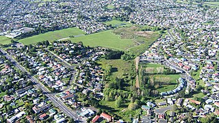
The Panmure Basin, also sometimes known as the Panmure Lagoon, is a tidal estuary within a volcanic crater or maar in New Zealand's Auckland volcanic field. It is located to the south of Panmure town centre.

Tank Farm is the name of a volcanic explosion crater on the North Shore of Auckland, New Zealand, near the approaches to the Auckland Harbour Bridge.

Onepoto is the name of a volcanic explosion crater on the North Shore in Auckland, New Zealand. It is a part of the Auckland volcanic field. It should not be confused with Onepoto Hill, which is a volcanic feature of the South Auckland volcanic field.

Matukutūreia / McLaughlins Mountain is one of the volcanic cones in the Auckland volcanic field. It has a peak 73 metres above sea level, and was the site of a pā. The scoria cone was originally crescent-shaped and featured Māori terraces and kumara pits, before extensive quarrying reduced it to a pyramid-shaped mound big enough to support the summit water tank for Papatoetoe. A small part of the summit and the eastern side of the cone were left unquarried, plus a large area of lava flows to the south of the cone remains intact. These remaining parts have recently been transferred to Department of Conservation Management, primarily because of the high heritage values of the Matukuturua Stonefields gardens.

Crater Hill is one of the volcanoes of the Auckland volcanic field, in New Zealand. It consists of an explosion crater about 600 metres (2,000 ft) wide, partly filled with water. The hill, alongside Māngere Lagoon, Waitomokia, Kohuora, Pukaki Lagoon and Robertson Hill, is one of the volcanic features collectively referred to as Nga Tapuwae a Mataoho, referring to the deity in Tāmaki Māori myths who was involved in their creation.

Te Hopua a Rangi, also known as Gloucester Park, is one of the volcanoes in the Auckland volcanic field in Auckland, New Zealand, and is located in Onehunga. Its 300 m wide, sediment-filled explosion (maar) crater was used as a boat harbour in early European times and known first as Onehunga Basin then as Geddes Basin. It was reclaimed in the 1930s and named Gloucester Park in 1935 after the visit to New Zealand by the Duke of Gloucester in that year. From 1975 into the early 1980s the Southwestern Motorway was built right through the middle of the park and crater. The southern side was turned into a sports ground, and the western side as a wetland with activity space for Aotea Sea Scouts who took ownership of the Manukau Yacht and Motor Boat Club (MYMBC) club house in 1977.

Waitomokia is a volcano in the Auckland volcanic field. Waitomokia's 600 m (2,000 ft) wide tuff crater contained three small scoria cones up to 20 m (66 ft) high, one with a crater, which were quarried in the 1950s.

Ash Hill is a volcano in Wiri, in the Auckland volcanic field, in New Zealand. A low tuff cone with an explosion crater about 150m wide, it is now covered by industrial development. It peaked at roughly 30 metres above sea level.

Maungataketake is one of the volcanoes in the Auckland volcanic field in New Zealand. It had a 76 m high scoria cone, beside a 100 m wide crater, before they were quarried away. It was the site of a pā. Layers of volcanic tuff and ash from Maungataketake overlay the fallen trunks of the nearby Ihumātao fossil forest. The New Zealand Ministry for Culture and Heritage gives a translation of "broad mountain" for Maungataketake.
Pukaki Lagoon, located in the suburb of Māngere, New Zealand, is one of the volcanoes in the Auckland volcanic field. The lagoon, alongside Māngere Lagoon, Waitomokia, Crater Hill, Kohuora and Robertson Hill, is one of the volcanic features collectively referred to as Nga Tapuwae a Mataoho, referring to the deity in Tāmaki Māori myths who was involved in their creation.

Pukeiti is one of the volcanoes in the Auckland volcanic field. The spatter cone is the smallest volcano in Auckland, reaching 30 metres (98 ft) above sea level, and has a shallow crater over 30 metres (98 ft) wide. The crater rim was quarried on the south and east side. Extensive lava poured out from this vent to form a lava flow field to the north and east. It is now part of the Otuataua Stonefields reserve.

Purchas Hill is one of the volcanoes in the Auckland volcanic field.

Robertson Hill is one of the volcanoes in the Auckland volcanic field in New Zealand. It erupted approximately 24,300 years ago. The hill, alongside Māngere Lagoon, Waitomokia, Crater Hill, Kohuora and Pukaki Lagoon, is one of the volcanic features collectively referred to as Nga Tapuwae a Mataoho, referring to the deity in Tāmaki Māori myths who was involved in their creation.

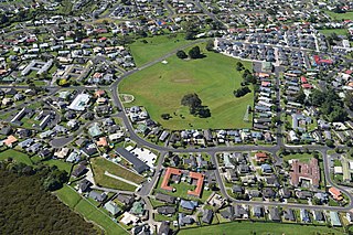
Hampton Park is one of the volcanoes in the Auckland volcanic field. A small scoria cone reaching 35 metres above sea level, with a shallow crater around 50 metres wide, which has been modified by quarrying. The scoria cone sits in the centre of a much larger explosion crater, the eastern arc of the surrounding tuff ring is still present. Stone from the volcano was used to build dry-stone walls and the nearby St John's Church built on the tuff ring crest.

Styaks Swamp is one of the volcanoes in the Auckland volcanic field, found in the suburb of East Tāmaki.

Cemetery Crater is one of the volcanoes in the Auckland volcanic field. It is an explosion crater roughly 200 metres (660 ft) wide, located east of Crater Hill. Hard to see even in early aerial photos due to its shallowness, it is now covered by housing.
Kohuora, located in the suburb of Papatoetoe, is one of the volcanoes in the Auckland volcanic field in the North Island of New Zealand.
Boggust Park Crater is a volcano in the Auckland volcanic field, New Zealand. Located in the Favona area of the Māngere suburb, it is one of Auckland city's older volcanoes. It was first recognised as a volcano in 2011. The park in which it is located is named after Ralph Boggust, former superintendent of Manukau Parks Dept.
Grafton Volcano is a buried volcano in New Zealand's Auckland volcanic field that underlies much of the Auckland suburb of Grafton. First recognised in 2010, it includes the Outhwaite Park scoria cone that was first mapped by Hochstetter (1864) and inferred by later geologists to be a late phase vent of adjacent Pukekawa Volcano. Borehole drilling and building excavations in the Grafton-Auckland Domain area during the 1990s and 2000s provided new subsurface geological information that allowed geologists to recognise the buried Grafton Volcano.

The Puhinui Craters are located in Auckland's Puhinui Reserve and are part of the Auckland volcanic field in the North Island of New Zealand. They were first recognised as volcanic craters in 2011. A cluster of three small maar craters like these is unique in the Auckland volcanic field. Their ages are unknown but most probably all three erupted during the same eruptive episode. They could have been associated with the eruption of nearby Matukutureia but this is speculation at present.


