Papatoetoe

Last updated

Papatoetoe
Rangitoto and Auckland 31-03-2012 14-03-10 - cropped to Papatoetoe.png
Aerial view of Papatoetoe
Papatoetoe
Coordinates: 36°58′47″S174°51′04″E / 36.979770°S 174.851224°E / -36.979770; 174.851224
CountryNew Zealand
City Auckland
Local authority Auckland Council
Electoral ward Manukau ward
Local board Ōtara-Papatoetoe Local Board
Area
[1]
  Land1,110 ha (2,740 acres)
Population
 (June 2022) [2]
  Total49,130
Train stations Papatoetoe Train Station
Puhinui Train Station
Māngere East Middlemore Ōtara
(Towards Auckland Airport)
Pfeil oben.svg
Pfeil links.svgPapatoetoePfeil rechts.svg
Pfeil unten.svg
Flat Bush
(Towards Manukau Harbour) Manukau Central Manukau Central

Papatoetoe is a suburb in Auckland, New Zealand. It is the largest suburb in Auckland by population [3] and is located to the northwest of Manukau Central, and 18 kilometres southeast of Auckland CBD.

Contents

Papatoetoe was traditionally an important area for Tāmaki Māori, who used a waka portage between the Tāmaki River and Waokauri Creek to reach the Manukau Harbour, as an alternative to the Ōtāhuhu portage to the north. The area developed as a farming community in the 19th century, and grew significantly in the 1950s and 1960s after the Auckland Southern Motorway was constructed. Papatoetoe is now known for its significant population of Indian New Zealanders. Papatoetoe is the only suburb in South Auckland where Māori/Pacific Islanders do not form the majority of the suburb's population, [4] and is one of the most rapidly gentrifying suburbs in Auckland. [5]

Etymology

Papatoetoe means "grounds where toetoe grows", referring to species of Austroderia grasses that traditionally grew in the area. [6] [7] The name Papatoetoe was first used by English settlers from the 1850s onwards. [8] The spelling Papatoitoi was common in English in the 19th Century, and was gradually replaced with Papatoetoe after the local post office began using this spelling. [9]

Geology

Kohuora is a tuff crater located in Papatoetoe Kohuora Explosion Crater 2009.jpg
Kohuora is a tuff crater located in Papatoetoe

Papatoetoe is low-lying flat area in South Auckland, located south of the Auckland isthmus and east of the Māngere peninsula. [7] Some features of the Auckland volcanic field can be found around Papatoetoe, including Kohuora, a tuff ring that erupted an estimated 34,000 years ago, [10] becoming a wetland after the crater gradually filled with water and sediment, [7] and Crater Hill, which erupted an estimated 30,000 years ago. [10] The low-lying volcanic features of South Auckland were collectively known by the name Nga Tapuwae a Mataoho ("The Sacred Footprints of Mataoho") to Tāmaki Māori peoples, referring to the deity who was involved in their creation. [11] [12]

Papatoetoe is a flat area between the catchments of the Manukau Harbour in the west and the Tāmaki River to the north-east. Major waterways in the area include the Waokauri Creek, the Puhinui Creek to the south, and the north-flowing Tāmaki River and Ōtara Creek.

The area was forested before human occupation, and by the 1840s was covered in a mix of fern and scrub, including plants such as kānuka, mānuka and toetoe. [7]

History

Māori history

The Waokauri / Pukaki portage allowed for waka to cross between the Manukau Harbour and the Tamaki River, south of the Otahuhu portage Rangitoto and Auckland 31-03-2012 14-03-10.jpg
The Waokauri / Pūkaki portage allowed for waka to cross between the Manukau Harbour and the Tāmaki River, south of the Ōtāhuhu portage

The first evidence of Tāmaki Māori in the coastal Manukau Harbour area comes from the 14th century, with evidence of the first settlements later in the 15th century. [13] Papatoetoe formed an important part of the Waokauri / Pūkaki portage, connecting the Manukau Harbour and Tāmaki River, and was often used by Tāmaki Māori to avoid the Te Tō Waka and Karetu portages, controlled by the people who lived at Ōtāhuhu / Mount Richmond. [14] Papatoetoe is within the traditional rohe of Waiohua, including the modern Tainui/Waiohua iwi Te Ākitai Waiohua. [15] A Te Ākitai whakatauki (proverb) defines the boundaries of Papatoetoe:

"Kohuora ki te uru, Tāmaki moana ki uta, he toetoe hei tipare ki waenganui"
"Kohuora to the west, the shores of the Tāmaki River and a head dress of toetoe in the middle". [7]

Compared to other parts of Tāmaki Makaurau (the Auckland Region), there are few fortified sites in Papatoetoe due to the flat land. There is one known in the Papatoetoe area, at Cemetery Crater (Hillside South Park). [8] The pā is known by the name Te Pā-o-te-tū-tahi-atu, a name that describes the pā as temporary, due to the surrounding flat landscape not being ideal for fortifications. [16]

The Waokauri / Pūkaki portage was actively used during the early colonial era until the 1860s, as a way to transport goods to Papatoetoe. [8]

Colonial era

The old Papatoetoe Railway Station Old Papatoetoe Railway Station (14083645241).jpg
The old Papatoetoe Railway Station

In January 1836 missionary William Thomas Fairburn brokered a land sale between Tāmaki Māori chiefs, Pōtatau Te Wherowhero and Turia of Ngāti Te Rau, covering the majority of modern-day South Auckland between Ōtāhuhu and Papakura. The sale was envisioned as a way to end hostilities in the area, but it is unclear what the chiefs understood or consented to. Māori continued to live in South Auckland, unchanged by this sale. [17] Fairburn was criticised for the sheer size of the purchase, and in 1842 the Crown significantly reduced the size of his land holdings, [18] and the Crown partitioned much of the land for European settlers. [17]

In April 1851, the Tāmaki Bridge was constructed along the Great South Road, spurring growth in the Papatoetoe area. [8] In 1855 the road was metalled, and coach services to Auckland began in 1857 when the road reached as far south as Drury. [7] European settlers began settling in the area from the 1850s, primarily Scottish and Irish Presbyterians. The area was sparsely populated, featuring large country houses such as Hillside, Puhi Nui and Papahinu. The first St Johns Presbyterian Church was built in 1855 (later replaced by wooden Gothic and brick churches). [7] In 1861, Governor George Grey ordered the construction of the Great South Road further into the Waikato, to improve supply lines through swampy and thickly forested country, prior to the Invasion of the Waikato. [19] On 9 July 1863, due to fears of the Māori King Movement, Governor Grey proclaimed that all Māori living in the South Auckland area needed to swear loyalty to the Queen and give up their weapons. Most people refused due to strong links to Tainui, leaving for the south. During this time, the Te Ākitai Waiohua rangatira Īhaka Takaanini was arrested and died on Rakino Island. [20] After the war, the Crown confiscated 1.2 million acres of Māori land around the Waikato, including Waiohua land in South Auckland. [7]

The first local government in the area was the Papatoitoi Highway District, which was defined in 1865 and began meeting from in 1868. [7] In 1875, the Papatoetoe railway station opened, connecting Papatoetoe to Auckland in the north. The new township began developing around the railway station, and by the 1880s dairy farming had become popular in the area. [7]

Suburban growth

St George Street in Papatoetoe, circa 1925 View of St George Street, Papatoetoe, ca 1925 (cropped).jpg
St George Street in Papatoetoe, circa 1925
Members of the Punjabi Cultural Association of New Zealand participating in the 2004 Papatoetoe Santa Parade Santa Parade, Papatoetoe, 2004.jpg
Members of the Punjabi Cultural Association of New Zealand participating in the 2004 Papatoetoe Santa Parade

Housing estates began developing in Papatoetoe in the early 1900s, primarily to the east of the railway station. These included the Kolmar Estate (1903), Central Estate (1912), the Ideal Estate (1913), Llanforda Estate (1913), Station Estate (1913), and the Green Park Estate (1914). [7] By 1911, the population of Papatoetoe had doubled to 400 people. [7] In March 1912, a temporary military camp was established for the 3rd (Auckland) Regiment at Puhinui. [7]

In 1918, a public hall was constructed for Papatoetoe, and in the following year growth in the area meant that Papatoetoe became a town district. [7] Papatoetoe became one of the fastest growing areas of Auckland in the 1920s, and a second commercial area began to develop in Papatoetoe, at the motor bus service terminus on Great South Road, near the Hunter's tearooms, which developed into Hunters Corner. [8] During the Great Depression, growth slowed in Papatoetoe, and the area became known for poultry farming. [7] In 1929, the Waitemata Brewery opened near Papatoetoe, operated by the Dominion Brewery. [7]

During World War II, the Cambria Park estate was requisitioned by the Public Works Department, who constructed a military camp for 6,000 troops from the United States Army. Middlemore Hospital opened in 1947, intended as a temporary military hospital, later becoming permanent. [7]

Papatoetoe grew large enough to become a borough in 1946. [7] In the late 1940s and early 1950s, the Māori Affairs Department of the New Zealand Government encouraged growth in the Papatoetoe area, leading to an influx of Urban Māori moving from rural areas of the country. [7]

The development of the Auckland Southern Motorway led to an explosion in the population of Papatoetoe, with the population increasing four times in the post-World War II period. The motorway opened between Ellerslie and Redoubt Road in 1955. [7] In 1958, the first modern supermarket in New Zealand was opened in Papatoetoe, by Tom Ah Chee, Norm Kent and John Brown, [8] and in 1962 Nestlé opened a factory at Cambria Park in Papatoetoe, becoming a major employer in the area. [7]

Papatoetoe became a city in 1965, and was amalgamated into Manukau City in 1989. [7] In 1991, the Hunters Plaza mall was opened. [8] Population growth had mostly ceased and remained stagnant throughout the 1990s and early 2000s, however a significant increase in population occurred after 2006 due to high rates of immigration and changes to the Auckland Unitary Plan allowing more intensive infill housing on large sections. [21] Papatoetoe has the unofficial title of Auckland's Little India, with 40 percent of the suburb's population being of Indian ethnicity according to the 2018 census. [22] [4]

Local government

The first local government in the area was the Papatoitoi Highway District, which was defined in 1865. This was succeeded by the Papatoetoe Town Board in 1919. [7] In 1946, population growth led to Papatoetoe becoming a borough, and by 1965 Papatoetoe became a city. With the local government reforms of 1989, Papatoetoe was amalgamated into the Manukau City. [8] In November 2010, all cities and districts of the Auckland Region were amalgamated into a single body, governed by the Auckland Council. [23] The old Papatoetoe City Council building is at 91 Cambridge Terrace, Papatoetoe.

Papatoetoe is a part of the Ōtara-Papatoetoe local board, who elect members to the Ōtara-Papatoetoe Local Board, as well as two Manukau ward councillors who sit on the Auckland Council.

List of mayors

NameTerm
Papatoetoe Borough Council
1Victor Maurice Tracey1946–1948
2Thomas Richard Smytheman1948–1953
3Cyril James Mahon1953–1959
4Lee Isbister Murdoch1959–1965
Papatoetoe City Council
5 Bob White 1965–1986
6Allan Walter Brewster1986–1989

Demographics

Papatoetoe covers 11.10 km2 (4.29 sq mi) [1] and had an estimated population of 49,130 as of June 2022, [2] with a population density of 4,426 people per km2.

Historical population
YearPop.±% p.a.
200634,188    
201338,238+1.61%
201843,599+2.66%
Source: [24]

Papatoetoe had a population of 43,599 at the 2018 New Zealand census, an increase of 5,361 people (14.0%) since the 2013 census, and an increase of 9,411 people (27.5%) since the 2006 census. There were 11,469 households, comprising 22,248 males and 21,354 females, giving a sex ratio of 1.04 males per female, with 9,288 people (21.3%) aged under 15 years, 12,051 (27.6%) aged 15 to 29, 18,405 (42.2%) aged 30 to 64, and 3,852 (8.8%) aged 65 or older.

Ethnicities were 19.8% European/Pākehā, 12.7% Māori, 29.1% Pacific peoples, 50.1% Asian, and 2.1% other ethnicities. People may identify with more than one ethnicity.

The percentage of people born overseas was 51.6, compared with 27.1% nationally.

Although some people chose not to answer the census's question about religious affiliation, 17.9% had no religion, 36.4% were Christian, 1.3% had Māori religious beliefs, 18.2% were Hindu, 6.4% were Muslim, 2.3% were Buddhist and 12.5% had other religions.

Of those at least 15 years old, 6,060 (17.7%) people had a bachelor's or higher degree, and 6,120 (17.8%) people had no formal qualifications. 2,910 people (8.5%) earned over $70,000 compared to 17.2% nationally. The employment status of those at least 15 was that 17,913 (52.2%) people were employed full-time, 4,278 (12.5%) were part-time, and 1,593 (4.6%) were unemployed. [24]

Individual statistical areas
NameArea
(km2)
PopulationDensity
(per km2)
HouseholdsMedian ageMedian
income
Grange1.432,1871,52946226.8 years$22,100 [25]
Papatoetoe North0.994,7794,8271,32030.2 years$30,200 [26]
Dingwall0.833,4084,10690031.3 years$30,900 [27]
Aorere South1.244,9443,9871,15528.8 years$27,800 [28]
Papatoetoe West1.224,7553,8981,23329.3 years$30,300 [29]
Papatoetoe Central1.465,0853,4831,54533.3 years$28,000 [30]
Papatoetoe East1.074,3624,0771,12530.5 years$27,000 [31]
Papatoetoe South West0.833,7294,49390629.1 years$28,100 [32]
Papatoetoe South0.803,9724,9651,12232.0 years$27,700 [33]
Puhinui North0.703,8525,5031,08331.8 years$30,300 [34]
Puhinui South0.532,5264,76661830.1 years$29,000 [35]
New Zealand37.4 years$31,800

Economy

St George Street, Town Centre. Papatoetoe Town Centre, A Car Paradise.jpg
St George Street, Town Centre.

Papatoetoe Town Centre

In early 2009 planning began to revitalise the town centre in the St. George Street area. The plan envisaged new apartment buildings and nearby sports facilities bringing more business to the area, which had struggled due to competition from shopping malls. [36]

Hunter's Corner

Hunter's Corner has become a popular shopping area for shoppers of Indian origin. Hunter's Corner accounts for 60 retail outlets of which about 40 have some form of Indian flavour. [22]

Hunter's Corner used to be a notorious area for prostitution in the early 2000s due to it being relatively safer compared to similar town centres in South Auckland, however prostitution has largely disappeared in recent times after strong opposition from local residents. [37]

Hunters Plaza

The Hunters Plaza shopping mall opened in 1991 and was upgraded in 2015. [38] It features 47 stores, including Kmart and Countdown. [39]

Transport

Papatoetoe contains two train stations within the suburban limits. These include the Papatoetoe railway station situated in Old Papatoetoe and nearby Puhinui railway station situated in Puhinui Road. Both the Eastern Line and the Southern Line services both train stations. During peak times there is a train approximately every 5 minutes heading towards Britomart. It takes approximately 30 minutes from Papatoetoe railway station into Britomart. The Puhinui Station Interchange was upgraded in July 2021 to provide a rapid transit network to Auckland Airport, as well as forming a connection with Manukau. It takes approximately 10–12 minutes from Puhinui Station to Auckland Airport. [40] [41]

Auckland Southern Motorway and Southwestern Motorway connect Papatoetoe with Auckland City and Manukau. Southwestern Motorway interchanges are on Puhinui Road to the south and Massey Road in Māngere East to the north. The Southern Motorway interchange is on East Tamaki Road.

Sports

Association football

Papatoetoe is home to Papatoetoe AFC who compete in the Lotto Sport Italia NRFL Division 1A. Papatoetoe is home to Papatoetoe United who play from the sports complex on Great South Road and are affiliated with Auckland Football Federation.

Cricket

Papatoetoe is home to the Papatoetoe Cricket Club who play in the Auckland Cricket Championship.

Rugby league

Papatoetoe is home to the Papatoetoe Panthers who are affiliated with the Auckland Rugby League.

Rugby union

Papatoetoe Rugby Football Club was established in 1946 and plays home matches at the Papatoetoe Sport Complex on Great South Road.

Tennis

Papatoetoe is home to two tennis clubs, Papatoetoe Tennis Club located at Papatoetoe Sports Complex and Sunnyside Tennis Club located in the Sunnyside Domain. Both clubs are affiliated to Auckland Tennis. Sunnyside Tennis Club was formed originally as Puhunui Tennis Club in 1955.

Education

Primary education

Papatoetoe has five primary schools in its zone:

In addition, Papatoetoe North School, Puhinui School and South Auckland Seventh-day Adventist School could be considered to be in Papatoetoe.

Papatoetoe has one intermediate school:

Kedgley Intermediate is on the boundary of the Papatoetoe area.

Secondary education

Papatoetoe has two secondary schools:

All these schools are coeducational. Rolls are as of April 2023. [51]

Papatoetoe Historical Society

Papatoetoe Historical Society was established in 1988 with the aim to gather the historical artifacts and information from the Papatoetoe district. The collection held includes a collation of information on Local Body members, schools as they developed, the origin and meaning of street names, women of the district (book available), people of the surrounding farming district, newspaper cuttings and information on local organisations. The society has also developed an archive collection which includes photographs, books, booklets, plans and posters. These collections can be viewed at the Papatoetoe Historical Society museum, currently being set up at the Papatoetoe Chambers, 35 St George St, Papatoetoe following its relocation from The Depot . [52] [53]

In 2012, Papatoetoe celebrated 150 years of civic life. The Papatoetoe 150 was initiated by the Papatoetoe Historical society to increase awareness of history and promote community organisations.

Notable people

Attractions

Papatoetoe's Old Railway Station - a local landmark. Papatoetoe Old Train Station.jpg
Papatoetoe's Old Railway Station – a local landmark.
  • "Picnic Scene" by Ron van Dam (near Wallace Road corner)
  • "Papatoetoe General Store" by Christine Trout (Papatoetoe Mall)
  • "Bottle O" by Christine Trout (Papatoetoe Mall)
  • "Cameos" by Claudia Pond-Eyley (near Town Hall)
  • "Old Papatoetoe Logo" by Ron van Dam (near Shirley Road)
  • "St George St – 1930" by Merv Appleton (Rangitoto Road)
  • Old Railway Station
  • Cambria House and associated historic gardens (Puhinui Road)
  • Old Children's home (now in Wyllie Road)

Related Research Articles

<span class="mw-page-title-main">Waiuku</span> Town in Auckland Region, New Zealand

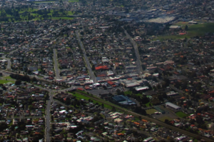
Waiuku is a rural town in the Auckland Region of New Zealand. It is located at the southern end of the Waiuku River, which is an estuarial arm of the Manukau Harbour, and lies on the isthmus of the Āwhitu Peninsula, which extends to the northeast. It is 40 kilometres southwest of Auckland city centre, and 12 kilometres north of the mouth of the Waikato River.

<span class="mw-page-title-main">South Auckland</span> Region of Auckland, New Zealand

South Auckland is one of the major geographical regions of Auckland, the largest city in New Zealand. The area is south of the Auckland isthmus, and on the eastern shores of the Manukau Harbour. The area has been populated by Tāmaki Māori since at least the 14th century, and has important archaeological sites, such as the Ōtuataua stonefield gardens at Ihumātao, and Māngere Mountain, a former pā site important to Waiohua tribes.

<span class="mw-page-title-main">Great South Road, New Zealand</span>

The Great South Road was the northern section of the earliest highway between Auckland and Wellington, in the North Island of New Zealand.

<span class="mw-page-title-main">Māngere</span> Suburb in Auckland, New Zealand

Māngere is a major suburb in South Auckland, New Zealand, located on mainly flat land on the northeastern shore of the Manukau Harbour, to the northwest of Manukau City Centre and 15 kilometres south of the Auckland city centre. It is the location of Auckland Airport, which lies close to the harbour's edge to the south of the suburb.

<span class="mw-page-title-main">Manurewa</span> Suburb in Auckland, New Zealand

Manurewa is a major suburb in South Auckland, New Zealand, located 6 km (3.7 mi) south of Manukau Central, and 26 km (16 mi) southeast of the Auckland City Centre. It is home to the Auckland Botanic Gardens, which receives over a million visitors a year. Manurewa has a high proportion of non-European ethnicities, making it one of the most multi-cultural suburbs in New Zealand. Employment for many is at the many companies of nearby Wiri, Papakura, and at the steel mill at Glenbrook.

<span class="mw-page-title-main">Māngere Bridge (suburb)</span> Suburb of Auckland in New Zealand

Māngere Bridge is a suburb of Auckland, New Zealand, under the local governance of the Auckland Council. Surrounded by the Manukau Harbour, the area is the most north-western suburb of South Auckland, and is connected to Onehunga in central Auckland by three bridges that cross the Māngere Inlet. Many features of the Auckland volcanic field are found in and around Māngere Bridge, including Māngere Mountain, a 106-metre-high (348 ft) feature in the centre of the suburb, and Māngere Lagoon, a volcanic tidal lagoon opposite Puketutu Island in the harbour. The suburb is also home to Ambury Regional Park, a working farm and nature sanctuary run by Auckland Council, that connects to the Kiwi Esplanade and Watercare Coastal walkways.

<span class="mw-page-title-main">East Tāmaki</span> Suburb in Auckland, New Zealand

East Tāmaki is a suburb of Auckland, New Zealand. It is a largely industrial area adjacent to a rapidly growing population. Prior to the 1960s it was largely a dairy farming area. A landmark is Smales Mountain which in 2010 has the remains of an old Pa, a stone field garden, an early church, and farm homestead. A newer landmark is the Fo Guang Shan Temple which was the largest Buddhist temple in New Zealand when it opened in 2007.

<span class="mw-page-title-main">Ōtāhuhu</span> Suburb in Auckland, New Zealand

Ōtāhuhu is a suburb of Auckland, New Zealand – 13 kilometres (8.1 mi) to the southeast of the CBD, on a narrow isthmus between an arm of the Manukau Harbour to the west and the Tāmaki River estuary to the east. The Auckland isthmus is the narrowest connection between the North Auckland Peninsula and the rest of the North Island, being only some 1,200 metres (3,900 ft) wide at its narrowest point, between the Ōtāhuhu Creek and the Māngere Inlet. As the southernmost suburb of the former Auckland City, it is considered part of South Auckland.

<span class="mw-page-title-main">Flat Bush</span> Suburb in Auckland, New Zealand

Flat Bush is a southern suburb in the city of Auckland, New Zealand. It has recently become one of the city's largest new planned towns after being developed as a rural area of Auckland for several decades. Located near Manukau Heights, plans for substantial expansion began under the Manukau City Council - having bought 290 hectares in the area in 1996.

<span class="mw-page-title-main">State Highway 20 (New Zealand)</span> Road in New Zealand

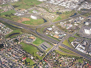
State Highway 20 (SH 20), also known as the Southwestern Motorway, is a New Zealand state highway linking State Highway 1 at Manukau with State Highway 16 in Point Chevalier, via Māngere and Onehunga. Along with its spurs, State Highway 20A and 20B, the state highway serves Auckland Airport, the country's largest, therefore making SH 20 a key arterial route connecting the airport to the wider Auckland region and most of the upper North Island. The route also forms the southern part of the Western Ring Route, a 48 kilometres (30 mi) motorway route bypassing central Auckland.

<span class="mw-page-title-main">Manukau</span> Suburb in Auckland, New Zealand

Manukau, or Manukau Central, is a suburb of South Auckland, New Zealand, centred on the Manukau City Centre business district. It is located 23 kilometres south of the Auckland Central Business District, west of the Southern Motorway, south of Papatoetoe, and north of Manurewa. The industrial and commercial suburb of Wiri lies to the east and south.

<span class="mw-page-title-main">Ōtara</span> Suburb in Auckland, New Zealand

Ōtara is a suburb of South Auckland, New Zealand, situated 18 kilometres to the southeast of the Auckland City Centre. Ōtara lies near the head of the Tamaki River, and is surrounded by the suburbs of Papatoetoe, East Tāmaki, Clover Park and Flat Bush. The area is traditionally part of the rohe of Ngāi Tai ki Tāmaki, and the name Ōtara refers to Ōtara Hill / Te Puke ō Tara, a former Ngāi Tai ki Tāmaki pā and volcanic hill to the north of the suburb. From 1851 to 1910 the area was part of the Goodfellow family farm, and during the 1910s the area was an agricultural college run by the Dilworth Trust.

<span class="mw-page-title-main">Te Ākitai Waiohua</span> Māori iwi in New Zealand

Te Ākitai Waiohua is a Māori iwi of the southern part of the Auckland Region of New Zealand.

<span class="mw-page-title-main">Māngere East</span> Suburb in Auckland, New Zealand

Māngere East or Mangere East is a suburb of Auckland, New Zealand, under the governance of Auckland Council. It is located to the south of Favona, north of Papatoetoe, west of Middlemore, east of Māngere and Māngere Bridge, and southwest of Ōtāhuhu.

<span class="mw-page-title-main">Ōtara-Papatoetoe Local Board</span> Local board of Auckland Council in New Zealand

The Ōtara-Papatoetoe Local Board is one of the 21 local boards of the Auckland Council. It is overseen by the Manukau ward councillors.

<span class="mw-page-title-main">Pūkaki Creek</span> River in Auckland Region, New Zealand

The Pūkaki Creek, also known as the Pūkaki Inlet, is an estuarine river of the Auckland Region of New Zealand's North Island. It flows south from its sources in Māngere and Papatoetoe, entering into the Manukau Harbour. The creek is adjacent to Auckland Airport and Pūkaki Marae.

<span class="mw-page-title-main">Portages of New Zealand</span>

Portages in New Zealand, known in Māori as or Tōanga Waka, are locations where waka (canoes) could easily be transported overland. Portages were extremely important for early Māori, especially along the narrow Tāmaki isthmus of modern-day Auckland, as they served as crucial transportation and trade links between the east and west coasts. Portages can be found across New Zealand, especially in the narrow Northland and Auckland regions, and the rivers of the Waikato Region.

<span class="mw-page-title-main">Puhinui Reserve</span> Protected working farm in Auckland

The Puhinui Reserve is a protected working farm and wetland area in South Auckland, New Zealand, on the shores of the Manukau Harbour. It is the location of the Puhinui Craters, and is an area of historic significance to Waiohua iwi.

<span class="mw-page-title-main">Puhinui Creek</span> River in Auckland Region, New Zealand

The Puhinui Creek, also known as the Puhinui Stream or Te Puhinui, is a major stream in South Auckland, in the Auckland Region of New Zealand's North Island. It flows westwards from Totara Park through Manukau, then southwest at Wiri to the Manukau Harbour.

<span class="mw-page-title-main">Ōtara Creek</span> Stream in Auckland, New Zealand

The Ōtara Creek, is a major stream in South Auckland, in the Auckland Region of New Zealand's North Island. It flows northwards, then westwards into the Tāmaki River.

References

  1. 1 2 "ArcGIS Web Application". statsnz.maps.arcgis.com. Retrieved 8 August 2022.
  2. 1 2 "Population estimate tables - NZ.Stat". Statistics New Zealand . Retrieved 25 October 2022.
  3. "2018 Census place summaries | Stats NZ".
  4. 1 2 "Ethnic group (detailed total response - level 3) by age and sex, for the census usually resident population count, 2006, 2013, and 2018 Censuses (RC, TA, SA2, DHB)". nzdotstat.stats.govt.nz. Retrieved 3 March 2021.
  5. "Colliers' pick of the top residential areas for medium- to long-term growth". colliers.co.nz. 21 December 2021. Retrieved 7 July 2022.
  6. Our Auckland (18 May 2021). "Māori names and stories showcased in local parks". Auckland Council . Retrieved 28 April 2023.
  7. 1 2 3 4 5 6 7 8 9 10 11 12 13 14 15 16 17 18 19 20 21 22 23 Auckland Council Heritage Unit (2014). "Papatoetoe Historic Heritage Survey: Survey Report" (PDF). Auckland Council . Retrieved 28 April 2023.
  8. 1 2 3 4 5 6 7 8 "Papatoetoe Heritage Trail" (PDF). Ōtara-Papatoetoe Local Board. 2013. Retrieved 31 March 2023.
  9. "1 April 1897". Manukau's Journey. Auckland Libraries Heritage Collections. MJ_1386. Retrieved 27 April 2023.
  10. 1 2 Hopkins, Jenni L.; Smid, Elaine R.; Eccles, Jennifer D.; Hayes, Josh L.; Hayward, Bruce W.; McGee, Lucy E.; van Wijk, Kasper; Wilson, Thomas M.; Cronin, Shane J.; Leonard, Graham S.; Lindsay, Jan M.; Németh, Karoly; Smith, Ian E. M. (3 July 2021). "Auckland Volcanic Field magmatism, volcanism, and hazard: a review". New Zealand Journal of Geology and Geophysics. 64 (2–3): 213–234. doi:10.1080/00288306.2020.1736102. S2CID   216443777.
  11. "The History of Our Marae". Makaurau Marae. Retrieved 1 September 2021.
  12. Simmons, D. R. (1979). "George Graham's Maori Place Names of Auckland". Records of the Auckland Institute and Museum . 16: 11–39. ISSN   0067-0464. JSTOR   42906272. Wikidata   Q58677091.
  13. Mackintosh 2021, pp. 28.
  14. "Papatoetoe street names". Auckland Libraries. Retrieved 16 May 2022.
  15. Gibb, Russell (1 September 2015). "Archaeological Assessment of Self Farm / Crater Hill, Papatoetoe, Auckland". Geometria Limited. Retrieved 16 May 2022.
  16. "Pā o Tahi / Hillside South Park". Auckland Council . Retrieved 28 April 2023.
  17. 1 2 Moore, D; Rigby, B; Russell, M (July 1997). Rangahaua Whanui National Theme A: Old Land Claims (PDF) (Report). Waitangi Tribunal . Retrieved 5 March 2023.
  18. Wichman, Gwen 1990, pp. 3.
  19. O'Malley, Vincent (6 December 2016). "'The great war for NZ broke out less than 50 km from Queen St': Vincent O'Malley on the Waikato War and the making of Auckland". The Spinoff . Retrieved 30 March 2023.
  20. Mackintosh 2021, pp. 100–101, 107.
  21. "Statistical area 1 dataset for 2018 Census – updated March 2020 | Stats NZ".
  22. 1 2 Bakshi, Kanwaljit Singh (14 August 2019). "Papatoetoe in South Auckland emerges as Little India". indiannewslink.co.nz. Retrieved 3 March 2021.
  23. Blakeley, Roger (2015). "The planning framework for Auckland 'super city': an insider's view". Policy Quarterly. 11 (4). doi: 10.26686/pq.v11i4.4572 . ISSN   2324-1101.
  24. 1 2 "Statistical area 1 dataset for 2018 Census". Statistics New Zealand. March 2020. Grange (153000), Papatoetoe North (154000), Dingwall (154100), Aorere South (154200), Papatoetoe West (154800), Papatoetoe Central (154900), Papatoetoe East (155600), Papatoetoe South West (155900), Papatoetoe South (156200), Puhinui North (156500) and Puhinui South (156700).
  25. 2018 Census place summary: Grange
  26. 2018 Census place summary: Papatoetoe North
  27. 2018 Census place summary: Dingwall
  28. 2018 Census place summary: Aorere South
  29. 2018 Census place summary: Papatoetoe West
  30. 2018 Census place summary: Papatoetoe Central
  31. 2018 Census place summary: Papatoetoe East
  32. 2018 Census place summary: Papatoetoe South West
  33. 2018 Census place summary: Papatoetoe South
  34. 2018 Census place summary: Puhinui North
  35. 2018 Census place summary: Puhinui South
  36. Facelift to help town centre fight the malls The New Zealand Herald , Wednesday 25 March 2009, Page A8
  37. Thompson, Wayne (31 August 2005). "Residents to rally against Hunters Corner sex trade". NZ Herald. Retrieved 1 February 2019.
  38. "Hunters Plaza completes upgrade". Kiwi Media Publishing. Indian Weekender.
  39. "Hunters Plaza Our Stores". huntersplaza.co.nz. Coast.
  40. Lee, Irra (24 July 2021). "Auckland's $69 million transport hub unveiled". Television New Zealand.
  41. "Puhinui Station Interchange: Papatoetoe's $69m bus and rail hub nears completion". Stuff/Fairfax. 17 June 2021.
  42. Education Counts: Holy Cross School (Papatoetoe)
  43. Education Counts: Papatoetoe Central School
  44. "General Information". Papatoetoe Central School. Retrieved 30 August 2020.
  45. Education Counts: Papatoetoe East School
  46. Education Counts: Papatoetoe South School
  47. Education Counts: Papatoetoe West School
  48. Education Counts: Papatoetoe Intermediate
  49. Education Counts: Papatoetoe High School
  50. Education Counts: Aorere College
  51. "New Zealand Schools Directory". New Zealand Ministry of Education. Retrieved 12 December 2022.
  52. "Papatoetoe Historical Society". New Zealand Historical Societies.
  53. "Papatoetoe Historical Society on NZ Museums". nzmuseums.co.nz. Te Papa.
  54. "Covid 19 coronavirus vaccine: Comedian Mike King blasts 'feral self-righteous' zealots in debate - NZ Herald".
  55. "Kyle Jamieson's story: From shooting hoops to scalping stars". The Indian Express. 21 February 2020.
  56. Hughes, Andrew (October–November 2006). "Feature: Tyree – It's Now or Never". NZ Musician Magazine. 13 (2). Archived from the original on 22 May 2010. Retrieved 27 October 2009.
  57. "We Gon' Ride". Genius. Retrieved 3 December 2022.

Bibliography