
Mount Wellington is a suburb in East Auckland, New Zealand, located 10 km (6.2 mi) southeast of the city centre. It is surrounded by the suburbs of Stonefields, Tamaki, Panmure, Penrose, and Ellerslie, and by the Tāmaki River. The suburb is named after the volcanic peak of Maungarei / Mount Wellington. Sylvia Park is a large business park and shopping centre located in the suburb.

Howick is a suburb of East Auckland, New Zealand. The area was traditionally settled by Ngāi Tai ki Tāmaki, and in 1847 Howick was established as a defensive settlement for Auckland, by veteran fencible soldiers of the British Army. Howick was a small agricultural centre until the 1950s, when it developed into a suburban area of Auckland.

Papatoetoe is a suburb in Auckland, New Zealand. It is the largest suburb in Auckland by population and is located to the northwest of Manukau Central, and 18 kilometres southeast of Auckland CBD.

Māngere is a major suburb in South Auckland, New Zealand, located on mainly flat land on the northeastern shore of the Manukau Harbour, to the northwest of Manukau City Centre and 15 kilometres south of the Auckland city centre. It is the location of Auckland Airport, which lies close to the harbour's edge to the south of the suburb.

Pakuranga is an eastern suburb of Auckland, in northern New Zealand. Pakuranga covers a series of low ridges and previously swampy flats, now drained, that lie between the Pakuranga Creek and Tamaki River, two estuarial arms of the Hauraki Gulf. It is located to the north of Manukau and 15 kilometres southeast of the Auckland CBD.

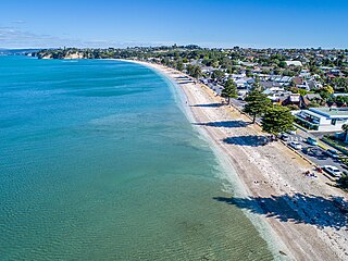
Bucklands Beach is a suburb 13 kilometres (8.1 mi) east of Auckland's CBD in New Zealand. The suburb is in the Howick ward, one of the thirteen administrative divisions of Auckland Council.

Beachlands is an outer suburb of Auckland, New Zealand, established in the 1920s, where development increased in the 1950s due to its popularity as a beach holiday destination. It is located on the Pōhutukawa Coast and in close proximity to Maraetai.

Māngere Bridge is a suburb of Auckland, New Zealand, under the local governance of the Auckland Council. Surrounded by the Manukau Harbour, the area is the most north-western suburb of South Auckland, and is connected to Onehunga in central Auckland by three bridges that cross the Māngere Inlet. Many features of the Auckland volcanic field are found in and around Māngere Bridge, including Māngere Mountain, a 106-metre-high (348 ft) feature in the centre of the suburb, and Māngere Lagoon, a volcanic tidal lagoon opposite Puketutu Island in the harbour. The suburb is also home to Ambury Regional Park, a working farm and nature sanctuary run by Auckland Council, that connects to the Kiwi Esplanade and Watercare Coastal walkways.

Favona is a mostly industry-dominated suburb of Auckland, New Zealand, and is part of the Māngere area. The suburb is in the Manukau ward, one of the thirteen administrative divisions of Auckland city, and is under governance of the Auckland Council.
Highland Park is a suburb of Auckland, New Zealand, located between Howick and Pakuranga. It belongs to the Pakuranga electorate which is currently represented by Simeon Brown.
Eastern Beach is a suburb of Auckland, New Zealand. Located on the eastern city of the city centre, the suburb is in the Howick ward, one of the thirteen administrative divisions of Auckland City. Its most common attraction is a popular white-sand palm fringed beach, also called Eastern Beach, with summer temperatures attracting thousands of people from neighbouring suburbs to the beach to enjoy the shallow waters, and shops and parks within close vicinity. At the southern end of the beach is a boat ramp giving high-medium tide access to the dedicated water skiing zone adjacent to the beach. This was a popular area for gathering Pipi and Cockles, but overuse has seen a rāhui or ban placed on the beach. It is part of the Bucklands Beach peninsula.

Ōtāhuhu is a suburb of Auckland, New Zealand – 13 kilometres (8.1 mi) to the southeast of the CBD, on a narrow isthmus between an arm of the Manukau Harbour to the west and the Tāmaki River estuary to the east. The Auckland isthmus is the narrowest connection between the North Auckland Peninsula and the rest of the North Island, being only some 1,200 metres (3,900 ft) wide at its narrowest point, between the Ōtāhuhu Creek and the Māngere Inlet. As the southernmost suburb of the former Auckland City, it is considered part of South Auckland.

Point England is a suburb of Auckland, New Zealand. It is under the local governance of the Auckland Council.

Half Moon Bay, is a suburb of East Auckland, New Zealand, lying immediately south of Bucklands Beach. It is home to the Half Moon Bay Marina, where over 500 boats berth. It is located on the Tāmaki River in the Hauraki Gulf.

Middlemore Hospital is a major public hospital in the suburb of Ōtāhuhu, Auckland, New Zealand. The hospital has approximately 800 beds. There are 24 operating theatres across two sites.

Ōtara is a suburb of South Auckland, New Zealand, situated 18 kilometres to the southeast of the Auckland City Centre. Ōtara lies near the head of the Tāmaki River. The area is traditionally part of the rohe of Ngāi Tai ki Tāmaki, and the name Ōtara refers to Ōtara Hill / Te Puke ō Tara, a former Ngāi Tai ki Tāmaki pā and volcanic hill to the north of the suburb. From 1851 to 1910 the area was part of the Goodfellow family farm, and during the 1910s the area was an agricultural college run by the Dilworth Trust.

Sunnyhills is a suburb of East Auckland, New Zealand, located on the eastern banks of the Tāmaki River near Pakuranga. Previously farmland within the Pakuranga Town District, suburban housing developed in the area in the mid-1960s.

Māngere East or Mangere East is a suburb of Auckland, New Zealand, under the governance of Auckland Council. It is located to the south of Favona, north of Papatoetoe, west of Middlemore, east of Māngere and Māngere Bridge, and southwest of Ōtāhuhu.

Māngere-Ōtāhuhu Local Board is one of the 21 local boards of the Auckland Council, and is overseen by the council's Manukau ward councillors. The board is governed by seven board members elected at-large. The board's administrative area includes the suburbs Māngere Bridge, Māngere, Ōtāhuhu, and Favona, and covers areas south of the Manukau Harbour.

Golflands is an eastern suburb of the city of Auckland, New Zealand. The Pakuranga Golf Club is part of the suburb, and many of the streets have names related to golf or notable golf players, such as Bob Charles drive.

