Clover Park, New Zealand

Last updated

Clover Park
Clover Park, New Zealand
Coordinates: 36°59′06″S174°53′37″E / 36.9851°S 174.8937°E / -36.9851; 174.8937
CountryNew Zealand
City Auckland
Local authority Auckland Council
Electoral ward Manukau ward
Local board Ōtara-Papatoetoe Local Board
Area
[1]
  Land211 ha (521 acres)
Population
 (June 2023) [2]
  Total9,690
Papatoetoe Ōtara, Flat Bush Flat Bush
Manukau Central
Pfeil oben.svg
Pfeil links.svgClover ParkPfeil rechts.svg
Pfeil unten.svg
Chapel Downs, Manukau Heights
Wiri Hillpark, Manurewa Goodwood Heights, Totara Heights

Clover Park is a suburb of Auckland, New Zealand. It is governed by the Auckland Council, and is in the Manukau ward, one of the thirteen administrative divisions of Auckland city.

Contents

Demographics

Clover Park covers 2.11 km2 (0.81 sq mi) [1] and had an estimated population of 9,690 as of June 2023, [2] with a population density of 4,592 people per km2.

Historical population
YearPop.±% p.a.
20068,064    
20137,941−0.22%
20188,922+2.36%
Source: [3]

Clover Park had a population of 8,922 at the 2018 New Zealand census, an increase of 981 people (12.4%) since the 2013 census, and an increase of 858 people (10.6%) since the 2006 census. There were 1,938 households, comprising 4,425 males and 4,500 females, giving a sex ratio of 0.98 males per female, with 2,448 people (27.4%) aged under 15 years, 2,277 (25.5%) aged 15 to 29, 3,510 (39.3%) aged 30 to 64, and 690 (7.7%) aged 65 or older.

Ethnicities were 14.9% European/Pākehā, 17.9% Māori, 56.4% Pacific peoples, 27.2% Asian, and 1.5% other ethnicities. People may identify with more than one ethnicity.

The percentage of people born overseas was 40.5, compared with 27.1% nationally.

Although some people chose not to answer the census's question about religious affiliation, 21.2% had no religion, 56.9% were Christian, 1.6% had Māori religious beliefs, 7.2% were Hindu, 2.4% were Muslim, 3.7% were Buddhist and 2.4% had other religions.

Of those at least 15 years old, 666 (10.3%) people had a bachelor's or higher degree, and 1,467 (22.7%) people had no formal qualifications. 447 people (6.9%) earned over $70,000 compared to 17.2% nationally. The employment status of those at least 15 was that 3,225 (49.8%) people were employed full-time, 759 (11.7%) were part-time, and 408 (6.3%) were unemployed. [3]

Individual statistical areas
NameArea
(km2)
PopulationDensity
(per km2)
HouseholdsMedian ageMedian
income
Clover Park North0.924,6835,09092426.9 years$23,800 [4]
Clover Park South1.184,2393,5921,01429.7 years$26,900 [5]
New Zealand37.4 years$31,800

Education

Redoubt North School is a full primary (years 1–8) school with a roll of 516. [6]

Kia Aroha College is a secondary school (years 7–13) school with a roll of 336. Some classes are taught in the Māori language and some in Pacific languages. [7] It was formed in January 2011 when Clover Park Middle School merged with Te Whānau o Tupuranga. [8]

Amenities

The Manukau Sports Bowl, a 21.6-hectare (53-acre) park, is located in Clover Park, immediately to the east of the Auckland Southern Motorway. [9] [10] Originally farmland, the land for the park was acquired in the 1960s and 1970s. By the early 1980s, the site included two sports fields. Substantial development took place between 1987 and 1989 with the construction of a greyhound track and a velodrome. Today, facilities in the park include the Auckland Greyhound Track, the Manukau Velodrome, a function centre, a tennis centre, various sports fields, a children's playground, bocce courts and a basketball court. [9]

Since 1996, the Manukau Sports Bowl has been the venue for the annual Polyfest, the world's largest Pacific dance festival, attracting up to 100,000 visitors. [9] [11]

Manukau Velodrome

The Manukau Velodrome was developed by the Manukau City Council at an estimated cost of $4,349,000, following a report setting out the requirement for a velodrome to host track cycling at the 1990 Commonwealth Games. [9] The facility was jointly paid for by the Manukau City Council and the government's Games Enhancement Fund, each providing 25 per cent of the funding, and the Auckland Regional Authority. [9] [12] It opened on 16 September 1989, and hosted the track cycling at the Auckland Commonwealth Games the following January. [10]

During the 2003 World Rally Championship, the velodrome formed part of the course and was the finishing venue for the 2003 Rally New Zealand. [9]

Auckland Greyhound Track

The Auckland Greyhound Track is home to the Auckland Greyhound Racing Club. [9] [13] The track was developed at a cost of $3.2 million, and held its first race meeting on 18 December 1989. [9] [14] In late 2023, the Ōtara-Papatoetoe Local Board announced that the greyhound track would be replaced by an athletics track, and that negotiations were taking place between the Auckland Greyhound Racing Club and Auckland Council to facilitate the club's move away from the Manukau Sports Bowl. [15]

Related Research Articles

<span class="mw-page-title-main">Papatoetoe</span> Suburb in Auckland, New Zealand

Papatoetoe is a suburb in Auckland, New Zealand. It is the largest suburb in Auckland by population and is located to the northwest of Manukau Central, and 18 kilometres southeast of Auckland CBD.

<span class="mw-page-title-main">South Auckland</span> Region of Auckland, New Zealand

South Auckland ) is one of the major geographical regions of Auckland, the largest city in New Zealand. The area is south of the Auckland isthmus, and on the eastern shores of the Manukau Harbour. The area has been populated by Tāmaki Māori since at least the 14th century, and has important archaeological sites, such as the Ōtuataua stonefield gardens at Ihumātao, and Māngere Mountain, a former pā site important to Waiohua tribes.

<span class="mw-page-title-main">Māngere</span> Suburb in Auckland, New Zealand

Māngere is a major suburb in South Auckland, New Zealand, located on mainly flat land on the northeastern shore of the Manukau Harbour, to the northwest of Manukau City Centre and 15 kilometres south of the Auckland city centre. It is the location of Auckland Airport, which lies close to the harbour's edge to the south of the suburb.

<span class="mw-page-title-main">Manurewa</span> Suburb in Auckland, New Zealand

Manurewa is a major suburb in South Auckland, New Zealand, located 6 km (3.7 mi) south of Manukau Central, and 26 km (16 mi) southeast of the Auckland City Centre. It is home to the Auckland Botanic Gardens, which receives over a million visitors a year. Manurewa has a high proportion of non-European ethnicities, making it one of the most multi-cultural suburbs in New Zealand. Employment for many is at the many companies of nearby Wiri, Papakura, and at the steel mill at Glenbrook.

<span class="mw-page-title-main">Favona</span> Suburb in Auckland, New Zealand

Favona is a mostly industry-dominated suburb of Auckland, New Zealand, and is part of the Māngere area. The suburb is in the Manukau ward, one of the thirteen administrative divisions of Auckland city, and is under governance of the Auckland Council.

<span class="mw-page-title-main">East Tāmaki</span> Suburb in Auckland, New Zealand

East Tāmaki is a suburb of Auckland, New Zealand. It is a largely industrial area adjacent to a rapidly growing population. Prior to the 1960s it was largely a dairy farming area. A landmark is Smales Mountain which in 2010 has the remains of an old Pa, a stone field garden, an early church, and farm homestead. A newer landmark is the Fo Guang Shan Temple which was the largest Buddhist temple in New Zealand when it opened in 2007.

<span class="mw-page-title-main">Flat Bush</span> Suburb in Auckland, New Zealand

Flat Bush is a southern suburb in the city of Auckland, New Zealand. It has recently become one of the city's largest new planned towns after being developed as a rural area of Auckland for several decades. Located east of Otara, plans for substantial expansion began under the Manukau City Council - having bought 290 hectares in the area in 1996.

<span class="mw-page-title-main">Papakura</span> Suburb in Auckland, New Zealand

Papakura is a suburb of South Auckland, in northern New Zealand. It is located on the shores of the Pahurehure Inlet, approximately 32 kilometres (20 mi) south of the Auckland City Centre. It is under the authority of the Auckland Council.

<span class="mw-page-title-main">Manukau</span> Suburb in Auckland, New Zealand

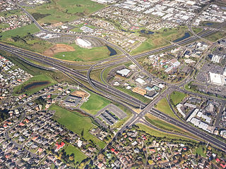
Manukau, or Manukau Central, is a suburb of South Auckland, New Zealand, centred on the Manukau City Centre business district. It is located 23 kilometres south of the Auckland Central Business District, west of the Southern Motorway, south of Papatoetoe, and north of Manurewa. The industrial and commercial suburb of Wiri lies to the east and south.

<span class="mw-page-title-main">Auckland</span> Most populous city in New Zealand

Auckland is a large metropolitan city in the North Island of New Zealand. It has an urban population of about 1,478,800. It is located in the greater Auckland Region, the area governed by Auckland Council, which includes outlying rural areas and the islands of the Hauraki Gulf, and which has a total population of 1,739,300 as of June 2023. It is the most populous city of New Zealand and the fifth largest city in Oceania. While Europeans continue to make up the plurality of Auckland's population, the city became multicultural and cosmopolitan in the late-20th century, with Asians accounting for 31% of the city's population in 2018. Auckland has the fourth largest foreign-born population in the world, with 39% of its residents born overseas. With its large population of Pasifika New Zealanders, the city is also home to the biggest ethnic Polynesian population in the world. The Māori-language name for Auckland is Tāmaki Makaurau, meaning "Tāmaki desired by many", in reference to the desirability of its natural resources and geography. Tāmaki means "omen".

<span class="mw-page-title-main">Papatoetoe (New Zealand electorate)</span> Former electorate in Auckland, New Zealand

Papatoetoe is a former New Zealand parliamentary electorate, and is part of greater Auckland.

<span class="mw-page-title-main">Ōtara</span> Suburb in Auckland, New Zealand

Ōtara is a suburb of South Auckland, New Zealand, situated 18 kilometres to the southeast of the Auckland City Centre. Ōtara lies near the head of the Tamaki River, and is surrounded by the suburbs of Papatoetoe, East Tāmaki, Clover Park and Flat Bush. The area is traditionally part of the rohe of Ngāi Tai ki Tāmaki, and the name Ōtara refers to Ōtara Hill / Te Puke ō Tara, a former Ngāi Tai ki Tāmaki pā and volcanic hill to the north of the suburb. From 1851 to 1910 the area was part of the Goodfellow family farm, and during the 1910s the area was an agricultural college run by the Dilworth Trust.

<span class="mw-page-title-main">Counties Manukau District Health Board</span> District health board in Auckland, New Zealand

The Counties Manukau District Health Board was a district health board which focused on providing healthcare to the Counties Manukau area in southern Auckland, New Zealand. As of 2016, it ws responsible for 534,750 residents; or 11% of New Zealand's population. In July 2022, CM Health was merged into the national health service Te Whatu Ora.

<span class="mw-page-title-main">Māngere East</span> Suburb in Auckland, New Zealand

Māngere East or Mangere East is a suburb of Auckland, New Zealand, under the governance of Auckland Council. It is located to the south of Favona, north of Papatoetoe, west of Middlemore, east of Māngere and Māngere Bridge, and southwest of Ōtāhuhu.

<span class="mw-page-title-main">Manukau ward</span> Ward of Auckland in New Zealand

Manukau Ward is an Auckland Council ward that elects two councillors and covers the Māngere-Ōtāhuhu and Ōtara-Papatoetoe Local Boards. The two councillors are currently Alf Filipaina and Lotu Fuli.

<span class="mw-page-title-main">Ōtara-Papatoetoe Local Board</span> Local board of Auckland Council in New Zealand

The Ōtara-Papatoetoe Local Board is one of the 21 local boards of the Auckland Council. It is overseen by the Manukau ward councillors.

<span class="mw-page-title-main">Ōtara-Papatoetoe</span> Local board area in Auckland, New Zealand

Ōtara-Papatoetoe is a local government area in Auckland, in New Zealand's Auckland Region. It is governed by the Ōtara-Papatoetoe Local Board and Auckland Council. It is within the council's Manukau Ward.

<span class="mw-page-title-main">Pasifika New Zealanders</span> Ethnic group in New Zealand

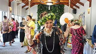
Pasifika New Zealanders are a pan-ethnic group of New Zealanders associated with, and descended from, the indigenous peoples of the Pacific Islands outside of New Zealand itself. They form the fourth-largest ethnic grouping in the country, after European descendants, indigenous Māori, and Asian New Zealanders. Over 380,000 people identify as being of Pacific origin, representing 8% of the country's population, with the majority residing in Auckland.

References

  1. 1 2 "ArcGIS Web Application". statsnz.maps.arcgis.com. Retrieved 1 December 2023.
  2. 1 2 "Population estimate tables - NZ.Stat". Statistics New Zealand . Retrieved 25 October 2023.
  3. 1 2 "Statistical area 1 dataset for 2018 Census". Statistics New Zealand. March 2020. Clover Park North (157700) and Clover Park South (157900).
  4. 2018 Census place summary: Clover Park North
  5. 2018 Census place summary: Clover Park South
  6. Education Counts: Redoubt North School
  7. Education Counts: Kia Aroha College
  8. "Campus History". Kia Aroha College. Retrieved 13 September 2020.
  9. 1 2 3 4 5 6 7 8 "Manukau Sports Bowl draft master plan, revision F" (PDF). Ōtara-Papatoetoe Local Board. 2022. Retrieved 11 June 2024.
  10. 1 2 "Manukau Sports Bowl, Clover Park, 1989". Kura Heritage Collections Online. Auckland Council Libraries. Retrieved 11 June 2024.
  11. "A proud history: the largest Pacific dance festival in the world". ASB Politest. Retrieved 11 June 2024.
  12. "Games velodrome almost finished". The Press . 26 July 1989. p. 27. Retrieved 11 June 2024 via PapersPast.
  13. "Auckland Greyhound Racing Club". Greyhound Racing New Zealand. Retrieved 11 June 2024.
  14. "Top dogs trying for Cup start". The Press . 18 December 1989. p. 38. Retrieved 11 June 2024 via PapersPast.
  15. "SAFE welcomes confirmation of end of greyhound racing at Manukau stadium". RNZ News . 5 December 2023. Retrieved 11 June 2024.