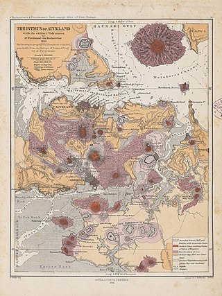
The Auckland volcanic field is an area of monogenetic volcanoes covered by much of the metropolitan area of Auckland, New Zealand's largest city, located in the North Island. The approximately 53 volcanoes in the field have produced a diverse array of maars, tuff rings, scoria cones, and lava flows. With the exception of Rangitoto, no volcano has erupted more than once, but the other eruptions lasted for various periods ranging from a few weeks to several years. Rangitoto erupted several times and recently twice; in an eruption that occurred about 600 years ago, followed by a second eruption approximately 50 years later. The field is fuelled entirely by basaltic magma, unlike the explosive subduction-driven volcanism in the central North Island, such as at Mount Ruapehu and Lake Taupō.

The Panmure Basin, also sometimes known as the Panmure Lagoon, is a tidal estuary within a volcanic crater or maar in New Zealand's Auckland volcanic field. It is located to the south of Panmure town centre.

Tank Farm is the name of a volcanic explosion crater on the North Shore of Auckland, New Zealand, near the approaches to the Auckland Harbour Bridge.

Māngere Lagoon is a lagoon in the Manukau Harbour, New Zealand. It occupies a volcanic crater or maar which is part of the Auckland volcanic field. Oval and about 600m long, it has a small restored scoria island remaining in the centre.

Matukutūreia is one of the volcanic cones in the Auckland volcanic field. It has a peak 73 metres above sea level, and was the site of a pā. The scoria cone was originally crescent-shaped and featured Māori terraces and kumara pits, before extensive quarrying reduced it to a pyramid-shaped mound big enough to support the summit water tank for Papatoetoe. A small part of the summit and the eastern side of the cone were left unquarried, plus a large area of lava flows to the south of the cone remains intact. These remaining parts have recently been transferred to Department of Conservation Management, primarily because of the high heritage values of the Matukuturua Stonefields gardens.

Crater Hill is one of the volcanoes of the Auckland volcanic field, in New Zealand. It consists of an explosion crater about 600 metres (2,000 ft) wide, partly filled with water. The hill, alongside Māngere Lagoon, Waitomokia, Kohuora, Pukaki Lagoon and Robertson Hill, is one of the volcanic features collectively referred to as Nga Tapuwae a Mataoho, referring to the deity in Tāmaki Māori myths who was involved in their creation.

Te Hopua a Rangi, also known as Gloucester Park is one of the volcanoes in the Auckland volcanic field in Auckland, New Zealand, and is located in Onehunga. Its 300 m wide, sediment-filled explosion (maar) crater was used as a boat harbour in early European times and known first as Onehunga Basin then as Geddes Basin. It was reclaimed in the 1930s and named Gloucester Park in 1935 after the visit to New Zealand by the Duke of Gloucester in that year. From 1975 into the early 80's the South-western motorway was built right through the middle of the park and crater. The southern side was turned into a sports ground, and the western side as a wetland with activity space for Aotea Sea Scouts who took ownership of the Manukau Yacht and Motor Boat Club (MYMBC) club house, in 1977.

Waitomokia is a volcano in the Auckland volcanic field. Waitomokia's 600 m (2,000 ft) wide tuff crater contained three small scoria cones up to 20 m (66 ft) high, one with a crater, which were quarried in the 1950s.

Ash Hill is a volcano in Wiri, in the Auckland volcanic field, in New Zealand. A low tuff cone with an explosion crater about 150m wide, it is now covered by industrial development. It peaked at roughly 30 metres above sea level.
Pukaki Lagoon, located in the suburb of Māngere, New Zealand, is one of the volcanoes in the Auckland volcanic field. The lagoon, alongside Māngere Lagoon, Waitomokia, Crater Hill, Kohuora and Robertson Hill, is one of the volcanic features collectively referred to as Nga Tapuwae a Mataoho, referring to the deity in Tāmaki Māori myths who was involved in their creation.

Pukeiti is one of the volcanoes in the Auckland volcanic field. The spatter cone is the smallest volcano in Auckland, reaching 30 metres (98 ft) above sea level, and has a shallow crater over 30 metres (98 ft) wide. The crater rim was quarried on the south and east side. Extensive lava poured out from this vent to form a lava flow field to the north and east. It is now part of the Otuataua Stonefields reserve.
Te Pou Hawaiki is a volcano in the Auckland volcanic field in New Zealand. It was a small, low scoria cone south-east of Mount Eden that was quarried away in the early 20th century.

Ōrākei Basin is one of the volcanoes in the Auckland volcanic field in the North Island of New Zealand. It has an explosion crater around 700 m wide, with a surrounding tuff ring. The present basin is slightly larger than the original maar crater.

Pukewairiki located in Highbrook Park is a volcano in the Auckland volcanic field in the North Island of New Zealand.

Purchas Hill is one of the volcanoes in the Auckland volcanic field.

Robertson Hill is one of the volcanoes in the Auckland volcanic field in New Zealand. It erupted approximately 24,300 years ago. The hill, alongside Māngere Lagoon, Waitomokia, Crater Hill, Kohuora and Pukaki Lagoon, is one of the volcanic features collectively referred to as Nga Tapuwae a Mataoho, referring to the deity in Tāmaki Māori myths who was involved in their creation.

Green Hill is one of the volcanoes in the Auckland volcanic field, located in the suburb of Greenmount. It erupted approximately 20,000 years ago, and its scoria cone had a peak 78 metres above sea level and had a grove of karaka trees. The hill was the site of a Ngāi Tai iwi pā.

Styaks Swamp is one of the volcanoes in the Auckland volcanic field, found in the suburb of East Tāmaki.

Cemetery Crater is one of the volcanoes in the Auckland volcanic field. It is an explosion crater roughly 200 metres (660 ft) wide, located east of Crater Hill. Hard to see even in early aerial photos due to its shallowness, it is now covered by housing.
Mataaho is a Māori deity. Variously considered a god of earthquakes and eruptions, the guardian of the earth's secrets, the god of volcanic forces, or a giant, Mataaho is associated with many of the volcanic features in the Tāmaki Makaurau Region. In traditional Tāmaki Māori myths, Mataaho either creates the volcanic features of the landscape, or requests the gods to create them. Mataaho holds traditional significance for Te Kawerau ā Maki and Waiohua iwi, and is considered a tupuna (ancestor) of Te Ākitai Waiohua iwi.

