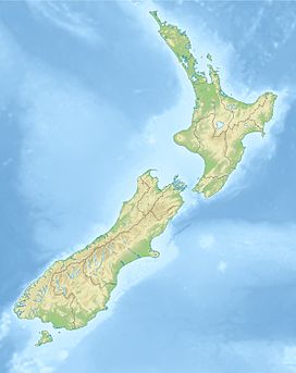
Rangitoto Island is a volcanic island in the Hauraki Gulf near Auckland, New Zealand. The 5.5 km (3.4 mi) wide island is a symmetrical shield volcano cone capped by central scoria cones, reaching a height of 260 m (850 ft). Rangitoto is the youngest and largest of the approximately 50 volcanoes of the Auckland volcanic field, having erupted in two phases about 620 and 600 years ago and covering an area of 2,311 ha. It is separated from the mainland of Auckland's North Shore by the Rangitoto Channel. Since World War II, it has been linked by a causeway to the much older, non-volcanic Motutapu Island.

Cinder Cone is a cinder cone volcano in Lassen Volcanic National Park within the United States. It is located about 10 mi (16 km) northeast of Lassen Peak and provides an excellent view of Brokeoff Mountain, Lassen Peak, and Chaos Crags.

Scoria is a pyroclastic, highly vesicular, dark-colored volcanic rock that was ejected from a volcano as a molten blob and cooled in the air to form discrete grains or clasts. It is typically dark in color, and basaltic or andesitic in composition. Scoria is relatively low in density as a result of its numerous macroscopic ellipsoidal vesicles, but in contrast to pumice, all scoria has a specific gravity greater than 1 and sinks in water.
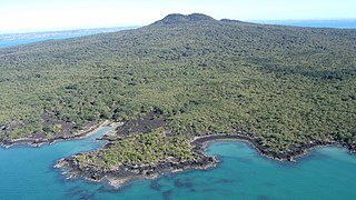
The Auckland volcanic field is an area of monogenetic volcanoes covered by much of the metropolitan area of Auckland, New Zealand's largest city, located in the North Island. The approximately 53 volcanoes in the field have produced a diverse array of maars, tuff rings, scoria cones, and lava flows. With the exception of Rangitoto, no volcano has erupted more than once, but the other eruptions lasted for various periods ranging from a few weeks to several years. Rangitoto erupted several times and recently twice; in an eruption that occurred about 600 years ago, followed by a second eruption approximately 50 years later. The field is fuelled entirely by basaltic magma, unlike the explosive subduction-driven volcanism in the central North Island, such as at Mount Ruapehu and Lake Taupō. The field is currently dormant, but could become active again.

Motukorea or Browns Island is a small New Zealand island, in the Hauraki Gulf north of Musick Point, one of the best preserved volcanoes in the Auckland volcanic field. The age of eruption is about 25,000 years ago, when the Tāmaki Estuary and the Waitemata Harbour were forested river valleys. Due to centuries of cultivation, little native bush remains except on the north-eastern cliffs, leaving the volcanic landforms easily visible. It exhibits the landforms from three styles of eruption. The island consists of one main scoria cone with a deep crater, a small remnant arc of the tuff ring forming the cliffs in the northeast, and the upper portions of lava flows. The area was dry land when the eruptions occurred, but much of the lava is now submerged beneath the sea.
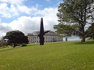
The Auckland Domain, also known as Pukekawa / Auckland Domain, is a large park in Auckland, New Zealand. It is the oldest park in the city, and at 75 hectares is one of the largest. Located in the central suburb of Grafton, the park land is the remains of the explosion crater and most of the surrounding tuff ring of the Pukekawa volcano.

A cinder cone is a steep conical hill of loose pyroclastic fragments, such as volcanic clinkers, volcanic ash, or scoria that has been built around a volcanic vent. The pyroclastic fragments are formed by explosive eruptions or lava fountains from a single, typically cylindrical, vent. As the gas-charged lava is blown violently into the air, it breaks into small fragments that solidify and fall as either cinders, clinkers, or scoria around the vent to form a cone that often is symmetrical; with slopes between 30 and 40°; and a nearly circular ground plan. Most cinder cones have a bowl-shaped crater at the summit.

The volcanism of New Zealand has been responsible for many of the country's geographical features, especially in the North Island and the country's outlying islands.

Mount Smart is one of the volcanoes and Tūpuna Maunga in the Auckland volcanic field. A century of quarrying removed almost all the 87 meter scoria cone along with extensive terracing excavated by Māori. The former quarry is now the site of Mount Smart Stadium.

The geology of New Zealand is noted for its volcanic activity, earthquakes and geothermal areas because of its position on the boundary of the Australian Plate and Pacific Plates. New Zealand is part of Zealandia, a microcontinent nearly half the size of Australia that broke away from the Gondwanan supercontinent about 83 million years ago. New Zealand's early separation from other landmasses and subsequent evolution have created a unique fossil record and modern ecology.

The Auckland Region of New Zealand is built on a basement of greywacke rocks that form many of the islands in the Hauraki Gulf, the Hunua Ranges, and land south of Port Waikato. The Waitākere Ranges in the west are the remains of a large andesitic volcano, and Great Barrier Island was formed by the northern end of the Coromandel Volcanic Zone. The Auckland isthmus and North Shore are composed of Waitemata sandstone and mudstone, and portions of the Northland Allochthon extend as far south as Albany. Little Barrier Island was formed by a relatively isolated andesitic volcano, active around 1 to 3 million years ago.
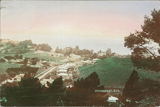
Mount Cambria is one of the volcanoes in the Auckland volcanic field. Located in the suburb of Devonport north-east of Mt Victoria, its 30-metre scoria cone was quarried away. The site is now Cambria Reserve.

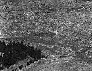
Waitomokia is a volcano in the Auckland volcanic field. Waitomokia's 600 m (2,000 ft) wide tuff crater contained three small scoria cones up to 20 m (66 ft) high, one with a crater, which were quarried in the 1950s.
Te Pou Hawaiki is a volcano in the Auckland volcanic field in New Zealand. It was a small, low scoria cone south-east of Mount Eden that was quarried away in the early 20th century.

Taylors Hill, is a volcano in the Auckland volcanic field. It erupted about 33,000 years ago. Its scoria cone reaches 56 m high.

Purchas Hill is one of the volcanoes in the Auckland volcanic field.
Grafton Volcano is a buried volcano in New Zealand's Auckland volcanic field that underlies much of the Auckland suburb of Grafton. First recognised in 2010, it includes the Outhwaite Park scoria cone that was first mapped by Hochstetter (1864) and inferred by later geologists to be a late phase vent of adjacent Pukekawa Volcano. Borehole drilling and building excavations in the Grafton-Auckland Domain area during the 1990s and 2000s provided new subsurface geological information that allowed geologists to recognise the buried Grafton Volcano.

Te Tātua a Riukiuta / Big King is a volcano and Tūpuna Maunga in Three Kings, New Zealand that erupted 28,500 years ago. The volcano had three prominent peaks known as Three Kings and a number of smaller peaks until most of them were quarried away, leaving a sole remaining large peak known as Big King.

In 1886, a violent eruption occurred at Mount Tarawera, near the city of Rotorua on New Zealand's North Island. At an estimated Volcanic Explosivity Index of 5, the eruption is the largest and deadliest in New Zealand during the past 500 years, which includes the entirety of European history in New Zealand. The eruption began in the early hours of 10 June 1886 and lasted for approximately 6 hours, causing a 10-kilometre-high (6.2 mi) ash column, earthquakes, lightning, and explosions to be heard as far away as Blenheim in the South Island — more than 500 kilometers away. A 17-kilometre-long (11 mi) rift formed across the mountain and surrounding area during the eruption, starting from the Wahanga peak at the mountain's northern end and extending in a southwesterly direction, through Lake Rotomahana and forming the Waimangu Volcanic Rift Valley. This rift is where the basaltic dyke that fed the eruption reached the surface.

The South Auckland volcanic field, also known as the Franklin Volcanic Field, is an area of extinct monogenetic volcanoes around Pukekohe, the Franklin area and north-western Waikato, south of the Auckland volcanic field. The field contains at least 82 volcanoes, which erupted between 550,000 and 1,600,000 years ago.