
The Panmure Basin, also sometimes known as the Panmure Lagoon, is a tidal estuary within a volcanic crater or maar in New Zealand's Auckland volcanic field. It is located to the south of Panmure town centre.

Tank Farm is the name of a volcanic explosion crater on the North Shore of Auckland, New Zealand, near the approaches to the Auckland Harbour Bridge.

Onepoto is the name of a volcanic explosion crater on the North Shore in Auckland, New Zealand. It is a part of the Auckland volcanic field. It should not be confused with Onepoto Hill, which is a volcanic feature of the South Auckland volcanic field.

Mount Smart is one of the volcanoes and Tūpuna Maunga in the Auckland volcanic field. A century of quarrying removed almost all the 87 meter scoria cone along with extensive terracing excavated by Māori. The former quarry is now the site of Mount Smart Stadium.

Crater Hill is one of the volcanoes of the Auckland volcanic field, in New Zealand. It consists of an explosion crater about 600 metres (2,000 ft) wide, partly filled with water. The hill, alongside Māngere Lagoon, Waitomokia, Kohuora, Pukaki Lagoon and Robertson Hill, is one of the volcanic features collectively referred to as Nga Tapuwae a Mataoho, referring to the deity in Tāmaki Māori myths who was involved in their creation.
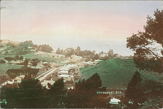
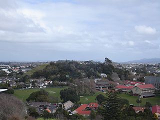
Mount Cambria is one of the volcanoes in the Auckland volcanic field. Located in the suburb of Devonport north-east of Mt Victoria, its 30-metre scoria cone was quarried away. The site is now Cambria Reserve.

Waitomokia is a volcano in the Auckland volcanic field. Waitomokia's 600 m (2,000 ft) wide tuff crater contained three small scoria cones up to 20 m (66 ft) high, one with a crater, which were quarried in the 1950s.

Maungataketake is one of the volcanoes in the Auckland volcanic field in New Zealand. It had a 76 m high scoria cone, beside a 100 m wide crater, before they were quarried away. It was the site of a pā. Layers of volcanic tuff and ash from Maungataketake overlay the fallen trunks of the nearby Ihumātao fossil forest. The New Zealand Ministry for Culture and Heritage gives a translation of "broad mountain" for Maungataketake.
Pukaki Lagoon, located in the suburb of Māngere, New Zealand, is one of the volcanoes in the Auckland volcanic field. The lagoon, alongside Māngere Lagoon, Waitomokia, Crater Hill, Kohuora and Robertson Hill, is one of the volcanic features collectively referred to as Nga Tapuwae a Mataoho, referring to the deity in Tāmaki Māori myths who was involved in their creation.

Pukeiti is one of the volcanoes in the Auckland volcanic field. The spatter cone is the smallest volcano in Auckland, reaching 30 metres (98 ft) above sea level, and has a shallow crater over 30 metres (98 ft) wide. The crater rim was quarried on the south and east side. Extensive lava poured out from this vent to form a lava flow field to the north and east. It is now part of the Otuataua Stonefields reserve.

Duders Hill was a 20 metre high scoria mound located on the Devonport coast, on the lower south-east slopes of Takarunga / Mount Victoria, in the Auckland volcanic field. It was mostly quarried away in the early 20th century
Mount Saint John, is a volcanic scoria cone and Tūpuna Maunga in Epsom, in the Auckland volcanic field of New Zealand.

Taylors Hill, is a volcano in the Auckland volcanic field. It erupted about 33,000 years ago. Its scoria cone reaches 57 m (187 ft) high.

Little Rangitoto, officially known as Maungarāhiri / Little Rangitoto, and also as Rangitoto-iti, is a volcano in the Auckland volcanic field in Remuera, New Zealand. The name Maungarāhiri refers to Rāhiri, an ancestor of Ngāpuhi, who journeyed around the North Island. In the 1700s and early 1800s, the volcano was the site of Ngāti Whātua-o-Ōrākei seasonal farms.

Pukewairiki located in Highbrook Park is a volcano in the Auckland volcanic field in the North Island of New Zealand.

Purchas Hill is one of the volcanoes in the Auckland volcanic field.

Robertson Hill is one of the volcanoes in the Auckland volcanic field in New Zealand. It erupted approximately 24,300 years ago. The hill, alongside Māngere Lagoon, Waitomokia, Crater Hill, Kohuora and Pukaki Lagoon, is one of the volcanic features collectively referred to as Nga Tapuwae a Mataoho, referring to the deity in Tāmaki Māori myths who was involved in their creation.

McLennan Hills is one of the volcanoes in the Auckland volcanic field. It was a group of cratered scoria mounds up to 45 m high, before it was quarried away. A 1940 aerial photo shows a crater around 100 m wide, one around 50 m wide, and 2 or 3 smaller craters. McLennan Hills, alongside neighbouring Ōtāhuhu / Mount Richmond, were the sites of fortified pā in pre-European times, important due to their location between the Waitematā Harbour/Tāmaki River and the Manukau Harbour. Since the European settlement of Auckland, the scoria cone was quarried. The former quarry site was used for greenhouses before being redeveloped for housing.
Kohuora, located in the suburb of Papatoetoe, is one of the volcanoes in the Auckland volcanic field in the North Island of New Zealand.
Grafton Volcano is a buried volcano in New Zealand's Auckland volcanic field that underlies much of the Auckland suburb of Grafton. First recognised in 2010, it includes the Outhwaite Park scoria cone that was first mapped by Hochstetter (1864) and inferred by later geologists to be a late phase vent of adjacent Pukekawa Volcano. Borehole drilling and building excavations in the Grafton-Auckland Domain area during the 1990s and 2000s provided new subsurface geological information that allowed geologists to recognise the buried Grafton Volcano.

