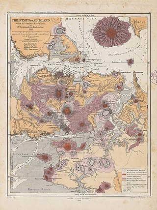
The Auckland volcanic field is an area of monogenetic volcanoes covered by much of the metropolitan area of Auckland, New Zealand's largest city, located in the North Island. The approximately 53 volcanoes in the field have produced a diverse array of maars, tuff rings, scoria cones, and lava flows. With the exception of Rangitoto, no volcano has erupted more than once, but the other eruptions lasted for various periods ranging from a few weeks to several years. Rangitoto erupted several times and recently twice; in an eruption that occurred about 600 years ago, followed by a second eruption approximately 50 years later. The field is fuelled entirely by basaltic magma, unlike the explosive subduction-driven volcanism in the central North Island, such as at Mount Ruapehu and Lake Taupō. The field is currently dormant, but could become active again.

Matukutūreia is one of the volcanic cones in the Auckland volcanic field. It has a peak 73 metres above sea level, and was the site of a pā. The scoria cone was originally crescent-shaped and featured Māori terraces and kumara pits, before extensive quarrying reduced it to a pyramid-shaped mound big enough to support the summit water tank for Papatoetoe. A small part of the summit and the eastern side of the cone were left unquarried, plus a large area of lava flows to the south of the cone remains intact. These remaining parts have recently been transferred to Department of Conservation Management, primarily because of the high heritage values of the Matukuturua Stonefields gardens.
Matukutūruru is a volcano and Tūpuna Maunga in Wiri, in the Auckland volcanic field. It had a scoria cone reaching 80 metres above sea level, which was quarried away. The lava flows created 290m long Wiri Lava Cave. The hill was the site of a pā. In late 2011 the quarry lake was drained and fill-dumping began on the site.
Mount Cambria is one of the volcanoes in the Auckland volcanic field. Located in the suburb of Devonport north-east of Mt Victoria, its 30-metre scoria cone was quarried away. The site is now Cambria Reserve.

Waitomokia is a volcano in the Auckland volcanic field. Waitomokia's 600 m (2,000 ft) wide tuff crater contained three small scoria cones up to 20 m (66 ft) high, one with a crater, which were quarried in the 1950s.

Maungataketake is one of the volcanoes in the Auckland volcanic field in New Zealand. It had a 76 m high scoria cone, beside a 100 m wide crater, before they were quarried away. It was the site of a pā. Layers of volcanic tuff and ash from Maungataketake overlay the fallen trunks of the nearby Ihumātao fossil forest. The New Zealand Ministry for Culture and Heritage gives a translation of "broad mountain" for Maungataketake.
Pukaki Lagoon, located in the suburb of Māngere, New Zealand, is one of the volcanoes in the Auckland volcanic field. The lagoon, alongside Māngere Lagoon, Waitomokia, Crater Hill, Kohuora and Robertson Hill, is one of the volcanic features collectively referred to as Nga Tapuwae a Mataoho, referring to the deity in Tāmaki Māori myths who was involved in their creation.

Pukeiti is one of the volcanoes in the Auckland volcanic field. The spatter cone is the smallest volcano in Auckland, reaching 30 metres (98 ft) above sea level, and has a shallow crater over 30 metres (98 ft) wide. The crater rim was quarried on the south and east side. Extensive lava poured out from this vent to form a lava flow field to the north and east. It is now part of the Otuataua Stonefields reserve.
Te Pou Hawaiki is a volcano in the Auckland volcanic field in New Zealand. It was a small, low scoria cone south-east of Mount Eden that was quarried away in the early 20th century.

Little Rangitoto, officially known as Maungarāhiri / Little Rangitoto, and also as Rangitoto-iti, is a volcano in the Auckland volcanic field in Remuera, New Zealand. The name Maungarāhiri refers to Rāhiri, an ancestor of Ngāpuhi, who journeyed around the North Island. In the 1700s and early 1800s, the volcano was the site of Ngāti Whātua-o-Ōrākei seasonal farms.
Pukewairiki located in Highbrook Park is a volcano in the Auckland volcanic field in the North Island of New Zealand.

Purchas Hill is one of the volcanoes in the Auckland volcanic field.

Robertson Hill is one of the volcanoes in the Auckland volcanic field in New Zealand. It erupted approximately 24,300 years ago. The hill, alongside Māngere Lagoon, Waitomokia, Crater Hill, Kohuora and Pukaki Lagoon, is one of the volcanic features collectively referred to as Nga Tapuwae a Mataoho, referring to the deity in Tāmaki Māori myths who was involved in their creation.

Hampton Park is one of the volcanoes in the Auckland volcanic field. A small scoria cone reaching 35 metres above sea level, with a shallow crater around 50 metres wide, which has been modified by quarrying. The scoria cone sits in the centre of a much larger explosion crater, the eastern arc of the surrounding tuff ring is still present. Stone from the volcano was used to build dry-stone walls and the nearby St John's Church built on the tuff ring crest.

Green Hill is one of the volcanoes in the Auckland volcanic field, located in the suburb of Greenmount. It erupted approximately 20,000 years ago, and its scoria cone had a peak 78 metres above sea level and had a grove of karaka trees. The hill was the site of a Ngāi Tai iwi pā.

Otara Hill is one of the volcanoes in the Auckland volcanic field. Its scoria cone reached 89 m above sea level before it was quarried away. The hill was the site of a pā named “Te Puke Ō Tara” meaning ‘hill belonging to Tara’, who was a Ngāi Tai Rangatira of the area.

Styaks Swamp is one of the volcanoes in the Auckland volcanic field. It erupted approximately 19,600 years ago and formed an explosion crater around 200 metres (660 ft) wide with a surrounding tuff ring. It is located north of Green Hill. The crater once contained a swamp but is now covered by industrial development.

McLennan Hills is one of the volcanoes in the Auckland volcanic field. It was a group of cratered scoria mounds up to 45 m high, before it was quarried away. A 1940 aerial photo shows a crater around 100 m wide, one around 50 m wide, and 2 or 3 smaller craters. McLennan Hills, alongside neighbouring Ōtāhuhu / Mount Richmond, were the sites of fortified pā in pre-European times, important due to their location between the Waitematā Harbour/Tāmaki River and the Manukau Harbour. Since the European settlement of Auckland, the scoria cone was quarried. The former quarry site was used for greenhouses before being redeveloped for housing.

Cemetery Crater is one of the volcanoes in the Auckland volcanic field. It is an explosion crater roughly 200 metres (660 ft) wide, located east of Crater Hill. Hard to see even in early aerial photos due to its shallowness, it is now covered by housing. It was first recognised by Ernie Searle in the 1960s. He named it because of its proximity to the cemetery in Puhinui Rd, but the Southwestern Motorway has now been constructed between the crater and the cemetery.
Kohuora, located in the suburb of Papatoetoe, is one of the volcanoes in the Auckland volcanic field in the North Island of New Zealand.
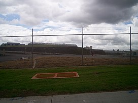
 A piece of Ash Hill, viewed from Oak Road.
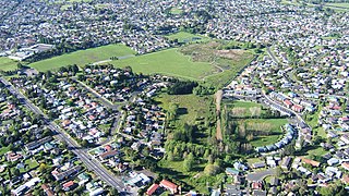
 A view across present day Ash Hill.
 A view of part of Ash Hill before obscuring buildings were removed.


