| Rank | Summit | Landmass | Country | Elevation | Prominence | Isolation | Nearest higher neighbour |
|---|
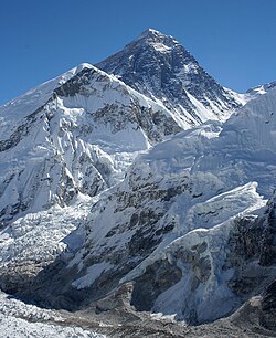
| 1 | Mount Everest | Eurasia |  Nepal Nepal
 China China | 8848 m
29,029 ft | 8848 m
29,029 ft | n/a | n/a |
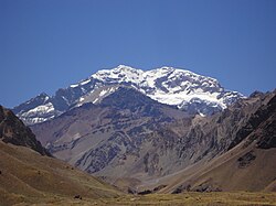
| 2 | Aconcagua | South America |  Argentina (Mendoza) Argentina (Mendoza) | 6962 m
22,841 ft | 6962 m
22,841 ft | 16,520 km
10,265 mi | Tirich Mir (Khyber Pakhtunkhwa, Pakistan) |
| 3 | Denali (Mount McKinley) | North America |  United States (Alaska) United States (Alaska) | 6194 m
20,320 ft | 6149 m
20,174 ft | 7,450 km
4,629 mi | Yanamax (Xinjiang, China) |
| 4 | Kilimanjaro | Africa |  Tanzania Tanzania | 5895 m
19,341 ft | 5885 m
19,308 ft | 5,510 km
3,424 mi | Kuh-e Shashgal (Afghanistan) |
| 5 | Puncak Jaya | New Guinea |  Indonesia (Central Papua) Indonesia (Central Papua) | 4884 m
16,024 ft | 4884 m
16,024 ft | 5,262 km
3,269 mi | Jade Dragon Snow Mountain (Yunnan, China) |
| 6 | Vinson Massif | Antarctica |  Antarctica Antarctica | 4892 m
16,050 ft | 4892 m
16,050 ft | 4,861 km
3,020 mi | Risco Plateado (Mendoza, Argentina) |
| 7 | Mont Orohena | Tahiti |  French Polynesia French Polynesia | 2241 m
7,352 ft | 2241 m
7,352 ft | 4,128 km
2,565 mi | Mount Ngauruhoe (New Zealand) |
| 8 | Mauna Kea | Hawai'i | United States (Hawai'i) | 4205 m
13,796 ft | 4205 m
13,796 ft | 3,947 km
2,453 mi | Mount Shasta (California, US) |
| 9 | Gunnbjørn Fjeld | Greenland |  Greenland Greenland | 3694 m
12,119 ft | 3694 m
12,119 ft | 3,254 km
2,022 mi | The Eiger (Canton of Bern, Switzerland) |
| 10 | Aoraki / Mount Cook | South Island |  New Zealand New Zealand | 3754 m
12,316 ft | 3754 m
12,316 ft | 3,140 km
1,951 mi | Mount Adam (Victoria Land, Antarctica) |
| 11 | Thabana Ntlenyana | Africa |  Lesotho Lesotho | 3482 m
11,424 ft | 2390 m
7,841 ft | 3,003 km
1,866 mi | Mount Meru (Tanzania) |
| 12 | Maunga Terevaka | Easter Island |  Chile Chile | 506 m
1,660 ft | 506 m
1,660 ft | 2,836 km
1,762 mi | Cerro de Los Inocentes (Alejandro Selkirk Island, Chile) |
| 13 | Mont Blanc | Eurasia |  Italy Italy
 France France | 4809 m
15,778 ft | 4696 m
15,407 ft | 2,813 km
1,748 mi | Kukurtlu Dome (Karachay-Cherkessia, Russia) |
| 14 | Piton des Neiges | Réunion | France | 3071 m
10,075 ft | 3071 m
10,075 ft | 2,767 km
1,720 mi | Giant's Castle (KwaZulu-Natal, South Africa) |
| 15 | Klyuchevskaya Sopka | Eurasia |  Russia (Kamchatka) Russia (Kamchatka) | 4750 m
15,584 ft | 4649 m
15,253 ft | 2,748 km
1,708 mi | Mount Foraker (Alaska, US) |
| 16 | Pico de Orizaba | North America |  Mexico (Puebla) Mexico (Puebla) | 5636 m
18,491 ft | 4922 m
16,148 ft | 2,690 km
1,672 mi | Pico Cristóbal Colón (Magdalena Department, Colombia) |
| 17 | Queen Mary's Peak | Tristan da Cunha |  Saint Helena, Ascension and Tristan da Cunha Saint Helena, Ascension and Tristan da Cunha | 2060 m
6,759 ft | 2060 m
6,759 ft | 2,665 km
1,656 mi | Mount Paget (South Georgia Island, UK) |
| 18 | Mount Whitney | North America | United States (California) | 4421 m
14,505 ft | 3072 m
10,080 ft | 2,649 km
1,646 mi | Nevado de Toluca (State of Mexico, Mexico) |
| 19 | Gunung Kinabalu | Borneo |  Malaysia (Sabah) Malaysia (Sabah) | 4095 m
13,435 ft | 4095 m
13,435 ft | 2,538 km
1,577 mi | Ngga Pilimsit (Papua, Indonesia) |
| 20 | Mount Elbrus | Eurasia | Russia (Kabardino-Balkaria) | 5642 m
18,510 ft | 4741 m
15,554 ft | 2,473 km
1,536 mi | Pik Agasis (Tajikistan) |
| 21 | Pico da Bandeira | South America |  Brazil (Espírito Santo) Brazil (Espírito Santo) | 2897 m
9,505 ft | 2647 m
8,684 ft | 2,393 km
1,487 mi | Cerro Naranjos [ es ] (Bolivia) |
| 22 | Mont Cameroun | Africa |  Cameroon Cameroon | 4040 m
13,255 ft | 3901 m
12,799 ft | 2,338 km
1,453 mi | Mikeno (Democratic Republic of the Congo) |
| 23 | Mount Paget | South Georgia |  South Georgia and the South Sandwich Islands South Georgia and the South Sandwich Islands | 2915 m
9,564 ft | 2915 m
9,564 ft | 2,269 km
1,410 mi | Welch Mountains (Palmer Land, Antarctica) |
| 24 | Mauga Silisili | Savai'i |  Samoa Samoa | 1858 m
6,096 ft | 1858 m
6,096 ft | 2,245 km
1,395 mi | Tabwemasana (Vanuatu) |
| 25 | Nevado Huascarán | South America |  Peru Peru | 6746 m
22,133 ft | 2776 m
9,108 ft | 2,196 km
1,365 mi | Tres Cruces (Chile/Argentina border) |
| 26 | Anamudi | Eurasia |  India (Kerala) India (Kerala) | 2695 m
8,842 ft | 2480 m
8,136 ft | 2,115 km
1,314 mi | Machapuchare (Nepal) |
| 27 | Jebel Toubkal | Africa |  Morocco Morocco | 4167 m
13,671 ft | 3755 m
12,320 ft | 2,078 km
1,291 mi | Picco Luigi Amedeo (Italy) |
| 28 | Mount Fuji | Honshu |  Japan (Chūbu) Japan (Chūbu) | 3776 m
12,388 ft | 3776 m
12,388 ft | 2,077 km
1,291 mi | Xueshan (Taiwan) |
| 29 | Emi Koussi | Africa |  Chad Chad | 3445 m
11,302 ft | 2934 m
9,626 ft | 2,001 km
1,243 mi | Mount Cameroon (Cameroon) |
| 30 | Mawson Peak | Heard Island |  Australia (Heard and McDonald Islands) Australia (Heard and McDonald Islands) | 2745 m
9,006 ft | 2745 m
9,006 ft | 1,922 km
1,194 mi | Mount McMaster (Enderby Land, Antarctica) |
| 31 | Mount Mitchell | North America | United States (North Carolina) | 2037 m
6,684 ft | 1857 m
6,091 ft | 1,913 km
1,189 mi | Lone Butte (Colorado, US) |
| 32 | Gunung Kerinci | Sumatra | Indonesia (West Sumatra) | 3805 m
12,484 ft | 3805 m
12,484 ft | 1,905 km
1,184 mi | Gunung Kinabalu (Sabah, Malaysia) |
| 33 | Joe's Hill | Kiritimati |  Kiribati Kiribati | 13 m
43 ft | 13 m
43 ft | 1,903 km
1,182 mi | Puu Ki (Hawaii, US) |
| 34 | Agrihan High Point | Agrihan |  Northern Mariana Islands Northern Mariana Islands | 965 m
3,166 ft | 965 m
3,166 ft | 1,902 km
1,182 mi | Mount Amagi (Chūbu, Japan) |
| 35 | Mount Kosciuszko | Australia | Australia (New South Wales) | 2228 m
7,310 ft | 2228 m
7,310 ft | 1,895 km
1,177 mi | Tutoko (New Zealand) |
| 36 | Olavtoppen | Bouvet Island |  Bouvet Island Bouvet Island | 780 m
2,559 ft | 780 m
2,559 ft | 1,856 km
1,153 mi | Edinburgh Peak (Gough Island, South Atlantic Ocean) |
| 37 | Mascarin Peak | Marion Island |  South Africa (Prince Edward Islands) South Africa (Prince Edward Islands) | 1230 m
4,035 ft | 1230 m
4,035 ft | 1,848 km
1,148 mi | Cockscomb (Eastern Cape, South Africa) |
| 38 | Green Mountain | Ascension Island | Saint Helena, Ascension and Tristan da Cunha | 859 m
2,818 ft | 859 m
2,818 ft | 1,842 km
1,145 mi | Mount Richard-Molard (Ivory Coast/Guinea border) |
| 39 | Gora Narodnaya | Eurasia | Russia (Khanty-Mansi) | 1895 m
6,217 ft | 1772 m
5,814 ft | 1,836 km
1,141 mi | Kattotjåkkå (Sweden) |
| 40 | Yushan | Taiwan |  Taiwan Taiwan | 3952 m
12,966 ft | 3952 m
12,966 ft | 1,815 km
1,128 mi | Peak 4030 (Yunnan, China) |