| Mount Cameroon | |
|---|---|
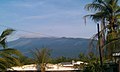
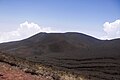
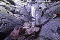
 Mount Cameroon from Buea | |
| Highest point | |
| Elevation | 4,040 m (13,250 ft) [1] [2] |
| Prominence | 3,901 m (12,799 ft) [3] Ranked 31st |
| Isolation | 2,338 km (1,453 mi) |
| Listing | Country high point Ultra, Ribu |
| Coordinates | 4°13′00″N9°10′21″E / 4.21667°N 9.17250°E |
| Naming | |
| Native name | Mongo ma Ndemi (Duala) |
| Geography | |
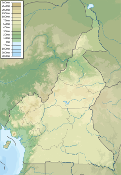 Mount Cameroon Cameroon | |
| Location | Southwest Region, Cameroon |
| Geology | |
| Mountain type | Stratovolcano |
| Last eruption | February 2012 |
| Climbing | |
| First ascent | Joseph Merrick, 1840s [4] |
| Easiest route | Scramble |
Mount Cameroon is an active stratovolcano in the Southwest Region of Cameroon next to the city of Buea near the Gulf of Guinea. Mount Cameroon is also known as Cameroon Mountain or Fako (the name of the higher of its two peaks) or by its indigenous name Mongo ma Ndemi ("Mountain of Greatness"). Mount Cameroon is ranked 22nd by topographic isolation.
Contents
- Geology
- Formation
- Age
- Lava chemistry
- Eruptive history
- Flora
- Fauna
- Mount Cameroon National Park
- IUGS geological heritage site
- Access
- Gallery
- See also
- References
- External links
It is the highest point in sub-Saharan western and central Africa, [5] the fourth-most prominent peak in Africa, and 31st-most prominent in the world. The mountain is part of the area of volcanic activity known as the Cameroon Volcanic Line, which also includes Lake Nyos, the site of a disaster in 1986. The eruption of 28 April-June 1909 caused the German colonial government of Kamerun to temporarily move from Buea to Douala. The most recent eruption occurred on February 3, 2012.