
The Solomon Islands rain forests are a terrestrial ecoregion covering the Solomon Islands archipelago.

Mount Bartle Frere is the highest mountain in Queensland at an elevation of 1,611 metres (5,285 ft). The mountain was named after Sir Henry Bartle Frere, a British colonial administrator and then president of the Royal Geographical Society by George Elphinstone Dalrymple in 1873. Bartle Frere was British Governor of Cape Colony at the outset of the Anglo-Zulu War.

Guinée forestière is a forested mountainous region in southeastern Guinea, extending into northeastern Sierra Leone. It is one of four natural regions into which Guinea is divided and covers 23% of the country. It includes all of the Nzérékoré administrative region, and shares a border with Sierra Leone and Liberia. Its rocky topology contains several mountain ranges and has an average elevation of 460m. Forested Guinea contains important areas of biological diversity such as the UNESCO World Heritage site Mount Nimba Strict Nature Reserve and biosphere reserve Ziama Massif. The Guéckédou prefectures also recorded the initial case of the 2014 Ebola outbreak in Meliandou, a rural village. The virus subsequently spread to urban areas and neighbouring countries Sierra Leone and Liberia.

The Ethiopian Highlands is a rugged mass of mountains in Ethiopia in Northeast Africa. It forms the largest continuous area of its elevation in the continent, with little of its surface falling below 1,500 m (4,900 ft), while the summits reach heights of up to 4,550 m (14,930 ft). It is sometimes called the "Roof of Africa" due to its height and large area. It is the only country in the region with such a high elevated surface. This elevated surface is bisected diagonally by the Great East African Rift System which extends from Syria to Mozambique across the East African Lakes. Most of the Ethiopian Highlands are part of central and northern Ethiopia, and its northernmost portion reaches into Eritrea.
The Viphya Mountains, also known as the Viphya Plateau or Viphya Highlands, are a mountain range in located in Chikangawa in Malawi's Northern Region.

The Black Mountains are a mountain range in western North Carolina, in the southeastern United States. They are part of the Blue Ridge Province of the Southern Appalachian Mountains. The Black Mountains are the highest mountains in the Eastern United States. The range takes its name from the dark appearance of the red spruce and Fraser fir trees that form a spruce-fir forest on the upper slopes which contrasts with the brown or lighter green appearance of the deciduous trees at lower elevations. The Eastern Continental Divide, which runs along the eastern Blue Ridge crest, intersects the southern tip of the Black Mountain range.

Mount Nimba Strict Nature Reserve is a protected area and UNESCO World Heritage Site located in both Guinea and Côte d'Ivoire, extending over a total of area of 175.4 km2, with 125.4 km2 in Guinea, and 50 km2 in Côte d'Ivoire. The reserve covers significant portions of the Nimba Range, a geographically unique area with unusually rich flora and fauna, including exceptional numbers of single-site endemic species, such as Nimbaphrynoides, the Nimba otter shrew, and multiple species of horseshoe bats. Its highest peak is Mount Richard-Molard at 1,752 m (5,750 ft), which is the highest peak of both countries.
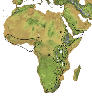
The Afromontane regions are subregions of the Afrotropical realm, one of the Earth's eight biogeographic realms, covering the plant and animal species found in the mountains of Africa and the southern Arabian Peninsula. The Afromontane regions of Africa are discontinuous, separated from each other by lower-lying areas, and are sometimes referred to as the Afromontane archipelago, as their distribution is analogous to a series of sky islands.

Roan Mountain is a 6,277 ft (1,913 m) mountain straddling the North Carolina/Tennessee border in the Unaka Range of the Southern Appalachian Mountains in the Southeastern United States. The range's highpoint, Roan is clad in a dense stand of Southern Appalachian spruce-fir forest, and includes the world's largest natural rhododendron garden, and the longest stretch of grassy bald in the Appalachian range. The Roan Highlands also contain the highest quality remaining stretch of Fraser fir forest throughout the tree's entire range. The Cherokee National Forest and Pisgah National Forest converge atop the mountain, with Roan Mountain State Park located near its northern base. The Appalachian Trail traverses most of the Roan's crest. The Roan High Knob Shelter is the highest back-country shelter on the entire 2,174-mile (3,499 km) trail.

The Cameroonian Highlands forests, also known as the Cameroon Highlands forests, is a montane tropical moist broadleaf forest ecoregion located on the range of mountains that runs inland from the Gulf of Guinea and forms the border between Cameroon and Nigeria. This is an area of forest and grassland which has become more populous as land is cleared for agriculture.

The New Guinea Highlands, also known as the Central Range or Central Cordillera, is a long chain of mountain ranges on the island of New Guinea, including the island's highest peak, Puncak Jaya, Indonesia, 16,024 ft (4,884 m), the highest mountain in Oceania. The range is home to many intermountain river valleys, many of which support thriving agricultural communities. The highlands run generally east-west the length of the island, which is divided politically between Indonesia in the west and Papua New Guinea in the east. These mountains stretch from the Weyland Mountains starting in Wondama Bay Regency in the west to the Milne Bay Province in the east.
The Mount Cameroon and Bioko montane forests is a tropical moist broadleaf forest ecoregion in central Africa. It occupies the upper slopes of coastal Mount Cameroon in Cameroon, and the mountains of nearby Bioko island in Equatorial Guinea.

The Guinea Highlands is a densely forested mountainous plateau extending from central Guinea through northern Sierra Leone and Liberia to western Ivory Coast. The highlands include a number of mountains, ranges and plateaus, including the Fouta Djallon highlands in central Guinea, the Loma Mountains in Sierra Leone, the Simandou and Kourandou massifs in southeastern Guinea, the Nimba Range at the border of Guinea, Liberia, and Ivory Coast, and the Monts du Toura in western Ivory Coast.

The Central Range montane rain forests is a tropical moist forest ecoregion on the island of New Guinea. The ecoregion covers the Central Range of the New Guinea Highlands, which extends along the spine of the island. The montane rain forests of the ecoregion are distinct from the surrounding lowland forests, and are home to many endemic plants and animals.

The Ziama Massif is a forested mountain range and nature reserve in the Nzérékoré Region of south-eastern Guinea.
The Wonegizi Nature Conservation Unit is a proposed nature reserve in Liberia. Proposed in 1987, the site covers an area of 202 km2 (78 sq mi).

The Guinean montane forests are a tropical moist broadleaf forest ecoregion of West Africa.
The Nimba Range forms part of the southern extent of the Guinea Highlands, adjacent to the Toura Mountains. The highest peak is Mount Nimba on the border of Liberia, Ivory Coast and Guinea, at 1,752 m (5,748 ft), and at the intersection of the Nimba and Toura Mountains. "Mount Nimba" may refer either to Mount Richard-Molard or to the entire range. Other peaks include Grand Rochers at 1,694 m (5,558 ft), Mont Sempéré at 1,682 m (5,518 ft), Mont Piérré Richaud at 1,670 m (5,480 ft), Mont Tô at 1,675 m (5,495 ft), and Mont LeClerc 1,577 m (5,174 ft), all of them are located in Guinea. Mount Nimba Strict Nature Reserve of Guinea and Ivory Coast covers significant portions of the Nimba Range.

The Vogelkop montane rain forests is a tropical moist forest ecoregion in western New Guinea. The ecoregion covers the mountains of western New Guinea's Bird's Head and Bomberai peninsulas.
The Wondiboy Peninsula, also known as the Wondiwoi, Wandammen, Wondama, or in old sources Mandamy is a mountainous peninsula in Wondama Bay Regency, Western New Guinea. It extends northwards from the Bird's Neck Isthmus into Cenderawasih Bay, and is composed administratively of the Rasiei, Wondiboy, Wasior and Teluk Duairi Districts (kecamatan) within the regency. At the northern end of the peninsula the land breaks up into a series of islands which form Roon District, of which the largest is Roon Island.
