
Manicaland is a province in eastern Zimbabwe. After Harare Province, it is the country's second-most populous province, with a population of 2.037 million, as of the 2022 census. Making it the third most densely populated province after Harare and Bulawayo provinces. Manicaland was one of five original provinces established in Southern Rhodesia in the early colonial period. The province endowed with country's major tourist attractions, the likes of Mutarazi Falls, Nyanga National Park and Zimbabwe's top three highest peaks. The province is divided into ten administrative subdivisions of seven rural districts and three towns/councils, including the provincial capital, Mutare. The name Manicaland is derived from one of the province's largest ethnic groups, the Manyika, who originate from the area north of the Manicaland province and as well as western Mozambique, who speak a distinct language called ChiManyika in Shona.

Mount Caubvick is a mountain located in Canada on the border between Labrador and Quebec in the Selamiut Range of the Torngat Mountains. It is the highest point in mainland Canada east of the Rockies. The mountain contains a massive peak that rises sharply from nearby sea level. Craggy ridges, steep cirques and glaciers are prominent features of the peak.

The Eastern Highlands, also known as the Manica Highlands, is a mountain range on the border of Zimbabwe and Mozambique. The Eastern Highlands extend north and south for about 300 kilometres (190 mi) through Zimbabwe's Manicaland Province and Mozambique's Manica Province.

Chimanimani, originally known as Melsetter, is a mountainous district in Manicaland Province of eastern Zimbabwe. The district headquarters is the town of Chimanimani.
Chipinge District is a district in Manicaland Province of eastern Zimbabwe. The administrative headquarters is Chipinge.

Crestone Peak is the seventh-highest summit of the Rocky Mountains of North America and the U.S. state of Colorado. The prominent 14,300-foot (4,359 m) fourteener is the highest summit of the Crestones and the second-highest summit in the Sangre de Cristo Range after Blanca Peak. The summit is located in the Sangre de Cristo Wilderness of Rio Grande National Forest, 5.0 miles (8.1 km) east by south of the Town of Crestone in Saguache County, Colorado, United States.

Chimoio is the capital of Manica Province in Mozambique. It is the fifth-largest city in Mozambique.

The North Shore Mountains are a mountain range overlooking Vancouver in British Columbia, Canada. Their southernmost peaks are visible from most areas in Vancouver and form a distinctive backdrop for the city.
Cashel is a village in Chimanimani District of Manicaland Province, Zimbabwe. It is located near the Mozambique border, just north of the Chimanimani Mountains. Forestry, bananas, wheat, and various cash crops are grown in the area. It was originally called Penkridge but was changed to Cashel in 1957. It was named after Lt. Col. E. Cashel, a former member of the British South Africa Police and the Rhodesian Volunteers, who retired to this area after World War I. The Cashel valley is well known for radio and television commercials, which sought to extol the quality of its peas, beans and other agricultural products.

Anthony's Nose is a 900+ ft (270 m) peak in the Hudson Highlands along the east bank of the Hudson River in the hamlet of Cortlandt Manor, New York. It lies at the extreme northwest end of Westchester County, and serves as the east anchor of the Bear Mountain Bridge.

The Bvumba Mountains or Vumba Mountains straddle the Zimbabwe–Mozambique border, and lie some 10 km southeast of the city of Mutare. The Bvumba rise to Castle Beacon at 1,911 metres, and are, together with the Chimanimani Mountains to the south and Nyanga Mountains to the north, part of the Eastern Highlands of the Manicaland and adjacent Manica provinces. They are referred to as the "Mountains of the Mist", as so often the early morning starts with a mist which clears by mid-morning. Although lying mostly within Zimbabwe, the mountains extend north-eastward to Mount Vumba in Mozambique. They are capped by cool, green hills which shelter country hotels, a casino and golf course at the Leopard Rock Hotel and a Botanical Garden with one of the best views in Africa. The mountains are also known for their coffee plantations.

Bimberi Peak or Mount Bimberi with an elevation of 1,913 metres (6,276 ft) located within the Brindabella Ranges is the highest mountain in the Australian Capital Territory (ACT). It is located on the border between New South Wales (NSW) and the ACT, the NSW portion in Kosciuszko National Park and the ACT portion in Namadgi National Park. It is accessible by bush walking trails and requires no specialised climbing skills, although there is no marked trail to the very summit.

Basin Mountain is a mountain in the Great Range of the Adirondacks in the U.S. state of New York. It is the ninth-highest peak in New York, with an elevation of 4,827 feet (1,471 m), and one of the 46 High Peaks in Adirondack Park. It is located in the town of Keene in Essex County. The peak was named either for the basins formed between knobs on its slopes or the large basin to its southeast formed by it and the surrounding mountains. The name Basin was most likely coined by Orson Schofield Phelps and Frederick W. Perkins in 1857 during an ascent of Mount Marcy. The earliest appearance of the name in writing was made by surveyor Verplanck Colvin in 1873.
Olea chimanimani is an olive shrub or small tree, growing 2–3 meters tall, in the family Oleaceae. It is found only in the Chimanimani Mountains, which lay on the border dividing Mozambique and Zimbabwe. Confined only to a relatively small (600 km2) area, it is locally common, growing in scrub vegetation among quartzite cliffs.

Zimbabwe boasts several tourist attractions, located in almost every region of the country. Before the economic changes, much of the tourism for these locations came to the Zimbabwean side but now Zambia benefits from the tourism. The Victoria Falls National Park is also a tourist attraction and is one of the eight main National Parks in Zimbabwe, largest of which is Hwange National Park. Zimbabwe is home to one of the Seven Natural Wonders of the World, the Victoria Falls.

Chimanimani, originally known as Melsetter, is a town in Zimbabwe.
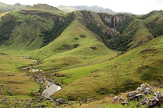
The Chimanimani Mountains are a mountain range on the border of Zimbabwe and Mozambique. The mountains are in the southern portion of the Eastern Highlands, or Manica Highlands, a belt of highlands that extend north and south along the international border, between the Zambezi and Save rivers.
Chimanimani National Park is a protected area next to Chimoio, capital of Manica Province in Mozambique. It is located in the Chimanimani Mountains on the border with Zimbabwe. Together with Zimbabwe's Chimanimani National Park, it forms the Chimanimani Transfrontier Park. It was designated a national reserve in 2003. In 2020 it was designated a national park.

Mount Gorongosa is an inselberg in Sofala Province of central Mozambique. Its highest peak, Gogogo, reaches an elevation of 1,863 meters. It was created by Karoo Volcanism.
Mutare District is a district in Manicaland Province of eastern Zimbabwe. The district headquarters is the city of Mutare.

