
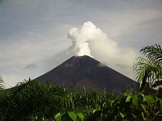
Mount Cameroon is an active volcano in the South West region of Cameroon next to the city of Buea near the Gulf of Guinea. Mount Cameroon is also known as Cameroon Mountain or Fako or by its indigenous name Mongo ma Ndemi. Mount Cameroon is ranked 22nd by topographic isolation.

The Vanuatu rain forests are tropical and subtropical moist broadleaf forests ecoregion which includes the islands of Vanuatu, as well as the Santa Cruz Islands group of the neighboring Solomon Islands. It is part of the Australasian realm, which includes neighboring New Caledonia and the Solomon Islands, as well as Australia, New Guinea, and New Zealand.

The Cross–Sanaga–Bioko coastal forests are a tropical moist broadleaf forest ecoregion of west-central Africa. This is a lush forest, rich in flora and birdlife.

Pico Basilé, located on the island of Bioko, is the tallest mountain of Equatorial Guinea. With an elevation of 9,878 ft, it is the summit of the largest and highest of three overlapping basaltic shield volcanoes which form the island. From the summit, Mt. Cameroon can be seen to the northeast. Pico Basilé lies close to the city of Malabo. The very top is used as a broadcast transmitting station for RTVGE and microwave relay station for various communication networks.

The Cameroon line is a 1,600 km (1,000 mi) long chain of volcanoes that includes islands in the Gulf of Guinea and mountains on the African mainland, from Mount Cameroon on the coast towards Lake Chad on the northeast. They form a natural border between eastern Nigeria and the West Region of Cameroon. The islands, which span the equator, have tropical climates and are home to many unique plant and bird species. The mainland mountain regions are much cooler than the surrounding lowlands, and also contain unique and ecologically important environments.

The São Tomé, Príncipe, and Annobón forests, also known as the São Tomé, Príncipe, and Annobón moist lowland forests, is a tropical moist broadleaf forest ecoregion that covers the islands of São Tomé and Príncipe, which form the island nation of São Tomé and Príncipe, as well as the island of Annobón, which is part of Equatorial Guinea.

The Cameroonian Highlands forests, also known as the Cameroon Highlands forests, are a montane tropical moist broadleaf forest ecoregion located on the range of mountains that runs inland from the Gulf of Guinea and forms the border between Cameroon and Nigeria. This is an area of forest and grassland which has become more populous as land is cleared for agriculture.

The Fernando Po speirops, also known as the Bioko speirops, is a species of bird in the family Zosteropidae. It is endemic to Bioko Island in Equatorial Guinea.

The wildlife of São Tomé and Príncipe is composed of its flora and fauna. São Tomé and Príncipe are oceanic islands which have always been separate from mainland West Africa and so there is a relatively low diversity of species, restricted to those that have managed to cross the sea to the islands. However the level of endemism is high with many species occurring nowhere else in the world.

The Atlantic Equatorial coastal forests, also known as the Congolian coastal forests, are a tropical moist broadleaf forest ecoregion of Central Africa, covering hills, plains, and mountains of the Atlantic coast of Cameroon, Equatorial Guinea, Gabon, Republic of the Congo, Angola, and Democratic Republic of the Congo.

The Lesser Sundas deciduous forests is a tropical dry forest ecoregion in Indonesia. The ecoregion includes the islands of Lombok, Sumbawa, Komodo, Flores, and Alor, along with the many adjacent smaller islands.

The Borneo montane rain forests is an ecoregion on the island of Borneo in Southeast Asia. It includes montane tropical and subtropical moist broadleaf forests, also known as a cloud forests. The ecoregion is partly in East Malaysia and Indonesia (Kalimantan).

The East African montane moorlands is a montane grasslands and shrublands ecoregion which occupies several high mountain peaks in Kenya, South Sudan, Tanzania, and Uganda.

The Guinean montane forests are a tropical moist broadleaf forest ecoregion of West Africa.

The Peninsular Malaysian montane rain forests is an ecoregion on the Malay Peninsula. It occupies the mountainous spine of the peninsula in Malaysia and southernmost Thailand. It is in the tropical and subtropical moist broadleaf forests biome.

The Vogelkop montane rain forests is a tropical moist forest ecoregion in western New Guinea. The ecoregion covers the mountains of western New Guinea's Bird's Head and Bomberai peninsulas.
The New Britain–New Ireland montane rain forests is a tropical moist forest ecoregion in Papua New Guinea. The ecoregion includes the mountain rain forests on the islands of New Britain and New Ireland, which lie northeast of New Guinea.

The Northern New Guinea montane rain forests is a tropical moist forest ecoregion in northern New Guinea. The ecoregion covers several separate mountain ranges lying north of New Guinea's Central Range and south of the Pacific Ocean.

The Southeastern Papuan rain forests is a tropical moist forest ecoregion in southeastern New Guinea. The ecoregion covers the mountainous center and coastal lowlands of the Papuan Peninsula.

The Southern New Guinea lowland rain forests is a tropical moist forest ecoregion in southeastern New Guinea. The ecoregion covers portions of New Guinea's southern lowlands.

