
Mont Blanc is the highest mountain in the Alps and Western Europe, and the highest mountain in Europe outside the Caucasus Mountains, rising 4,805.59 m (15,766 ft) above sea level, located on the Franco-Italian border. It is the second-most prominent mountain in Europe, after Mount Elbrus, and the 11th most prominent mountain in the world.
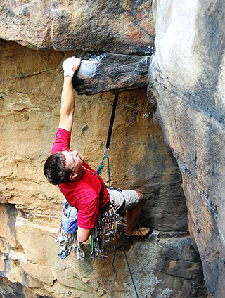
Traditional climbing is a type of free climbing in rock climbing where the lead climber places the protection equipment while ascending the route; when the lead climber has completed the route, the second climber then removes the protection equipment as they climb the route. Traditional climbing differs from sport climbing where the protection equipment is pre-drilled into the rock in the form of bolts.

Aconcagua is a mountain in the Principal Cordillera of the Andes mountain range, in Mendoza Province, Argentina. It is the highest mountain in the Americas, the highest outside Asia, and the highest in both the Western Hemisphere and the Southern Hemisphere with a summit elevation of 6,961 metres (22,838 ft). Despite its impressive size and stature, it is only the 189th highest mountain in the world. It lies 112 kilometres northwest of the provincial capital, the city of Mendoza, about five kilometres from San Juan Province, and 15 km (9 mi) from Argentina's border with Chile. The mountain is one of the Seven Summits of the seven continents.

A climbing route is a path by which a climber reaches the top of a mountain, a rock face or an ice-covered obstacle. The details of a climbing route are recorded in a climbing guidebook and/or in an online climbing-route database. Details recorded will include elements such as the type of climbing route, the difficulty grade of the route–and beta on its crux(es)–and any risk or commitment grade, the length and number of pitches of the route, and the climbing equipment that is needed to complete the route.

Mount Robson is the most prominent mountain in North America's Rocky Mountain range; it is also the highest point in the Canadian Rockies. The mountain is located entirely within Mount Robson Provincial Park of British Columbia, and is part of the Rainbow Range. Mount Robson is the second highest peak entirely in British Columbia, behind Mount Waddington in the Coast Range. The south face of Mount Robson is clearly visible from the Yellowhead Highway, and is commonly photographed along this route.

Gasherbrum II ; surveyed as K4, is the 13th highest mountain in the world at 8,035 metres (26,362 ft) above sea level. It is the third-highest peak of the Gasherbrum massif, and is located in the Karakoram, on the border between Gilgit–Baltistan, Pakistan and Xinjiang, China. The mountain was first climbed on July 7, 1956, by an Austrian expedition which included Fritz Moravec, Josef Larch, and Hans Willenpart.

Mount Forbes is the seventh tallest mountain in the Canadian Rockies and the tallest within the boundaries of Banff National Park. It is located in southwestern Alberta, 18 km (11 mi) southwest of the Saskatchewan River Crossing in Banff. The mountain was named by James Hector in 1859 after Edward Forbes, Hector's natural history professor at the University of Edinburgh during the mid-19th century.

Solo climbing, or soloing, is a style of climbing in which the climber climbs a route alone, without the assistance of a belayer or being part of a rope team. By its very nature, solo climbing presents a higher degree of risk to the climber, and in some cases, particularly where the climber is also not using any form of climbing protection, it is considered an extremely high-risk activity.

Grand Teton is the highest mountain of the Teton Range in Grand Teton National Park at 13,775 feet (4,199 m) in Northwest Wyoming. Below its north face is Teton Glacier. The mountain is a classic destination in American mountaineering via the Owen-Spalding route, the North Ridge and North Face.

Toubkal, also Jbel Toubkal or Jebel Toubkal, is a mountain in southwestern Morocco, located in the Toubkal National Park. At 4,167 m (13,671 ft), it is the highest peak in Morocco, the Atlas Mountains, North Africa and the Arab world. Located 63 km (39 mi) south of the city of Marrakesh, and visible from it, Toubkal is an ultra prominent peak, the highest for over 2,000 km (1,200 mi). Toubkal is ranked 27th by topographic isolation.

Huascarán, Nevado Huascarán or Mataraju is a mountain located in Yungay Province, Department of Ancash, Peru. It is situated in the Cordillera Blanca range of the western Andes. The southern summit of Huascarán, which reaches 6,768 metres (22,205 ft), is the highest point in Peru, the northern Andes, and in all of the earth's Tropics. Huascarán is the 4th highest mountain in South America after Aconcagua, Ojos del Salado, and Monte Pissis. Huascarán is ranked 25th by topographic isolation.

The Vignemale, at 3,298 metres, is the highest of the French Pyrenean summits. It lies on the border between the Department of Hautes-Pyrénées, in Occitanie and Gascony, France and Sobrarbe, in Huesca, Aragon, Spain, and the peak is split between the two countries.

The Pic du Midi d'Ossau is a mountain rising above the Ossau Valley in the French Pyrenees. Despite possessing neither a glacier nor, in the context of the range, a particularly high summit, its distinctive shape makes it a symbol of the French side of the Pyrenees. This familiar shape also makes it easily recognisable from afar, and it is particularly distinctive from the Boulevard des Pyrénées in Pau, some 55 km to the north.

Rope-solo climbing or rope-soloing is a form of solo climbing, but unlike with free solo climbing, which is also performed alone and with no climbing protection whatsoever, the rope-solo climber uses a mechanical self-belay device and rope system, which enables them to use the standard climbing protection to protect themselves in the event of a fall.
Wojciech Kurtyka is a Polish mountaineer and rock climber, one of the pioneers of the alpine style of climbing the biggest walls in the Greater Ranges. He lived in Wrocław up to 1974 when he moved to Kraków. He graduated as engineer in electronics. In 1985 he climbed the "Shining Wall," the west face of Gasherbrum IV, which Climbing magazine declared to be the greatest achievement of mountaineering in the twentieth century. In 2016, he received the Piolet d'Or for lifetime achievement in mountaineering.

The Aiguille du Tour is a mountain in the Mont Blanc massif, located on the border between Switzerland and France. The voie normale on the mountain is graded F (facile) and can be climbed from either the Albert Premier Hut on the French side or the Trient Hut on the Swiss side.

Big wall climbing is a form of rock climbing that takes place on long multi-pitch routes that normally require a full day, if not several days, to ascend. In addition, big wall routes are typically sustained and exposed, where the climbers remain suspended from the rock face, even sleeping hanging from the face, with limited options to sit down or escape unless they abseil back down the whole route, which is a complex and risky action. It is therefore a physically and mentally demanding form of climbing.

Catherine Destivelle is a French rock climber and mountaineer who is considered one of the greatest and most important female climbers in the history of the sport. She came to prominence in the mid-1980s for sport climbing by winning the first major female climbing competitions, and by being the first female to redpoint a 7c+/8a sport climbing route with Fleur de Rocaille in 1985, and an 8a+ (5.13c) route with Choucas in 1988. During this period, she was considered the strongest female sport climber in the world along with Lynn Hill, however, in 1990 she retired to focus on alpine climbing.
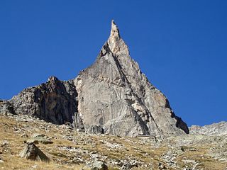
The Aiguille Dibona, formerly called (Aiguille du) Pain de Sucre du Soreiller, is a mountain in the Massif des Écrins in the French Alps notable for its "astonishing triangular granite spear."
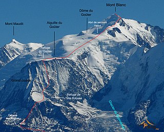
The Goûter Route is one of the two normal mountaineering routes used to reach the summit of Mont Blanc in the Alps, ascending to a height of 4,808 metres (15,774 ft). The route lies on the north side of the mountain, in France. Usually reckoned as the easiest route up Mont Blanc, it is extremely popular with mountaineers, seeing thousands of ascents per year.
