
The Andes or Andean Mountains are the longest continental mountain range in the world, forming a continuous highland along the western edge of South America. This range is about 7,000 km (4,300 mi) long, about 200 to 700 km wide, and of an average height of about 4,000 m (13,000 ft). The Andes extend from north to south through seven South American countries: Venezuela, Colombia, Ecuador, Peru, Bolivia, Chile and Argentina.

Mount Everest, known in Nepali as Sagarmatha (सगरमाथा) and in Tibetan as Chomolungma (ཇོ་མོ་གླང་མ), is Earth's highest mountain above sea level, located in the Mahalangur Himal sub-range of the Himalayas. The international border between Nepal and China runs across its summit point.

Mont Blanc, meaning "White Mountain", is the highest mountain in the Alps and the highest in Europe west of Russia's Caucasus peaks. It rises 4,808.7 m (15,777 ft) above sea level and is ranked 11th in the world in topographic prominence. The mountain stands in a range called the Graian Alps, between the regions of Aosta Valley, Italy, and Savoie and Haute-Savoie, France. The location of the summit is on the watershed line between the valleys of Ferret and Veny in Italy and the valleys of Montjoie, and Arve in France, in the middle of what is generally considered to be the border between the two countries.

Aconcagua, with a summit elevation of 6,960.8 metres (22,837 ft), is the highest mountain in both the Southern and Western Hemispheres. It is located in the Andes mountain range, in the Mendoza Province, Argentina, and lies 112 km (70 mi) northwest of its capital, the city of Mendoza, about five km (3.1 mi) from San Juan Province and 15 km (9.3 mi) from the international border with Chile. The mountain itself lies entirely within Argentina, immediately east of Argentina's border with Chile. Its nearest higher neighbor is Tirich Mir in the Hindu Kush, 16,520 kilometres (10,270 mi) away. It is one of the Seven Summits.

The Maya Mountains are a mountain range located in Belize and eastern Guatemala, in Central America.

The Angeles National Forest (ANF) of the U.S. Forest Service is located in the San Gabriel Mountains and Sierra Pelona Mountains, primarily within Los Angeles County in southern California. The ANF manages a majority of the San Gabriel Mountains National Monument.

These are lists of mountains and mountain ranges in Ireland. Those within Northern Ireland, or on the border, are marked with an asterisk, while the rest are within the Republic of Ireland. Where mountains are ranked by height, the definition of the "topographical prominence", used to classify the mountain, is noted. In British definitions, a height of 600 metres (1,969 ft) is required for a "mountain", whereas in Ireland, a lower threshold of 500 metres (1,640 ft) is sometimes advocated.
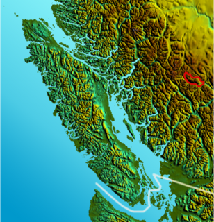
The Dickson Range is a subrange of the Chilcotin Ranges subset of the Pacific Ranges of the Coast Mountains in southwest-central British Columbia. It is located just west of the town of Gold Bridge between the valley of Slim Creek to the north and Downton Lake Reservoir to the south. At its eastern foot is Gun Lake; its western limit is at a pass between Slim Creek and Nichols Creek near the pass which separates the Bridge River basin from that of the Lord River, which feeds the Taseko Lakes.

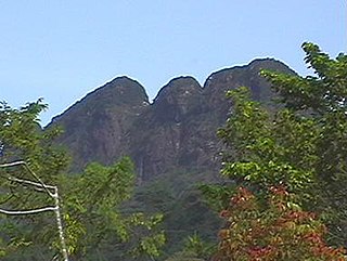
Doyle's Delight is the highest peak in Belize at 1,124 m (3,688 ft). It lies in the Cockscomb Range, a spur of the Maya Mountains in Western Belize.
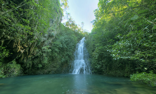
The Cockscomb Basin Wildlife Sanctuary is a nature reserve in the Stann Creek District of south-central Belize. It was established to protect the forests, fauna and watersheds of an approximately 400 square kilometres (150 sq mi) area of the eastern slopes of the Maya Mountains.
Victoria Peak within the Maya Mountains is the second highest mountain in Belize. The highest peak in the country, Doyle's Delight at a height of 1,124 metres (3,688 ft), is located 57 kilometres (35 mi) southwest of Victoria Peak. Victoria Peak is situated in the Cockscomb Basin Wildlife Sanctuary. Victoria Peak is situated in the Stann Creek District of Belize, in the Cockscomb Basin Wildlife Sanctuary, and is home to many flora and fauna common to Belize. It was pronounced a natural monument in 1998, comprising about 4,847 acres bordered by the Sittee River Forest Reserve, Cockscomb Basin Wildlife Sanctuary, and Chiquibul National Park.
The Hewitt's ghost frog is a species of frog in the Heleophrynidae family. It is endemic to Eastern Cape Province, South Africa. Its natural habitat is fynbos heathland and grassy fynbos. Adults are difficult to see but live in or near fast-flowing perennial rivers and streams where they also breed. Each female lays up to 200 eggs. Tadpoles are more readily seen and take two years to develop fully.
Cockscomb Buttress is a prominent, isolated rock buttress rising to 465 metres (1,530 ft), standing 1 nautical mile (2 km) northwest of Echo Mountain and overlooking the east side of Norway Bight on the south coast of Coronation Island, in the South Orkney Islands. The name, which is descriptive, was given by the Falkland Islands Dependencies Survey following their survey of 1950.

Hagues Peak is the highest summit of the Mummy Range in the Rocky Mountains of North America. The 13,573-foot (4,137 m) thirteener is located in the Rocky Mountain National Park Wilderness, 9.9 miles (15.9 km) northwest of the Town of Estes Park, Colorado, United States. The summit of Hagues Peak is the highest point in Larimer County, Colorado.

For the mountain in California formerly named Summit Peak, see Mount Ina Coolbrith.

Mount Jizhen is the second highest mountain in Guangzhou, China, with an altitude of 1,175 metres (3,855 ft), just 35 meters lower than Tiantang Peak.

Eglinton Fiord is a fjord on Baffin Island's northeastern coast in the Qikiqtaaluk Region of Nunavut, Canada. The Inuit settlement of Pond Inlet is 355 km (221 mi) to the northwest and Clyde River is 55 km (34 mi) to the east.
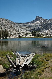
Cockscomb is a mountain, in the area of Tuolumne Meadows, Yosemite National Park, California.


