Patensie

Last updated

Patensie
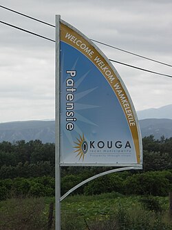
Kouga-Patensie signboard-001.JPG
Signboard on the R331 outside Patensie
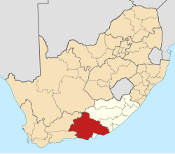
South Africa Eastern Cape location map.svg
Red pog.svg
Patensie
South Africa adm location map.svg
Red pog.svg
Patensie
Coordinates: 33°45′32″S24°48′53″E / 33.75889°S 24.81472°E / -33.75889; 24.81472
Country South Africa
Province Eastern Cape
District Sarah Baartman
Municipality Kouga
Established1858 [1]
Area
[2]
  Total6.23 km2 (2.41 sq mi)
Population
 (2011) [2]
  Total5,263
  Density840/km2 (2,200/sq mi)
Racial makeup (2011)
[2]
   Black African 39.7%
   Coloured 50.2%
   Indian/Asian 0.2%
   White 8.0%
  Other1.9%
First languages (2011)
[2]
   Afrikaans 70.0%
   Xhosa 24.9%
   English 1.4%
  Other3.7%
Time zone UTC+2 (SAST)
Postal code (street)
6335
PO box
6335
Area code 042
Websitewww.patensie-is-lekker.co.za

Patensie is a town in Sarah Baartman District Municipality in the Eastern Cape province of South Africa. Patensie lies along the R331 road just south of Noorshoek. The Kouga Dam is located several kilometres to the west. The name is Khoi in origin, and means "cattle resting place". [3] The town is a centre for the citrus, tobacco, and vegetable farms in the area. [3]

Related Research Articles

<span class="mw-page-title-main">Cape Town</span> Legislative capital of South Africa

Cape Town is the legislative capital of South Africa. It is the country's oldest city and the seat of the Parliament of South Africa. It is the country's second-largest city, after Johannesburg, and the largest in the Western Cape. The city is part of the City of Cape Town metropolitan municipality.

<span class="mw-page-title-main">Winchester</span> City in Hampshire, England

Winchester is a cathedral city in Hampshire, England. The city lies at the heart of the wider City of Winchester, a local government district, at the western end of the South Downs National Park, on the River Itchen. It is 60 miles (97 km) south-west of London and 14 miles (23 km) from Southampton, its nearest city. At the 2011 census, Winchester had a population of 45,184. The wider City of Winchester district, which includes towns such as Alresford and Bishop's Waltham, has a population of 116,595. Winchester is the county town of Hampshire and contains the head offices of Hampshire County Council.

<span class="mw-page-title-main">Gloucestershire</span> County of England

Gloucestershire is a ceremonial county in South West England. It is bordered by Herefordshire to the north-west, Worcestershire to the north, Warwickshire to the north-east, Oxfordshire to the east, Wiltshire to the south, Bristol and Somerset to the south-west, and the Welsh county of Monmouthshire to the west. The city of Gloucester is the largest settlement and the county town.

<span class="mw-page-title-main">Harrogate</span> Town in North Yorkshire, England

Harrogate is a spa town in the district and county of North Yorkshire, England. Historically in the West Riding of Yorkshire, the town is a tourist destination and its visitor attractions include its spa waters and RHS Harlow Carr gardens. 13 miles (21 km) away from the town centre is the Yorkshire Dales National Park and the Nidderdale AONB.

The National League is an association football league in England consisting of three divisions, the National League, National League North, and National League South. It was called the "Alliance Premier League" from 1979 until 1986. Between 1986 and 2015, the league was known as the "Football Conference".

<span class="mw-page-title-main">Basingstoke</span> Town in England

Basingstoke is a town in Hampshire, situated in south-central England across a valley at the source of the River Loddon on the western edge of the North Downs. It is the largest settlement in Hampshire without city status. It is located 30 miles (48 km) north-east of Southampton, 48 miles (77 km) south-west of London, 27 miles (43 km) west of Guildford, 22 miles (35 km) south of Reading and 20 miles (32 km) north-east of the county town and former capital Winchester. According to the 2016 population estimate, the town had a population of 113,776. It is part of the borough of Basingstoke and Deane and part of the parliamentary constituency of Basingstoke.

<span class="mw-page-title-main">Loughborough</span> Town in Charnwood, Leicestershire, England

Loughborough is a market town in the Charnwood borough of Leicestershire, England, the seat of Charnwood Borough Council and Loughborough University. At the 2021 census the town's built-up area, including Shepshed, had a population of 109,100, the second largest in the county after Leicester. It is close to the Nottinghamshire border and short distances from Leicester, Nottingham, East Midlands Airport and Derby. It has the world's largest bell foundry, John Taylor Bellfounders, which made bells for the Carillon War Memorial, a landmark in the Queens Park in the town, of Great Paul for St Paul's Cathedral, and for York Minster.

The National League South, formerly Conference South, is one of the second divisions of the National League in England, immediately below the top division National League. Along with National League North, it is in the second level of the National League System, and is the sixth tier overall of the English football league system, and includes teams from the South East, London, and the South West, as well as teams from Essex.

<span class="mw-page-title-main">Immingham</span> Town and civil parish in Lincolnshire, England

Immingham is a town and civil parish in North East Lincolnshire, in Lincolnshire, England. It is situated on the south-west bank of the Humber Estuary, and is six miles northwest of Grimsby.

<span class="mw-page-title-main">Gamtoos River</span> River in the Eastern Cape, South Africa

Gamtoos River or Gamptoos River is a river in the Eastern Cape Province, South Africa. It is formed by the confluence of the Kouga River and the Groot River and is approximately 645-kilometre (401 mi) long with a catchment area of 34,635 square kilometres (13,373 sq mi).

<span class="mw-page-title-main">Observatory, Cape Town</span> Place in Western Cape, South Africa

Observatory is a suburb in Cape Town, South Africa, colloquially known as Obs. Bordered by Mowbray to the south and Salt River to the northwest, the area is best known as a student neighbourhood associated with the nearby University of Cape Town and Groote Schuur Hospital. It takes its name from the South African Astronomical Observatory headquarters, built in 1829 by the Royal Observatory.

<span class="mw-page-title-main">Kouga Dam</span> Dam in Eastern Cape Province, South Africa

The Kouga Dam is an arch dam on the Kouga River about 21 km (13 mi) west of Patensie in Kouga Local Municipality, South Africa. It supplies irrigation water to the Kouga and Gamtoos valleys as well as drinking water to the Port Elizabeth metropolitan area via the Loerie Balancing Dam. It was constructed between 1957 and 1969.

<i>Haworthiopsis fasciata</i> Species of succulent

Haworthiopsis fasciata, formerly Haworthia fasciata, is a species of succulent plant from the Eastern Cape Province, South Africa. The species is rare in cultivation; most plants that are labelled as H. fasciata are actually Haworthiopsis attenuata.

<span class="mw-page-title-main">Avontuur Railway</span> Railway line in South Africa

The Avontuur Railway is a closed railway line between Port Elizabeth and the town of Avontuur in the Western and Eastern Cape provinces of South Africa. It is the longest 610 mm narrow gauge route in the world at a length of 285 kilometres (177 mi). "Avontuur" is the Afrikaans and Dutch word for "adventure".

<span class="mw-page-title-main">Kouga Local Municipality</span> Local municipality in Eastern Cape, South Africa

Kouga Municipality is a local municipality in the Eastern Cape of South Africa, approximately 80 km west of Gqebera. It forms part of the Sarah Baartman District Municipality. Its territory includes the coastal zone between the Van Stadens River in the east and the Tsitsikamma River in the west, and stretches inland towards the Baviaanskloof Mountains in the north.

<i>Strelitzia juncea</i> Species of flowering plant

Strelitzia juncea, the rush-leaved strelitzia or narrow-leaved bird of paradise, is a monocotyledonous flowering plant that is indigenous to South Africa. This drought-resistant Strelitzia occurs sparingly near Uitenhage, Patensie and just north of Port Elizabeth. It is threatened in part by illegal removal for horticultural purposes. This species is thought to be one of the most frost-resistant of the genus Strelitzia.

<span class="mw-page-title-main">Cockscomb (mountain)</span>

The Cockscomb is a high mountain in the Eastern Cape, in South Africa. It gets its name from its resemblance to a fowl's comb. It is situated in the Baviaanskloof region and the nearest town is Patensie. The Cockscomb is part of the Groot Winterhoek range. Its peak is 1,768 m (5,801 ft) or 1,752 m (5,748 ft) above sea level, depending on the source.

Kevin Ash was a British motorcycle journalist and author, who contributed to The Daily Telegraph and to Motor Cycle News.

<span class="mw-page-title-main">Ultra South Africa</span> Electronic music festival

Ultra South Africa is Africa's largest electronic music festival and is part of Ultra Music Festival's worldwide expansion which has now spread to twenty countries. Ultra South Africa is a single day event taking place in two cities. Having debuted in 2014, Ultra South Africa is one of the longest standing world editions of the festival. Ultra South Africa is a strictly 18 and over event.

References

  1. "Patensie". Gamtoos Tourism. Retrieved 25 February 2012.
  2. 1 2 3 4 "Main Place Patensie". Census 2011.
  3. 1 2 "Cacadu Region". Revealed.co.za. Archived from the original on 3 September 2014. Retrieved 28 August 2014.