"},"population_total":{"wt":"214"},"population_as_of":{"wt":"2011"},"population_density_km2":{"wt":"auto\n"},"demographics_type1":{"wt":"Racial makeup (2011)"},"demographics1_footnotes":{"wt":""},"demographics1_title1":{"wt":"[[Bantu peoples of South Africa|Black African]]"},"demographics1_info1":{"wt":"10.7%"},"demographics1_title2":{"wt":"[[Coloureds|Coloured]]"},"demographics1_info2":{"wt":"0.5%"},"demographics1_title3":{"wt":"[[Indian South African|Indian]]/[[Asian South African|Asian]]"},"demographics1_info3":{"wt":"0.9%"},"demographics1_title4":{"wt":"[[White South African|White]]"},"demographics1_info4":{"wt":"87.9%"},"demographics1_title5":{"wt":"Other"},"demographics1_info5":{"wt":""},"demographics_type2":{"wt":"[[First language]]s (2011)"},"demographics2_footnotes":{"wt":""},"demographics2_title1":{"wt":"[[South African English|English]]"},"demographics2_info1":{"wt":"52.3%"},"demographics2_title2":{"wt":"[[Afrikaans]]"},"demographics2_info2":{"wt":"44.4%"},"demographics2_title3":{"wt":"[[Xhosa language|Xhosa]]"},"demographics2_info3":{"wt":"1.4%"},"demographics2_title4":{"wt":""},"demographics2_info4":{"wt":""},"demographics2_title5":{"wt":"Other"},"demographics2_info5":{"wt":"1.9%\n\n"},"timezone1":{"wt":"[[South African Standard Time|SAST]]"},"utc_offset1":{"wt":"+2"},"postal_code_type":{"wt":"[[List of postal codes in South Africa|Postal code]] (street)"},"postal_code":{"wt":""},"postal2_code_type":{"wt":"[[Post-office box|PO box]]"},"postal2_code":{"wt":"6186"},"area_code_type":{"wt":"[[Telephone numbers in South Africa|Area code]]"}},"i":0}}]}" id="mwCQ">Place in Eastern Cape, South Africa
Cannon Rocks | |
---|---|
Coordinates: 33°45′S26°33′E / 33.750°S 26.550°E | |
Country | South Africa |
Province | Eastern Cape |
District | Sarah Baartman |
Municipality | Ndlambe |
Area | |
• Total | 3.12 km2 (1.20 sq mi) |
Population (2011) [1] | |
• Total | 214 |
• Density | 69/km2 (180/sq mi) |
Racial makeup (2011) | |
• Black African | 10.7% |
• Coloured | 0.5% |
• Indian/Asian | 0.9% |
• White | 87.9% |
First languages (2011) | |
• English | 52.3% |
• Afrikaans | 44.4% |
• Xhosa | 1.4% |
• Other | 1.9% |
Time zone | UTC+2 (SAST) |
PO box | 6186 |
Cannon Rocks is a small seaside town on the Indian Ocean in the Eastern Cape Province, South Africa, between Boknes and the boundary of the Greater Addo Elephant Park. It is situated 135 km east of Port Elizabeth and 180 km west of East London approximately 15 minutes from the town of Kenton-on-Sea. Port Alfred is approximately 40 km to the East of Cannon Rocks via the R72 Road. [2] Cannon Rocks is part of the Ndlambe Local Municipality in the Sarah Baartman District of the Eastern Cape.
The town is named after two cannons of historical importance and is close to the Diaz cross, erected five centuries ago by Bartholomeu Diaz, the first Portuguese ocean explorer to sail along the eastern coast of South Africa. [3]
Cannon Rocks is a major marker for weather forecasts for the coastal belt. It divides two coastal sections: Plettenberg Bay to Cannon Rocks; and Cannon Rocks to Kei Mouth. [4]
The Cannon Rocks community elects volunteers who look after the interests of the village by means of various portfolios: Chairman, Finance/ Advertising, Public Relations, Fire Prevention/fighting, Community Affairs, Environment, Maintenance, and Infrastructure. The publish Newsletters and Minutes of meetings on the cannon rocks Website. [5]
The South African coast – especially the Cape coast – is notorious for its stormy weather, making it one of the most treacherous in the world. A combination of strong winds, unpredictable currents, freak waves and hidden shoals or reefs come together to give our coastline its hazardous reputation. In early times, the rudimentary barometers used on ships were able to give a short term weather forecast. However, there was no long-term nor predictable means of weather forecasting which meant the voyagers did not know what weather systems they were sailing in to, nor what systems were coming up behind them. [6]
There are outcrops in the sea close to Cannon Rocks of a coastal marine formation, the Salnova Formation. This formation occurs about 20 metres above sea level and comprises calcrete with quartzitic sandstone boulders and shell material. [7]
Cannon Rocks is a great kitesurfing location. The town used to host the yearly Cannon Rocks Kiteboarding Classic competition. Since dune movement encroaching on the car parking area, it has been suspended.
The major attraction is the unspoilt and uncrowded nature of the beaches, coupled to a stable and predictable south westerly and easterly wind which are both cross shore. These conditions are also enjoyed by windsurfers.
The town is a premier rock and surf angling destination. There is a charter company (Big Blue) in town that takes visitors on deep sea angling, snorkeling or scuba diving excursions.
The community hall is available for rental for local functions and get-togethers.
The nature trail is very popular. We are very privileged to be on the border of the SANPARKS Woody Cape/ Addo National Park. The trail, leaving from The Cannons carpark, is approx. 7 km – a 2 – 3 hour circular walk through a variety of habitats, including the beach.
There is a two-hour drive that takes visitors through the Golden Mile dairy farms on the spectacular cliffs overlooking Bird Island and the world's biggest coastal dune field. The road turns into the state forest where century old trees form a dense canopy over the road. The road ends in Alexandria, where it branches back over the mountain to Cannon Rocks.
Two hiking trails begin in Cannon Rocks. The first (7 km) starts right at the western end of town at the Cannons and winds through the bush to a look-out over the coastal dunefield. It then goes back on the beach. It is advisable to wear a sun-hat and take water.
The second trail is a two-day trail that can be booked through the Addo Elephant Park offices.
Cannon Rocks is close to an area called "The Golden Mile" of dairy farming. It is a strip of land between the sea and the Woody Cape forest that is very well suited to dairy farming. This historically drove the development of the area. Recent price collusion between major milk-buying companies Clover, Parmalat and Woodlands have left the once prosperous farmers facing bleak futures, with herds reduced and many farmers opting for beef cattle.
The economy of Cannon Rocks is primarily retirement housing, holiday houses and weekend visitors. The beaches are immaculately clean and safe due to the very low number of visitors and the fact that there is approximately 100 km of untouched bush and beaches to the west. Since the pandemic started in 2020 there has been an influx of early retirement and laptop class workers who are able to work remotely and fulfill their work duties online. These include engineers, information technology, and entrepreneurs equipped with computer and internet connection.
Cannon Rocks does not have a retail outlet and residents and visitors buy basic commodities in Boknesstrand or Kenton-on-Sea. Basically the only commercial activity is the Post Office Agency and convenience shop for essential snacks and food items. Kenton-on-Sea also provides several banks and associated commercial activities. One local established restaurant and bar called Roes caters for daily meals and get togethers. The local resident artisan baker specializing in Ciabatta [8] provides fresh artisan bread weekly to locals and the surrounding area.
Table Mountain is a flat-topped mountain forming a prominent landmark overlooking the city of Cape Town in South Africa. It is a significant tourist attraction, with many visitors using the cableway or hiking to the top. Table Mountain National Park is the most visited national park in South Africa, attracting 4.2 million people every year for various activities. The mountain has 8,200 plant species, of which around 80% are fynbos, meaning fine bush. It forms part of the Table Mountain National Park, and part of the lands formerly ranged by Khoe-speaking clans, such as the !Uriǁʼaes. It is home to a large array of mostly endemic fauna and flora.
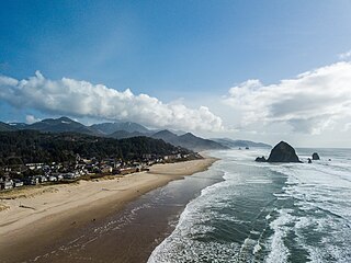
Cannon Beach is a city in Clatsop County, Oregon, United States. Its population was 1,690 at the 2010 census. It is a popular coastal Oregon tourist destination, famous for Haystack Rock, a 235 ft (72 m) sea stack that juts out along the coast. In 2013, National Geographic listed it as "one of the world’s 100 most beautiful places."
A seaside resort is a city, town, village, or hotel that serves as a vacation resort and is located on a coast. Sometimes the concept includes an aspect of official accreditation based on the satisfaction of certain requirements, such as in the German Seebad. Where a beach is the primary focus for tourists, it may be called a beach resort.
The Bass Coast Shire is a local government area in Victoria, Australia, located in the southeastern part of the state. It covers an area of 866 square kilometres (334 sq mi) and in June 2018 had a population of 35,327. It includes the towns of Bass, Cape Paterson, Cape Woolamai, Corinella, Coronet Bay, Cowes, Inverloch, Kilcunda, Lang Lang, Newhaven, Rhyll, San Remo, Summerlands and Wonthaggi as well as the historic locality of Krowera. It also includes the popular tourist destination Phillip Island. It was formed in 1994 from the amalgamation of the Shire of Bass, Shire of Phillip Island, Borough of Wonthaggi, parts of the Shire of Woorayl, Shire of Korumburra and City of Cranbourne.
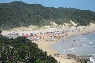
Margate is a coastal resort town in the Kwa-Zulu Natal province, about 20 kilometres south-west of Port Shepstone and 127 kilometres south-west of Durban. The river which flows into the sea at Margate is called "Nkhongweni" (place of entreaty) as the original inhabitants of the area were reputed to be so mean resulting in travellers begging for hospitality.
Swellendam is the fourth oldest town in South Africa, a town with 17,537 inhabitants situated in the Western Cape province. The town has over 50 provincial heritage sites, most of them buildings of Cape Dutch architecture. Swellendam is situated on the N2, approximately 220 km from both Cape Town and George.
False Bay is a body of water in the Atlantic Ocean between the mountainous Cape Peninsula and the Hottentots Holland Mountains in the extreme south-west of South Africa. The mouth of the bay faces south and is demarcated by Cape Point to the west and Cape Hangklip to the east. The north side of the bay is the low-lying Cape Flats, and the east side is the foot of the Hottentots Holland Mountains to Cape Hangklip which is at nearly the same latitude as Cape Point. In plan the bay is approximately square, being roughly the same extent from north to south as east to west, with the southern side open to the ocean. The seabed slopes gradually down from north to south, and is mostly fairly flat unconsolidated sediments. Much of the bay is off the coast of the City of Cape Town, and it includes part of the Table Mountain National Park Marine Protected Area and the whole of the Helderberg Marine Protected Area. The name "False Bay" was applied at least three hundred years ago by sailors returning from the east who confused Cape Point and Cape Hangklip, which are somewhat similar in form.
Alexandria is a small farming town in the Eastern Cape of South Africa and is situated 100 km North East of Gqeberha, Eastern Cape, on the way to Bushman's River Mouth, Kenton-on-Sea and Port Alfred. Alexandria is part of the Ndlambe Local Municipality in the Sarah Baartman District Municipality of the Eastern Cape.
The Tsitsikamma National Park is a protected area on the Garden Route, Western Cape and Eastern Cape, South Africa. It is a coastal reserve well known for its indigenous forests, dramatic coastline, and the Otter Trail. On 6 March 2009 it was amalgamated with the Wilderness National Park and various other areas of land to form the Garden Route National Park.
Boknesstrand is a small seaside town in the Eastern Cape of South Africa. It is close to Cannon Rocks, Kenton-on-Sea, Alexandria, Bushman's River Mouth and Port Alfred. It is part of the Ndlambe Local Municipality in the Sarah Baartman District of the Eastern Cape.
Morgan Bay is a village in Amathole District Municipality in the Eastern Cape province of South Africa.
Vleesbaai, a seaside vacation town, situated between Mossel Bay and Gouritsmond in Western Cape, South Africa.
The Betty's Bay Marine Protected Area is part of the Kogelberg Biosphere Reserve. It is about 29km south-east of Gordon's Bay and approximately 37km north-west of Hermanus on the south-western coast of the Western Cape. It is in the Atlantic Ocean immediately adjacent to the town of Betty's Bay, in the Overstrand Municipal area.
The Helderberg Marine Protected Area is a small marine conservation area on the north-eastern side of False Bay in the Western Cape province of South Africa, It lies between the mouths of the Lourens River in the Strand, and the Eerste River in Macassar.
The Tstsikamma Marine Protected Area is a marine protected area on the south coast of South Africa, in both the Western Cape and Eastern Cape. It is on the coast of the Tsitsikamma National Park, and is one of the oldest MPAs in the country. The MPA provides protection for marine habitat and wildlife, including birds and threatened and endangered fish species.
The Addo Elephant National Park Marine Protected Area is a marine conservation area in Algoa Bay, adjacent to the Nelson Mandela Bay Metropolitan Municipality, near Gqeberha, previously Port Elizabeth.
The Jutten Island Marine Protected Area is an inshore conservation region in the territorial waters of South Africa in Saldanha Bay, in the Western Cape.
This is a list of seaside resorts in South Africa. These seaside resorts are in the Eastern Cape, KwaZulu-Natal, Northern Cape and Western Cape provinces which are all coastal provinces of South Africa.
The Rocherpan Marine Protected Area is a small coastal conservation region on the West Coast of the Western Cape province, in the territorial waters of South Africa. It is about 25 km north of Velddrif on the road to Elands Bay, north of Dwarskersbos.
The Sixteen Mile Beach Marine Protected Area is a coastal conservation region in the territorial waters of South Africa, near Saldanha Bay on the Western Cape coast. The MPA is part of the West Coast National Park which is the core component of the Cape West Coast Biosphere Reserve.