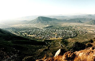
Graaff-Reinet is a town in the Eastern Cape Province of South Africa. It is the oldest town in the province and the fifth oldest town in South Africa, after Cape Town, Stellenbosch, Simon's Town, Paarl and Swellendam. The town was the centre of a short-lived republic in the late 18th century. The town was a starting point for Great Trek groups led by Gerrit Maritz and Piet Retief and furnished large numbers of the Voortrekkers in 1835–1842.

George Municipality is a local municipality within the Garden Route District Municipality, in the Western Cape province of South Africa. As of 2011, the population is 193,672. Its municipality code is WC044.

Mossel Bay Municipality is a local municipality within the Garden Route District Municipality, in the Western Cape province of South Africa. As of 2011, the population was 89,430.
Langeberg Municipality, known before 28 August 2009 as Breede River/Winelands Municipality, is a local municipality located within the Cape Winelands District Municipality, in the Western Cape province of South Africa. As of 2011, it had a population of 97,724. Its municipality code is WC026.
Beaufort West Municipality is a local municipality located in the Western Cape province of South Africa. As of 2011, the population is 49,586. Its municipality code is WC053.

Drakenstein Municipality is a local municipality located within the Cape Winelands District Municipality, in the Western Cape province of South Africa. As of 2011, it had a population of 251,262. Its municipality code is WC023.

Cape Agulhas Municipality is a municipality located in the Western Cape province of South Africa. As of 2011, it had a population of 33,038. Its municipality code is WC033. It is named after Cape Agulhas, the southernmost point of Africa. The largest town is Bredasdorp, which is the seat of the municipal headquarters. It also includes the villages of Napier, Struisbaai, Elim, Arniston and L'Agulhas, and the De Hoop Nature Reserve.
Saldanha Bay Municipality is a local municipality located within the West Coast District Municipality, in the Western Cape province of South Africa. As of 2011, it had a population of 99,193. Its municipality code is WC014.

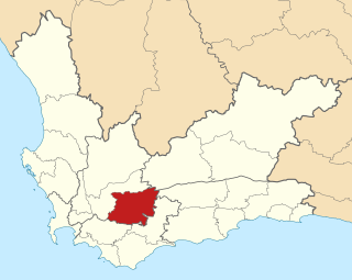
Theewaterskloof Municipality is a local municipality located within the Overberg District Municipality, in the Western Cape province of South Africa. As of 2022, the population was 139,563. Its municipality code is WC031. The enormous Theewaterskloof Dam, which provides water for Cape Town and the surrounding areas, is located in the municipality.
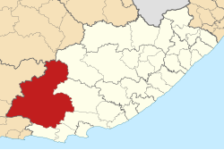
The Sarah Baartman District Municipality, formerly the Cacadu District Municipality, is situated in the western part of the Eastern Cape province of South Africa, covering an area of 58,242 square kilometres. The area of the district municipality includes seven local municipalities. The seat is the city of Gqeberha, although Gqeberha is not itself in the district. As of 2011, the languages most spoken among the 388,201 inhabitants were Xhosa and Afrikaans. The district code is DC10.

Kou-Kamma Municipality is a local municipality in South Africa. It is situated in the southwest corner of the Sarah Baartman District Municipality along the Indian Ocean coastline, in the southwestern sector of South Africa's Eastern Cape province. To the west lies the Western Cape. Kou-Kamma also borders the Dr Beyers Naudé Local Municipality in the north and the Kouga Local Municipality to the east. The geographical area of the municipality is 12,540 square kilometres.

Camdeboo Local Municipality was a local municipality in the Sarah Baartman District Municipality of the Eastern Cape in South Africa. After municipal elections on 3 August 2016 it was merged into the larger Dr Beyers Naudé Local Municipality.

Baviaans Local Municipality was an administrative area in the Sarah Baartman District of the Eastern Cape in South Africa. After the municipal elections on 3 August 2016 it was merged into the larger Dr Beyers Naudé Local Municipality.

Ikwezi Local Municipality was a local municipality in the Sarah Baartman District Municipality of the Eastern Cape in South Africa. Ikwezi is an isiXhosa name that means "morning star". After municipal elections on 3 August 2016 it was merged into the larger Dr Beyers Naudé Local Municipality.

Pearston is a small town in the eastern Karoo, in the Eastern Cape province of South Africa. It lies between Graaff-Reinet and Somerset East at the foot of the Coetzeesberge, about 160 kilometres (100 mi) north of Port Elizabeth. It falls within the Blue Crane Route Local Municipality and has a population of approximately 4,500 people.

Samantha Jane Graham is a South African politician from the Eastern Cape who was elected to the National Assembly of South Africa in the 2019 general election and re-elected in the 2024 general election as a member of the Democratic Alliance. Graham has been the Deputy Minister of Electricity since 2024. Graham served as the shadow deputy minister of public works and infrastructure from 2019 to 2020 and as the shadow minister for the portfolio between 2020 and 2023, when she was named shadow minister of electricity. She is a former councillor of the Dr Beyers Naudé Local Municipality.
The council of the Dr Beyers Naudé Local Municipality is elected every five years by a system of mixed-member proportional representation. Twelve of the twenty-four councillors are elected by first-past-the-post voting from individual wards, while the other twelve are appointed from party lists so that the total number of party representatives is proportional to the number of votes received. By-elections are held to replace the councillors elected by wards if a vacancy occurs.
The council of the Camdeboo Local Municipality was elected in 2000, 2006 and 2011 by a system of mixed-member proportional representation. Half of the councillors were elected by first-past-the-post voting from individual wards, while the other half were appointed from party lists so that the total number of party representatives was proportional to the number of votes received.
The council of the Ikwezi Local Municipality was elected in 2000, 2006 and 2011. The first two elections were conducted by a system of party-list proportional representation, while the 2011 election used mixed-member proportional representation. In 2016 the Ikwezi Local Municipality was merged with two others to create the Dr Beyers Naudé Local Municipality; for election results in the merged municipality see Dr Beyers Naudé Local Municipality elections.
The council of the Baviaans Local Municipality was elected in 2000, 2006 and 2011. The first two elections were conducted by a system of party-list proportional representation, while the 2011 election used mixed-member proportional representation. In 2016 the Baviaans Local Municipality was merged with two others to create the Dr Beyers Naudé Local Municipality; for election results in the merged municipality see Dr Beyers Naudé Local Municipality elections.