The history of the Cape Colony from 1806 to 1870 spans the period of the history of the Cape Colony during the Cape Frontier Wars, which lasted from 1779 to 1879. The wars were fought between the European colonists and the native Xhosa who, defending their land, fought against European rule.

The Eastern Cape is one of the nine provinces of South Africa. Its capital is Bhisho, and its largest city is Gqeberha. Due to its climate and nineteenth-century towns, it is a common location for tourists. It is also known for being home to many anti-apartheid activists, including Nelson Mandela.

At least thirty-five languages are spoken in South Africa, twelve of which are official languages of South Africa: Ndebele, Pedi, Sotho, South African Sign Language, Swazi, Tsonga, Tswana, Venda, Afrikaans, Xhosa, Zulu, and English, which is the primary language used in parliamentary and state discourse, though all official languages are equal in legal status. In addition, South African Sign Language was recognised as the twelfth official language of South Africa by the National Assembly on 3 May 2023. Unofficial languages are protected under the Constitution of South Africa, though few are mentioned by any name.

Qonce, formerly known as King William's Town, is a town in the Eastern Cape province of South Africa along the banks of the Buffalo River. The town is about 60 kilometres (37 mi) northwest of the Indian Ocean port of East London. It has a population of around 35,000 inhabitants and forms part of the Buffalo City Metropolitan Municipality.
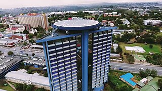
Mthatha ; Xhosa:[ḿ̩ˈtʰâːtʰà], alternatively rendered Umtata, is the main city of the King Sabata Dalindyebo Local Municipality in Eastern Cape province of South Africa and the capital of OR Tambo District Municipality. The city has an airport, previously known as the K. D. Matanzima Airport after former leader Kaiser Matanzima. Mthatha derives its name from the nearby Mthatha River which was named after the sneezewood (umtati) trees, famous for their wood and medicinal properties.
The Mpondo People, or simply Ama-Mpondo, is a kingdom in what is now the Eastern Cape. It was established in 1226. The Ama-Mpondo Nation was first ruled by its founder who was King Mpondo kaNjanya who lived around and later the 'Ama-Nyawuza' clan, by nationality referred to themselves as 'Ama-Mpondo'. They are related to other Aba-Mbo kingdoms and chiefdoms in South Africa.

The OR Tambo District Municipality is one of the seven districts of the Eastern Cape province of South Africa. It is within the Wild Coast Region. The seat is Mthatha. As of 2011, the vast majority (94%) of its 1,364,943 inhabitants spoke isiXhosa. The district is named after Oliver Tambo. The district code is DC15.

The Amathole District Municipality is one of the 7 districts of the Eastern Cape province of South Africa. The seat is East London. As of 2011, over 90% of its 892,637 inhabitants spoke isiXhosa. The district code is DC12. Amathole means "calves", the name of the mountain range and forest which forms the northern boundary of the district.
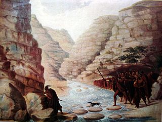
The Xhosa Wars were a series of nine wars between the Xhosa Kingdom and the British Empire as well as Trekboers in what is now the Eastern Cape in South Africa. These events were the longest-running military resistance against European colonialism in Africa.

Butterworth, also known as Gcuwa, is a town in the Eastern Cape Province, South Africa. Butterworth has a population of 45,900 and is situated on the N2 national highway 111 km north of East London.

Pondoland or Mpondoland, is a natural region on the South African shores of the Indian Ocean. It is located in the coastal belt of the Eastern Cape province. Its territory is the former Mpondo Kingdom of the Mpondo people.

Nyandeni Municipality is a local municipality within the OR Tambo District Municipality, in the Eastern Cape province of South Africa. Its administrative seat is the town of Libode. The entire municipal area falls within the former Transkei Bantustan area. The urban population is mainly located in the two small towns of Libode and Ngqeleni.
Libode is a small town of 5000 inhabitants in the Eastern Cape province of South Africa. It is situated on the R61 road from Port St Johns in the east to Mthatha in the west and serves as the administrative seat of the Nyandeni Local Municipality, which is part of the OR Tambo District Municipality. As a small infrastructural hub for the surrounding rural area, Libode features a community college and a hospital, the St Barnabas Hospital.
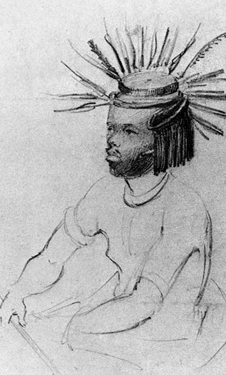
King (iKumkani) Maxhob'ayakhawuleza Sandile "Aa! Zanesizwe!" was the son of the late King Mxolisi Sandile "Aa! Bazindlovu", who was the son of King Archie Velile Sandile, and Queen Nolizwe, the daughter of Western Mpondoland King Victor Poto Ndamase "Aa! Bhekuzulu", and sister to both King Tutor Vulindlela Ndamase "Aa! Nyangelizwe" and the wife of Chief Thandathu Jongilizwe Mabandla of the AmaBhele aseTyhume royal clan. He was the 6th descendant of Sandile and 10th descendant of King Phalo, the Son of King Tshiwo.

Umzimvubu Municipality is a local municipality within the Alfred Nzo District Municipality, in the Eastern Cape province of South Africa. Umzimvubu, the name of the Mzimvubu River, is an isiXhosa word meaning "home of the hippopotamus". The municipal area comprises an area of 2506 square kilometres. The municipality has undergone a number of amendments in terms of municipal and ward demarcation which has a profound impact on planning in the area.

Port St. Johns is a town of about 6,500 people on the Wild Coast in the Eastern Cape province of South Africa. It is situated at the mouth of the Umzimvubu River, 220 kilometres (140 mi) northeast of East London and 70 kilometres (40 mi) east of Mthatha. Port St. Johns was the birthplace of Capital Radio 604.

Qumbu is a town in OR Tambo District Municipality in the Eastern Cape province of South Africa.

Mzimvubu River or Umzimvubu River is one of the most important rivers in South Africa. It is located in the Eastern Cape Province.
Canzibe is a village of 1,000 inhabitants in the Eastern Cape province of South Africa. It is situated near the R61 road from Port St. Johns to Mthatha in the Nyandeni Local Municipality, which is part of the OR Tambo District Municipality. As a small village it features some primary schools and a hospital, the Canzibe Hospital.