
George Municipality is a local municipality within the Garden Route District Municipality, in the Western Cape province of South Africa. As of 2011, the population is 193,672. Its municipality code is WC044.
Tswaing Municipality is a local municipality within the Ngaka Modiri Molema District Municipality, in the North West province of South Africa. It consists of the towns of Delareyville, Sannieshof and Ottosdal.

KwaDukuza Local Municipality is one of four municipalities under iLembe District Municipality, KwaZulu-Natal, South Africa. As of 2022 it has a population of 324,912.
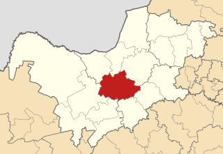
Merafong City Municipality is a local municipality in the West Rand District Municipality, in the Gauteng province of South Africa. Its boundaries encloses some of the richest gold mines in the world. It is situated about 65 km from Johannesburg and is serviced by a number of major roads, including the N12 from Johannesburg to Kimberley and the N14.
Mbhashe Municipality is a local municipality in the Eastern Cape province of South Africa. The municipality was constituted in terms of the Municipal Structures Act of 1998 and comprises the areas that previously formed the Elliotdale, Willowvale and Dutywa town councils. The municipality is located in the north eastern part of the Amathole District Municipality. The main administrative office is situated in Dutywa.

Karoo Hoogland Municipality is a local municipality within the Namakwa District Municipality, in the Northern Cape province of South Africa. The municipality incorporates the towns of Williston, Fraserburg and Sutherland. Although the towns are separated by more than 100 km by road, they share many administrative tasks.

uMhlathuze Local Municipality is an administrative area in the King Cetshwayo District Municipality of KwaZulu-Natal in South Africa. The municipality is named after the Mhlatuze River.

Maphumulo Local Municipality is an administrative area in the iLembe District of KwaZulu-Natal in South Africa. Maphumulo is an isiZulu name meaning "place of rest".

Blue Crane Route Municipality is a local municipality within the Sarah Baartman District Municipality, in the Eastern Cape of South Africa. The municipality is named after the South African national bird, the blue crane.

Elundini Municipality is a local municipality within the Joe Gqabi District Municipality, in the Eastern Cape province of South Africa. The name originates from isiZulu and refers to the Drakensberg Mountains.

Mtubatuba Municipality is a local municipality within the Umkhanyakude District Municipality, in the KwaZulu-Natal province of South Africa.

Emalahleni Municipality is a local municipality within the Chris Hani District Municipality, in the Eastern Cape province of South Africa. Emalahleni is an isiXhosa word meaning "a place of coal".

Hlabisa was an administrative area in the Umkhanyakude District of KwaZulu-Natal in South Africa. Hlabisa is an isiZulu surname of the two nkosis (kings) in the area. The municipality was situated within the vicinity of four Tribal Authorities which are the Mkhwanazi Tribal Authority, the Mdletshe Tribal Authority, and two Hlabisa Tribal Authorities.
uMlalazi Local Municipality is an administrative area in the King Cetshwayo District of KwaZulu-Natal in South Africa. The municipality is named after the uMlalazi River.

Lukhanji Local Municipality was an administrative area in the Chris Hani District of the Eastern Cape in South Africa. Lukhanji is a Xhosa name for the mountain that runs from the eastern side of Queenstown to the western side. After municipal elections on 3 August 2016 it was merged into the larger Enoch Mgijima Local Municipality.

Dr AB Xuma Local Municipality is a local municipality within the Chris Hani District Municipality, in the Eastern Cape province of South Africa. Ngcobo is an isiXhosa word for a sweet grass found in the area.

Mthonjaneni is an administrative area in the King Cetshwayo District of KwaZulu-Natal in South Africa.

Ubuhlebezwe Municipality is a local municipality within the Harry Gwala District Municipality, in the KwaZulu-Natal province of South Africa. Ubuhlebezwe is an isiZulu word meaning "the beauty of the land". The name is derived from Alan Paton's novel, Cry, The Beloved Country.

Qumbu is a town in OR Tambo District Municipality in the Eastern Cape province of South Africa.

The Mpondomise people, also called Ama-Mpondomise, are a Xhosa-speaking people. Their traditional homeland has been in the contemporary era Eastern Cape province of South Africa, and during apartheid they were located both in the Ciskei and Transkei region. Like other separate Xhosa-speaking kingdoms such as Aba-Thembu and Ama-Mpondo, they speak Xhosa and are at times considered as part of the Xhosa people.


