Emalahleni Local Municipality, Eastern Cape

Last updated

Emalahleni
Emalahleni Eastern Cape CoA.png
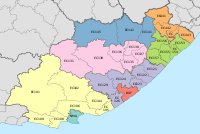
Map of the Eastern Cape with Emalahleni highlighted.svg
Location in the Eastern Cape
Country South Africa
Province Eastern Cape
District Chris Hani
Seat Cacadu
Wards 17
Government
[1]
  Type Municipal council
  MayorNtombizanele Koni (ANC)
  SpeakerDumisa Kalolo (ANC)
  Chief WhipThozama Mrwebi (ANC)
Area
  Total3,447 km2 (1,331 sq mi)
Population
 (2011) [2]
  Total119,460
  Density35/km2 (90/sq mi)
Racial makeup (2011)
[2]
   Black African 98.5%
   Coloured 0.6%
   Indian/Asian 0.1%
   White 0.6%
First languages (2011)
[3]
   Xhosa 95.2%
   English 1.5%
   Afrikaans 1.2%
  Other2.1%
Time zone UTC+2 (SAST)
Municipal codeEC136

Emalahleni Municipality (Xhosa : uMasipala wase Emalahleni) is a local municipality within the Chris Hani District Municipality, in the Eastern Cape province of South Africa. Emalahleni is an isiXhosa word meaning "a place of coal". [4]

Contents

Politics

The municipal council consists of thirty-four members elected by mixed-member proportional representation. Seventeen councillors are elected by first-past-the-post voting in seventeen wards, while the remaining seventeen are chosen from party lists so that the total number of party representatives is proportional to the number of votes received. In the election of 1 November 2021 the African National Congress (ANC) won a majority of twenty-eight seats on the council. The following table shows the results of the election. [5]

PartyWardListTotal
seats
Votes%SeatsVotes%Seats
African National Congress 24,40579.731724,92681.521128
Democratic Alliance 1,8896.1701,9466.3622
Economic Freedom Fighters 1,6085.2501,6345.3422
United Democratic Movement 6202.0307672.5111
Independent South African National Civic Organisation 6192.0207032.3011
Independent candidates 1,0033.2800
African Transformation Movement 2590.8504221.3800
African People's Convention 2050.6701790.5900
Total30,608100.001730,577100.001734
Valid votes30,60898.0430,57797.89
Invalid/blank votes6111.966602.11
Total votes31,219100.0031,237100.00
Registered voters/turnout59,23052.7159,23052.74

Main places

The 2001 census divided the municipality into the following main places: [6]

PlaceCodeArea (km2)Population
Cacadu 22301 245.0713,780
Cala 22302 9.6857
Dordrecht 22303 15.674,454
Emaqwatini 22305 27.011,920
Eqolombeni 22306 61.561,603
Guba 22307 315.778,807
Hala 22308 114.032,835
Indwe 22309 12.171,425
Cacadu 22310 24.71729
Lakishi 22311 23.793,557
Macubeni 22312 350.5616,760
Manyano 22313 0.161,370
Mavuya 22314 0.593,023
Mhlontlo 22315 340.6918,960
Mzamomhle 22316 0.29880
Nonesi 22317 557.5928,776
Sinakho 22318 1.394,279
Remainder of the municipality 22304 1,134.112,732

Related Research Articles

<span class="mw-page-title-main">Mbhashe Local Municipality</span> Local municipality in Eastern Cape, South Africa

Mbhashe Municipality is a local municipality in the Eastern Cape province of South Africa. The municipality was constituted in terms of the Municipal Structures Act of 1998 and comprises the areas that previously formed the Elliotdale, Willowvale and Dutywa town councils. The municipality is located in the north eastern part of the Amathole District Municipality. The main administrative office is situated in Dutywa.

<span class="mw-page-title-main">Emalahleni Local Municipality, Mpumalanga</span> Local municipality in Mpumalanga, South Africa

Emalahleni Municipality is a local municipality within the Nkangala District Municipality, in the Mpumalanga province of South Africa. eMalahleni is a Nguni word meaning place of coal.

<span class="mw-page-title-main">Emthanjeni Local Municipality</span> Local municipality in Northern Cape, South Africa

Emthanjeni Municipality is a local municipality within the Pixley ka Seme District Municipality, in the Northern Cape province of South Africa. Emthanjeni is a Xhosa word meaning "vein", symbolising the importance of an underground water supply system to the area. It is also a translation of the name of the municipality's seat, De Aar.

<span class="mw-page-title-main">Kgetlengrivier Local Municipality</span> Local municipality in North West, South Africa

Kgetlengrivier Municipality is a local municipality within the Bojanala Platinum District Municipality, in the North West province of South Africa.

<span class="mw-page-title-main">City of Matlosana</span> Local municipality in North West, South Africa

The City of Matlosana, formerly the City Council of Klerksdorp, is a local municipality within the Dr Kenneth Kaunda District Municipality, in the North West province of South Africa.

<span class="mw-page-title-main">Kopanong Local Municipality</span> Local municipality in Free State, South Africa

Kopanong Municipality is a local municipality within the Xhariep District Municipality, in the Free State province of South Africa. Kopanong is a Sesotho word meaning "meeting place or where people are invited". The name earmarks unity and seeks to encourage co-operation.

<span class="mw-page-title-main">Tswelopele Local Municipality</span> Local municipality in Free State, South Africa

Tswelopele Municipality is a local municipality within the Lejweleputswa District Municipality, in the Free State province of South Africa. Tswelopele is a Sesotho word meaning "progress".

<span class="mw-page-title-main">Blue Crane Route Local Municipality</span> Local municipality in Eastern Cape, South Africa

Blue Crane Route Municipality is a local municipality within the Sarah Baartman District Municipality, in the Eastern Cape of South Africa. The municipality is named after the South African national bird, the blue crane.

<span class="mw-page-title-main">Elundini Local Municipality</span> Local municipality in Eastern Cape, South Africa

Elundini Municipality is a local municipality within the Joe Gqabi District Municipality, in the Eastern Cape province of South Africa. The name originates from isiZulu and refers to the Drakensberg Mountains.

<span class="mw-page-title-main">Letsemeng Local Municipality</span> Local municipality in Free State, South Africa

Letsemeng Municipality is a local municipality within the Xhariep District Municipality, in the Free State province of South Africa.
<span class="mw-page-title-main">Great Kei Local Municipality</span> Local municipality in Eastern Cape, South Africa

Great Kei Municipality is a local municipality within the Amathole District Municipality, in the Eastern Cape province of South Africa. The word Kei is of Khoekhoe origin, meaning "sand". The municipality is named after the Great Kei River.

<span class="mw-page-title-main">Amahlathi Local Municipality</span> Local municipality in Eastern Cape, South Africa

Amahlathi Municipality is a local municipality within the Amatole District Municipality, in the Eastern Cape province of South Africa. Amahlati is an isiXhosa word meaning "a place where many trees are grouped together, a forest". Forests are a key feature of the area.

<span class="mw-page-title-main">Ngqushwa Local Municipality</span> Local municipality in Eastern Cape, South Africa

Ngqushwa Municipality is a local municipality within the Amatole District Municipality, in the Eastern Cape province of South Africa.

<span class="mw-page-title-main">Inkwanca Local Municipality</span> Former local municipality in Eastern Cape, South Africa

Inkwanca Local Municipality was a local municipality that forms part of the Chris Hani District Municipality in the Eastern Cape province of South Africa. Inkwanca is an isiXhosa name meaning cold. The municipal area is the coldest area in the country and the lowest temperatures are recorded in the area every year. After municipal elections on 3 August 2016 it was merged into the larger Enoch Mgijima Local Municipality.

<span class="mw-page-title-main">Sakhisizwe Local Municipality</span> Local municipality in Eastern Cape, South Africa

Sakhisizwe Municipality is a local municipality within the Chris Hani District Municipality, in the Eastern Cape province of South Africa. Sakhisizwe is an isiXhosa word meaning "we are building the nation".

<span class="mw-page-title-main">Engcobo Local Municipality</span> Local municipality in Eastern Cape, South Africa

Engcobo Municipality is a local municipality within the Chris Hani District Municipality, in the Eastern Cape province of South Africa. Ngcobo is an isiXhosa word for a sweet grass found in the area.
<span class="mw-page-title-main">Senqu Local Municipality</span> Local municipality in Eastern Cape, South Africa

Senqu Municipality is a local municipality within the Joe Gqabi District Municipality, in the Eastern Cape province of South Africa. Senqu is the Sesotho name for the Orange River.

<span class="mw-page-title-main">Masilonyana Local Municipality</span> Local municipality in Free State, South Africa

Masilonyana Municipality is a local municipality within the Lejweleputswa District Municipality, in the Free State province of South Africa. Masilonyana is a Setswana word meaning "freedom".

The Emalahleni Local Municipality council consists of thirty-four members elected by mixed-member proportional representation. Seventeen councillors are elected by first-past-the-post voting in seventeen wards, while the remaining seventeen are chosen from party lists so that the total number of party representatives is proportional to the number of votes received. In the election of 3 August 2016 the African National Congress (ANC) won a majority of twenty-eight seats.

The Emalahleni Local Municipality is a Local Municipality in Mpumalanga in South Africa. The council consists of sixty-eight members elected by mixed-member proportional representation. Thirty-four councillors are elected by first-past-the-post voting in thirty-four wards, while the remaining thirty-four are chosen from party lists so that the total number of party representatives is proportional to the number of votes received. In the election of 1 November 2021 the African National Congress (ANC) won a majority of thirty-five seats.

References

  1. "Contact list: Executive Mayors". Government Communication & Information System. Archived from the original on 14 July 2010. Retrieved 22 February 2012.
  2. 1 2 "Statistics by place". Statistics South Africa. Retrieved 27 September 2015.
  3. "Statistics by place". Statistics South Africa. Retrieved 27 September 2015.
  4. South African Languages - Place names
  5. "Election Result Table for LGE2021 — Emalahleni". wikitable.frith.dev. Retrieved 18 December 2021.
  6. Lookup Tables - Statistics South Africa [ permanent dead link ]

31°42′14″S27°13′57″E / 31.70389°S 27.23250°E / -31.70389; 27.23250